|
Los Glaciares National Park
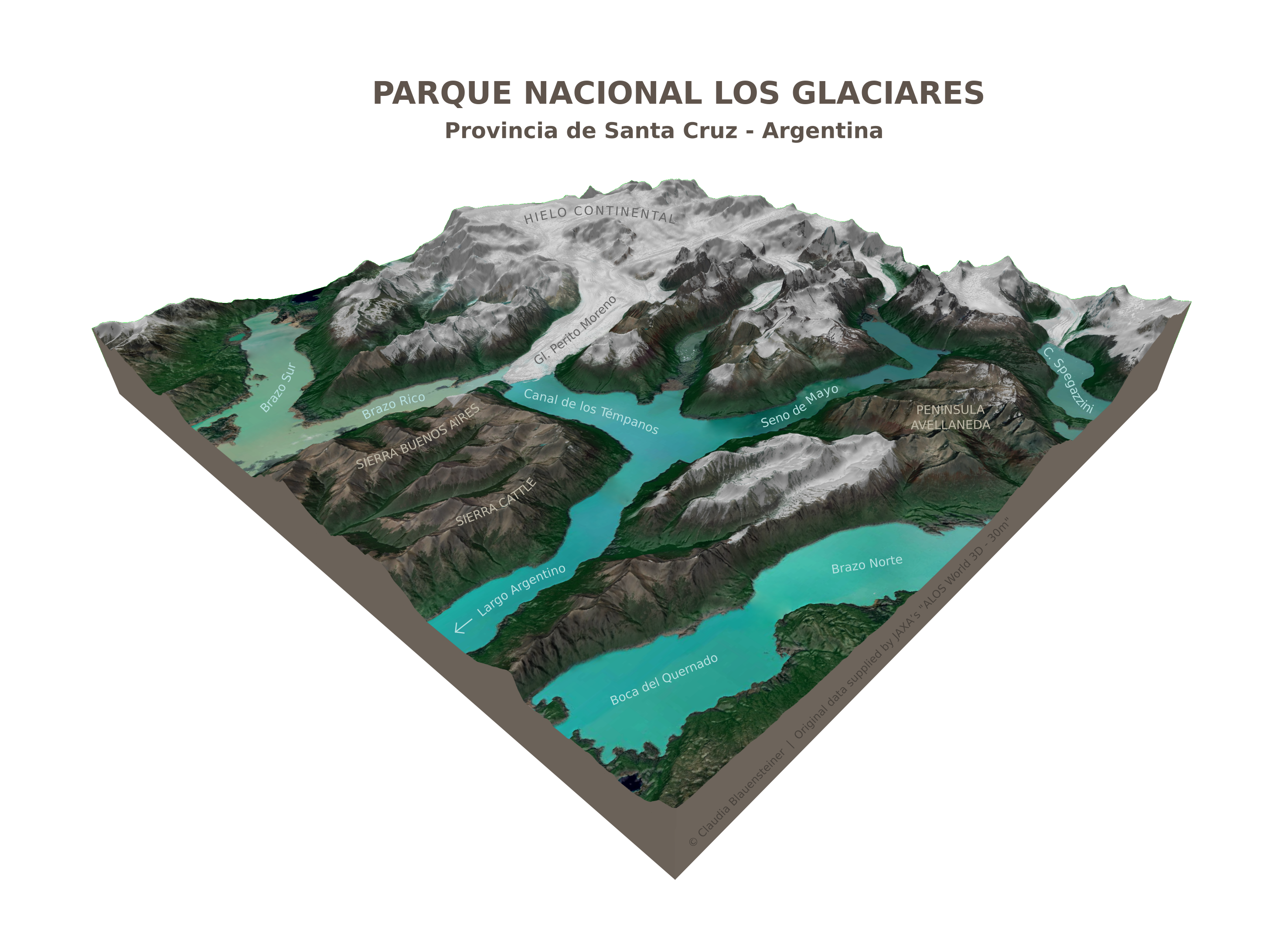
Los Glaciares National Park ( es, Parque Nacional Los Glaciares) is a federal protected area in Santa Cruz Province, Argentina. The park covers an area of , making it the largest national park in the country. Established on 11 May 1937, it hosts a representative sample of Magellanic subpolar forest and west Patagonian steppe biodiversity in good state of conservation. In 1981, it was declared a World Heritage Site by UNESCO. The park's name refers to the giant ice cap in the Andes, the largest outside of Antarctica, Greenland and Iceland, feeding 47 large glaciers, of which 13 flow towards the Pacific Ocean. In other parts of the world, glaciers start at a height of at least above mean sea level, but due to the size of the ice cap, these glaciers begin at only , sliding down to . Los Glaciares borders Torres del Paine National Park to the south in Chilean territory. Geography Los Glaciares, of which 30% is covered by ice, can be divided in two parts, each corresponding wit ... [...More Info...] [...Related Items...] OR: [Wikipedia] [Google] [Baidu] |
Perito Moreno Glacier
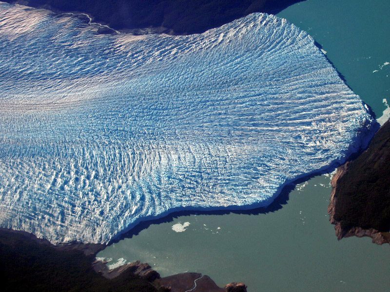
The Perito Moreno Glacier () is a glacier located in Los Glaciares National Park in southwest Santa Cruz Province, Argentina. It is one of the most important tourist attractions in the Argentine Patagonia. The ice formation, in length, is one of 48 glaciers fed by the Southern Patagonian Ice Field located in the Andes system shared with Chile. This ice field is the world's third largest reserve of fresh water. The Perito Moreno Glacier, located from El Calafate, was named after the explorer Francisco Moreno, a pioneer who studied the region in the 19th century and played a major role in defending the territory of Argentina in the conflict surrounding the international border dispute with Chile. Status Despite most of the innumerable glaciers worldwide retreating, one of the few unusual glaciers that maintains in a state of equilibrium is the Perito Moreno Glacier because it continues to accumulate mass at a rate similar to that of its loss. The reason remains debated by glac ... [...More Info...] [...Related Items...] OR: [Wikipedia] [Google] [Baidu] |
Above Mean Sea Level
Height above mean sea level is a measure of the vertical distance (height, elevation or altitude) of a location in reference to a historic mean sea level taken as a vertical datum. In geodesy, it is formalized as ''orthometric heights''. The combination of unit of measurement and the physical quantity (height) is called "metres above mean sea level" in the metric system, while in United States customary and imperial units it would be called "feet above mean sea level". Mean sea levels are affected by climate change and other factors and change over time. For this and other reasons, recorded measurements of elevation above sea level at a reference time in history might differ from the actual elevation of a given location over sea level at a given moment. Uses Metres above sea level is the standard measurement of the elevation or altitude of: * Geographic locations such as towns, mountains and other landmarks. * The top of buildings and other structures. * Flying objects such ... [...More Info...] [...Related Items...] OR: [Wikipedia] [Google] [Baidu] |
Spegazzini Glacier
Los Glaciares National Park ( es, Parque Nacional Los Glaciares) is a federal protected area in Santa Cruz Province, Argentina. The park covers an area of , making it the largest national park in the country. Established on 11 May 1937, it hosts a representative sample of Magellanic subpolar forest and west Patagonian steppe biodiversity in good state of conservation. In 1981, it was declared a World Heritage Site by UNESCO. The park's name refers to the giant ice cap in the Andes, the largest outside of Antarctica, Greenland and Iceland, feeding 47 large glaciers, of which 13 flow towards the Pacific Ocean. In other parts of the world, glaciers start at a height of at least above mean sea level, but due to the size of the ice cap, these glaciers begin at only , sliding down to . Los Glaciares borders Torres del Paine National Park to the south in Chilean territory. Geography Los Glaciares, of which 30% is covered by ice, can be divided in two parts, each corresponding wit ... [...More Info...] [...Related Items...] OR: [Wikipedia] [Google] [Baidu] |
Upsala Glacier
The Upsala Glacier is a large valley glacier on the eastern side of the Southern Patagonian Ice Field. Its higher portion lies in a disputed territory between Chile and Argentina. While the glacier flows from north to south it has three lesser eastflowing tributary glacier: Bertacchi, Cono and Murallón. The glacier terminus is at Upsala channel of Lago Argentino. The Upsala Glacier is well known for its rapid retreat, which Greenpeace cites as evidence for global warming. Its retreat has been ongoing since the glacier was first documented in 1810. The name comes from the old spelling with one ''p'' of Uppsala University, which sponsored the first glaciological studies in the area. The university is located in Uppsala, Sweden. The glacier showed almost continual recession up until 1999. The acceleration in ice motion during the two decades preceding 1999 may have been augmented by the release of backstress when the glacier retreated beyond the islands in Brazo Upsala. In 2008 ... [...More Info...] [...Related Items...] OR: [Wikipedia] [Google] [Baidu] |
Cerro Torre
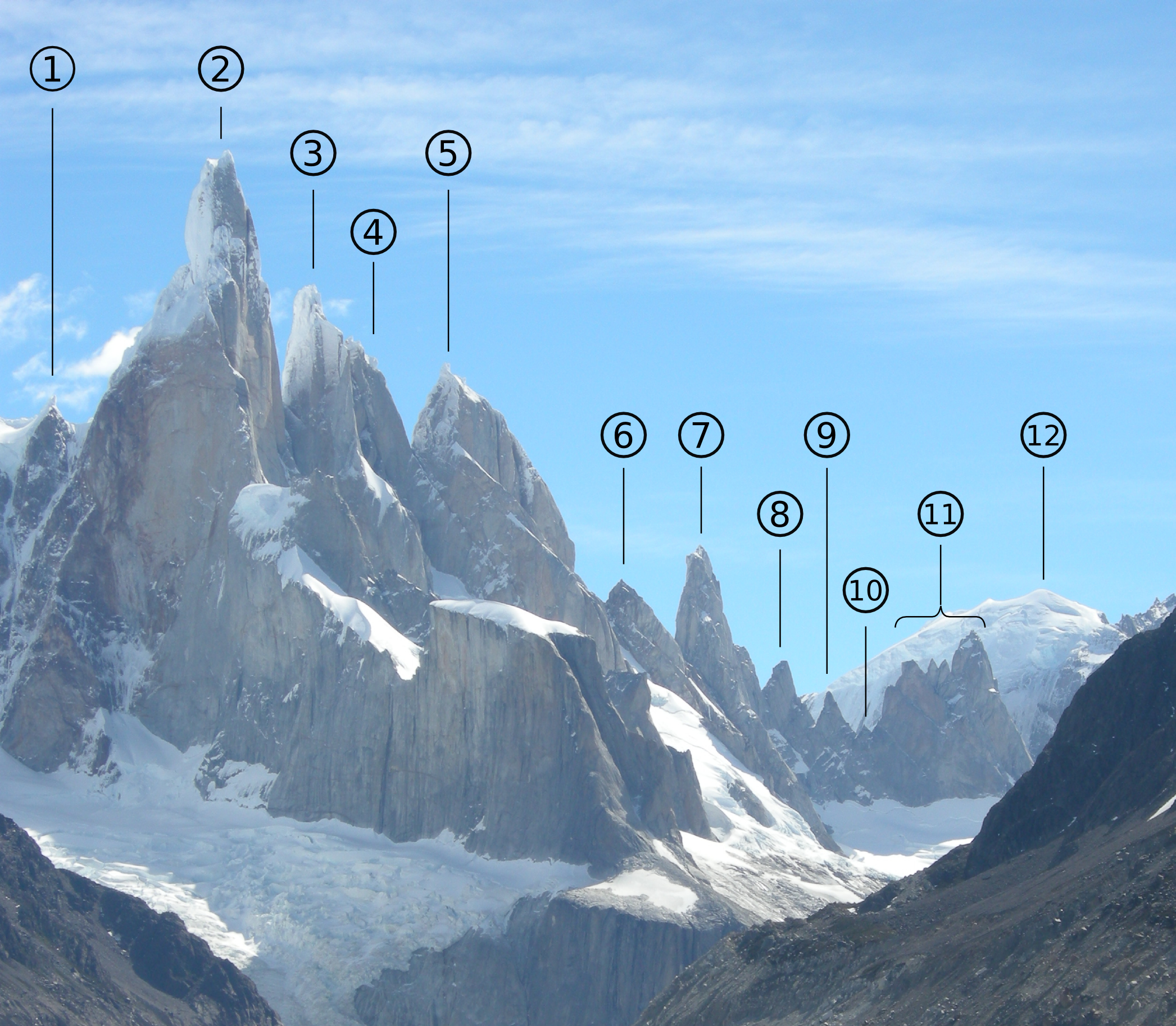
Cerro Torre is one of the mountains of the Southern Patagonian Ice Field in South America. It is located in Argentina and Chile, west of Fitz Roy (also known as Cerro Chaltén). The peak is the highest of a four mountain chain: the other peaks are Torre Egger (), Punta Herron, and Cerro Standhardt. The top of the mountain often has a mushroom of rime ice, formed by the constant strong winds, increasing the difficulty of reaching the actual summit. First ascent Cesare Maestri claimed in 1959 that he and Toni Egger had reached the summit and that Egger had been swept to his death by an avalanche while they were descending. Maestri declared that Egger had the camera with the pictures of the summit, but this camera was never found. Inconsistencies in Maestri's account, and the lack of bolts, pitons or fixed ropes on the route, have led most mountaineers to doubt Maestri's claim. In 2005, Ermanno Salvaterra, Rolando Garibotti and Alessandro Beltrami, after many attempts by world-cla ... [...More Info...] [...Related Items...] OR: [Wikipedia] [Google] [Baidu] |
Cerro Chaltén
Monte Fitz Roy (also known as Cerro Chaltén, Cerro Fitz Roy, or simply Mount Fitz Roy) is a mountain in Patagonia, on the border between Argentina and Chile.MONTE FITZ ROY ''Andes Hand Book, www.andeshandbook.org'', accessed 21 June 2021 /ref> ''www.interpatagonia.com'', accessed 21 June 2021 It is located in the |
Viedma Glacier
Viedma Glacier is a large glacier that is part of the huge Southern Patagonian Ice Field, located at the southern end of mainland South America. Viedma Glacier is a valley glacier and its moraine-rich terminus flows into the western end of Lake Viedma, which is fed primarily by its melting ice. Viedma Glacier is located in the undefined part of the limit between Chile and Argentina, in Argentinian legislature it is in Los Glaciares National Park which was declared a World Heritage Site in 1981. in Chilean legislature part of it is in Bernardo O'Higgins National Park. The Southern Patagonian Ice Field is ; Viedma Glacier is one of the Ice Field's 48 outlet glaciers that have more than of ice field area each. Glacier terminus Viedma Glacier's glacier terminus is about wide at the point it enters Lake Viedma. Chunks of ice fall off the terminus and float off into the lake, eventually melting. Glacial moraines are glacial debris of soil and rock that collect in front of, and al ... [...More Info...] [...Related Items...] OR: [Wikipedia] [Google] [Baidu] |
Viedma Lake
Viedma Lake ( es, Lago Viedma, ) is a Patagonian lake in the province of Santa Cruz, Argentina, situated near its border with Chile. Measuring approximately 50 miles (80 kilometers) in length, it is a major elongated trough lake formed from melting glacial ice. Viedma Lake is the second largest perennial lake located entirely within Argentina."Principal Lagos de la Republica Argentina", http://www.ign.gob.ar/NuestrasActividades/Geografia/DatosArgentina/Lagos, accessed 20 Jul 2018. Note that this list does not include an area figure for the large but seasonal Mar Chiquita. The name of the lake comes from the Spanish explorer Antonio de Viedma, who in 1783 reached its shores, being the first European to do so. The town of El Chaltén and the Andes peaks Cerro Torre and Fitz-Roy lie in the proximity of Lake Viedma. Lake Viedma is fed primarily by the Viedma Glacier at its western end. The Viedma Glacier measures 3 miles (5 kilometers) wide at its terminus at Lake Viedma. The b ... [...More Info...] [...Related Items...] OR: [Wikipedia] [Google] [Baidu] |
Puerto Santa Cruz
Puerto Santa Cruz is a town and municipality in Santa Cruz Province in southern Argentina. It lies near the Atlantic coast on the northern bank of the estuary of Santa Cruz River. It is the second oldest city in the province, being founded in 1878. It was the capital of the Santa Cruz National Territory until took over the position in 1888. The town is a local centre for sheep and cattle farming. The presence of fresh water in an otherwise semi-arid environme ... [...More Info...] [...Related Items...] OR: [Wikipedia] [Google] [Baidu] |
Santa Cruz River, Argentina
Santa Cruz River ( es, Río Santa Cruz) is a river in the Argentine province of Santa Cruz. The Santa Cruz begins at the shore of the Viedma and Argentino Lakes, of glacial origin and located in the Los Glaciares National Park, and runs eastwards before reaching the Atlantic Coast, north of the southern tip of South America, creating a delta. It is one of the last large free-flowing rivers in Patagonia. Dams The river has an important flow of on average, and is used for irrigation. Two dams are planned for the river, the Jorge Cepernic and Nestor Kirchner Dams. They will have a combined installed capacity of 1,740 MW. Contracts to construct the dams were awarded to a consortium of Chinese and domestic companies in August 2013. It is estimated that the dams will destroy over half of the Santa Cruz River ecosystem. History Santa Cruz River was discovered by Europeans during Magellan's circumnavigation of the Earth, by Juan Serrano, captain of the ''Santiago'', one of ... [...More Info...] [...Related Items...] OR: [Wikipedia] [Google] [Baidu] |
Lake Viedma
Viedma Lake ( es, Lago Viedma, ) is a Patagonian lake in the province of Santa Cruz, Argentina, situated near its border with Chile. Measuring approximately 50 miles (80 kilometers) in length, it is a major elongated trough lake formed from melting glacial ice. Viedma Lake is the second largest perennial lake located entirely within Argentina."Principal Lagos de la Republica Argentina", http://www.ign.gob.ar/NuestrasActividades/Geografia/DatosArgentina/Lagos, accessed 20 Jul 2018. Note that this list does not include an area figure for the large but seasonal Mar Chiquita. The name of the lake comes from the Spanish explorer Antonio de Viedma, who in 1783 reached its shores, being the first European to do so. The town of El Chaltén and the Andes peaks Cerro Torre and Fitz-Roy lie in the proximity of Lake Viedma. Lake Viedma is fed primarily by the Viedma Glacier at its western end. The Viedma Glacier measures 3 miles (5 kilometers) wide at its terminus at Lake Viedma. The bro ... [...More Info...] [...Related Items...] OR: [Wikipedia] [Google] [Baidu] |
Lake Argentino
Lago Argentino is a lake in the Patagonian province of Santa Cruz, Argentina, at . It is the biggest freshwater lake in Argentina, with a surface area of (maximum width: ). It has an average depth of , and a maximum depth of . The lake lies within the Los Glaciares National Park in a landscape with numerous glaciers and is fed by the glacial meltwater of several rivers, the water from Lake Viedma brought by the La Leona River, and many mountain streams. Its drainage basin amounts to more than . Waters from Lake Argentino flow into the Atlantic Ocean through the Santa Cruz River. The glaciers, the nearby town of El Calafate and the lake itself are important tourist destinations. The lake in particular is appreciated for fishing. Perch, common galaxias ("puyen grande"), lake trout and rainbow trout — in both anadromous and Potamodromous forms — are all found. ''Lago Argentino'' was also the name of the airport that served the area until 2000. This airport is currently closed ... [...More Info...] [...Related Items...] OR: [Wikipedia] [Google] [Baidu] |


.jpg)