|
Loch Rannoch And Glen Lyon National Scenic Area
The Loch Rannoch and Glen Lyon National Scenic Area is a national scenic area (NSA) covering the area surrounding Loch Rannoch, Glen Lyon, and the Ben Lawers ranges of mountains in Scotland. It is one of 40 such areas in Scotland, which are defined so as to identify areas of exceptional scenery and to ensure its protection from inappropriate development by restricting certain forms of development. The Loch Rannoch and Glen Lyon NSA covers 48,625 ha, most of which lies in the council area of Perth and Kinross, with a small portion lying in Stirling. National scenic areas are primarily designated due to the scenic qualities of an area, however NSAs may well have other special qualities, for example related to culture, history, archaeology, geology or wildlife. Areas with such qualities may be protected via other national and international designations that overlap with the NSA designation. Loch Rannoch and Glen Lyon includes a National nature reserve at Ben Lawers, and there ... [...More Info...] [...Related Items...] OR: [Wikipedia] [Google] [Baidu] |
Loch Rannoch
Loch Rannoch (Scottish Gaelic: ''Loch Raineach'') is a freshwater loch in Perth and Kinross, Scotland. It is over long in a west–east direction with an average width of about , and is deepest at its eastern end, reaching a depth of .Tom Weir. ''The Scottish Lochs''. pp. 69-75. Published by Constable and Company, 1980. The River Tummel begins at its eastern end, where the small village of Kinloch Rannoch can be found, whilst the wild expanse of Rannoch Moor extends to the west of the loch. The area surrounding Loch Rannoch, along with Rannoch Moor itself, was formerly part of the native Caledonian Forest that stretched across much of Northern Scotland. Native forest is now largely absent from much of the area, due partly to logging, and partly to the climate becoming wetter, and Loch Rannoch is now largely surrounded by commercial forestry and open hillsides,Ordnance Survey. ''Landranger'' 1:50000 Sheet 42. Glen Garry and Loch Rannoch. although a small area remains at the Blac ... [...More Info...] [...Related Items...] OR: [Wikipedia] [Google] [Baidu] |
Ben Nevis And Glen Coe National Scenic Area
Ben Nevis and Glen Coe is a national scenic area (NSA) covering part of the Highlands of Scotland surrounding Ben Nevis and Glen Coe, in which certain forms of development are restricted. It is one of 40 such areas in Scotland, which are defined so as to identify areas of exceptional scenery and to ensure its protection from inappropriate development. The Ben Nevis and Glen Coe NSA covers of land, lying within the Highland, Argyll and Bute and Perth and Kinross council areas. A further of the NSA are marine, covering the sea loch of Loch Leven. National scenic areas are primarily designated due to the scenic qualities of an area, however NSAs may well have other special qualities, for example related to culture, history, archaeology, geology or wildlife. Areas with such qualities may be protected via other national and international designations that overlap with the NSA designation. Glen Coe is designated as a national nature reserve, and there are several Special Areas of ... [...More Info...] [...Related Items...] OR: [Wikipedia] [Google] [Baidu] |
Tributary
A tributary, or affluent, is a stream or river that flows into a larger stream or main stem (or parent) river or a lake. A tributary does not flow directly into a sea or ocean. Tributaries and the main stem river drain the surrounding drainage basin of its surface water and groundwater, leading the water out into an ocean. The Irtysh is a chief tributary of the Ob river and is also the longest tributary river in the world with a length of . The Madeira River is the largest tributary river by volume in the world with an average discharge of . A confluence, where two or more bodies of water meet, usually refers to the joining of tributaries. The opposite to a tributary is a distributary, a river or stream that branches off from and flows away from the main stream. PhysicalGeography.net, Michael Pidwirny & S ... [...More Info...] [...Related Items...] OR: [Wikipedia] [Google] [Baidu] |
Topographic Prominence
In topography, prominence (also referred to as autonomous height, relative height, and shoulder drop in US English, and drop or relative height in British English) measures the height of a mountain or hill's summit relative to the lowest contour line encircling it but containing no higher summit within it. It is a measure of the independence of a summit. A peak's ''key col'' (the highest col surrounding the peak) is a unique point on this contour line and the ''parent peak'' is some higher mountain, selected according to various criteria. Definitions The prominence of a peak may be defined as the least drop in height necessary in order to get from the summit to any higher terrain. This can be calculated for a given peak in the following way: for every path connecting the peak to higher terrain, find the lowest point on the path; the ''key col'' (or ''key Saddle point, saddle'', or ''linking col'', or ''link'') is defined as the highest of these points, along all connecting pat ... [...More Info...] [...Related Items...] OR: [Wikipedia] [Google] [Baidu] |
Breadalbane, Scotland
Breadalbane , from Scottish Gaelic ''Bràghaid Albann'' ("upper Alba" or "upland of Alba"), is a region of the southern/central Scottish Highlands. It is a mountainous region comprising the Drainage divide, watershed of Loch Tay; its boundaries are roughly the West Highland Way in the west, Rannoch Moor in the northwest, Loch Rannoch in the north, the River Tummel in the east, the Highland boundary in the southeast, and Loch Earn and Loch Voil-Loch Doine in the south. The former Breadalbane district was surrounded by the districts of Atholl, Strathearn, Menteith, The Lennox, Argyll and Lochaber. The Breadalbane Hydro-Electric Scheme lies within the region. The ''Atholl and Breadalbane Gathering'' is a popular 2/4 March tune for the Great Highland Bagpipes. History image:A new map of Scotland with the roads (8643653080).jpg, 350px, A 1689 map, showing the borders of Breadalbane as a distinct Province (in blue, at the centre of the map, as "broad alba-in") Breadalbane formed one o ... [...More Info...] [...Related Items...] OR: [Wikipedia] [Google] [Baidu] |
History Of Local Government In Scotland
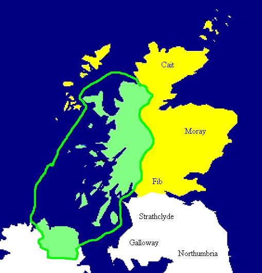
The History of local government in Scotland is a complex tale of largely ancient and long established Scottish political units being replaced after the mid 20th century by a frequently changing series of different local government arrangements. Origins Anciently, the territory now referred to as ''Scotland'' belonged to a mixture of Brythionic groups (Picts and Cumbrians) and Angles. The Picts were based north of the Forth–Clyde line, traditionally in seven kingdoms: *Cat (the far north) * Ce (from Deeside to Speyside) * Circinn (southeast of the Cairngorms, roughly between the Isla and Dee) * Fib (the Fife peninsula) * Fotla (an expanded Atholl) *Fortriu (the areas to the north and west of the Grampians, including the Great Glen, and extending to the Atlantic coast, and as far north as the Dornoch Firth) *Fidach (unknown location). In later legends Albanactus, the legendary founder of Scotland, had seven sons, who each founded a kingdom. ''De Situ Albanie'' enumerates t ... [...More Info...] [...Related Items...] OR: [Wikipedia] [Google] [Baidu] |
Dumfries And Galloway
Dumfries and Galloway ( sco, Dumfries an Gallowa; gd, Dùn Phrìs is Gall-Ghaidhealaibh) is one of 32 unitary council areas of Scotland and is located in the western Southern Uplands. It covers the counties of Scotland, historic counties of Dumfriesshire, Kirkcudbrightshire, and Wigtownshire, the latter two of which are collectively known as Galloway. The administrative centre and largest settlement is the town of Dumfries. The second largest town is Stranraer, on the North Channel (Great Britain and Ireland), North Channel coast, some to the west of Dumfries. Following the 1975 reorganisation of local government in Scotland, the three counties were joined to form a single regions and districts of Scotland, region of Dumfries and Galloway, with four districts within it. The districts were abolished in 1996, since when Dumfries and Galloway has been a unitary local authority. For lieutenancy areas of Scotland, lieutenancy purposes, the area is divided into three lieutenancy a ... [...More Info...] [...Related Items...] OR: [Wikipedia] [Google] [Baidu] |
Stirling Council
Stirling (; sco, Stirlin; gd, Sruighlea ) is a City status in the United Kingdom, city in Central Belt, central Scotland, northeast of Glasgow and north-west of Edinburgh. The market town#Scotland, market town, surrounded by rich farmland, grew up connecting the royal Stirling Castle, citadel, the medieval old town with its merchants and tradesmen, the Stirling Old Bridge, Old Bridge and the port. Located on the River Forth, Stirling is the administrative centre for the Stirling (council area), Stirling council area, and is traditionally the county town of Stirlingshire. Proverbially it is the strategically important "Gateway to the Highlands". It has been said that "Stirling, like a huge brooch clasps Scottish Highlands, Highlands and Scottish Lowlands, Lowlands together". Similarly "he who holds Stirling, holds Scotland" is often quoted. Stirling's key position as the lowest bridging point of the River Forth before it broadens towards the Firth of Forth made it a focal poi ... [...More Info...] [...Related Items...] OR: [Wikipedia] [Google] [Baidu] |
Perth And Kinross Council
Perth and Kinross Council ( gd, Comhairle Pheairt is Cheann Rois) is the local government council for the Perth and Kinross council area of Scotland. It employs around 6,000 people. The council was created in 1996, under the ''Local Government etc. (Scotland) Act 1994'', when the Tayside region was divided between three new unitary council areas: Perth and Kinross, Angus, and Dundee City. The current Perth and Kinross council headquarters are located in Perth at 2 High Street, at Tay Street, although many public enquiries and council services are handled from the nearby Pullar House at 36 Mill Street, the former business premises of J. Pullar and Sons. Elections General elections to the council are held on a four-year cycle. The most recent poll was held in 2022, on Thursday 5 May. The next local election will be held in 2027. As a result of the Local Governance (Scotland) Act 2004 and the recommendations put forth by the Local Government Boundary Commission for Scotl ... [...More Info...] [...Related Items...] OR: [Wikipedia] [Google] [Baidu] |
National Park Authority
A national park authority is a special term used in Great Britain for legal bodies charged with maintaining a national park of which, as of October 2021, there are ten in England, three in Wales and two in Scotland. The powers and duties of all such authorities are similar, but their work varies depending on where they are situated. National park authorities were set up by the Environment Act 1995. __NOTOC__ List of national park authorities England *Peak District National Park Authority *Lake District National Park Authority *Dartmoor National Park Authority * North York Moors National Park Authority *Yorkshire Dales National Park Authority *Exmoor National Park Authority *Northumberland National Park Authority *Broads Authority *New Forest National Park Authority * South Downs National Park Authority Wales *Snowdonia National Park Authority * Pembrokeshire Coast National Park Authority *Brecon Beacons National Park Authority Scotland * Loch Lomond and The Trossachs National P ... [...More Info...] [...Related Items...] OR: [Wikipedia] [Google] [Baidu] |
Rannoch Moor
Rannoch Moor (, gd, Mòinteach Raineach/Raithneach) is an expanse of around of boggy moorland to the west of Loch Rannoch in Scotland, where it extends from and into westerly Perth and Kinross, northerly Lochaber (in Highland), and the area of Highland Scotland toward its south-west, northern Argyll and Bute. Rannoch Moor is designated a Site of Special Scientific Interest (SSSI) and a Special Area of Conservation. Much of the western part of the moor lies within the Ben Nevis and Glen Coe National Scenic Area, one of 40 such areas in Scotland. It is notable for its wildlife, and is particularly famous as being the sole British location for the Rannoch-rush, named after the moor. It was frequently visited by Horace Donisthorpe who collected many unusual species of ants on the moor and surrounding hilly ground. Today it is still one of the few remaining habitats for ''Formica exsecta'', the "narrow-headed ant", although recent surveys have failed to produce any sign of ''Formi ... [...More Info...] [...Related Items...] OR: [Wikipedia] [Google] [Baidu] |
Glen Cannich
Glen Cannich ( gd, Gleann Chanaich) is a long glen in the Northwest Highlands of Scotland and through which runs the River Cannich. Emerging from the reservoir of Loch Mullardoch, the river flows east to merge with the River Affric at the village of Cannich Cannich (Gaelic: ''Canaich'') is a village at the southern end of Strathglass, in the Highlands of Scotland, about west of the city of Inverness. It is at the furthest point of the A831 that loops around the Aird from Beauly to Drumnadrochit. I ..., their combined waters forming the River Glass. Downstream of Loch Mullardoch are the smaller natural lochs of Loch a' Bhana, Loch Sealbhanach, Loch Carrie and Loch Craskie through each of which the river flows. Other lochs within the Cannich catchment include (from west to east) Loch an Fraoich-choire, Coire Lochan, Loch a' Choire Dhomhain, Loch a' Choire Bhig, Loch Tuill Bhearnach and Lochan a' Mhill Dhuibh. Within the narrow confines of the eastern end of the glen the river p ... [...More Info...] [...Related Items...] OR: [Wikipedia] [Google] [Baidu] |


