|
Little Minnesota River
The Little Minnesota River is a U.S. Geological Survey. National Hydrography Dataset high-resolution flowline dataThe National Map , accessed October 5, 2012 headwaters tributary of the Minnesota River in northeastern South Dakota and west-central Minnesota in the United States. Via the Minnesota River, it is part of the Mississippi River watershed. Course The Little Minnesota rises in Marshall County, South Dakota from the Coteau des Prairies near the town of Veblen and flows generally southeastward through Roberts County, where it collects two small tributaries, Standfast Creek and the Jorgenson River. Near the Minnesota state line, it passes within a mile of Lake Traverse, part of the Hudson Bay watershed, from which it is separated by a low continental divide. The river enters Minnesota at the town of Browns Valley and shortly enters Big Stone Lake, which is drained by the Minnesota River. The region between Lake Traverse and Big Stone Lake is known as the Traverse Ga ... [...More Info...] [...Related Items...] OR: [Wikipedia] [Google] [Baidu] |
United States
The United States of America (U.S.A. or USA), commonly known as the United States (U.S. or US) or America, is a country primarily located in North America. It consists of 50 states, a federal district, five major unincorporated territories, nine Minor Outlying Islands, and 326 Indian reservations. The United States is also in free association with three Pacific Island sovereign states: the Federated States of Micronesia, the Marshall Islands, and the Republic of Palau. It is the world's third-largest country by both land and total area. It shares land borders with Canada to its north and with Mexico to its south and has maritime borders with the Bahamas, Cuba, Russia, and other nations. With a population of over 333 million, it is the most populous country in the Americas and the third most populous in the world. The national capital of the United States is Washington, D.C. and its most populous city and principal financial center is New York City. Paleo-Americ ... [...More Info...] [...Related Items...] OR: [Wikipedia] [Google] [Baidu] |
Lake Traverse
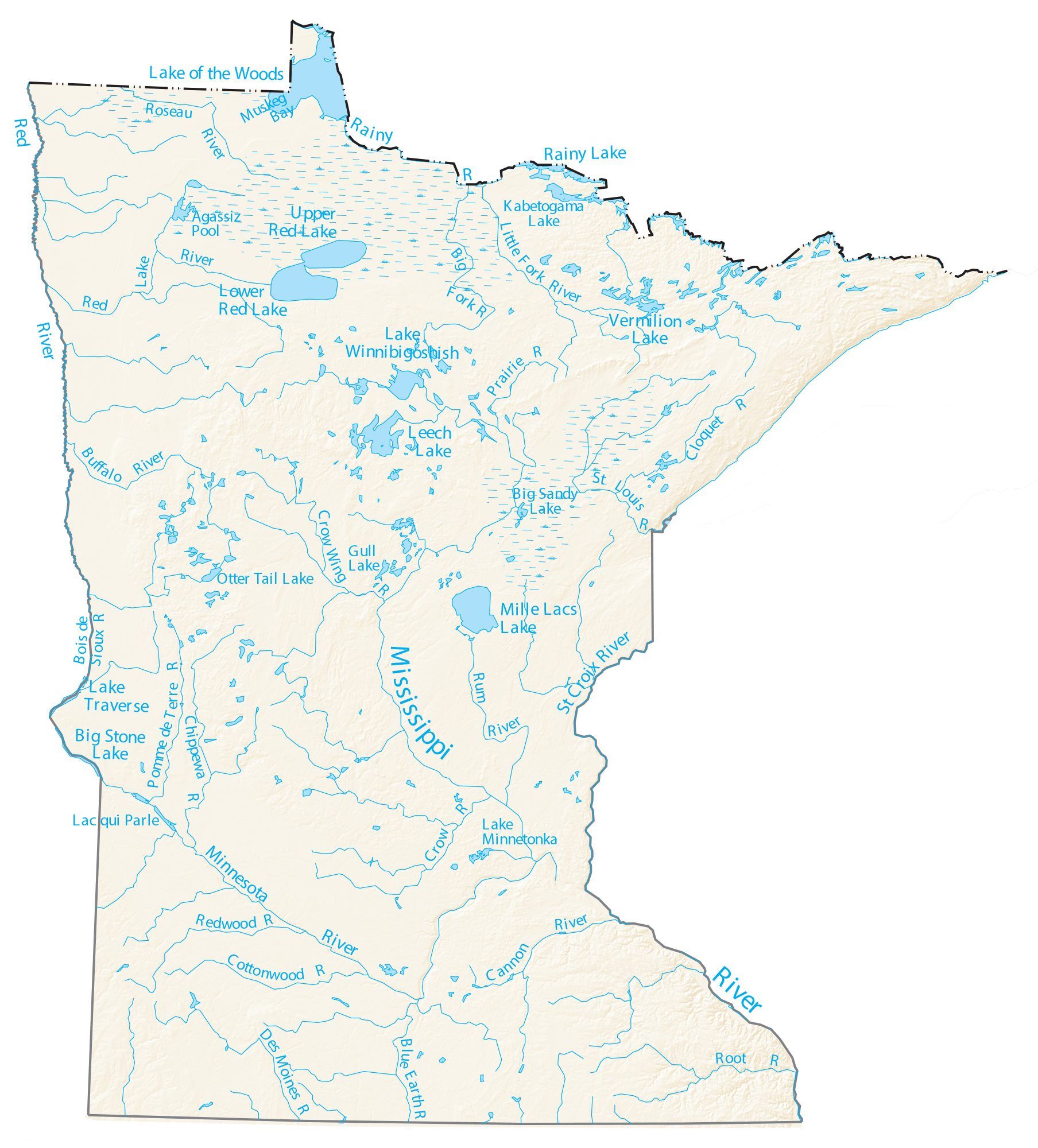
Lake Traverse is the southernmost body of water in the Hudson Bay drainage basin, watershed of North America. It lies along the border between the U.S. states of Minnesota and South Dakota. A low continental divide, part of the Laurentian Divide, separates the land at the southern shore of Lake Traverse from Big Stone Lake, the headwaters of the south-flowing Little Minnesota River, which is part of the Mississippi River System. Both lakes lie within a mile of the town of Browns Valley, Minnesota with Wheaton, Minnesota (at the north end of Lake Traverse); and Ortonville, Minnesota (at the south end of Big Stone Lake). Lake Traverse is an Anglicization of ''Lac Traverse'', a French name meaning "across the lake". Prehistory, Prehistorically, the south end of Lake Traverse was the southern outlet of glacial Lake Agassiz across the Traverse Gap into Glacial River Warren; that river carved the valley now occupied by the present-day Minnesota River. Lake Traverse is drained at its ... [...More Info...] [...Related Items...] OR: [Wikipedia] [Google] [Baidu] |
Rivers Of Minnesota
Minnesota has 6,564 natural rivers and streams that cumulatively flow for . The Mississippi River begins its journey from its headwaters at Lake Itasca and crosses the Iowa border downstream. It is joined by the Minnesota River at Fort Snelling, by the St. Croix River near Hastings, by the Chippewa River at Wabasha, and by many smaller streams. The Red River, in the bed of glacial Lake Agassiz, drains the northwest part of the state northward toward Canada's Hudson Bay. By drainage basin (watershed) This list is arranged by drainage basin with respective tributaries indented under each larger stream's name.Note: In North America, the term watershed is commonly used to mean a drainage basin, though in other English-speaking countries, it is used only in its original sense, that of a drainage divide. The rivers and streams that flow through other states or Minnesota and other states are indicated, as well as the length of major rivers. Great Lakes drainage basin Lake ... [...More Info...] [...Related Items...] OR: [Wikipedia] [Google] [Baidu] |
List Of Rivers Of South Dakota
This is a list of rivers in the state of South Dakota in the United States. By tributary Minnesota River watershed *Little Minnesota River ** Jorgenson River * Whetstone River *North Fork Yellow Bank River *South Fork Yellow Bank River *West Branch Lac qui Parle River Missouri River * Little Missouri River * Grand River **Black Horse Butte Creek **Cedar Boy Creek **Cottonwood Creek **Cottonwood Creek **Cyclone Creek **Dirt Lodge Creek ***Little Soldier Creek **Firesteel Creek **Flat Creek ***East Flat Creek **High Bank Creek **Hump Creek **Lodgepole Creek **Louse Creek **Meadow Creek ** North Fork Grand River ***Billy Young Creek ***Buffalo Creek ***Crooked Creek ****Petes Creek ***Deer Creek ***Horse Creek ***Lone Tree Creek ***Slick Creek **Plum Creek **Rock Creek **Soldier Creek **Stink Creek ***Iron Dog Creek ** South Fork Grand River ***Bar H Creek ***Bog Creek ***Boxelder Creek ***Box Spring Creek ***Brush Creek ***Bull Creek ***Butcher Creek ***Clarks Fork Creek ***Coal Cr ... [...More Info...] [...Related Items...] OR: [Wikipedia] [Google] [Baidu] |
List Of Longest Streams Of Minnesota
Out of the 6,564 streams that flow through the U.S. State of Minnesota, there are 114 streams that are at least 30 miles long. The second longest river in the United States, the Mississippi River, originates in Minnesota before flowing south to the Gulf of Mexico. The longest river entirely within the state of Minnesota is the Minnesota River. Other rivers over 200 miles long include the Red River of the North, Des Moines River, Cedar River, Wapsipinicon River, Little Sioux River, and Roseau River. Sections of several of the longest rivers define sections of the Minnesota border. The Red River of the North forms the border with North Dakota to the west. The Bois de Sioux River forms the border with South Dakota to the west. The Mississippi River, St. Croix River, and the St. Louis River form the border with Wisconsin to the east. The Rainy River and Pigeon River form the border with Ontario, Canada to the north. Minnesota contains three major drainage basins/wate ... [...More Info...] [...Related Items...] OR: [Wikipedia] [Google] [Baidu] |
List Of Rivers Of Minnesota
Minnesota has 6,564 natural rivers and streams that cumulatively flow for . The Mississippi River begins its journey from its headwaters at Lake Itasca and crosses the Iowa border downstream. It is joined by the Minnesota River at Fort Snelling, by the St. Croix River near Hastings, by the Chippewa River at Wabasha, and by many smaller streams. The Red River, in the bed of glacial Lake Agassiz, drains the northwest part of the state northward toward Canada's Hudson Bay. By drainage basin (watershed) This list is arranged by drainage basin with respective tributaries indented under each larger stream's name.Note: In North America, the term watershed is commonly used to mean a drainage basin, though in other English-speaking countries, it is used only in its original sense, that of a drainage divide. The rivers and streams that flow through other states or Minnesota and other states are indicated, as well as the length of major rivers. Great Lakes drainage basin La ... [...More Info...] [...Related Items...] OR: [Wikipedia] [Google] [Baidu] |
Peever, SD
Peever is a town in Roberts County, South Dakota, United States. The population was 180 at the 2020 census. Peever was laid out in 1898, and named in honor of Thomas Henry Peever, a settler. Geography According to the United States Census Bureau, the town has a total area of , all land. Demographics 2010 census As of the census of 2010, there were 168 people, 56 households, and 47 families residing in the town. The population density was . There were 63 housing units at an average density of . The racial makeup of the town was 28.6% White, 65.5% Native American, 0.6% from other races, and 5.4% from two or more races. Hispanic or Latino of any race were 2.4% of the population. There were 56 households, of which 55.4% had children under the age of 18 living with them, 41.1% were married couples living together, 33.9% had a female householder with no husband present, 8.9% had a male householder with no wife present, and 16.1% were non-families. 12.5% of all households were ma ... [...More Info...] [...Related Items...] OR: [Wikipedia] [Google] [Baidu] |
Ice Age
An ice age is a long period of reduction in the temperature of Earth's surface and atmosphere, resulting in the presence or expansion of continental and polar ice sheets and alpine glaciers. Earth's climate alternates between ice ages and greenhouse periods, during which there are no glaciers on the planet. Earth is currently in the Quaternary glaciation. Individual pulses of cold climate within an ice age are termed ''glacial periods'' (or, alternatively, ''glacials, glaciations, glacial stages, stadials, stades'', or colloquially, ''ice ages''), and intermittent warm periods within an ice age are called '' interglacials'' or ''interstadials''. In glaciology, ''ice age'' implies the presence of extensive ice sheets in both northern and southern hemispheres. By this definition, Earth is currently in an interglacial period—the Holocene. The amount of anthropogenic greenhouse gases emitted into Earth's oceans and atmosphere is predicted to prevent the next glacial period for th ... [...More Info...] [...Related Items...] OR: [Wikipedia] [Google] [Baidu] |
Red River Valley
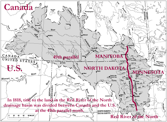
The Red River Valley is a region in central North America that is drained by the Red River of the North; it is part of both Canada and the United States. Forming the border between Minnesota and North Dakota when these territories were admitted as states in the United States, this fertile valley has been important to the economies of these states and to Manitoba, Canada. The population centers of Moorhead, Minnesota, Fargo and Grand Forks, North Dakota, and Winnipeg, Manitoba developed in the valley as settlement by ethnic Europeans increased in the late nineteenth century. Completion of major railroads, availability of cheap lands, and forceful removal of Indigenous people as well as a subsequent refusal to recognize Indigenous land claims attracted many new settlers. Some developed large-scale agricultural operations known as bonanza farms, which concentrated on wheat commodity crops. Paleogeographic Lake Agassiz laid down the Red River Valley Silts. The valley was long an ... [...More Info...] [...Related Items...] OR: [Wikipedia] [Google] [Baidu] |
Lake Agassiz
Lake Agassiz was a large glacial lake in central North America. Fed by glacial meltwater at the end of the last glacial period, its area was larger than all of the modern Great Lakes combined. First postulated in 1823 by William H. Keating, it was named by Warren Upham in 1879 after Louis Agassiz, when Upham recognized that the lake was formed by glacial action. Geological progression During the last ice age, northern North America was covered by an ice sheet, which alternately advanced and retreated with variations in the climate. This continental ice sheet formed during the period now known as the Wisconsin glaciation, and covered much of central North America between 30,000 and 10,000 years ago. As the ice sheet disintegrated, its meltwaters created an immense proglacial lake. Around 13,000 years ago, this lake came to cover much of what are now southeastern Manitoba, northwestern Ontario, northern Minnesota, eastern North Dakota, and Saskatchewan. At its greatest extent ... [...More Info...] [...Related Items...] OR: [Wikipedia] [Google] [Baidu] |
Glacial River Warren
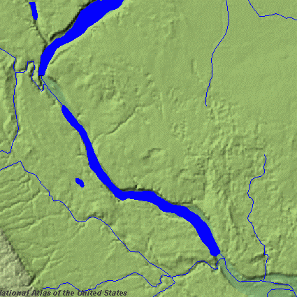
Glacial River Warren, also known as River Warren, was a prehistoric river that drained Lake Agassiz in central North America between about 13,500 and 10,650 BP calibrated (11,700 and 9,400 14C uncalibrated) years ago. A part of the uppermost portion of the former river channel was designated a National Natural Landmark in 1966. Geological history Lake Agassiz was formed from the meltwaters of the Laurentide Ice Sheet during the Wisconsin glaciation of the last ice age. Agassiz was an enormous body of water, up to deep, and at various times covering areas totaling over . Blocked by an ice sheet to the north, the lake water rose until about 13,500 BP calibrated (11,700 14C uncalibrated) years ago when it overtopped the ''Big Stone Moraine'', a ridge of glacial drift left by the receding glacier, at the location of Browns Valley, Minnesota. The lake's outflow was catastrophic, and carved a gorge through the moraine wide and deep, which is now known as the Traverse Gap. The ... [...More Info...] [...Related Items...] OR: [Wikipedia] [Google] [Baidu] |
Traverse Gap
The Traverse Gap is an ancient river channel occupied by Lake Traverse, Big Stone Lake and the valley connecting them at Browns Valley, Minnesota. It is located on the border of the U.S. states of Minnesota and South Dakota. Traverse Gap has an unusual distinction for a valley: it is crossed by a continental divide, and in some floods water has flowed across that divide from one drainage basin to the other. Before the Anglo-American Convention of 1818 it marked the border between British territory in the north and U.S. – or earlier, French – territory in the south. Geological history The Traverse Gap was cut at the end of the last ice age. The Laurentide Ice Sheet decayed and receded as the Wisconsonian glaciation drew to a close, and Glacial Lake Agassiz formed from its meltwaters. Outlets to the north were blocked by the glacier, and the outlet to the south was dammed by the Big Stone Moraine which had been left by the retreat of the ice sheet. Lake Agassiz filled until ... [...More Info...] [...Related Items...] OR: [Wikipedia] [Google] [Baidu] |


