|
Little League World Series (West Region)
The West Region is one of ten United States regions that currently send teams to the Little League World Series, the largest youth baseball competition in the world. The region's participation in the LLWS dates back to 1957, when it was known as the West Region. However, when the LLWS was expanded in 2001 from eight teams (four U.S. teams and four "International" teams from the rest of the world) to 16 teams (eight U.S. and eight International), the former West Region was split into the Northwest Region and a new West Region. The West Region headquarters is in San Bernardino, California. The West Region is made up of four districts in three states. * * (Split into "Northern" and "Southern") * Wyoming was a member of the region from 2002 to 2006. During that time, Hawaii was in the Northwest Region. New Mexico was a part of the region in 2001, but was put in the Southwest Region the following year. Following the 2021 LLWS, Utah and Nevada has been moved to a newly created Mounta ... [...More Info...] [...Related Items...] OR: [Wikipedia] [Google] [Baidu] |
Little League World Series 1957–2000 (West Region)
The original West Region was a region that competed in the Little League World Series between and until it was split into a Northwest Region and a new West Region in 2001. The West Region was inaugurated in 1957. The Region consisted of teams from Alaska, Arizona, Northern California, Southern California, Colorado, Hawaii (since 1962), Idaho, Montana, Nevada, New Mexico, Oregon, Utah, Washington, and Wyoming. Before 1962, Hawaiian teams competed in the Pacific Region (see below). Prior to 1966, teams from Western Canada also competed in the West Region. Little League Baseball expanded the LLWS to sixteen teams for the 2001 Little League World Series. At the same time, the original West Region was split into a new West Region (Arizona, Northern California, Southern California, Hawaii, Nevada, New Mexico, and Utah) and a Northwest Region (Alaska, Colorado, Idaho, Montana, Oregon, Washington, and Wyoming). Colorado and New Mexico moved to the Southwest Region for the 2002 tournament ... [...More Info...] [...Related Items...] OR: [Wikipedia] [Google] [Baidu] |
Tucson, Arizona
, "(at the) base of the black ill , nicknames = "The Old Pueblo", "Optics Valley", "America's biggest small town" , image_map = , mapsize = 260px , map_caption = Interactive map outlining Tucson , image_map1 = File:Pima County Incorporated and Unincorporated areas Tucson highlighted.svg , mapsize1 = 250px , map_caption1 = Location within Pima County , pushpin_label = Tucson , pushpin_map = USA Arizona#USA , pushpin_map_caption = Location within Arizona##Location within the United States , subdivision_type = Country , subdivision_type1 = State , subdivision_type2 = County , subdivision_name = United States , subdivision_name1 = Arizona , subdivision_name2 = Pima , established_title = Founded , established_date = August 20, 1775 , established_title1 = Incorporated , e ... [...More Info...] [...Related Items...] OR: [Wikipedia] [Google] [Baidu] |
Rancho Cucamonga, California
Rancho Cucamonga ( ) is a city located just south of the foothills of the San Gabriel Mountains and Angeles National Forest in San Bernardino County, California, United States. About east of Downtown Los Angeles, Rancho Cucamonga is the 28th most populous city in California. The city's seal, which centers on a cluster of grapes, alludes to the city's agricultural history including wine-making. The city's proximity to major transportation hubs, airports, and highways has attracted the business of several large corporations, including Coca-Cola, Frito-Lay, Big Lots, Mercury Insurance Group, Southern California Edison, and Amphastar Pharmaceuticals. The city had a population of 174,453 according to the 2020 United States Census. The city experiences an average of 287 sunny days per year, compared to a national average of 205 days. Its climate is classified as warm Mediterranean, or ''Csa'', under the Köppen climate classification system. The city's favorable location and host ... [...More Info...] [...Related Items...] OR: [Wikipedia] [Google] [Baidu] |
Granite Bay, California
Granite Bay is a census-designated place (CDP) in Placer County, California, United States. It is part of the Sacramento–Arden-Arcade– Roseville Metropolitan Statistical Area. The population was 21,247 at the 2020 census, up from 20,402 at the 2010 census. The ZIP codes are 95746 and 95661. Granite Bay is a primarily residential suburb of Sacramento and is located just east of Roseville and west of Folsom Lake. Geography Granite Bay is located at (38.748504, -121.179793). According to the United States Census Bureau, the CDP has a total area of , of which, of it is land and of it (0.20 percent) is water. The place name, Granite Bay, is derived from a bay in Folsom Lake, a reservoir on the east side of the town created in 1955. The entire town is underlain by granodiorite of the Penryn Pluton of Cretaceous age, hence the geological basis for the place name. Climate Granite Bay has a hot-summer Mediterranean climate (Köppen climate classification Csa) that ... [...More Info...] [...Related Items...] OR: [Wikipedia] [Google] [Baidu] |
Chandler, Arizona
Chandler is a city in Maricopa County, Arizona, United States, and a suburb in the Phoenix-Mesa-Chandler Metropolitan Statistical Area (MSA). It is bordered to the north and west by Tempe, to the north by Mesa, to the west by Phoenix, to the south by the Gila River Indian Community, and to the east by Gilbert. As of the 2020 census, the population of Chandler was 275,987, up from 236,123 at the 2010 census. History In 1891, Dr. Alexander John Chandler, the first veterinary surgeon in Arizona Territory, settled on a ranch south of Mesa, studying irrigation engineering. By 1900, he had acquired of land, and began drawing up plans for a townsite on what was then known as the Chandler Ranch. The townsite office opened on May 16, 1912. (Soon after celebrating Chandler's Centennial on May 17, 2012, Chandler Museum staff discovered that the city had been celebrating the wrong date. In May 1912, the ''Chandler Arizonan'' newspaper had erroneously published the founding day as Ma ... [...More Info...] [...Related Items...] OR: [Wikipedia] [Google] [Baidu] |
Laramie, Wyoming
Laramie is a city in and the county seat of Albany County, Wyoming, United States. The population was estimated 32,711 in 2019, making it the third-largest city in Wyoming after Cheyenne and Casper. Located on the Laramie River in southeastern Wyoming, the city is north west of Cheyenne, at the junction of Interstate 80 and U.S. Route 287. Laramie was settled in the mid-19th century along the Union Pacific Railroad line, which crosses the Laramie River at Laramie. It is home to the University of Wyoming, WyoTech, and a branch of Laramie County Community College. Laramie Regional Airport serves Laramie. The ruins of Fort Sanders, an army fort predating Laramie, lie just south of the city along Route 287. Located in the Laramie Valley between the Snowy Range and the Laramie Range, the city draws outdoor enthusiasts with its abundance of outdoor activities. In 2011, Laramie was named as one of the best cities in which to retire by ''Money Magazine'', which cited its scenic loc ... [...More Info...] [...Related Items...] OR: [Wikipedia] [Google] [Baidu] |
Anaheim, California
Anaheim ( ) is a city in northern Orange County, California, part of the Los Angeles metropolitan area. As of the 2020 United States Census, the city had a population of 346,824, making it the most populous city in Orange County, the 10th-most populous city in California, and the 56th-most populous city in the United States. Anaheim is the second-largest city in Orange County in terms of land area, and is known for being the home of the Disneyland Resort, the Anaheim Convention Center, and two major sports teams: the Los Angeles Angels baseball team and the Anaheim Ducks ice hockey club. Anaheim was founded by fifty German families in 1857 and incorporated as the second city in Los Angeles County on March 18, 1876; Orange County was split off from Los Angeles County in 1889. Anaheim remained largely an agricultural community until Disneyland opened in 1955. This led to the construction of several hotels and motels around the area, and residential districts in Anaheim soon fol ... [...More Info...] [...Related Items...] OR: [Wikipedia] [Google] [Baidu] |
Aptos, California
Aptos (Ohlone for "The People") is an unincorporated town in Santa Cruz County, California. The town is made up of several small villages, which together form Aptos: Aptos Hills-Larkin Valley, Aptos Village, Cabrillo, Seacliff, Rio del Mar, and Seascape. Together, they have a combined population of 24,402. History Aptos was traditionally inhabited by the Awaswas tribe of Ohlone people. The name is one of only three native words that have survived (in Hispanicized form) as place names in Santa Cruz County (the others are Soquel and Zayante). The first European land exploration of Alta California, the Spanish Portolá expedition, passed through the area on its way north, camping at one of the creeks on October 16, 1769. The expedition diaries don't provide enough information to be sure which creek it was, but the direction of travel was northwest, parallel to the coast. Franciscan missionary Juan Crespi, traveling with the expedition, noted in his diary that, "We stopped on th ... [...More Info...] [...Related Items...] OR: [Wikipedia] [Google] [Baidu] |
Glendale, Arizona
Glendale () is a city in Maricopa County, Arizona, Maricopa County, Arizona, United States, located approximately northwest of Downtown Phoenix. As of the 2020 United States census, 2020 census, it had a population of 248,325. History In the late 1800s the area that is now Glendale was all desert. William John Murphy, a native of New Hartford, New York, who resided in the town of Flagstaff, Arizona, Flagstaff in what was then the territory of Arizona, was in charge of building the Arizona Canal from Granite Reef to New River for the Arizona Canal Company. In 1885, he completed the canal, which would bring water to the desert land. Murphy was deep in debt, since he had agreed to be paid in Arizona Canal Company stock and bonds and land instead of cash. In 1887, Murphy formed the Arizona Improvement Company. His objective was to sell the land and water rights south of the canal. Murphy raised capital from out of state sources in order to meet payroll and construction expenses. ... [...More Info...] [...Related Items...] OR: [Wikipedia] [Google] [Baidu] |
Taylorsville, Utah
Taylorsville is a city in Salt Lake County, Utah. It is part of the Salt Lake City metropolitan area. The population was 60,448 at the time of the 2020 census. Taylorsville was incorporated from the Taylorsville–Bennion CDP and portions of the Kearns metro township on July 1, 1996. The city is located adjacent to Interstate 215 and Bangerter Highway. It is located in the middle of the Salt Lake Valley. History The area called Taylorsville today is made up of two historic communities in the central part of Salt Lake County: Taylorsville and Bennion. These communities incorporated through a vote of the people with over 70 percent approval in September 1995. The city officially became the City of Taylorsville during the centennial anniversary of Utah's statehood in 1996. The land on which Taylorsville is located is part of an interconnected alluvial plain that was formed by the wearing down of the Wasatch and Oquirrh Mountains to the east and west. Beneath the surface, Taylorsvi ... [...More Info...] [...Related Items...] OR: [Wikipedia] [Google] [Baidu] |
Albuquerque, New Mexico
Albuquerque ( ; ), ; kee, Arawageeki; tow, Vakêêke; zun, Alo:ke:k'ya; apj, Gołgéeki'yé. abbreviated ABQ, is the most populous city in the U.S. state of New Mexico. Its nicknames, The Duke City and Burque, both reference its founding in 1706 as ''La Villa de Alburquerque'' by Nuevo México governor Francisco Cuervo y Valdés''.'' Named in honor of the Viceroy of New Spain, the Francisco Fernández de la Cueva, 10th Duke of Alburquerque, 10th Duke of Alburquerque, the city was Old Town Albuquerque, an outpost on Camino Real de Tierra Adentro, El Camino Real linking Mexico City to the northernmost territories of New Spain. Located in the Albuquerque Basin, the city is flanked by the Sandia Mountains to the east and the West Mesa to the west, with the Rio Grande and bosque flowing from north-to-south. According to the 2020 United States census, 2020 census, Albuquerque had 564,559 residents, making it the List of United States cities by population, 32nd-most populous city ... [...More Info...] [...Related Items...] OR: [Wikipedia] [Google] [Baidu] |
Las Vegas Valley
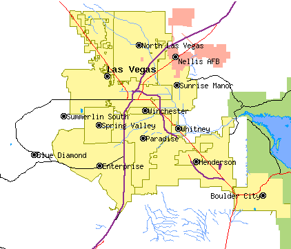
The Las Vegas Valley is a major metropolitan area in the Southern Nevada, southern part of the U.S. state of Nevada, and the second largest in the Southwestern United States. The state's largest urban agglomeration, the Las Vegas Metropolitan Statistical Area is coextensive since 2003 with Clark County, Nevada, Clark County, Nevada. The Valley is largely defined by the Las Vegas Valley landform, a Depression (geology), basin area surrounded by mountains to the north, south, east and west of the metropolitan area. The Valley is home to the three largest incorporated cities in Nevada: Las Vegas, Henderson, Nevada, Henderson and North Las Vegas, Nevada, North Las Vegas. Eleven unincorporated towns governed by the Clark County government are part of the Las Vegas Township and constitute the largest community in the state of Nevada. The names Las Vegas and Vegas are interchangeably used to indicate the Valley, Las Vegas Strip, the Strip, and the city, and as a brand by the Las Vegas Co ... [...More Info...] [...Related Items...] OR: [Wikipedia] [Google] [Baidu] |


.png)
