|
Lists Of 21st-century Earthquakes
The following is a summary of significant earthquakes during the 21st century. In terms of fatalities, the 2004 Indian Ocean earthquake was the most destructive event with around 227,898 fatalities, followed by the 2010 Haiti earthquake with 160,000 fatalities, 2005 Kashmir earthquake 87,351 fatalities and 2008 Sichuan earthquake with 87,587 fatalities. The 2011 Tōhoku earthquake and tsunami became the costliest natural disaster, resulting in approximately $360 billion in property damage at the time, followed by the 2008 Sichuan earthquake which resulted at least $150 billion in damage. List of deadliest earthquakes * Note: At least 1,000+ fatalities List of largest earthquakes by magnitude * Note: At least 8.5+ magnitude List of costliest earthquakes Note:This only ranks immediate costs, for example, nuclear meltdown and climate and fossil fuel costs, as well as other ongoing costs from quakes are not included. Deadliest earthquakes by year These are the deadliest ... [...More Info...] [...Related Items...] OR: [Wikipedia] [Google] [Baidu] |
USGS Magnitude 8 Earthquakes Since 1900
The United States Geological Survey (USGS), formerly simply known as the Geological Survey, is a scientific agency of the United States government. The scientists of the USGS study the landscape of the United States, its natural resources, and the natural hazards that threaten it. The organization's work spans the disciplines of biology, geography, geology, and hydrology. The USGS is a fact-finding research organization with no regulatory responsibility. The agency was founded on March 3, 1879. The USGS is a bureau of the United States Department of the Interior; it is that department's sole scientific agency. The USGS employs approximately 8,670 people and is headquartered in Reston, Virginia. The USGS also has major offices near Lakewood, Colorado, at the Denver Federal Center, and Menlo Park, California. The current motto of the USGS, in use since August 1997, is "science for a changing world". The agency's previous slogan, adopted on the occasion of its hundredth anniversa ... [...More Info...] [...Related Items...] OR: [Wikipedia] [Google] [Baidu] |
Yahoo! News
Yahoo! News is a news website that originated as an internet-based news aggregator by Yahoo!. The site was created by a Yahoo! software engineer named Brad Clawsie in August 1996. Articles originally came from news services such as the Associated Press, Reuters, Fox News, Al Jazeera, ABC News, ''USA Today'', CNN and BBC News. In 2001, Yahoo! News launched the first "most-emailed" page on the web. It was well-received as an innovative idea, expanding people's understanding of the impact that online news sources have on news consumption. Yahoo allowed comments for news articles until December 19, 2006, when commentary was disabled. Comments were re-enabled on March 2, 2010. By 2011, Yahoo had expanded its focus to include original content, as part of its plans to become a major media organization. Veteran journalists (including Walter Shapiro and Virginia Heffernan) were hired, while the website had a correspondent in the White House press corps for the first time in February 2012 ... [...More Info...] [...Related Items...] OR: [Wikipedia] [Google] [Baidu] |
2011 Christchurch Earthquake
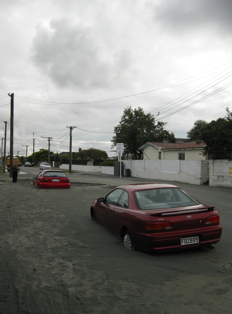
A major earthquake occurred in Christchurch on Tuesday 22 February 2011 at 12:51 p.m. local time (23:51 UTC, 21 February). The () earthquake struck the entire of the Canterbury region in the South Island, centred south-east of the central business district. It caused widespread damage across Christchurch, killing 185 people, in New Zealand's fifth-deadliest disaster. Christchurch's central city and eastern suburbs were badly affected, with damage to buildings and infrastructure already weakened by the magnitude 7.1 Canterbury earthquake of 4 September 2010 and its aftershocks. Significant liquefaction affected the eastern suburbs, producing around 400,000 tonnes of silt. The earthquake was felt across the South Island and parts of the lower and central North Island. While the initial quake only lasted for approximately 10 seconds, the damage was severe because of the location and shallowness of the earthquake's focus in relation to Christchurch as well as ... [...More Info...] [...Related Items...] OR: [Wikipedia] [Google] [Baidu] |
United States Dollar
The United States dollar ( symbol: $; code: USD; also abbreviated US$ or U.S. Dollar, to distinguish it from other dollar-denominated currencies; referred to as the dollar, U.S. dollar, American dollar, or colloquially buck) is the official currency of the United States and several other countries. The Coinage Act of 1792 introduced the U.S. dollar at par with the Spanish silver dollar, divided it into 100 cents, and authorized the minting of coins denominated in dollars and cents. U.S. banknotes are issued in the form of Federal Reserve Notes, popularly called greenbacks due to their predominantly green color. The monetary policy of the United States is conducted by the Federal Reserve System, which acts as the nation's central bank. The U.S. dollar was originally defined under a bimetallic standard of (0.7735 troy ounces) fine silver or, from 1837, fine gold, or $20.67 per troy ounce. The Gold Standard Act of 1900 linked the dollar solely to gold. From 1934, it ... [...More Info...] [...Related Items...] OR: [Wikipedia] [Google] [Baidu] |
September 2007 Sumatra Earthquakes
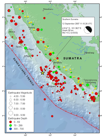
The September 2007 Sumatra earthquakes were a series of megathrust earthquakes that struck the Sunda Trench off the coast of Sumatra, Indonesia, with three of magnitude 7 or greater. A series of tsunami bulletins was issued for the area. The most powerful of the series had a magnitude of 8.5, which makes it in the top 20 of the largest earthquakes ever recorded on a seismograph. Timeline The first earthquake occurred at 11:10:26 UTC (18:10 local time) on 12 September 2007, and was an 8.5 earthquake on the moment magnitude scale. It had a focal depth of 34 km, at , about 130 km southwest of Bengkulu on the southwest coast of Sumatra, Indonesia, and some 600 km west-northwest of Indonesia's capital city, Jakarta. It was followed by several earthquakes of magnitude 5 through 6 along the same fault, west of Sumatra. The second largest earthquake, 7.9 Mw, occurred later the same day at 23:49:04 UTC (06:49:04 local time the following day). It was centred ... [...More Info...] [...Related Items...] OR: [Wikipedia] [Google] [Baidu] |
2012 Indian Ocean Earthquakes
The 2012 Indian Ocean earthquakes were magnitude 8.6 and 8.2 undersea earthquakes that struck near the Indonesian province of Aceh on 11 April at 15:38 local time. Initially, authorities feared that the initial earthquake would cause a tsunami and warnings were issued across the Indian Ocean; however, these warnings were subsequently cancelled. These were unusually strong intraplate earthquakes and the largest strike-slip earthquake ever recorded. Tectonic setting The 2012 earthquake's epicenter was located within the Indo-Australian Plate, which is divided into two sub- or proto-plates: the Indian, and Australian. At their boundary, the Indian and Australian Plates converge at per year in a NNW–SSE direction. This convergence is accommodated by a broad zone of diffuse deformation. As part of that intraplate deformation, north–south trending fracture zones have been reactivated from the Ninety East Ridge as far east as 97°E. The Indo–Australian Plate was formed afte ... [...More Info...] [...Related Items...] OR: [Wikipedia] [Google] [Baidu] |
Maule Region
The Maule Region ( es, Región del Maule, ) is one of Chile's 16 first order administrative divisions. Its capital is Talca. The region derives its name from the Maule River which, running westward from the Andes, bisects the region and spans a basin of about 20,600 km2. The Maule river is of considerable historic interest because, among other reasons, it marked the southern limits of the Inca Empire. Geography and ecology The region covers an area of and is bordered on the west by the Pacific Ocean; on the east by the Argentina; on the north by the O'Higgins Region, and on the south by the Ñuble Region. There are a number of flora and fauna species present in Maule. For example, the endangered Chilean Wine Palm (''Jubaea chilensis'') is found in a very limited distribution that includes the Maule Region. The limited distribution ''Nothofagus alessandri'' is also found in the region. Demography According to the 2017 census, the population of the region was 1,033,197. Wi ... [...More Info...] [...Related Items...] OR: [Wikipedia] [Google] [Baidu] |
2010 Chile Earthquake
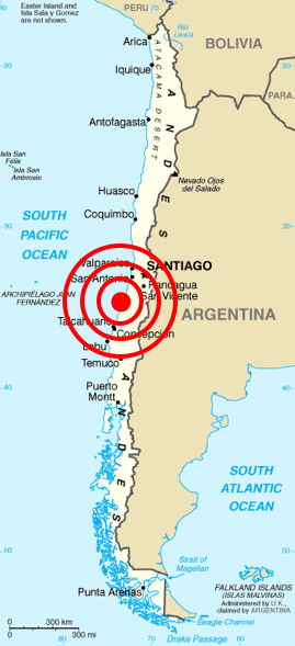
The 2010 Chile earthquake and tsunami ( es, Terremoto del 27F) occurred off the coast of central Chile on Saturday, 27 February at 03:34 local time (06:34 UTC), having a magnitude of 8.8 on the moment magnitude scale, with intense shaking lasting for about three minutes. It was felt strongly in six Chilean regions (from Valparaíso in the north to Araucanía in the south) that together make up about 80 percent of the country's population. According to the United States Geological Survey (USGS) the cities experiencing the strongest shaking—VIII (''Severe'') on the Mercalli intensity scale (MM)—were Concepción, Arauco, and Coronel. According to Chile's Seismological Service, Concepción experienced the strongest shaking at MM IX (''Violent''). The earthquake was felt in the capital Santiago at MM VII (''Very strong'') or MM VIII. Tremors were felt in many Argentine cities, including Buenos Aires, Córdoba, Mendoza, and La Rioja. Tremors were felt as far north as the ... [...More Info...] [...Related Items...] OR: [Wikipedia] [Google] [Baidu] |
Pacific Ocean
The Pacific Ocean is the largest and deepest of Earth's five oceanic divisions. It extends from the Arctic Ocean in the north to the Southern Ocean (or, depending on definition, to Antarctica) in the south, and is bounded by the continents of Asia and Oceania in the west and the Americas in the east. At in area (as defined with a southern Antarctic border), this largest division of the World Ocean—and, in turn, the hydrosphere—covers about 46% of Earth's water surface and about 32% of its total surface area, larger than Earth's entire land area combined .Pacific Ocean . '' Britannica Concise.'' 2008: Encyclopædia Britannica, Inc. The centers of both the |
Tōhoku Region
The , Northeast region, or consists of the northeastern portion of Honshu, the largest island of Japan. This traditional region consists of six prefectures (''ken''): Akita, Aomori, Fukushima, Iwate, Miyagi, and Yamagata. Tōhoku retains a reputation as a remote, scenic region with a harsh climate. In the 20th century, tourism became a major industry in the Tōhoku region. History Ancient & Classical period In mythological times, the area was known as Azuma (吾妻, あづま) and corresponded to the area of Honshu occupied by the native Emishi and Ainu. The area was historically the Dewa and the Michinoku regions, a term first recorded in (654). There is some variation in modern usage of the term "Michinoku". Tōhoku's initial historical settlement occurred between the seventh and ninth centuries, well after Japanese civilization and culture had become firmly established in central and southwestern Japan. The last stronghold of the indigenous Emishi on Honshu and ... [...More Info...] [...Related Items...] OR: [Wikipedia] [Google] [Baidu] |
Sumatra
Sumatra is one of the Sunda Islands of western Indonesia. It is the largest island that is fully within Indonesian territory, as well as the sixth-largest island in the world at 473,481 km2 (182,812 mi.2), not including adjacent islands such as the Simeulue, Nias, Mentawai, Enggano, Riau Islands, Bangka Belitung and Krakatoa archipelago. Sumatra is an elongated landmass spanning a diagonal northwest–southeast axis. The Indian Ocean borders the northwest, west, and southwest coasts of Sumatra, with the island chain of Simeulue, Nias, Mentawai, and Enggano off the western coast. In the northeast, the narrow Strait of Malacca separates the island from the Malay Peninsula, which is an extension of the Eurasian continent. In the southeast, the narrow Sunda Strait, containing the Krakatoa Archipelago, separates Sumatra from Java. The northern tip of Sumatra is near the Andaman Islands, while off the southeastern coast lie the islands of Bangka and Belitung, Karim ... [...More Info...] [...Related Items...] OR: [Wikipedia] [Google] [Baidu] |
2009 Sumatra Earthquakes
The first of the 2009 Sumatra earthquakes ( id, Gempa bumi Sumatra 2009) occurred on 30 September off the coast of Sumatra, Indonesia with a moment magnitude of 7.6 at . The epicenter was west-northwest of Padang, West Sumatra, and southwest of Pekanbaru, Riau. Government and authorities confirmed 1,115 dead, 1,214 severely injured and 1,688 slightly injured. The most deaths occurred in the areas of Padang Pariaman (675), Padang (313), Agam (80) and Pariaman (37). In addition, around 135,000 houses were severely damaged, 65,000 houses were moderately damaged and 79,000 houses were slightly damaged. An estimated 250,000 families (1,250,000 people) have been affected by the earthquake through the total or partial loss of their homes and livelihoods.http://www.reliefweb.int/rw/rwb.nsf/db900SID/EDIS-7WSKEP Tectonic setting Many of Indonesia's islands, including Sumatra, are situated within a zone of high seismic activity known as the Ring of Fire. Along the Sunda megathrust, t ... [...More Info...] [...Related Items...] OR: [Wikipedia] [Google] [Baidu] |


.jpg)


