|
List Of Twin Towns And Sister Cities In The Republic Of Artsakh
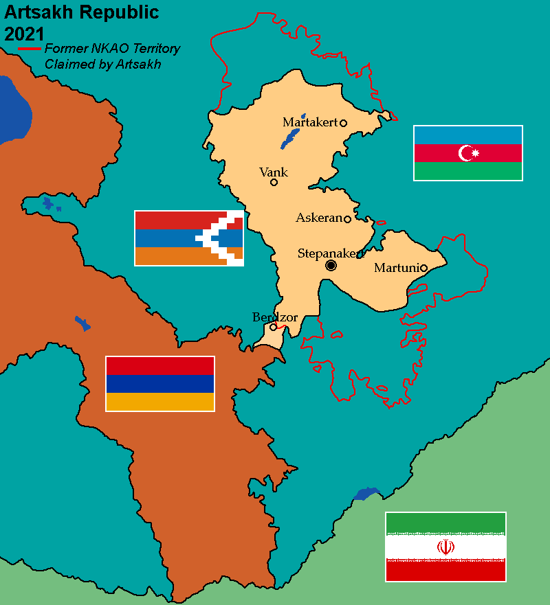
This is a list of places in the ''de facto'' Republic of Artsakh which have standing links to local communities in other countries known as "town twinning" (usually in Europe) or "sister cities" (usually in the rest of the world). L Lachin * Highland, United States M Martakert * Vagarshapat, Armenia Martuni * Les Pennes-Mirabeau, France S Stepanakert * Franco da Rocha, Brazil * Mairiporã, Brazil * Montebello, United States References {{Twin towns Nagorno-Karabakh Republic Azerbaijan Nagorno-Karabakh Republic Azerbaijan Azerbaijan (, ; az, Azərbaycan ), officially the Republic of Azerbaijan, , also sometimes officially called the Azerbaijan Republic is a transcontinental country located at the boundary of Eastern Europe and Western Asia. It is a part of th ... Republic of Artsakh-related lists Cities and towns in the Republic of Artsakh ... [...More Info...] [...Related Items...] OR: [Wikipedia] [Google] [Baidu] |
Republic Of Artsakh
Artsakh, officially the Republic of Artsakh () or the Nagorno-Karabakh Republic (),, is a list of states with limited recognition, breakaway state in the South Caucasus whose territory is internationally recognised as part of Azerbaijan. Artsakh controls a part of the former Nagorno-Karabakh Autonomous Oblast, including the capital of Stepanakert. It is an Enclave and exclave, enclave within Azerbaijan. Its only overland access route to Armenia is via the wide Lachin corridor which is under the control of Russian peacekeepers. The predominantly Armenian-populated region of Nagorno-Karabakh was claimed by both the Azerbaijan Democratic Republic and the First Republic of Armenia when both countries became independent in 1918 after the fall of the Russian Empire, and a brief war over the region broke out in 1920. The dispute was largely shelved after the Soviet Union established control over the area, and created the Nagorno-Karabakh Autonomous Oblast (NKAO) within the Aze ... [...More Info...] [...Related Items...] OR: [Wikipedia] [Google] [Baidu] |
Sister City
A sister city or a twin town relationship is a form of legal or social agreement between two geographically and politically distinct localities for the purpose of promoting cultural and commercial ties. While there are early examples of international links between municipalities akin to what are known as sister cities or twin towns today dating back to the 9th century, the modern concept was first established and adopted worldwide during World War II. Origins of the modern concept The modern concept of town twinning has its roots in the Second World War. More specifically, it was inspired by the bombing of Coventry on 14 November 1940, known as the Coventry Blitz. First conceived by the then Mayor of Coventry, Alfred Robert Grindlay, culminating in his renowned telegram to the people of Stalingrad (now Volgograd) in 1942, the idea emerged as a way of establishing solidarity links between cities in allied countries that went through similar devastating events. The comradesh ... [...More Info...] [...Related Items...] OR: [Wikipedia] [Google] [Baidu] |
Lachin
Lachin ( az, Laçın, , ; hy, Բերձոր, translit=Berdzor; ku, Laçîn) is a town in Azerbaijan and the administrative center of the Lachin District. It is located within the strategic Lachin corridor, which links the disputed region of Nagorno-Karabakh with Armenia. The town was occupied by Armenian forces in 1992, during the First Nagorno-Karabakh War, and its local Azerbaijani and Kurdish population was expelled, while Armenians settled in. The town came under the ''de facto'' control of the breakaway Republic of Artsakh, administrated as part of its Kashatagh Province. It came under the supervision of the Russian peacekeeping force following the ceasefire agreement that ended the 2020 Nagorno-Karabakh war. Lachin and the villages of Sus and Zabukh returned under Azerbaijan's control on 26 August 2022. History Early history Cuneiform inscriptions dating back to the Urartian period have been found in the caves surrounding the town. The area was first mentioned ... [...More Info...] [...Related Items...] OR: [Wikipedia] [Google] [Baidu] |
Highland, California
Highland (and neighboring "East Highlands") is a city in San Bernardino County, California, United States. The population of the city was 53,104 as of the 2010 census, up from 44,605 at the 2000 census. The term ''Highland'' also refers to a geographical area of the city of San Bernardino (generally east of Del Rosa Avenue to the eastern city limits), and parts of unincorporated San Bernardino County. Highland is generally divided into two regions, East Highlands and Highland (Generally considered west of State Route 210, with the majority of inhabitants living east of the freeway.) Geography Highland is located at (34.118459, -117.202370). According to the United States Census Bureau, the city has a total area of 18.9 square miles (48.9 km). 18.8 square miles (48.6 km) of it is land and 0.1 square miles (0.3 km) of it (0.71%) is water. Demographics 2010 At the 2010 census Highland had a population of 53,104. The population density was . The racial makeup o ... [...More Info...] [...Related Items...] OR: [Wikipedia] [Google] [Baidu] |
Martakert
Martakert ( hy, Մարտակերտ, also , ) or Aghdara ( az, Ağdərə ) is a town ''de facto'' in the breakaway Republic of Artsakh as the administrative capital of its Martakert Province, ''de jure'' in the Tartar District of Azerbaijan, in the disputed region of Nagorno-Karabakh. The town has an ethnic Armenian-majority population, and also had an Armenian majority in 1989. The town underwent heavy destruction by Azerbaijani forces while under their control during the First Nagorno-Karabakh War. Etymology Traditionally the name of the town is interpreted as consisting of the elements ''mard'' ("man, person," or in this context "brave") and ''kert'' ("built by"), supposedly referring to the inhabitants' reputation for bravery.'''' Other explanations link the name with the word ''matuṛ'' ("chapel").'''' The Azerbaijani name for the settlement, Aghdara, translates to "white valley." History The site of the settlement was historically a part of the Melikdom of Jraberd, ... [...More Info...] [...Related Items...] OR: [Wikipedia] [Google] [Baidu] |
Vagharshapat, Armenia
Vagharshapat ( hy, Վաղարշապատ ) is the 4th-largest city in Armenia and the most populous municipal community of Armavir Province, located about west of the capital Yerevan, and north of the closed Turkish-Armenian border. It is commonly known as Ejmiatsin (also spelled Echmiadzin or Etchmiadzin, , ), which was its official name between 1945 and 1995. It is still commonly used colloquially and in official bureaucracy (dual naming). The city is best known as the location of Etchmiadzin Cathedral and Mother See of Holy Etchmiadzin, the center of the Armenian Apostolic Church. It is thus unofficially known in Western sources as a "holy city" and in Armenia as the country's "spiritual capital" (). It was one of the major cities and a capital of the ancient Kingdom of Greater Armenia. Reduced to a small town by the early 20th century, it experienced large expansion during the Soviet period becoming, effectively, a suburb of Yerevan. Its population stands just over 37, ... [...More Info...] [...Related Items...] OR: [Wikipedia] [Google] [Baidu] |
Martuni (town)
Martuni ( hy, Մարտունի) or Khojavend ( az, Xocavənd ) is a town ''de facto'' in the breakaway Republic of Artsakh as the centre of its Martuni Province, and the ''de jure'' centre of the Khojavend District of Azerbaijan, in the disputed region of Nagorno-Karabakh. It is approximately 41 kilometers east of the regional capital, Stepanakert. It has a population of 5,700 as of 2015. The town has an ethnic Armenian-majority population, and also had an Armenian majority in 1989. Etymology The name ''Martuni'' originates from the '' nom de guerre'' of Armenian Bolshevik revolutionary and official Alexander Miasnikian. The name ''Khojavend'' is of Persian origin. History Excavations in the settlement have uncovered a number of tombs dating to the Neolithic and Bronze Ages. Martuni is also home to several ruined medieval churches and remains of settlements, and '' khachkars'' have also been preserved. Anon. ''«Մարտունի»'' (Martuni). Armenian Soviet Encycloped ... [...More Info...] [...Related Items...] OR: [Wikipedia] [Google] [Baidu] |
Les Pennes-Mirabeau
Les Pennes-Mirabeau (; oc, Lei Penas de Mirabèu) is a commune in the Bouches-du-Rhône department in southern France, located 13.5 km (8.4 mi) from Marseille. In May every year, a medieval festival attracts tens of thousands people. Population Twin towns – sister cities Les Pennes-Mirabeau is twinned with: * Martuni (Khojavend), Nagorno-Karabakh: Les Pennes-Mirabeau and Martuni became sister cities on 11 June 2013. See also *Communes of the Bouches-du-Rhône department The following is a list of the 119 communes of the Bouches-du-Rhône department of France. The communes cooperate in the following intercommunalities (as of 2020):Official website (in French) ... [...More Info...] [...Related Items...] OR: [Wikipedia] [Google] [Baidu] |
Stepanakert
/ az, Xankəndi, italic=no , settlement_type = City , image_skyline = File:StepanakertCollage.jpg , imagesize = 300px , image_caption = From top left: Holy Mother of God Cathedral Renaissance Square • Downtown Stepanakert Stepanakert Airport • Stepanakert skyline Park Hotel Artsakh • ''We Are Our Mountains'' Artsakh University • Stepanakert Memorial , image_flag = Flag of Stepanakert, Artsakh.svg , shield_size = 75px , map_caption = Location of Stepanakert in Artsakh and in Azerbaijan. , pushpin_map = Republic of Artsakh#Azerbaijan , subdivision_type = Country , subdivision_name = Artsakh , subdivision_type1 = Province , subdivision_name1 = Stepanakert , subdivision_type2 = Country , subdivision_name2 ... [...More Info...] [...Related Items...] OR: [Wikipedia] [Google] [Baidu] |
Franco Da Rocha
Franco da Rocha is a municipality in the state of São Paulo. It is part of the Metropolitan Region of São Paulo. The population is 156,492 (2020 est.) in an area of 132.78 km². The suburban city is served by CPTM Line 7 (Ruby). The municipality contains the Juqueri State Park, created in 1993. In February 2016, the municipality signed a Friendship Declaration with Stepanakert, the capital of the partially independent Republic of Artsakh Artsakh, officially the Republic of Artsakh () or the Nagorno-Karabakh Republic (),, is a list of states with limited recognition, breakaway state in the South Caucasus whose territory is internationally recognised as part of Azerbaijan .... References External links *EncontraFrancodaRocha - Por toda la ciudad de Franco da Rocha Municipalities in São Paulo (state) {{SaoPauloState-geo-stub ... [...More Info...] [...Related Items...] OR: [Wikipedia] [Google] [Baidu] |
Mairiporã
Mairiporã is a Brazilian municipality in São Paulo state. It is part of the São Paulo metropolitan area. The population is 101,937 (2020 est.) in an area of 321 km². History It became a municipality in 1889, separating from Guarulhos, it was named "Juqueri", and it comprised also what today are the cities of Franco da Rocha, Caieiras and Francisco Morato. The current name was adopted in December 1948, and means "beautiful city" (''mairy'': village, city + ''poranga'': beautiful). Geography Mairiporã is situated at an average altitude of 790m. The highest points of Mairiporã are in Serra da Cantareira, where it reaches an altitude of over 1100m in some areas. Climate: Like in all of the São Paulo metropolitan area, the climate is subtropical. Summer is considerably warm and rainy while the winter is mild. The average annual temperature is about 18 °C. The coldest month is July with an average 14 °C and the warmest February with an average 22 °C. Th ... [...More Info...] [...Related Items...] OR: [Wikipedia] [Google] [Baidu] |

.jpg)


