|
List Of National Parks Of Pakistan
Pakistan has 36 national parks ( ur, ). As of 2012, 25 of these are under supervision of respective provincial governments and remaining are in private care. Only some of these are under the conservation scope of International Union for Conservation of Nature. Protection and conservation of the environment of Pakistan was included in the concurrent constitution of 1973. As a result, ''Environment Protection Ordinance'' was enacted in 1983, which was mainly regulated by the Environment and Urban Affairs Division. Later, a new system of 'Modern Protected Areas' legislation began at the provincial level which assigned the protected areas with designations such as national parks, wildlife sanctuaries and game reserves. Further recommendations of the national parks of the Indomalayan realm were highlighted in the IUCN review of 1986. Nevertheless, the development of national parks was mainly carried out by National Conservation Strategy of 1992. Due to more awareness about their im ... [...More Info...] [...Related Items...] OR: [Wikipedia] [Google] [Baidu] |
Pakistan
Pakistan ( ur, ), officially the Islamic Republic of Pakistan ( ur, , label=none), is a country in South Asia. It is the world's List of countries and dependencies by population, fifth-most populous country, with a population of almost 243 million people, and has the world's Islam by country#Countries, second-largest Muslim population just behind Indonesia. Pakistan is the List of countries and dependencies by area, 33rd-largest country in the world by area and 2nd largest in South Asia, spanning . It has a coastline along the Arabian Sea and Gulf of Oman in the south, and is bordered by India to India–Pakistan border, the east, Afghanistan to Durand Line, the west, Iran to Iran–Pakistan border, the southwest, and China to China–Pakistan border, the northeast. It is separated narrowly from Tajikistan by Afghanistan's Wakhan Corridor in the north, and also shares a maritime border with Oman. Islamabad is the nation's capital, while Karachi is its largest city and fina ... [...More Info...] [...Related Items...] OR: [Wikipedia] [Google] [Baidu] |
Districts Of Pakistan
The Districts of Pakistan ( ur, ); are the third-order administrative divisions of Pakistan, below provinces and divisions, but forming the first-tier of local government. In total, there are 169 districts in Pakistan including the Capital Territory and the districts of Azad Kashmir and Gilgit Baltistan. These districts are further divided into ''Tehsils, Union Councils''. History In 1947, when Pakistan gained independence there were 124 districts. In 1969, 2 new districts (Tangail and Patuakhali) in East Pakistan were formed totalling to 126. After the Independence of Bangladesh, Pakistan lost 20 of its districts and so there were 106 districts. In 2001, the number was reduced to 102 by the merger of the 5 districts of Karachi Central, Karachi East, Karachi South, Karachi West and Malir to form Karachi District. The number of districts rose to 106 again in December 2004, when four new districts were created in the province of Sindh of which one (Umerkot) had existed until ... [...More Info...] [...Related Items...] OR: [Wikipedia] [Google] [Baidu] |
Chinji National Park
Chinji National Park (shortened as Chinji), established in 1987, is a protected area of IUCN category II ( national park) located on Sargodha road in Talagang Tehsil, Chakwal District, Punjab, Pakistan. It covers a total area of . Chinji National Park is located close to Salt Range, about 130 km from Islamabad in the south. Landscape The area has an elevation imperial of 2,231 feet (680 m). Deeply eroded land of Chinji consists of sandstone to igneous rocks, combined with small deposits of rock salt from the Salt Range. Deep torrential streams and ravines slope into the Soan River, which passes through the area. Climate Average annual rainfall in the area is 537 mm, out of which 308 mm is in the monsoon season from July to September. Maximum temperature is 27 °C in June and minimum is 2.2 °C in January. Frost is common in winter season. Relative humidity can reach up to 80% in monsoon. Wildlife The Chinji National Park exhibits the biome of deserts ... [...More Info...] [...Related Items...] OR: [Wikipedia] [Google] [Baidu] |
Shigar District
Shigar District ( ur, ) is one of the 14 districts of Pakistani territory of Gilgit-Baltistan. The district is bounded on the north by the Nagar District, the Hunza District, and the Kashgar Prefecture of China's Xinjiang Uyghur Autonomous Region, on the south-east by the Ghanche District, on the south-west by the Rondu District and the Skardu District, and on the west by the Gilgit District. The Shigar District was established in 2015, prior to which time it had been part of the Skardu District. The headquarters of the Shigar District is the town of Shigar, which is from the city of Skardu , nickname = , motto = , image_skyline = , map_caption = , pushpin_map = Gilgit Baltistan#Pakistan , pushpin_label_position .... The district is home to the world's second-highest peak, K2. References Districts of Gilgit-Baltistan {{Pakistan-geo-s ... [...More Info...] [...Related Items...] OR: [Wikipedia] [Google] [Baidu] |
Khyber Pakhtunkhwa
Khyber Pakhtunkhwa (; ps, خېبر پښتونخوا; Urdu, Hindko: خیبر پختونخوا) commonly abbreviated as KP or KPK, is one of the Administrative units of Pakistan, four provinces of Pakistan. Located in the Geography of Pakistan, northwestern region of the country, Khyber Pakhtunkhwa is the smallest province of Pakistan by land area and the Demographics of Pakistan, third-largest province by population after Punjab, Pakistan, Punjab and Sindh. It shares land borders with the Pakistani provinces of Balochistan, Pakistan, Balochistan to the south, Punjab, Pakistan, Punjab to the south-east and province of Gilgit-Baltistan to the north and north-east, as well as Islamabad Capital Territory to the east, Azad Jammu and Kashmir, Autonomous Territory of Azad Jammu and Kashmir to the north-east. It shares an Durand Line, international border with Afghanistan to the west. Khyber Pakhtunkhwa is known as a tourist hot spot for adventurers and explorers and has a varied landsca ... [...More Info...] [...Related Items...] OR: [Wikipedia] [Google] [Baidu] |
Chitral District
Chitral District ( ur, ) was the largest district in the Khyber-Pakhtunkhwa province of Pakistan, covering an area of 14,850 km², before splitting into Upper Chitral District and Lower Chitral District in 2018. Part of the Malakand Division, it is the northernmost district of Pakistan. It shares a border with Gilgit-Baltistan to the east, with Kunar, Badakshan and Nuristan provinces of Afghanistan to the north and west, and with the Khyber-Pakhtunkhwa districts of Swat and Dir to the south. A narrow strip of Wakhan Corridor separates Chitral from Tajikistan in the north. History Chitral shares much of its history and culture with the neighboring Hindu Kush territories of Gilgit-Baltistan, a region sometimes called "Peristan" because of the common belief in fairies (''peri'') inhabiting the high mountains. The entire region that now forms the Chitral District was an independent monarchical state until 1895, when the British negotiated a treaty with its hereditary ... [...More Info...] [...Related Items...] OR: [Wikipedia] [Google] [Baidu] |
Broghil Valley National Park
Broghil Valley National Park ( ur, بروغل) is located in the upper northern reaches of the Chitral District, Khyber Pakhtunkhwa, Pakistan, close to the Afghan-Pakistan border. Geography Broghil Valley is from the main town of Chitral and is the northernmost valley within the Chitral district. Broghil valley borders on the Afghan Wakhan corridor, which stretches between Tajikistan and Pakistan. The area is mostly mountainous. Elevations range from between at the village of Kishmanjah to at Karambar Lake in the northeast. The terrain is undulating with mountains, grassy plains, and valleys. It includes almost 3,400 ha of peatlands and lakes.Hydrological assessment of significant lakes in Broghil and Qurumbar Valleys, Northern Alpine Wetlands Complex. The valley features around 30 freshwater lakes and is surrounded by glaciers and mountains. Tourism The Broghil valley’s remote location makes it a hard-to-reach tourist destination. Many communities in Broghil lack ac ... [...More Info...] [...Related Items...] OR: [Wikipedia] [Google] [Baidu] |
Gupis-Yasin District
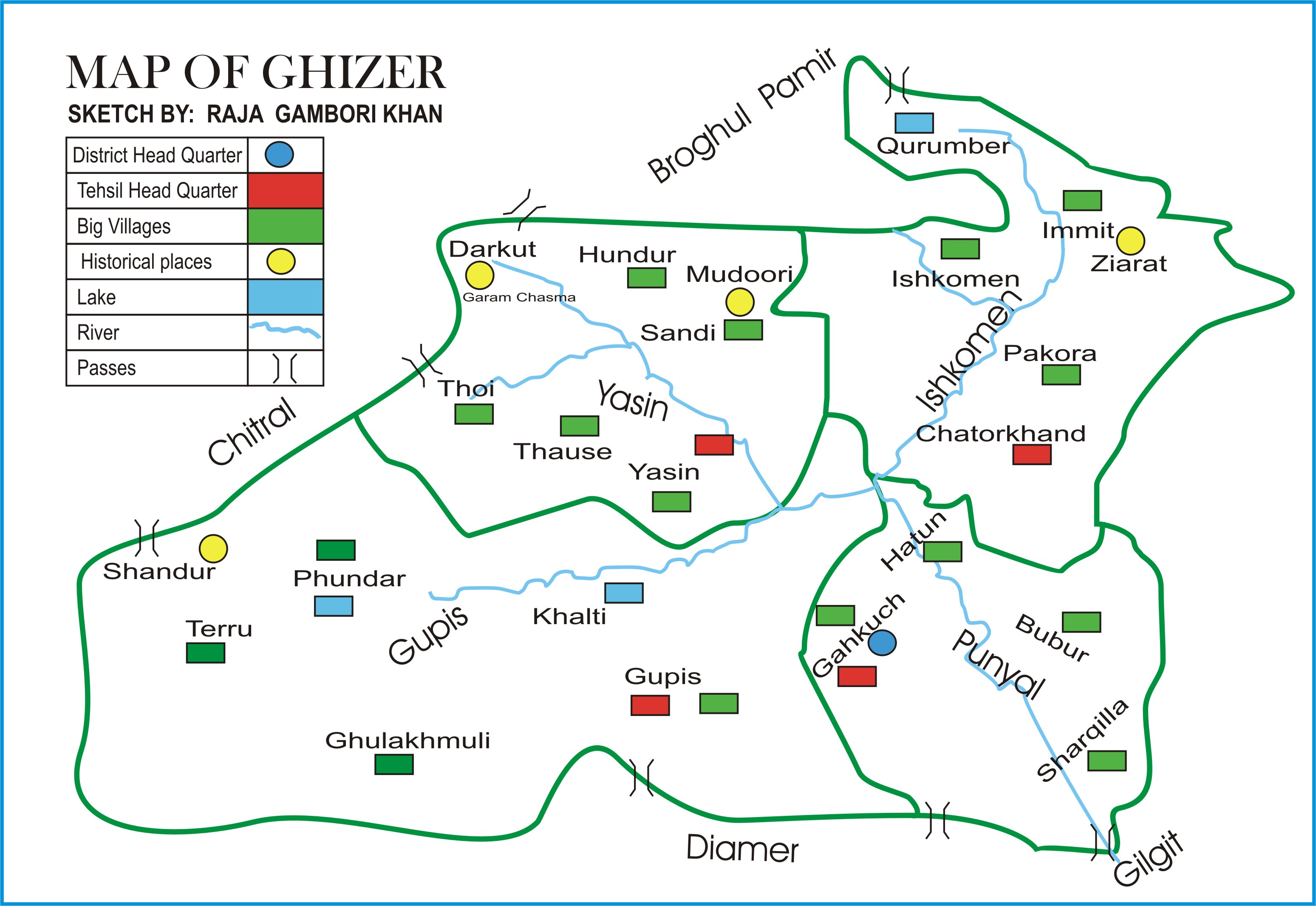
The Gupis-Yasin District ( ur, ) is the westernmost district of the 14 districts of Pakistan-administered territory of Gilgit-Baltistan. The Gupis-Yasin District was created in 2019 from the Gupis Tehsil and the Yasin Tehsil, which were the two western tehsils of the former, larger Ghizer District. Geography The Gupis-Yasin District is bounded on the north and west by the Upper Chitral District of Pakistan's Khyber Pakhtunkhwa Province, on the east by the Ghizer District, on the south by the Swat District of Pakistan's Khyber Pakhtunkhwa Province and the Upper Kohistan District of Pakistan's Khyber Pakhtunkhwa Province. The map of the former Ghizer District shows the Yasin Tehsil and the former, larger Gupis Tehsil, which was subsequently divided into two tehsils: the present, smaller Gupis Tehsil and the Phander Tehsil. The present Ghizer District consists of the Ishkoman Tehsil and the Punial Tehsil. Administration The Gupis-Yasin District consists of three tehsils: ... [...More Info...] [...Related Items...] OR: [Wikipedia] [Google] [Baidu] |
Gilgit Baltistan
Gilgit (; Shina language, Shina: ; ur, ) is the capital city of Gilgit-Baltistan, Gilgit–Baltistan, Pakistan. The city is located in a broad valley near the confluence of the Gilgit River and the Hunza River. It is a major Tourism in Pakistan, tourist destination in Pakistan, serving as a hub for Backpacking (hiking), trekking and mountaineering expeditions in the Karakoram mountain range. Gilgit was once a major centre for Buddhism; it was an important stop on the ancient Silk Road, and today serves as a major junction along the Karakoram Highway with road connections to China as well as the Pakistani cities of Skardu, Chitral, Peshawar, and Islamabad. Currently, it serves as a frontier station for the local tribal areas. The city's economic activity is mainly focused on agriculture, with wheat, maize, and barley as the mainly-produced crops. Etymology The city's ancient name was ''Sargin'', later to be known as ''Gilit'', and it is still referred to as ''Gilit'' or ''Sa ... [...More Info...] [...Related Items...] OR: [Wikipedia] [Google] [Baidu] |
Astore District
Astore District ( ur, ) is one of the 14 districts of the Pakistani-administered territory of Gilgit−Baltistan. Its administrative headquarters are located at Eidgah in the Astore Valley. The Astore District is bounded by Gilgit District to the north, Roundu District to the northeast, Skardu District to the east, Kharmang District to the southeast, Diamer District to the west, the Neelum District of Azad Jammu and Kashmir to the southwest, and the Bandipore District of Indian-administered Jammu and Kashmir to the south. Astore Valley The Astore Valley has an area of 5,092 km² and is at an altitude of . The valley has approximately of glacier cover. The nearest glacier after entering the valley is the Harcho Glacier, and the most accessible glacier is the Siachen Glacier. Accessibility Eidgah is connected to Gilgit, which is well connected by air with Islamabad and by road with Peshawar, Swat, Islamabad-Rawalpindi, Chitral, and Skardu. There are two ways of acc ... [...More Info...] [...Related Items...] OR: [Wikipedia] [Google] [Baidu] |

_20.jpg)


