|
List Of Lighthouses In Hawaii
This is a list of lighthouses in Hawaii. Fifteen lighthouses in Hawaii are associated with the U.S. Coast Guard. Including minor lights, there are 43 lights in total. Lighthouses Minor Lights There are over 30 "minor lights" in Hawaii, most if not all of them are on beacons or poles. The "Year built" column only represents the most recent structure, all of the lights listed below are active unless noted otherwise. Complete data for any given light may be unavailable due to poor record keeping, or lack details from reliable sources. See also * List of lighthouses in the United States * Lists of lighthouses and lightvessels References External linksLighthouseFriends.Com's list of Hawaii lighthouses {{Oceania topic, List of lighthouses in Hawaii Lighthouses * Lighthouses A lighthouse is a tower, building, or other type of physical structure designed to emit light from a system of lamps and lenses and to serve as a beacon for navigational aid, for maritime pilots a ... [...More Info...] [...Related Items...] OR: [Wikipedia] [Google] [Baidu] |
Lighthouse
A lighthouse is a tower, building, or other type of physical structure designed to emit light from a system of lamps and lenses and to serve as a beacon for navigational aid, for maritime pilots at sea or on inland waterways. Lighthouses mark dangerous coastlines, hazardous shoals, reefs, rocks, and safe entries to harbors; they also assist in aerial navigation. Once widely used, the number of operational lighthouses has declined due to the expense of maintenance and has become uneconomical since the advent of much cheaper, more sophisticated and effective electronic navigational systems. History Ancient lighthouses Before the development of clearly defined ports, mariners were guided by fires built on hilltops. Since elevating the fire would improve the visibility, placing the fire on a platform became a practice that led to the development of the lighthouse. In antiquity, the lighthouse functioned more as an entrance marker to ports than as a warning signal for reefs a ... [...More Info...] [...Related Items...] OR: [Wikipedia] [Google] [Baidu] |
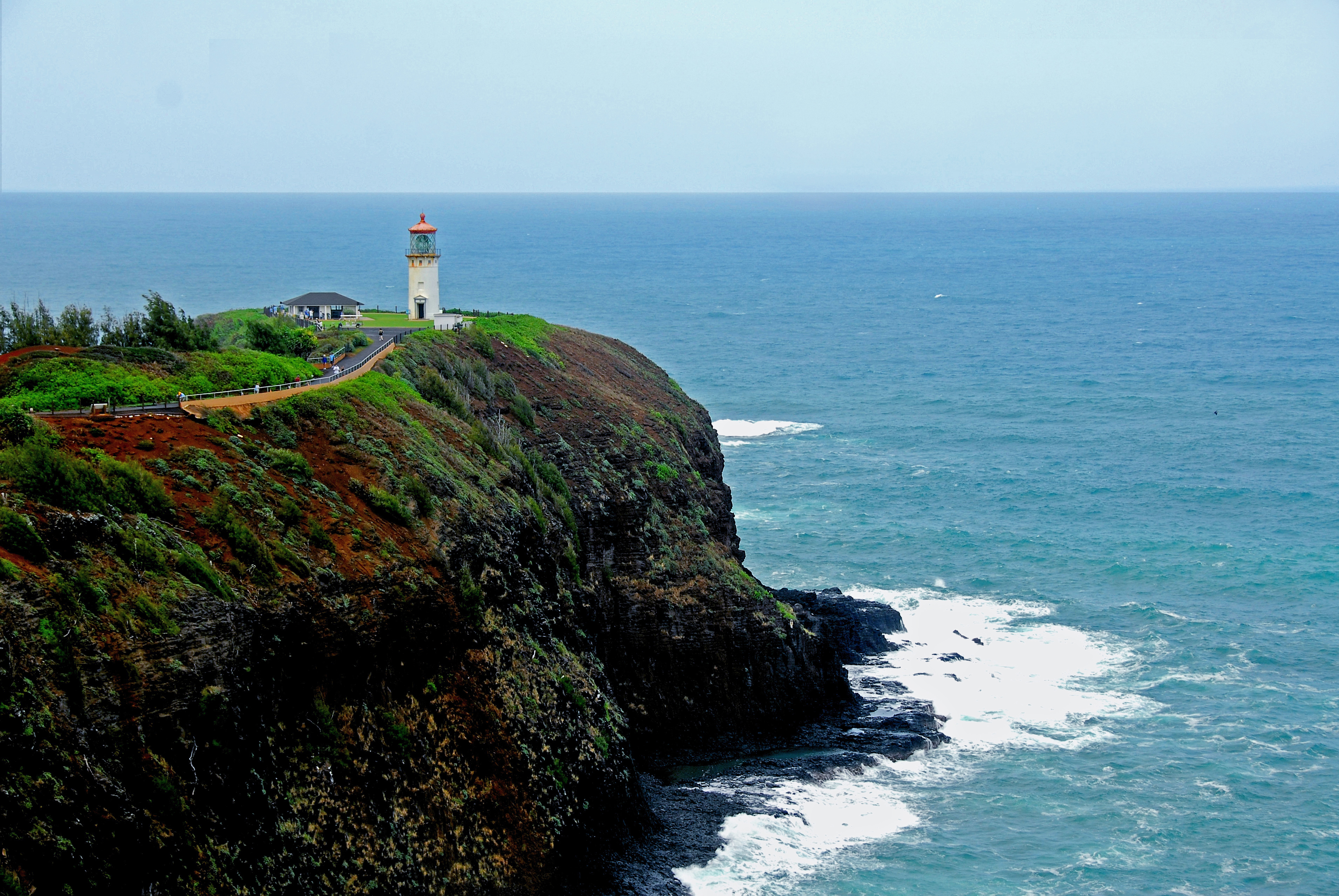
Kilauea Lighthouse (circa 2006)
The Daniel K. Inouye Kīlauea Point Lighthouse, also known as Kīlauea Light, is a lighthouse located on Kīlauea Point on the island of Kauai, Hawaii in the Kīlauea Point National Wildlife Refuge. History Kīlauea Point, a narrow, lava peninsula protruding from the northern shore of Kauai, was purchased from the Kīlauea Sugar Plantation Company in 1909 for one United States dollar. Before construction could begin, a method for delivering supplies to the point had to be developed. Due to the lack of good roads from the Nawiliwili harbor, the decision was made to bring the materials in by sea. The lighthouse tender ''Kukui'' would anchor offshore and then dispatch small boats with supplies to a cove near the point. Since there was no beach landing, the boats would anchor to cleats cemented into the lava rocks at the point. A boom derrick, constructed on a ledge above the water, would lift the supplies from the boats and place them on a loading platform above the water. Finally ... [...More Info...] [...Related Items...] OR: [Wikipedia] [Google] [Baidu] |
Nawiliwili Beach Park
Nawiliwili Beach Park is a beach park and port on the south-east coast of the island of Kauai in the Hawaiian Islands. It is located on Nāwiliwili Bay at , about south of Līhue. It is at the south end of Hawaii Route 51, known as Rice Street. Just to the west is Niumalu Beach Park. Across Nāwiliwili Bay is Kawai Point Kawai Point is a jutting headland on the south-east coast of the island of Kauai in the Hawaiian Islands. External links * Headlands of Kauai {{Hawaii-geo-stub .... References Beaches of Kauai Protected areas of Kauai Parks in Hawaii {{Hawaii-geo-stub ... [...More Info...] [...Related Items...] OR: [Wikipedia] [Google] [Baidu] |
VRB-25
The VRB-25 is a lighthouse optical system designed and built by Vega Industries Ltd. in Porirua, New Zealand. It was originally designed in 1993-95 with the assistance of the United States Coast Guard to meet USCG requirements for a robust mechanism requiring minimum maintenance. It has become the Coast Guard's standard 12 volt rotating beacon. The company's literature says there are more than 400 installations worldwide. More than a quarter of the active lighthouses in Maine have one installed. Components A microprocessor controlled 12 volt DC motor drives an array of six or eight acrylic Fresnel lenses around a bulb at one of 248 speeds ranging from 0.5 to 15.9 revolutions per minute (RPM). In the simplest case, all six lenses are used, so that for Boon Island Light, which shows one flash every five seconds, the mechanism rotates at two RPM. Eight lenses are used only when required to achieve more complex characteristics. Maximum range is achieved by using the slowest ... [...More Info...] [...Related Items...] OR: [Wikipedia] [Google] [Baidu] |
Molokai
Molokai , or Molokai (), is the fifth most populated of the eight major islands that make up the Hawaiian Islands, Hawaiian Islands archipelago in the middle of the Pacific Ocean. It is 38 by 10 miles (61 by 16 km) at its greatest length and width with a usable land area of , making it the fifth-largest in size of the main Hawaiian Islands and the List of islands of the United States by area, 27th largest island in the United States. It lies southeast of Oahu, Oahu across the wide Hawaiian islands channels, Kaʻiwi Channel and north of Lanai, Lānai, separated from it by the Hawaiian islands channels, Kalohi Channel. The island's agrarian economy has been driven primarily by cattle ranching, pineapple production, sugarcane production and small-scale farming. Tourism comprises a small fraction of the island's economy, and much of the infrastructure related to tourism was closed and barricaded in the early 2000s when the primary landowner, Molokai Ranch, ceased operations due ... [...More Info...] [...Related Items...] OR: [Wikipedia] [Google] [Baidu] |
Molokai Light
Molokai , or Molokai (), is the fifth most populated of the eight major islands that make up the Hawaiian Islands archipelago in the middle of the Pacific Ocean. It is 38 by 10 miles (61 by 16 km) at its greatest length and width with a usable land area of , making it the fifth-largest in size of the main Hawaiian Islands and the 27th largest island in the United States. It lies southeast of Oahu across the wide Kaʻiwi Channel and north of Lānai, separated from it by the Kalohi Channel. The island's agrarian economy has been driven primarily by cattle ranching, pineapple production, sugarcane production and small-scale farming. Tourism comprises a small fraction of the island's economy, and much of the infrastructure related to tourism was closed and barricaded in the early 2000s when the primary landowner, Molokai Ranch, ceased operations due to substantial revenue losses. In Kalawao County, on the Kalaupapa Peninsula on the north coast, settlements were established ... [...More Info...] [...Related Items...] OR: [Wikipedia] [Google] [Baidu] |
Moloka'i Light
Molokai , or Molokai (), is the fifth most populated of the eight major islands that make up the Hawaiian Islands archipelago in the middle of the Pacific Ocean. It is 38 by 10 miles (61 by 16 km) at its greatest length and width with a usable land area of , making it the fifth-largest in size of the main Hawaiian Islands and the 27th largest island in the United States. It lies southeast of Oahu across the wide Kaʻiwi Channel and north of Lānai, separated from it by the Kalohi Channel. The island's agrarian economy has been driven primarily by cattle ranching, pineapple production, sugarcane production and small-scale farming. Tourism comprises a small fraction of the island's economy, and much of the infrastructure related to tourism was closed and barricaded in the early 2000s when the primary landowner, Molokai Ranch, ceased operations due to substantial revenue losses. In Kalawao County, on the Kalaupapa Peninsula on the north coast, settlements were established ... [...More Info...] [...Related Items...] OR: [Wikipedia] [Google] [Baidu] |
Hyperradiant Fresnel Lens
Hyper-radial or hyperradiant Fresnel lenses are Fresnel lenses used in lighthouses. They are larger than "first-order" lenses, having a focal length (radius) of 1330 mm (52.36 inches). The idea was mentioned by Thomas Stevenson in 1869 and first proposed by John Richardson Wigham in 1872, and again proposed by Thomas Stevenson in 1885 (infringing Wigham's patent). The hyper-radial lens was made in 1885 by the F. Barbier Company in Paris as a test lens for the lighthouse illumination trials then going on at the South Foreland Lighthouse in the United Kingdom (UK). Chance Brothers Glass Company made their first hyper-radial lens in 1887 in the UK. These lenses were originally named biform, and later triform and quadriform lenses, by Wigham. Thomas Stevenson used the term hyperradiant lens, and later they were renamed the hyper-radial lens by James Kenward of the Chance Brothers Glass Company. The hyper-radial Fresnel lenses were the largest ever put into use and were installe ... [...More Info...] [...Related Items...] OR: [Wikipedia] [Google] [Baidu] |
Makapuʻu Point
Makapuʻu Point (also Makapuu Point) is the easternmost point on the Hawaiian island of Oʻahu, located in the Makapuʻu region. Twelve miles east of Honolulu, it is a popular hiking spot, offering great views of Makapuʻu and Waimanalo, Waimanalo Bay on one side and the Ka ʻIwi Channel on the other side. It is the home of the Makapuu Point Light, Makapuʻu Point Light, which was established in 1909; the light was automated in 1974. Containing one of the world's largest Fresnel lenses. According to Neal McHenry the procedure to produce another high Hyper-Radiant Fresnel Lens is no longer known. The Light House is lit by a single 1000 watt 120 volt alternating current lamp. Should the first lamp burn out a tangent lamp will automatically rotate into place. The light house and the area around it is owned by the U.S. Coast Guard. The location is also popular for viewing the ocean, whale watching in the Winter, or seeing the neighboring islands of Molokai and Lanai. Additionally, one ... [...More Info...] [...Related Items...] OR: [Wikipedia] [Google] [Baidu] |
Lahaina, Hawaii
Lahaina ( haw, Lāhainā) is the largest census-designated place (CDP) in West Maui, Maui County, Hawaii, United States and includes the Kaanapali and Kapalua beach resorts. As of the 2020 census, the CDP had a resident population of 12,702. Lahaina encompasses the coast along Hawaii Route 30 from a tunnel at the south end, through Olowalu and to the CDP of Napili-Honokowai to the north. During the tourist season, the population can swell to nearly 40,000 people. Lahaina's popularity as a tropical getaway has made its real estate some of the most expensive in Hawaii; many houses and condominiums sell for more than $5 million. History In days of native rule Lahaina was the royal capital of Maui Loa, ("high chief") of the island of Maui, after he ceded the royal seat of Hana to the ruler of Hawaii Island. In Lahaina, the focus of activity is along Front Street, which dates back to the 1820s. It is lined with stores and restaurants and often packed with tourists. The Banyan ... [...More Info...] [...Related Items...] OR: [Wikipedia] [Google] [Baidu] |


