|
List Of Rivers In Andhra Pradesh
The major rivers of Andhra Pradesh are Godavari and Krishna. The coastline of Andhra Pradesh has a length of 975 km (606 mi), the second-longest coastline in India after Gujarat. List * Krishna River * Godavari River * Penna River * Tungabhadra River * Vamsadhara River * Vedavathi River * Swarnamukhi River * Veda River * Avathi River * Jayamangali River * Chitravathi River * Sagileru River * Cheyyeru River * Kundu River * Maldevi River * Papagni River * Kunderu River * Bahuda River * Puncha River * Mahendratanaya River * Nagavali River * Sileru River * Arani River * Bendi Gedda * Bahuda River * Budameru River * Champavathi River * Garibula Gedda * Galeru River * Gosthani River * Gundlakamma River * Kinnerasani River * Kandaleru River * Kandivalasa River * Kalangi River * Koringa River * Kundu River * Madala River * Manneru River * Munneru River * Murredu River * Nadari River * Kosasthalaiyar River * Narava Gedda * Palar River * Paleru River * Pedd ... [...More Info...] [...Related Items...] OR: [Wikipedia] [Google] [Baidu] |
Andhra Pradesh
Andhra Pradesh (, abbr. AP) is a state in the south-eastern coastal region of India. It is the seventh-largest state by area covering an area of and tenth-most populous state with 49,386,799 inhabitants. It is bordered by Telangana to the north-west, Chhattisgarh to the north, Odisha to the north-east, Tamil Nadu to the south, Karnataka to the west and the Bay of Bengal to the east. It has the second longest coastline in India after Gujarat, of about . Andhra State was the first state to be formed on a linguistic basis in India on 1 October 1953. On 1 November 1956, Andhra State was merged with the Telugu-speaking areas (ten districts) of the Hyderabad State to form United Andhra Pradesh. ln 2014 these merged areas of Hyderabad State are bifurcated from United Andhra Pradesh to form new state Telangana . Present form of Andhra similar to Andhra state.but some mandalas like Bhadrachalam still with Telangana. Visakhapatnam, Guntur, Kurnool is People Capital of And ... [...More Info...] [...Related Items...] OR: [Wikipedia] [Google] [Baidu] |
Nagavali River
The River Nagavali also known as Langulya is one of the main rivers of Southern Odisha and North Andhra States in India, between Rushikulya and Godavari basins. Origin and course Nagavali River originates from a hill near Lakhbahal village in Thuamul Rampur block of Kalahandi District. It touches Nakrundi, Kerpai areas of Kalahandi, Kalyansinghpur and Rayagada of Rayagada district of Odisha and merged in Bay of Bengal near Kallepalli village near Srikakulam after crossing by the side of Srikakulam of Andhra Pradesh. It is an independent river with its own basin. The total length of the river is about , of which are in Odisha and the rest in Andhra Pradesh. The catchment area of the basin is . Nagavali is an interstate river with and river basin area located in Odisha and Andhra Pradesh respectively. The river basin receives average rainfall annually. The yearly water availability in the river basin at Narayanapuram barrage is 1.117 billion cubic meters on average. The u ... [...More Info...] [...Related Items...] OR: [Wikipedia] [Google] [Baidu] |
Kosasthalaiyar River
Kosasthalaiyar River, also known as Kortalaiyar, is one of the three rivers that flow in the Chennai metropolitan area. The river and its course Kosasthalaiyar is long and originates near Pallipattu in Thiruvallur district and drains into the Bay of Bengal. Its northern tributary Nagari river originates in Chitoor district of Andhra Pradesh and joins the main river in the backwaters of Poondi reservoir. Its catchment area is spread over Vellore, Chitoor, North Arcot, Thiruvallur and Chennai districts. It has a catchment area in North Arcot District where it branches near Kesavaram Anicut and this tributary flows to the Chennai city as Cooum River, while the main river flows to the Poondi reservoir. From Poondi reservoir, the river flows through Thiruvallur District, enters the Chennai metropolitan area, and joins the sea at Ennore Creek. The river has 9 check dams. There are two check dams across the river at Tamaraipakkam and Vallur. The excess discharge in the river is con ... [...More Info...] [...Related Items...] OR: [Wikipedia] [Google] [Baidu] |
Munneru River
Munneru is a left tributary of the Krishna River. It originates in Warangal District of Telangana, India and flows in the districts of Khammam District and Krishna District. The river is named after Rishi Maudgalya, who is said to have created this river with his spiritual power and performed a penance ritual in Khammam. Origins It originates near Mahabubabad town of Warangal District, Telangana. Flow It flows through Dornakal Eru and comes via Kamanchkal to Danavaigudam suburb of Khammam city where it has a small Dam in order to facilitate water collection. Munneru acts as a water source to Khammam city. It goes through ManchiKanti Nagar, Kalavoddu, Moti Nagar, Prakash Nagar and Dhamsalampuram suburbs of Khammam city. It reaches Chinna Mandava and Lingala villages of Krishna District. It flows into Penuganchiprolu town, Keesara village and finally discharges into the Krishna river at Eturu village near Nandigama downstream of Pulichintala dam. Muniyeru barrage was construc ... [...More Info...] [...Related Items...] OR: [Wikipedia] [Google] [Baidu] |
Koringa River
Koringa (also known as Coringa, te, కోరింగ నది) is a branch of the Godavari River flowing in the East Godavari District of Andhra Pradesh, India. History The river was also historically known as the ''Coringa'', ''Koringa'', ''Corangi'', ''Coringuy''. Geography The ''Goutami Godavari'' is the Eastern branch of the Godavari river, that splits at Vijjeswaram, while the ''Vasista Godavari'' is the Western branch. Other main branch is Vainateya, which splits at Dowleswaram Dowleswaram is a part of Greater Rajamahendravaram Municipal Corporation (GRMC). It also forms a part of Godavari Urban Development Authority. Landmarks Sir Arthur Cotton built the Dowleswaram Barrage across the Godavari The Godavari .... Tulya, Atreya and Bharadwaja are minor tributaries. See also * Yanam, Pondicherry * Godavari River {{coord missing, Andhra Pradesh Rivers of Andhra Pradesh Geography of East Godavari district Rivers of India ... [...More Info...] [...Related Items...] OR: [Wikipedia] [Google] [Baidu] |
Kinnerasani River
Kinnerasani is an important tributary of Godavari flowing through the Warangal and Bhadradri districts of Telangana and Eluru district of Andhra Pradesh. In the Khammam District, a dam known as the Kinnerasani Dam is built on this river. The back waters of the dam are surrounded by verdant hills and come to be protected under the precincts of the Kinnerasani Wildlife Sanctuary. The river drains on the right bank of Godavari The Godavari (IAST: ''Godāvarī'' �od̪aːʋəɾiː is India's second longest river after the Ganga river and drains into the third largest basin in India, covering about 10% of India's total geographical area. Its source is in Trimbakeshwa ... in Telangana and forms common boundary between Andhra Pradesh and Telangana states before its confluence with main Godavari river. References {{Hydrography of Andhra Pradesh Tributaries of the Godavari River Rivers of Telangana Rivers of Andhra Pradesh Geography of West Godavari district Rivers of ... [...More Info...] [...Related Items...] OR: [Wikipedia] [Google] [Baidu] |
Gundlakamma River
The Gundlakamma River ( te, గుండ్లకమ్మ నది) is a seasonal waterway that flows through the east-central part of the state of Andhra Pradesh, India. It arises in the Nallamala Hills, an offshoot of the Eastern Ghats. Its main headwaters lie some 6 kilometers from the village of Ardhaveedu, Prakasam district at an altitude of 425 m. above MSL. Numerous mountain streams join it as it descends down the thickly forested hills through a series of curves and tight bends. It follows a north-easterly direction and enters the plains near Cumbum, after flowing through a town named after it. Gundlakamma is the largest of all the rivers that originate from the Nallamalla Hills. A 15th-century dam built by the Gajapati kings straddles the river on its entry into the plains. It is an earthen dam that plugs the river flows through. Called the Cumbum Dam, it is high, has a drainage area of and a capacity of . The river then flows past the town of Markapur and towards t ... [...More Info...] [...Related Items...] OR: [Wikipedia] [Google] [Baidu] |
Gosthani River
The Gosthani rises in the Ananthagiri Hills of the Eastern Ghats and flows through the Borra Caves which lie near its source. It is the largest river flowing through Visakhapatnam city. It flows for 120 km before joining the Bay of Bengal through an estuary near Bheemunipatnam. The river basin drains the two coastal districts of Vizianagaram and Visakhapatnam. The basin exhibits a subdendritic and dendritic pattern of drainage. The Gosthani's is a minor river basin with a total drainage area of less than 2000 km2. Much of the basin is covered by khondalite group of gneissic rocks. About 3% of the total area of the Visakhapatnam district is under the Gosthani basin. The river is rainfed, receiving an average rainfall of 110 cm most of which comes from the south-west monsoon. There are several red sand hills near Bheemunipatnam, where the Gosthani joins the Bay of Bengal, which are reminiscent of the Chambal ravines. These are thought to have been formed si ... [...More Info...] [...Related Items...] OR: [Wikipedia] [Google] [Baidu] |
Galeru
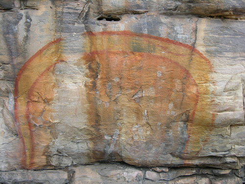
The Rainbow Serpent or Rainbow Snake is a common deity often seen as the creator God, known by numerous names in different Australian Aboriginal languages by the many different Aboriginal peoples. It is a common motif in the art and religion of many Aboriginal Australian peoples. Much like the archetypal mother goddess, the Rainbow Serpent creates land and diversity for the Aboriginal people, but when disturbed can bring great chaos. There are many names and stories associated with the serpent, all of which communicate the significance and power of this being within Aboriginal mythology, which includes the worldview commonly referred to as The Dreaming. The serpent is viewed as a giver of life through its association with water, but can be a destructive force if angry. The Rainbow Serpent is one of the most common and well-known Aboriginal stories and is of great importance to Aboriginal society. Not all of the myths in this family describe the ancestral being as a snake. O ... [...More Info...] [...Related Items...] OR: [Wikipedia] [Google] [Baidu] |
Champavathi River
River Champavathi ( te, చంపావతి) is a small river which originates in the Eastern Ghats at an altitude of 1,200 metres above mean sea level near Andra village and flows eastwards and joins the Bay of Bengal near the village Konada. The river passes through Gajapathinagaram Gajapathinagaram is a census town in Vizianagaram district of the Indian state of Andhra Pradesh. It is located in Gajapathinagaram mandal of Vizianagaram revenue division. It is located on National Highway 43 (India), National Highway 26 betwee ..., Nellimarla, Saripalli, Denkada, Palem and Natavalasa of Vizianagaram district. The river has four main tributaries Eduvampula Gedda, Chitta Gedda, Pothula Gedda and Gadi Gedda. The basin has a drainage area of 1,410 square kilometres. This area is divisible into Hilly terrain (Madugula hills), Vizianagaram plains and Coastal plains. Denkada anicut was constructed across Champavathi River in 1965–1968. The project is located near ... [...More Info...] [...Related Items...] OR: [Wikipedia] [Google] [Baidu] |
Budameru Rivulet
Budameru is a rivulet in Krishna district which originates in the hills surrounding Mylavaram and empties itself into Kolleru Lake. Budameru is also known as ''The Sorrow of Vijayawada''. In order to control the floods, the river was dammed at Velagaleru village and a diversion channel named, ''Budameru Diversion Channel (BDC)'' was constructed from Velagaleru to join Krishna River upstream of Prakasam Barrage. This is the first water diversion to the main Krishna river from another river basin. The diversion channel has 10,500 cusecs flow capacity. This diversion channel is made part of Polavaram right bank canal at its tail end. However its flow capacity is to be enhanced to 17,500 cusecs to match with the design capacity of Polavaram right bank canal. Some water from Polavaram right bank canal can be fed to Eluru canal of Krishna delta by allowing the water to flow in the Budemeru river and connecting the river by gravity to the canal as river is passing by the side of this ... [...More Info...] [...Related Items...] OR: [Wikipedia] [Google] [Baidu] |


