|
List Of Regional Snowfall Index Category 5 Winter Storms
The Regional Snowfall Index (RSI) is a system used by NOAA to assess the societal impact of winter storms in the United States. The system is a replacement for the Northeast Snowfall Impact Scale (NESIS) system which, unlike the former; assesses winter storm impacts outside of the Northeastern United States. Since its initiation the NCDC has retroactively assigned RSI values to over 500 historical storms since 1900. Storms are ranked from Category 0 to 5 on the scale; with the former being classified as "Nuisance" and the latter as "Extreme". The impact of the storms is assessed in six different regions of the United States: the Northeast, Northern Rockies and Plains, Ohio Valley, South, Southeast and the Upper Midwest. A Category 5 ''Extreme'' ranking is indicated by a numerical score of 18 or higher on the scale. Out of the over 500 historical storms assessed since 1900, only twenty-six storms have been given a Category 5 ranking. The highest ranking storm on the list is the ... [...More Info...] [...Related Items...] OR: [Wikipedia] [Google] [Baidu] |
1991 Halloween Blizzard
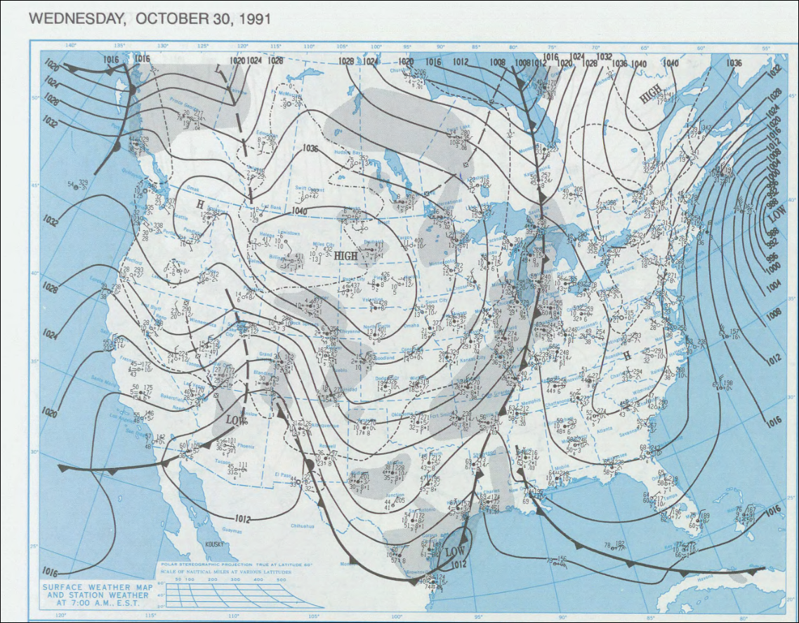
The 1991 Halloween blizzard was a powerful storm that caused a period of heavy snowfall and ice accumulation, which affected parts of the Upper Midwest of the United States, from October 31 to November 3, 1991. Over the last week of October 1991, a large storm system over the Atlantic Ocean (1991 Perfect Storm) blocked most of the weather patterns over the eastern half of the United States, and in turn, moisture from the Gulf of Mexico was funneled straight northward over the affected region. By the time the precipitation stopped falling, many cities in the eastern half of Minnesota and northwestern Wisconsin had witnessed record early-season snowfall accumulations, while parts of southern Minnesota and northern Iowa were crippled by a large ice storm. Arctic air that was pulled southward behind the storm had combined with the heavy snow pack to produce many record low temperatures. Between the blizzard and the ice storm, 22 people were killed and over 100 were injured. Meteorol ... [...More Info...] [...Related Items...] OR: [Wikipedia] [Google] [Baidu] |
Climate Of The United States
The climate of the United States varies due to changes in latitude, and a range of geographic features, including mountains and deserts. Generally, on the mainland, the climate of the U.S. becomes warmer the further south one travels, and drier the further west, until one reaches the West Coast. West of 100°W, much of the U.S. has a cold semi-arid climate in the interior upper western states (Idaho to the Dakotas), to warm to hot desert and semi-arid climates in the southwestern U.S. East of 100°W, the climate is humid continental in northern areas (locations roughly above 40°N, Northern Plains, Midwest, Great Lakes, New England), transitioning into a humid temperate climate from the Southern Plains and lower Midwest east to the Middle Atlantic states (Virginia to southern Connecticut). A humid subtropical climate is found along and south of a mostly east–west line from the Virginia/Maryland capes (north of the greater Norfolk, Virginia area), westward to approximately ... [...More Info...] [...Related Items...] OR: [Wikipedia] [Google] [Baidu] |
List Of Blizzards
This is a list of blizzards, arranged alphabetically by continent. A blizzard is defined as a severe snowstorm characterized by strong sustained winds of at least and lasting for three hours or more. The list states blizzards in various countries since 1972. Africa Asia Australia Europe North America South America See also * List of ice storms * List of costly or deadly hailstorms * List of dust storms with visibility of 1/4 mile or less, or meters or less * List of weather records * Lowest temperature recorded on Earth References {{DEFAULTSORT:Blizzards Weather hazards Severe weather and convection ... [...More Info...] [...Related Items...] OR: [Wikipedia] [Google] [Baidu] |
List Of Northeast Snowfall Impact Scale Winter Storms
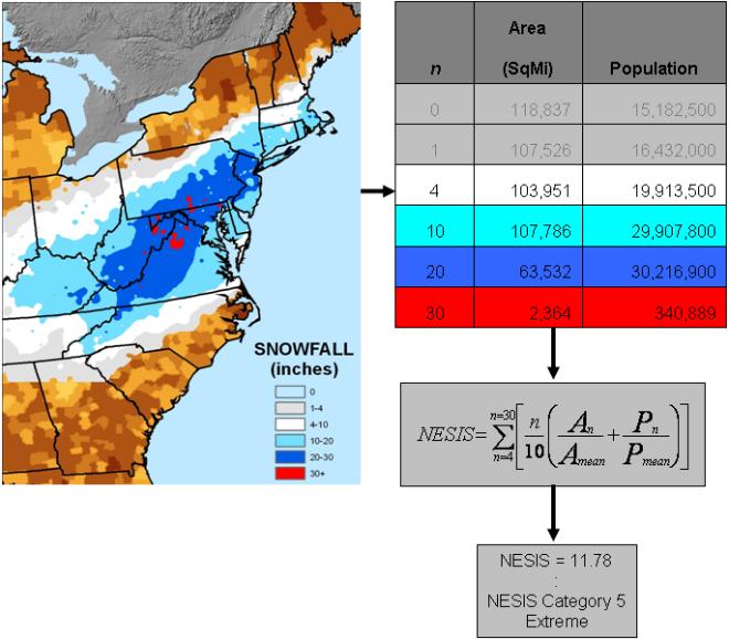
The Northeast Snowfall Impact Scale (NESIS) is a scale used to categorize winter storms in the Northeast United States. The scale was developed by meteorologists Paul Kocin and Louis Uccellini, and ranks snowstorms from Category 1 ("notable") to Category 5 ("extreme"). Only two historical blizzards, the 1993 Storm of the Century and the North American blizzard of 1996 are rated in the 5 "extreme" category. The scale differs from the Saffir–Simpson Hurricane Scale and Fujita Scale, which are used to classify tropical cyclones and tornadoes, respectively, in that it takes into account the number of people affected by the storm. The scale, as devised, is intended chiefly to assess past storms rather than assist in forecasts.Kocin and Uccellini, pp. 269–270 List There are two available values for NESIS. The original values that Paul Kocin and Louis Uccellini computed for storms in their original 2004 work "A Snowfall Impact Scale Derived From Northeast Storm Snowfall Distr ... [...More Info...] [...Related Items...] OR: [Wikipedia] [Google] [Baidu] |
List Of Regional Snowfall Index Category 4 Winter Storms
The Regional Snowfall Index (RSI) is a system used by NOAA to assess the societal impacts of winter storms in the United States. The scale is a replacement for the Northeast Snowfall Impact Scale (NESIS) system, which was used for winter storms just in the Northeastern United States; Regional Snowfall Index assesses winter storm impacts in the six easternmost regions of the United States instead of just the Northeast. Since its initiation, the NCDC has assigned RSI values to nearly 600 winter storms since 1900. Storms are ranked from Category 0 "Nuisance" to Category 5 "Extreme" on the scale. A Category 4 winter storm on the RSI scale is classified as "Crippling". The impact of the storms is assessed in six different regions of the United States: the Northeast, Northern Rockies and Plains, Ohio Valley, South, Southeast, and Upper Midwest. A Category 4 "Crippling" ranking is indicated by a numerical score between 10 and 18 on the scale. Out of the nearly 600 historical winter stor ... [...More Info...] [...Related Items...] OR: [Wikipedia] [Google] [Baidu] |
January 2016 United States Blizzard
The January 2016 United States blizzard was a blizzard that produced up to 3 ft (91 cm) of snow in parts of the Mid-Atlantic and Northeastern United States from January 22–24, 2016. Evolving from a shortwave trough that formed in the Pacific Northwest on January 19, the system consolidated into a defined low-pressure area on January 21 over Texas. Regarding it as a "potentially historic blizzard", meteorologists indicated the storm could produce more than of snow across a wide swath of the Mid-Atlantic region and could "paralyze the eastern third of the nation". Winter weather expert Paul Kocin described the blizzard as "kind of a top-10 snowstorm". On January 20–22, the governors of eleven states and the mayor of Washington, D.C. declared a state of emergency in anticipation of significant snowfall and blizzard conditions. Approximately 103 million people were affected by the storm, with 33 million people placed under blizzard warnings. More than 13,00 ... [...More Info...] [...Related Items...] OR: [Wikipedia] [Google] [Baidu] |
January 31 – February 2, 2011 North American Blizzard
The 2011 Groundhog Day blizzard was a powerful and historic winter storm that affected large swaths of the United States and Canada from January 31 to February 2, 2011, especially on Groundhog Day. During the initial stages of the storm, some meteorologists predicted that the system would affect over 100 million people in the United States. The storm brought cold air, heavy snowfall, blowing snow, and mixed precipitation on a path from New Mexico and northern Texas to New England and Eastern Canada. The Chicago area saw of snow and blizzard conditions, with winds of over . With such continuous winds, the blizzard continued to the north and affected Eastern and Atlantic Canada. Blizzard conditions affected many other large cities along the storm's path, including Tulsa, Oklahoma City, Kansas City, St. Louis, Springfield, El Paso, Las Cruces, Des Moines, Milwaukee, Detroit, Chicago, Indianapolis, Dayton, Cleveland, New York City, New York's Capital District, and Boston. Many ... [...More Info...] [...Related Items...] OR: [Wikipedia] [Google] [Baidu] |
2009 North American Christmas Blizzard
The 2009 North American Christmas blizzard was a powerful winter storm and severe weather event that affected the Midwestern United States, Great Plains, Southeastern United States, the Eastern Seaboard, and parts of Ontario. The storm began to develop on December 22 before intensifying to produce extreme winds and precipitation by the morning of December 24. The storm's rapid development made it difficult for forecasters to predict. The blizzard was reported to have claimed at least 21 lives, and disrupted air travel during the Christmas travel season. In the Southeastern and Central United States, an outbreak of 28 tornadoes occurred between December 23–24. The storm, a Category 5 "Extreme" one on the Regional Snowfall Index scale, was the first winter weather event to rank as such since the North American blizzard of 1996. Impact Snowfall Snowfall varied across the United States. South Dakota likely received the most, with . In Minnesota, was received near Pequaywan Lake ... [...More Info...] [...Related Items...] OR: [Wikipedia] [Google] [Baidu] |
North American Blizzard Of 1996
The North American blizzard of 1996 was a severe nor'easter that paralyzed the United States East Coast with up to of wind-driven snow from January 6 to January 8, 1996. This storm was a classic example of a nor'easter, but the storm would not have been as historically significant without the presence of the arctic high pressure system located to the north of New York. It was followed by another storm, an Alberta Clipper, on January 12, then unusually warm weather and torrential rain which caused rapid melting and river flooding in the Northeast Floods later that month. Along with the March Superstorm of 1993 and the January 2016 United States blizzard, it is one of only three snowstorms to receive the top rating of 5, or "Extreme", on the Northeast Snowfall Impact Scale (NESIS). Impact Virginia Most of Virginia was impacted with the more central and western parts receiving of snow. Roanoke got a record-breaking . The heaviest snow fell in Page County, with around . Snowfa ... [...More Info...] [...Related Items...] OR: [Wikipedia] [Google] [Baidu] |
1993 Storm Of The Century
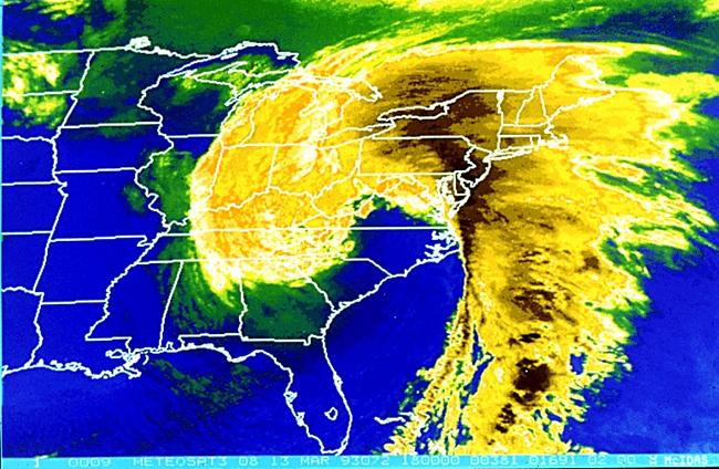
The 1993 Storm of the Century (also known as the 93 Superstorm, The No Name Storm, or the Great Blizzard of '93/1993) was a cyclonic storm that formed over the Gulf of Mexico on March 12, 1993. The cold weather, heavy snowfall, high winds and storm surges that the storm brought affected a very large area; at its height, it stretched from Canada to Honduras. The cyclone moved through the Gulf of Mexico and then through the eastern United States before moving on to eastern Canada. It eventually dissipated in the North Atlantic Ocean on March 15. Heavy snow was first reported in highland areas as far south as Alabama and northern Georgia, with Union County, Georgia reporting up to of snow. Birmingham, Alabama, reported a rare of snow. The Florida Panhandle reported up to of snow, with hurricane-force wind gusts and record low barometric pressures. Between Louisiana and Cuba, the hurricane-force winds produced high storm surges across the big bend of Florida which, in combinati ... [...More Info...] [...Related Items...] OR: [Wikipedia] [Google] [Baidu] |
Northeastern United States Blizzard Of 1978
The Northeastern United States blizzard of 1978 was a catastrophic, historic nor'easter that struck New England, New Jersey, Pennsylvania and the New York metropolitan area. The Blizzard of '78 formed on Sunday, February 5, 1978, and broke up on February 7. The storm was primarily known as "Storm Larry" in Connecticut, following the local convention promoted by the Travelers Weather Service on television and radio stations there. Snow fell mostly from Monday morning, February 6, to the evening of Tuesday, February 7. Connecticut, Rhode Island, and Massachusetts were hit especially hard by this storm. Boston received a record-breaking of snow; Providence also broke a record, with of snow; Atlantic City broke an all-time storm accumulation, with , two Philadelphia suburban towns in Chester County received while the City of Philadelphia received . Nearly all economic activity was disrupted in the worst-hit areas. The storm killed about 100 people in the Northeast and injured ... [...More Info...] [...Related Items...] OR: [Wikipedia] [Google] [Baidu] |


