|
Lincoln Highway In Greene County, Iowa
The Lincoln Highway in Greene County, Iowa is a multiple property submission to the National Register of Historic Places, which was approved on March 29, 1993. It includes five individual listings and five historic districts located in Greene County, Iowa, United States. They encompass abandoned sections of dirt roads, paved sections that are now part of other highways, and various sites, objects, structures and pieces of infrastructure that were a part of the Lincoln Highway. The years of historical significance are 1912 to 1928. The Lincoln Highway in Iowa Carl Fisher was an American automotive and real estate entrepreneur who conceived the Lincoln Highway in 1912, and helped to develop it. Connecting New York City to San Francisco, it was the first highway to cross the United States. The intention to develop the highway was announced in 1913, and Iowans raised over $5 million for the construction of the road. There were no particularly good options to cross Iowa, but the ... [...More Info...] [...Related Items...] OR: [Wikipedia] [Google] [Baidu] |
Greene County, Iowa
Greene County is a county located in the U.S. state of Iowa. As of the 2020 census, the population was 8,771. The county seat is Jefferson. The county is named in honor of General Nathanael Greene. History Greene County was formed on January 15, 1851, and from 1854, self-governed. It was named after General Nathanael Greene, a hero in the Revolutionary War. The first settler was Truman Davis. He settled on the Raccoon River. The first courthouse was built in 1856 from wood. Previously court was held in a log cabin southeast of Jefferson. The second courthouse, of red brick, was built in 1870. The present Greene County Courthouse used today was built in 1917. Geography According to the U.S. Census Bureau, the county has a total area of , of which is land and (0.3%) is water. Major highways * U.S. Highway 30 * Iowa Highway 4 * Iowa Highway 25 * Iowa Highway 144 Adjacent counties *Calhoun County (northwest) * Webster County (northeast) * Boone County (east) *Dalla ... [...More Info...] [...Related Items...] OR: [Wikipedia] [Google] [Baidu] |
Marion, Iowa
Marion is a city in Linn County, Iowa, United States. The population was 26,294 at the 2000 census and was 41,535 in 2020, an increase of 58%. The city is located next to Cedar Rapids and part of the Cedar Rapids Metropolitan Statistical Area. History The town was named after Francis Marion, a hero of the Revolutionary War. The site was selected in 1839 to be the first county seat of the newly organized Linn County. After years of debate over moving the county seat to Cedar Rapids, it was put to a vote in 1919. The vote was 9,960 in favor of moving the seat and 4,823 not in favor. Each year, the city hosts the annual "Swamp Fox Festival", a celebration of Marion's heritage named in honor of the "Swamp Fox", Francis Marion's nickname during the Revolutionary War. The event typically includes a 5K run, parade, fireworks, and many other family friendly activities. The town was the home to St. Berchman's Seminary, established in 1905 by the Sisters of Mercy as a boarding sch ... [...More Info...] [...Related Items...] OR: [Wikipedia] [Google] [Baidu] |
Cincinnati, Ohio
Cincinnati ( ) is a city in the U.S. state of Ohio and the county seat of Hamilton County. Settled in 1788, the city is located at the northern side of the confluence of the Licking and Ohio rivers, the latter of which marks the state line with Kentucky. The city is the economic and cultural hub of the Cincinnati metropolitan area. With an estimated population of 2,256,884, it is Ohio's largest metropolitan area and the nation's 30th-largest, and with a city population of 309,317, Cincinnati is the third-largest city in Ohio and 64th in the United States. Throughout much of the 19th century, it was among the top 10 U.S. cities by population, surpassed only by New Orleans and the older, established settlements of the United States eastern seaboard, as well as being the sixth-most populous city from 1840 until 1860. As a rivertown crossroads at the junction of the North, South, East, and West, Cincinnati developed with fewer immigrants and less influence from Europe than Ea ... [...More Info...] [...Related Items...] OR: [Wikipedia] [Google] [Baidu] |
Grand Junction, Iowa
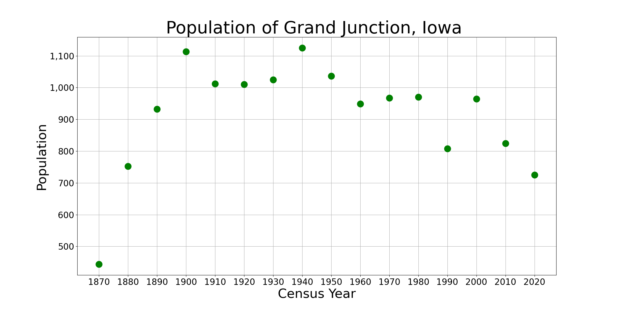
Grand Junction is a city in Greene County, Iowa, United States. The population was 725 at the time of the 2020 census. History Grand Junction took its name from its position at the junction of the Keokuk and Des Moines and the Chicago and Northwestern railroads. Grand Junction was incorporated in 1873. Geography Grand Junction is located at (42.031161, -94.235377). According to the United States Census Bureau, the city has a total area of , all land. Demographics 2010 census As of the census of 2010, there were 824 people, 329 households, and 199 families residing in the city. The population density was . There were 383 housing units at an average density of . The racial makeup of the city was 96.6% White, 0.6% African American, 1.2% Native American, 0.7% Asian, 0.5% from other races, and 0.4% from two or more races. Hispanic or Latino of any race were 1.8% of the population. There were 329 households, of which 30.1% had children under the age of 18 living with them, 43.8 ... [...More Info...] [...Related Items...] OR: [Wikipedia] [Google] [Baidu] |
Boone County, Iowa
Boone County is a county in the U.S. state of Iowa. As of the 2020 census, the population was 26,715. Its county seat is Boone. Boone County comprises the Boone, IA Micropolitan Statistical Area, which is included in the Des Moines-Ames-West Des Moines, IA Combined Statistical Area. History The land that now forms Boone and several other Iowa counties was ceded by the Sac and Fox nation to the United States in a treaty signed on October 11, 1842. On January 13, 1846, the legislative body of the Indiana Territory authorized creation of twelve counties in the Iowa Territory, with general descriptions of their boundaries. Boone County's name referred to Captain Nathan Boone, son of Daniel Boone, an American pioneer who formed the Wilderness Trail and founded the settlement of Boonesborough, Kentucky. County residents selected Boonesboro as the county seat in 1851. The first building erected in the new settlement was a double log house, to be used as interim county office an ... [...More Info...] [...Related Items...] OR: [Wikipedia] [Google] [Baidu] |
Baluster
A baluster is an upright support, often a vertical moulded shaft, square, or lathe-turned form found in stairways, parapets, and other architectural features. In furniture construction it is known as a spindle. Common materials used in its construction are wood, stone, and less frequently metal and ceramic. A group of balusters supporting a handrail, coping, or ornamental detail are known as a balustrade. The term baluster shaft is used to describe forms such as a candlestick, upright furniture support, and the stem of a brass chandelier. The term banister (also bannister) refers to a baluster or to the system of balusters and handrail of a stairway. It may be used to include its supporting structures, such as a supporting newel post. Etymology According to the ''Oxford English Dictionary'', "baluster" is derived through the french: balustre, from it, balaustro, from ''balaustra'', "pomegranate flower" rom a resemblance to the swelling form of the half-open flower (''illust ... [...More Info...] [...Related Items...] OR: [Wikipedia] [Google] [Baidu] |
Headwall
In physical geography and geology the headwall of a glacial cirque is its highest cliff. The term has been more broadly used to describe similar geomorphic features of non-glacial origin consisting of a concave depression with convergent slopes typically of 65 percent or greater forming the upper end of a drainage valley. In civil engineering, a headwall is a small retaining wall placed at the inlet or outlet of a stormwater pipe or culvert A culvert is a structure that channels water past an obstacle or to a subterranean waterway. Typically embedded so as to be surrounded by soil, a culvert may be made from a pipe, reinforced concrete or other material. In the United Kingdom .... In medicine, a headwall is the wall at the head end of a hospital bedspace. The bed abuts this headwall perpendicularly, which is furnished with equipment such as regulators for supplemental oxygen, regulators for suction, suction canisters, connections for the call bell system, lighting, elect ... [...More Info...] [...Related Items...] OR: [Wikipedia] [Google] [Baidu] |
Jefferson Square Commercial Historic District
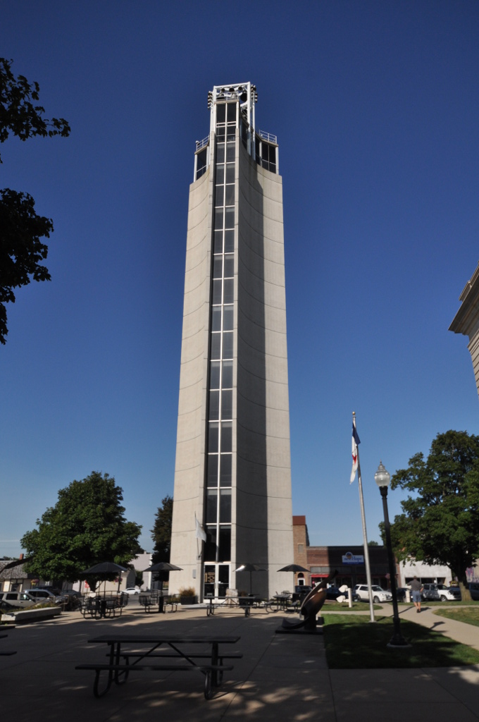
The Jefferson Square Commercial Historic District is a nationally recognized historic district located in Jefferson, Iowa, United States. It was listed on the National Register of Historic Places in 2011. At the time of its nomination the district consisted of 59 resources, including 38 contributing buildings, one contributing structure, one contributing object, 18 non-contributing buildings, and one non-contributing object. The district covers the original central business district. The commercial buildings are from one to three stories in height, and Late Victorian architectural styles dominate. The period of significance dates from 1873, with the construction of the oldest recognizable surviving building, to 1966, with the completion of the Mahanay Memorial Carillon Tower. The tower dominates not only the district, but Jefferson as well. Planning for the tower began before World War II. The Modern Movement, limestone sheathed, structure stands on the southwest corner of ... [...More Info...] [...Related Items...] OR: [Wikipedia] [Google] [Baidu] |
Contributing Property
In the law regulating historic districts in the United States, a contributing property or contributing resource is any building, object, or structure which adds to the historical integrity or architectural qualities that make the historic district significant. Government agencies, at the state, national, and local level in the United States, have differing definitions of what constitutes a contributing property but there are common characteristics. Local laws often regulate the changes that can be made to contributing structures within designated historic districts. The first local ordinances dealing with the alteration of buildings within historic districts was passed in Charleston, South Carolina in 1931. Properties within a historic district fall into one of two types of property: contributing and non-contributing. A contributing property, such as a 19th-century mansion, helps make a historic district historic, while a non-contributing property, such as a modern medical clinic ... [...More Info...] [...Related Items...] OR: [Wikipedia] [Google] [Baidu] |


