|
Lesser Cyclades
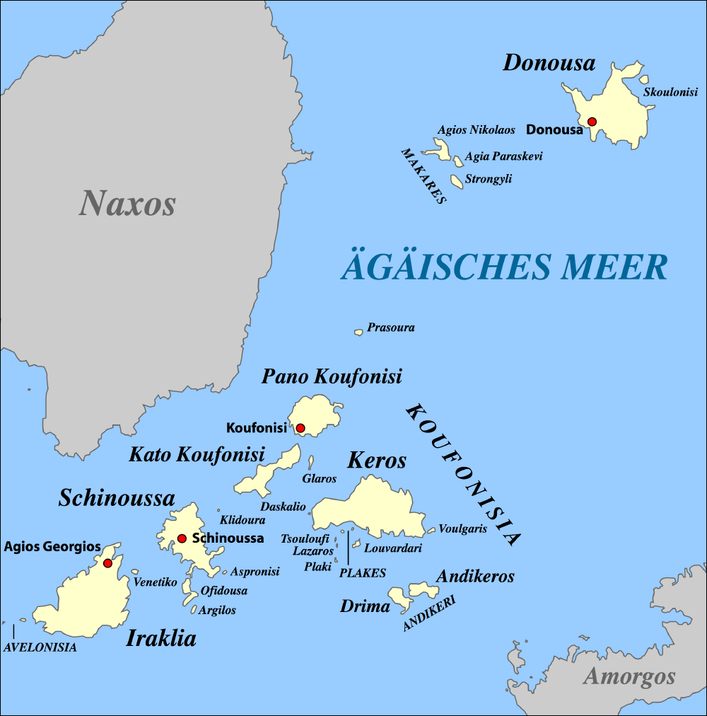
The Lesser Cyclades or Small Cyclades ( el, Μικρές Κυκλάδες) is an island complex in the Aegean Sea, inside the archipelago of the Cyclades. It is located to the south-east of Naxos and comprises 32 islands and rocks. The main islands are Ano Koufonisi, Kato Koufonisi, Irakleia, Schoinoussa, Donousa and Keros. The largest of them is Irakleia with an area of 18 km2 and the most populated is Ano Koufonisi with a population of 399, according to the 2011 census. Only four of them are inhabited, Ano Koufonisi, Irakleia, Donousa and Schoinoussa. The islet of Kato Antikeri has also two inhabitants. Administratively, the islands belong to the Naxos and Lesser Cyclades municipality apart from the islets of Ano and Kato Antikeri that belong to Amorgos municipality. History During the last ice age most of the islands of the Cyclades were united into a big landmass. After the sea level rose in ca. 9,000 B.C. the Aegean flooded the landmass to form the many small islan ... [...More Info...] [...Related Items...] OR: [Wikipedia] [Google] [Baidu] |
Modern Regions Of Greece
The regions of Greece ( el, περιφέρειες, translit=periféries) are the country's thirteen first-level administrative entities, each comprising several second-level units, originally known as prefectures and, since 2011, as regional units. History The current regions were established in July 1986 (the presidential decree officially establishing them was signed in 1987), by decision of the interior minister, Menios Koutsogiorgas, as second-level administrative entities, complementing the prefectures (Law 1622/1986). Ν.1622/86 "Τοπική Αυτοδιοίκηση - Περιφερειακή Ανάπτυξη - Δημοκρατικός Προγραμματισμός", (ΦΕΚ 92/τ.Α΄/14-7-1986) Before 1986, there was a traditional division into broad historical–geographical regions (γεωγραφικά διαμερίσματα), which, however, was often arbitrary; not all of the pre-1986 traditional historical-geographic regions had official administrative bodie ... [...More Info...] [...Related Items...] OR: [Wikipedia] [Google] [Baidu] |
Stone Age
The Stone Age was a broad prehistoric period during which stone was widely used to make tools with an edge, a point, or a percussion surface. The period lasted for roughly 3.4 million years, and ended between 4,000 BC and 2,000 BC, with the advent of metalworking. Though some simple metalworking of malleable metals, particularly the use of gold and copper for purposes of ornamentation, was known in the Stone Age, it is the melting and smelting of copper that marks the end of the Stone Age. In Western Asia, this occurred by about 3,000 BC, when bronze became widespread. The term Bronze Age is used to describe the period that followed the Stone Age, as well as to describe cultures that had developed techniques and technologies for working copper alloys (bronze: originally copper and arsenic, later copper and tin) into tools, supplanting stone in many uses. Stone Age artifacts that have been discovered include tools used by modern humans, by their predecessor species in the ... [...More Info...] [...Related Items...] OR: [Wikipedia] [Google] [Baidu] |
Landforms Of The South Aegean
A landform is a natural or anthropogenic land feature on the solid surface of the Earth or other planetary body. Landforms together make up a given terrain, and their arrangement in the landscape is known as topography. Landforms include hills, mountains, canyons, and valleys, as well as shoreline features such as bays, peninsulas, and seas, including submerged features such as mid-ocean ridges, volcanoes, and the great ocean basins. Physical characteristics Landforms are categorized by characteristic physical attributes such as elevation, slope, orientation, stratification, rock exposure and soil type. Gross physical features or landforms include intuitive elements such as berms, mounds, hills, ridges, cliffs, valleys, rivers, peninsulas, volcanoes, and numerous other structural and size-scaled (e.g. ponds vs. lakes, hills vs. mountains) elements including various kinds of inland and oceanic waterbodies and sub-surface features. Mountains, hills, plateaux, and plains are the fou ... [...More Info...] [...Related Items...] OR: [Wikipedia] [Google] [Baidu] |
Landforms Of Naxos (regional Unit)
A landform is a natural or anthropogenic land feature on the solid surface of the Earth or other planetary body. Landforms together make up a given terrain, and their arrangement in the landscape is known as topography. Landforms include hills, mountains, canyons, and valleys, as well as shoreline features such as bays, peninsulas, and seas, including submerged features such as mid-ocean ridges, volcanoes, and the great ocean basins. Physical characteristics Landforms are categorized by characteristic physical attributes such as elevation, slope, orientation, stratification, rock exposure and soil type. Gross physical features or landforms include intuitive elements such as berms, mounds, hills, ridges, cliffs, valleys, rivers, peninsulas, volcanoes, and numerous other structural and size-scaled (e.g. ponds vs. lakes, hills vs. mountains) elements including various kinds of inland and oceanic waterbodies and sub-surface features. Mountains, hills, plateaux, and plains are the fo ... [...More Info...] [...Related Items...] OR: [Wikipedia] [Google] [Baidu] |
Lesser Cyclades
The Lesser Cyclades or Small Cyclades ( el, Μικρές Κυκλάδες) is an island complex in the Aegean Sea, inside the archipelago of the Cyclades. It is located to the south-east of Naxos and comprises 32 islands and rocks. The main islands are Ano Koufonisi, Kato Koufonisi, Irakleia, Schoinoussa, Donousa and Keros. The largest of them is Irakleia with an area of 18 km2 and the most populated is Ano Koufonisi with a population of 399, according to the 2011 census. Only four of them are inhabited, Ano Koufonisi, Irakleia, Donousa and Schoinoussa. The islet of Kato Antikeri has also two inhabitants. Administratively, the islands belong to the Naxos and Lesser Cyclades municipality apart from the islets of Ano and Kato Antikeri that belong to Amorgos municipality. History During the last ice age most of the islands of the Cyclades were united into a big landmass. After the sea level rose in ca. 9,000 B.C. the Aegean flooded the landmass to form the many small islan ... [...More Info...] [...Related Items...] OR: [Wikipedia] [Google] [Baidu] |
Kato Koufonisi
Koufonisia ( el, Κουφονήσια) is a former community in the Cyclades, Greece. Since the 2011 local government reform it is part of the municipality Naxos and Lesser Cyclades, of which it is a municipal unit. The municipal unit has an area of 26.025 km2. Geography Koufonisia includes three main islands: * Epano, Pano or Ano Koufonisi (for Upper) often merely called Koufonisi (in Greek: επάνω κουφονήσι) * Kato Koufonisi (for Lower) (in Greek: Κάτω Κουφονήσι) and * Keros or Karos (in Greek: Κέρος) Geographically, they are located on the south-southeast side of Naxos and on the west-northwest of Amorgos and belong to the archipelago of the Lesser East Cyclades. Uninhabited Keros is a protected archaeological site from which a large number of ancient Cycladic art pieces have been excavated in the 20th century. History There are two proposed explanations for the origin of the name of the island. According to the first, Koufonisia was the a ... [...More Info...] [...Related Items...] OR: [Wikipedia] [Google] [Baidu] |
Ano Koufonisi
Koufonisia ( el, Κουφονήσια) is a former community in the Cyclades, Greece. Since the 2011 local government reform it is part of the municipality Naxos and Lesser Cyclades, of which it is a municipal unit. The municipal unit has an area of 26.025 km2. Geography Koufonisia includes three main islands: * Epano, Pano or Ano Koufonisi (for Upper) often merely called Koufonisi (in Greek: επάνω κουφονήσι) * Kato Koufonisi (for Lower) (in Greek: Κάτω Κουφονήσι) and * Keros or Karos (in Greek: Κέρος) Geographically, they are located on the south-southeast side of Naxos and on the west-northwest of Amorgos and belong to the archipelago of the Lesser East Cyclades. Uninhabited Keros is a protected archaeological site from which a large number of ancient Cycladic art pieces have been excavated in the 20th century. History There are two proposed explanations for the origin of the name of the island. According to the first, Koufonisia was the ... [...More Info...] [...Related Items...] OR: [Wikipedia] [Google] [Baidu] |
Roman Greece
Greece in the Roman era describes the Roman conquest of Greece, as well as the period of Greek history when Greece was dominated first by the Roman Republic and then by the Roman Empire. The Roman era of Greek history began with the Corinthian defeat in the Battle of Corinth in 146 BC. However, before the Achaean War, the Roman Republic had been steadily gaining control of mainland Greece by defeating the Kingdom of Macedon in a series of conflicts known as the Macedonian Wars. The Fourth Macedonian War ended at the Battle of Pydna in 148 BC with the defeat of the Macedonian royal pretender Andriscus. The definitive Roman occupation of the Greek world was established after the Battle of Actium (31 BC), in which Augustus defeated Cleopatra VII, the Greek Ptolemaic queen of Egypt, and the Roman general Mark Antony, and afterwards conquered Alexandria (30 BC), the last great city of Hellenistic Egypt. The Roman era of Greek history continued with Emperor Constantine the Great's ... [...More Info...] [...Related Items...] OR: [Wikipedia] [Google] [Baidu] |
Classical Antiquity
Classical antiquity (also the classical era, classical period or classical age) is the period of cultural history between the 8th century BC and the 5th century AD centred on the Mediterranean Sea, comprising the interlocking civilizations of ancient Greece and ancient Rome known as the Greco-Roman world. It is the period in which both Greek and Roman societies flourished and wielded huge influence throughout much of Europe, North Africa, and Western Asia. Conventionally, it is taken to begin with the earliest-recorded Epic Greek poetry of Homer (8th–7th-century BC), and continues through the emergence of Christianity (1st century AD) and the fall of the Western Roman Empire (5th-century AD). It ends with the decline of classical culture during late antiquity (250–750), a period overlapping with the Early Middle Ages (600–1000). Such a wide span of history and territory covers many disparate cultures and periods. ''Classical antiquity'' may also refer to an idealized v ... [...More Info...] [...Related Items...] OR: [Wikipedia] [Google] [Baidu] |


.jpg)

