|
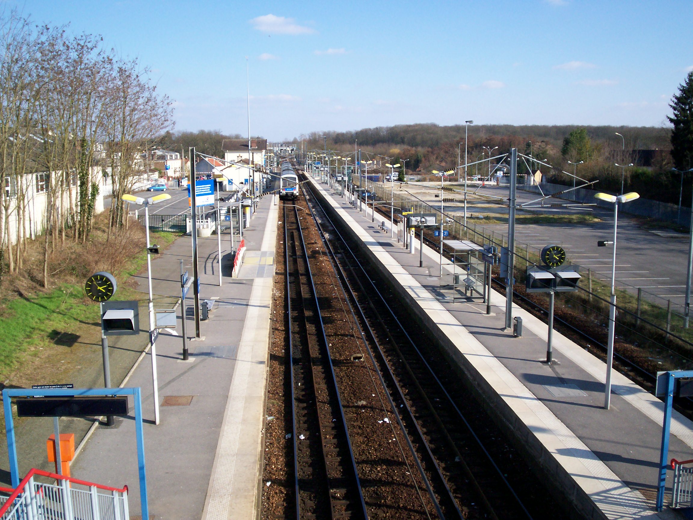
Les Yvris–Noisy-le-Grand Station
Les Yvris–Noisy-le-Grand is a French railway station located at kilometric point 23.843 of the Paris-Est–Mulhouse-Ville railway, on branch E4 of RER E, in Noisy-le-Grand, Seine-Saint-Denis, Île-de-France. The station Opened on Paris–Bâle railway, the station is named after a district of Noisy-le-Grand. It has been served since 14 December 2003 by RER E trains bound to Tournan. It was so far served by suburban trains from Paris-Est. Service The station is served in both directions by one train every 30 minutes at off-peak times and in the evening, and by 2 to 4 trains an hour during peak hours. More than 45 trains a day serving the station travel towards Haussmann–Saint Lazare, while 44 travel towards Tournan. Connections RATP Group RATP may refer to: Transportation: * RATP Group, or ', a public transport operator based in Paris, France * RATP Iași (), a transit operator responsible for public transportation in Iași, Romania * RATP Ploiești (), a tr ... [...More Info...] [...Related Items...] OR: [Wikipedia] [Google] [Baidu] |
Réseau Express Régional
The Réseau Express Régional ( en, Regional Express Network), commonly abbreviated RER (), is a hybrid commuter rail and rapid transit system serving Paris and its Île-de-France, suburbs. It acts as a combined city-centre underground rail system and suburbs-to-city-centre commuter rail. In the city centre it acts much like the Paris Métro, though faster, having fewer stops. This has made it a model for proposals to improve transit within other cities. The network consists of five lines: RER A, A, RER B, B, RER C, C, RER D, D and RER E, E. The network has 257 stations and has interchanges with the Paris Métro, Métro and Transilien, commuter rail within the City of Paris and the suburbs. The lines are identified by letters to avoid confusion with the Métro lines, which are identified by numbers. The network is still expanding: RER E, which opened in 1999, is planned for westward extension toward La Défense and Mantes-la-Jolie in two phases by 2024–2026. Characteristi ... [...More Info...] [...Related Items...] OR: [Wikipedia] [Google] [Baidu] |
SNCF
The Société nationale des chemins de fer français (; abbreviated as SNCF ; French for "National society of French railroads") is France's national state-owned railway company. Founded in 1938, it operates the country's national rail traffic along with Monaco, including the TGV, on France's high-speed rail network. Its functions include operation of railway services for passengers and freight (through its subsidiaries SNCF Voyageurs and Rail Logistics Europe), as well as maintenance and signalling of rail infrastructure (SNCF Réseau). The railway network consists of about of route, of which are high-speed lines and electrified. About 14,000 trains are operated daily. In 2010 the SNCF was ranked 22nd in France and 214th globally on the Fortune Global 500 list. It is the main business of the SNCF Group, which in 2020 had €30 billion of sales in 120 countries. The SNCF Group employs more than 275,000 employees in France and around the world. Since July 2013, the SNCF Grou ... [...More Info...] [...Related Items...] OR: [Wikipedia] [Google] [Baidu] |
Kilometric Point
A milestone is a numbered marker placed on a route such as a road, railway line, canal or boundary. They can indicate the distance to towns, cities, and other places or landmarks; or they can give their position on the route relative to some datum location. On roads they are typically located at the side or in a median or central reservation. They are alternatively known as mile markers, mileposts or mile posts (sometimes abbreviated MPs). A "kilometric point" is a term used in metricated areas, where distances are commonly measured in kilometres instead of miles. "Distance marker" is a generic unit-agnostic term. Milestones are installed to provide linear referencing points along the road. This can be used to reassure travellers that the proper path is being followed, and to indicate either distance travelled or the remaining distance to a destination. Such references are also used by maintenance engineers and emergency services to direct them to specific points where th ... [...More Info...] [...Related Items...] OR: [Wikipedia] [Google] [Baidu] |
Paris-Est–Mulhouse-Ville Railway
The railway from Paris-Est to Mulhouse-Ville is a 491-kilometre long railway line, that connects Paris to Mulhouse via Troyes, Chaumont and Belfort, France. The railway was opened in several stages between 1848 and 1858. Route The Paris–Mulhouse railway leaves the Gare de l'Est in Paris in eastern direction. At Noisy-le-Sec, where the Paris–Strasbourg railway branches off, it turns south. It crosses the river Marne at Nogent-sur-Marne, and turns southeast. Near Gouaix it reaches the river Seine, and follows this river upstream, until Nogent-sur-Seine on its right bank, then on its left bank, roughly southeastward. At Troyes it crosses the Seine again, and turns east. It enters the Aube valley near Jessains, and continues upstream along Bar-sur-Aube. It leaves the Aube and enters the upper Marne valley at Chaumont. It passes Langres and the railway junction Culmont-Chalindrey, where it crosses the line Nancy–Dijon. It reaches the river Saône at Jussey, and follows it dow ... [...More Info...] [...Related Items...] OR: [Wikipedia] [Google] [Baidu] |
RER E
RER E is one of the five lines in the Réseau Express Régional (English: Regional Express Network), a hybrid commuter rail and rapid transit system serving Paris, France and its suburbs. The RER E line travels between Paris and eastern suburbs, with all trains serving the stations in central Paris, before branching out towards the ends of the line. The line runs from the western terminus Haussmann–Saint-Lazare (E1) to the eastern termini Chelles–Gournay (E2) and Tournan (E4). It is operated by SNCF. Originally referred to as the Est Ouest Liaison Express or EOLE (English: East West Express Link), RER E is the newest line in the system opening in 1999, with the extension in 2003, and further extensions to the west currently under construction (in 2024 to Nanterre-La Folie, in 2026 to Mantes-la-Jolie). History RER E opened on 14 July 1999 between Haussmann – Saint-Lazare and Chelles–Gournay. The construction included a tunnel between Haussmann – St-Lazare and ... [...More Info...] [...Related Items...] OR: [Wikipedia] [Google] [Baidu] |
Noisy-le-Grand
Noisy-le-Grand () is a commune in the eastern suburbs of Paris, France. It is located from the centre of Paris. The commune of Noisy-le-Grand is part of the sector of Porte de Paris, one of the four sectors of the "new town" of Marne-la-Vallée. Some of the postmodern architecture in the commune has been used as a shooting location in movies including ''Brazil'' and ''The Hunger Games''. Name The name Noisy comes from Medieval Latin ''nucetum'', meaning "walnut grove", after the walnut trees () covering the territory of Noisy-le-Grand in ancient times. The epithet "le-Grand" (Medieval Latin: ''Magnum''), meaning "the Great", was added in the Middle Ages, probably to distinguish Noisy-le-Grand from the smaller settlement of Noisy-le-Sec, which was sometimes referred to as ''Nucenum Minus'' ("Noisy the Small"). Demographics Like a lot of other Seine-Saint-Denis cities, the commune is very cosmopolitan, home of many communities, with a lot of its locals coming from various cont ... [...More Info...] [...Related Items...] OR: [Wikipedia] [Google] [Baidu] |
Seine-Saint-Denis
() is a department of France located in the Grand Paris metropolis in the region. In French, it is often referred to colloquially as ' or ' ("ninety-three" or "nine three"), after its official administrative number, 93. Its prefecture is Bobigny. In 2019, it had a population of 1,644,903 across 40 communes.Populations légales 2019: 93 Seine-Saint-Denis INSEE In French, the learned but rarely used demonym for the inhabitants of Seine-Saint-Denis is ; more common is . Geography The department is surrounded by the departments of Hauts-de-Seine, |
Île-de-France
, timezone1 = CET , utc_offset1 = +01:00 , timezone1_DST = CEST , utc_offset1_DST = +02:00 , blank_name_sec1 = Gross regional product , blank_info_sec1 = Ranked 1st , blank1_name_sec1 = –Total , blank1_info_sec1 = €742 billion (2019) , blank2_name_sec1 = –Per capita , blank2_info_sec1 = €59,400 (2018) , blank_name_sec2 = NUTS Region , blank_info_sec2 = FR1 , website = , iso_code = FR-IDF , footnotes = The Île-de-France (, ; literally "Isle of France") is the most populous of the eighteen regions of France. Centred on the capital Paris, it is located in the north-central part of the country and often called the ''Région parisienne'' (; en, Paris Region). Île-de-France is densely populated and retains a prime economic position on the national stage: though it covers only , abo ... [...More Info...] [...Related Items...] OR: [Wikipedia] [Google] [Baidu] |
Tournan Station
Tournan station ( French: ''Gare de Tournan'') is a hub in the French transport network enabling travellers to reach the region around Tournan-en-Brie (Seine-et-Marne, Ile-de-France). This place provides an easy connection to other forms of road transport. It is a railway station serving the town Tournan-en-Brie, Seine-et-Marne department, northern France. It is on the line from Gretz-Armainvilliers to Sézanne. See also * List of Réseau Express Régional stations * List of SNCF stations in Île-de-France * List of Transilien stations The following is a list of all stations of the Transilien network. RER stations are not included in this list; see the separate list of RER stations. Tram stops ( line 4 and line 11 Express) are not included in this list; see the separate L ... External links * Réseau Express Régional stations Railway stations in Seine-et-Marne Railway stations in France opened in 1861 {{IledeFrance-railstation-stub ... [...More Info...] [...Related Items...] OR: [Wikipedia] [Google] [Baidu] |
Gare De L'Est
The Gare de l'Est (; English: "Station of the East" or "East station"), officially Paris-Est, is one of the six large mainline railway station termini in Paris, France. It is located in the 10th arrondissement, not far southeast from the Gare du Nord, facing the Boulevard de Strasbourg, part of the north-south axis of Paris created by Georges-Eugène Haussmann. Opened in 1849, it is currently the fifth-busiest of the six main railway stations in Paris before the Gare d'Austerlitz. The Gare de l'Est is the western terminus of the Paris–Strasbourg railway and Paris–Mulhouse railway which then proceeds to Basel, Switzerland. History The Gare de l'Est was opened in 1849 by the Compagnie du Chemin de Fer de Paris à Strasbourg (Paris–Strasbourg Railway Company) under the name "Strasbourg platform" (''Embarcadère de Strasbourg''); an official inauguration with President Louis Napoléon Bonaparte took place the next year. The platform corresponds today with the hall for ... [...More Info...] [...Related Items...] OR: [Wikipedia] [Google] [Baidu] |
RATP Group
RATP may refer to: Transportation: * RATP Group, or ', a public transport operator based in Paris, France * RATP Iași (), a transit operator responsible for public transportation in Iași, Romania * RATP Ploiești (), a transit operator responsible for public transportation in Ploiești Ploiești ( , , ), formerly spelled Ploești, is a city and county seat in Prahova County, Romania. Part of the historical region of Muntenia, it is located north of Bucharest. The area of Ploiești is around , and it borders the Blejoi commu ..., Romania Computation: * Reliable Asynchronous Transfer Protocol (RATP), defined in RFC 916 {{Disambiguation ... [...More Info...] [...Related Items...] OR: [Wikipedia] [Google] [Baidu] |


