|
Lekhapani Railway Station
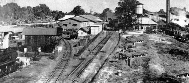
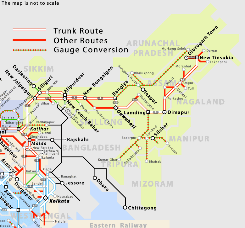
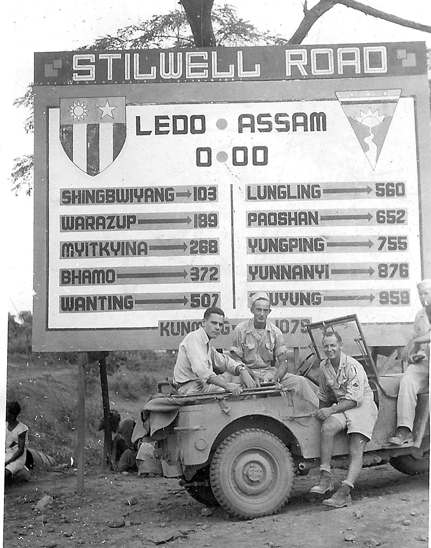
Lekhapani is a railway station on the Lumding–Dibrugarh section. It is located in Tinsukia district in the Indian state of Assam. History Lekhapani railway station, opened around 1890, was a major coal-loading point for Tipong collieries. There is a display tablet at the station which says that the station was closed to commercial traffic in 1993 and the last train ran on the line in 1997. The railway station was restored in 2009. Lekhapani used to be the easternmost railway station of Indian Railways. When gauge conversions took place around 1997, Ledo became the last and the easternmost station. The broad gauge continued up to Tirap for railway sidings. Beyond that the remnants of the -wide metre-gauge track to Lekhapani was visible (as of 2005). Stillwell Road Lekhapani was the starting point of the Stillwell Road constructed by the Allied forces in 1942–45 through Burma to Kunming in China. New line surveys Surveys are underway for -long line from Tirap t ... [...More Info...] [...Related Items...] OR: [Wikipedia] [Google] [Baidu] |
Indian Railways
Indian Railways (IR) is a statutory body under the ownership of Ministry of Railways, Government of India that operates India's national railway system. It manages the fourth largest national railway system in the world by size, with a total route length of . or 83% of all the broad-gauge routes are electrified with 25 kV 50 Hz AC electric traction . In 2020, Indian Railways carried 808.6 crore (8.086 billion) passengers and in 2022, Railways transported 1418.1 million tonnes of freight. It runs 13,169 passenger trains daily, on both long-distance and suburban routes, covering 7,325 stations across India. Mail or Express trains, the most common types of trains, run at an average speed of . Suburban EMUs run at an average speed of . Ordinary passenger trains (incl. mixed) run at an average speed of . The maximum speed of passenger trains varies, with the Vande Bharat Express running at a peak speed of . In the freight segment, IR runs 8,479 trains daily. The a ... [...More Info...] [...Related Items...] OR: [Wikipedia] [Google] [Baidu] |
Lumding–Dibrugarh Section
The Lumding–Dibrugarh section is a broad-gauge railway line connecting and . The -long railway line is functional in the Indian state of Assam. It is under the jurisdiction of Northeast Frontier Railway. History The Assam Railway and Trading Company Limited was incorporated in 1881. The first metre-gauge locomotive was put into service in Assam in 1882. The -long line from Dibrugarh steamer ghat to Makum was opened to passenger traffic on 16 July 1883. The objective of opening an isolated railway in upper Assam was to link the tea gardens and coalfields to the steamer ghats. In the latter part of the 19th century, the Dibru–Sadiya railway was long.''Urban History of India: A Case-Study'' by Deepali Barua, pages 79-80, , Mittal Publications, A-110 Mohan Garden, New Delhi – 110059 The -wide metre-gauge railway track earlier laid by Assam Bengal Railway from Chittagong to Lumding was extended to Tinsukia on the Dibru–Sadiya line in 1903. The Mariani–Furkating line wa ... [...More Info...] [...Related Items...] OR: [Wikipedia] [Google] [Baidu] |
Northeast Frontier Railway Zone
The Northeast Frontier Railway (abbreviated NFR) is one of the Zones and divisions of Indian Railways, 19 railway zones of the Indian Railways. It is headquartered in Maligaon, Guwahati in the state of Assam, and responsible for operation and expansion of rail network all across Northeast India, Northeastern states and some districts of eastern Bihar and northern West Bengal. Divisions Northeast Frontier Railway is divided into 5 divisions: * Katihar railway division * Alipurduar railway division * Lumding railway division * Rangiya railway division * Tinsukia railway division Each of these divisions is headed by a Divisional Railway Manager, a Senior Administrative Grade officer of the rank of Joint Secretary to Government of India. The departmental setup at headquarters level and divisional setup in the field assists the General Manager in running the railways. Various departments namely engineering, mechanical, electrical, signal & telecom, operations, commercial, safety, acc ... [...More Info...] [...Related Items...] OR: [Wikipedia] [Google] [Baidu] |
Tinsukia District
Tinsukia district () is one of the 34 administrative districts in the state of Assam, India. The district headquarters is located at Tinsukia city. The district occupies an area of 3790 km2. Towns *Digboi *Doom Dooma, Doomdooma *Jagun *Kakopathar *Lido Town *Makum *Margherita *Sadiya *Tinsukia History The area of the present district was an integral part of the Chutiya kingdom during the medieval period. After the defeat of the Chutias, the Ahoms placed ''Sadiya-khowa gohain'' to rule the region. Later, the Matak rajya, Matak kingdom rose in its place after the Moamoria rebellion. The older name of Tinsukia city was ''Bengmara''. It was later made the capital of the Motok Kingdom when a member of the former Chutiya kingdom, Chutia royal family named Sarbananada Singha established his capital at Rangagarh situated in the bank of river Guijan. In 1791 AD, he transferred his capital to the city of Bengmara. Bengmara was built by King Sarbananda Singha with the help of his Min ... [...More Info...] [...Related Items...] OR: [Wikipedia] [Google] [Baidu] |
Assam
Assam (; ) is a state in northeastern India, south of the eastern Himalayas along the Brahmaputra and Barak River valleys. Assam covers an area of . The state is bordered by Bhutan and Arunachal Pradesh to the north; Nagaland and Manipur to the east; Meghalaya, Tripura, Mizoram and Bangladesh to the south; and West Bengal to the west via the Siliguri Corridor, a wide strip of land that connects the state to the rest of India. Assamese and Boro are the official languages of Assam, while Bengali is an additional official language in the Barak Valley. Assam is known for Assam tea and Assam silk. The state was the first site for oil drilling in Asia. Assam is home to the one-horned Indian rhinoceros, along with the wild water buffalo, pygmy hog, tiger and various species of Asiatic birds, and provides one of the last wild habitats for the Asian elephant. The Assamese economy is aided by wildlife tourism to Kaziranga National Park and Manas National Park, which are ... [...More Info...] [...Related Items...] OR: [Wikipedia] [Google] [Baidu] |
Ledo Assam (41)
Ledo may refer to: * Ledo, Assam, India, a town * Ledo, Jharkhand, India, a village and former Zamindari Gadi in pergana Kharagdiha * Ledo Airfield, a World War II United States Army Air Forces airfield in India * Ledo Road, a World War II road connecting Ledo, India, to Kunming, China * Ledo Pizza, an American restaurant chain * Ledo (company) Ledo d.d. is a Croatian-based producer of ice cream and frozen food headquartered in Zagreb. Ledo's total revenues in 2008 amounted to HRK 1.19 billion and increased by 16.7 percent compared to last year. The bulk of the income is made up of sal ..., a Croatian ice cream producer * Ledo (name), a list of people with the surname or given name See also * Lido (other) {{disambig, geo ... [...More Info...] [...Related Items...] OR: [Wikipedia] [Google] [Baidu] |
Ledo Assam (45)
Ledo may refer to: * Ledo, Assam, India, a town * Ledo, Jharkhand, India, a village and former Zamindari Gadi in pergana Kharagdiha * Ledo Airfield, a World War II United States Army Air Forces airfield in India * Ledo Road, a World War II road connecting Ledo, India, to Kunming, China * Ledo Pizza, an American restaurant chain * Ledo (company) Ledo d.d. is a Croatian-based producer of ice cream and frozen food headquartered in Zagreb. Ledo's total revenues in 2008 amounted to HRK 1.19 billion and increased by 16.7 percent compared to last year. The bulk of the income is made up of sal ..., a Croatian ice cream producer * Ledo (name), a list of people with the surname or given name See also * Lido (other) {{disambig, geo ... [...More Info...] [...Related Items...] OR: [Wikipedia] [Google] [Baidu] |
Broad Gauge
A broad-gauge railway is a railway with a track gauge (the distance between the rails) broader than the used by standard-gauge railways. Broad gauge of , commonly known as Russian gauge, is the dominant track gauge in former Soviet Union (CIS states, Baltic states, Georgia and Ukraine), Mongolia and Finland. Broad gauge of , commonly known as Irish Gauge, is the dominant track gauge in Ireland, and the Australian states of Victoria and Adelaide. Broad gauge of , commonly known as Iberian gauge, is the dominant track gauge in Spain and Portugal. Broad gauge of , commonly known as Indian gauge, is the dominant track gauge in India, Pakistan, Bangladesh, Sri Lanka, Argentina, Chile, and on BART (Bay Area Rapid Transit) in the San Francisco Bay Area. This is the widest gauge in common use anywhere in the world. It is possible for trains on both Iberian gauge and Indian gauge to travel on each other's tracks with no modifications in the vast majority of cases. History In Gr ... [...More Info...] [...Related Items...] OR: [Wikipedia] [Google] [Baidu] |
Metre-gauge
Metre-gauge railways are narrow-gauge railways with track gauge of or 1 metre. The metre gauge is used in around of tracks around the world. It was used by European colonial powers, such as the French, British and German Empires. In Europe, large metre-gauge networks remain in use in Switzerland, Spain and many European towns with urban trams, but most metre-gauge local railways in France, Germany and Belgium closed down in the mid-20th century, although many still remain. With the revival of urban rail transport, metre-gauge light metros were established in some cities, and in other cities, metre gauge was replaced by standard gauge. The slightly-wider gauge is used in Sofia. Examples of metre-gauge See also * Italian metre gauge * Narrow-gauge railways A narrow-gauge railway (narrow-gauge railroad in the US) is a railway with a track gauge narrower than standard . Most narrow-gauge railways are between and . Since narrow-gauge railways are usually built with ... [...More Info...] [...Related Items...] OR: [Wikipedia] [Google] [Baidu] |
Stillwell Road
The Ledo Road (from Ledo, Assam, India to Kunming, Yunnan, China) was an overland connection between India and China, built during World War II to enable the Western Allies to deliver supplies to China and aid the war effort against Japan. After the Japanese cut off the Burma Road in 1942 an alternative was required, hence the construction of the Ledo Road. It was renamed the Stilwell Road, after General Joseph Stilwell of the U.S. Army, in early 1945 at the suggestion of Chiang Kai-shek. It passes through the Burmese towns of Shingbwiyang, Myitkyina and Bhamo in Kachin state. Of the long road, are in Burma and in China with the remainder in India. The road had the Ledo-Pangsau Pass-Tanai (Danai)-Myitkyina--Bhamo-Mansi- Namhkam-Kunming route. To move supplies from the railheads to the Army fronts, three all-weather roads were constructed in record time during the autumn (fall) of 1943: Ledo Road in the north across three nations, which went on to connect to the Bur ... [...More Info...] [...Related Items...] OR: [Wikipedia] [Google] [Baidu] |
Kunming
Kunming (; ), also known as Yunnan-Fu, is the capital and largest city of Yunnan province, China. It is the political, economic, communications and cultural centre of the province as well as the seat of the provincial government. The headquarters of many of Yunnan's large businesses are in Kunming. It was important during World War II as a Chinese military center, American air base, and transport terminus for the Burma Road. In the middle of the Yunnan–Guizhou Plateau, Kunming is at an altitude of above sea level and a latitude just north of the Tropic of Cancer. As of 2020 census, Kunming had a total population of 8,460,088 inhabitants, of whom 5,604,310 lived in its built-up (or metro) area made of all urban districts but Jinning, not conurbated yet. It is at the northern edge of Dian Lake, surrounded by temples and lake-and-limestone hill landscapes. Kunming consists of an old, previously walled city, a modern commercial district, residential zones and university areas. ... [...More Info...] [...Related Items...] OR: [Wikipedia] [Google] [Baidu] |
Arunachal Pradesh
Arunachal Pradesh (, ) is a state in Northeastern India. It was formed from the erstwhile North-East Frontier Agency (NEFA) region, and became a state on 20 February 1987. It borders the states of Assam and Nagaland to the south. It shares international borders with Bhutan in the west, Myanmar in the east, and a disputed border with China in the north at the McMahon Line. Itanagar is the state capital of Arunachal Pradesh. Arunachal Pradesh is the largest of the Seven Sister States of Northeast India by area. Arunachal Pradesh shares a 1,129 km border with China's Tibet Autonomous Region. As of the 2011 Census of India, Arunachal Pradesh has a population of 1,382,611 and an area of . It is an ethnically diverse state, with predominantly Monpa people in the west, Tani people in the centre, Mishmi and Tai people in the east, and Naga people in the southeast of the state. About 26 major tribes and 100 sub-tribes live in the state. The main tribes of the state are Adi, Nyshi ... [...More Info...] [...Related Items...] OR: [Wikipedia] [Google] [Baidu] |


.jpg)