|
Laterculus Veronensis
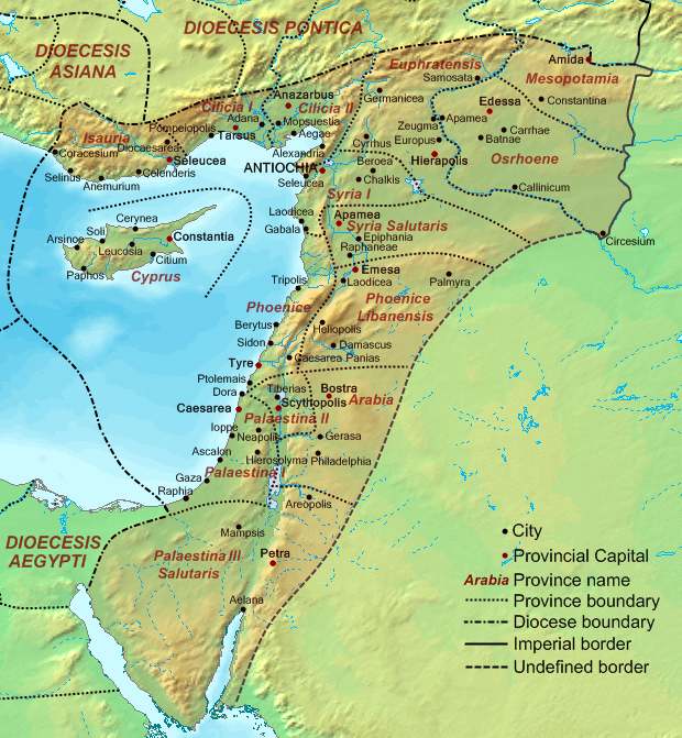
The ''Laterculus Veronensis'' or Verona List is a list of Roman provinces and barbarian peoples from the time of the emperors Diocletian and Constantine I, most likely from AD 314. The list is transmitted only in a 7th-century manuscript preserved in the Chapter Library of Verona. The most recent critical edition is that of Timothy Barnes (1982). Earlier editions include those by Theodor Mommsen (1862), Otto Seeck in his edition of the ''Notitia dignitatum'' (1876), and Alexander Riese in his ''Geographi Latini minores'' (1878). Description The document comprises a list of the names of all the provinces of the empire (c. 100 in total), organised according to the twelve newly created regional groupings called dioceses. Although the dioceses are presented in a single list, they are not ordered in a single geographical sequence but rather in two separate eastern and western groups, the eastern group (Oriens, Pontica, Asiana, Thraciae, Moesiae, Pannoniae) preceding the western (Brit ... [...More Info...] [...Related Items...] OR: [Wikipedia] [Google] [Baidu] |
Roman Provinces
The Roman provinces (Latin: ''provincia'', pl. ''provinciae'') were the administrative regions of Ancient Rome In modern historiography, ancient Rome refers to Roman civilisation from the founding of the city of Rome in the 8th century BC to the collapse of the Western Roman Empire in the 5th century AD. It encompasses the Roman Kingdom (753–509 B ... outside Roman Italy that were controlled by the Romans under the Roman Republic and later the Roman Empire. Each province was ruled by a Roman appointed as Roman governor, governor. For centuries it was the largest administrative unit of the foreign possessions of ancient Rome. With the administrative reform initiated by Diocletian, it became a third level administrative subdivision of the Roman Empire, or rather a subdivision of the Roman diocese, imperial dioceses (in turn subdivisions of the Praetorian prefect, imperial prefectures). Terminology The English language, English word ''province'' comes from the Latin w ... [...More Info...] [...Related Items...] OR: [Wikipedia] [Google] [Baidu] |
Libya Superior
Cyrenaica ( ) or Kyrenaika ( ar, برقة, Barqah, grc-koi, Κυρηναϊκή ��παρχίαKurēnaïkḗ parkhíā}, after the city of Cyrene), is the eastern region of Libya. Cyrenaica includes all of the eastern part of Libya between longitudes E16 and E25, including the Kufra District. The coastal region, also known as '' Pentapolis'' ("Five Cities") in antiquity, was part of the Roman province of Crete and Cyrenaica, later divided into ''Libya Pentapolis'' and ''Libya Sicca''. During the Islamic period, the area came to be known as ''Barqa'', after the city of Barca. Cyrenaica became an Italian colony in 1911. After the 1934 formation of Libya, the Cyrenaica province was designated as one of the three primary provinces of the country. During World War II, it fell under British military and civil administration from 1943 until 1951, and finally in the Kingdom of Libya from 1951 until 1963. The region that used to be Cyrenaica officially until 1963 has formed seve ... [...More Info...] [...Related Items...] OR: [Wikipedia] [Google] [Baidu] |
Isauria
Isauria ( or ; grc, Ἰσαυρία), in ancient geography, is a rugged, isolated, district in the interior of Asia Minor, of very different extent at different periods, but generally covering what is now the district of Bozkır and its surroundings in the Konya Province of Turkey, or the core of the Taurus Mountains. In its coastal extension it bordered on Cilicia. It derives its name from the contentious Isaurian tribe and twin settlements ''Isaura Palaea'' (Ἰσαυρα Παλαιά, Latin: ''Isaura Vetus'' 'Old Isaura') and ''Isaura Nea'' (Ἰσαυρα Νέα, Latin: ''Isaura Nova'' 'New Isaura'). Isaurian marauders were fiercely independent mountain people who created havoc in neighboring districts under Macedonian and Roman occupations. History Early The permanent nucleus of Isauria was north of the Taurus range which lies directly to south of Iconium and Lystra. Lycaonia had all the Iconian plain; but Isauria began as soon as the foothills were reached. Its ... [...More Info...] [...Related Items...] OR: [Wikipedia] [Google] [Baidu] |
Cilicia
Cilicia (); el, Κιλικία, ''Kilikía''; Middle Persian: ''klkyʾy'' (''Klikiyā''); Parthian: ''kylkyʾ'' (''Kilikiyā''); tr, Kilikya). is a geographical region in southern Anatolia in Turkey, extending inland from the northeastern coasts of the Mediterranean Sea. Cilicia has a population ranging over six million, concentrated mostly at the Cilicia plain. The region includes the provinces of Mersin, Adana, Osmaniye, along with parts of Hatay and Antalya. Geography Cilicia is extended along the Mediterranean coast east from Pamphylia to the Nur Mountains, which separates it from Syria. North and east of Cilicia lie the rugged Taurus Mountains that separate it from the high central plateau of Anatolia, which are pierced by a narrow gorge called in antiquity the Cilician Gates. Ancient Cilicia was naturally divided into Cilicia Trachea and Cilicia Pedias by the Limonlu River. Salamis, the city on the east coast of Cyprus, was included in its administrative jurisdiction. T ... [...More Info...] [...Related Items...] OR: [Wikipedia] [Google] [Baidu] |
Augusta Euphratensis
Euphratensis ( Latin for " Euphratean"; grc-gre, Εὑφρατησία, ''Euphratēsía''), fully Augusta Euphratensis, was a late Roman and then Byzantine province in Syrian region, part of the Byzantine Diocese of the East. History Sometime between 330 and 350 AD (likely ), the Roman province of ''Euphratensis'' was created out of the territory of Coele Syria along the western bank of the Euphrates. It included the territories of Commagene and Cyrrhestice. Its capital was CyrrusEdmund Spenser Bouchier, ''Syria as a Roman Province'', 1916p. 155/ref> or perhaps Hierapolis Bambyce. It remained within the Byzantine Empire following the 395 division of the empire by Theodosius I. The province is listed in the Laterculus Veronensis from around 314. The Roman Catholic and Orthodox saints Sergius and Bacchus were supposedly martyred in the city of Resafa Resafa ( ar, الرصافة Reṣafa), also sometimes spelled Rusafa, and known in the Byzantine era as Sergiopolis (in g ... [...More Info...] [...Related Items...] OR: [Wikipedia] [Google] [Baidu] |
Syria Coele
Coele-Syria (, also spelt Coele Syria, Coelesyria, Celesyria) alternatively Coelo-Syria or Coelosyria (; grc-gre, Κοίλη Συρία, ''Koílē Syría'', 'Hollow Syria'; lat, Cœlē Syria or ), was a region of Syria (region), Syria in classical antiquity. It probably derived from the Aramaic word for all of the Syria (region), region of Syria, but it was most often applied to the Beqaa Valley between the Mount Lebanon, Lebanon and the Anti-Lebanon Mountains, Anti-Lebanon mountain ranges. The area is now part of the modern-day Syria and Lebanon. Name It is widely accepted that the term Coele is a transcription of Aramaic ''kul'', meaning "all, the entire", such that the term originally identified ''all'' of Syria.A History of the ... [...More Info...] [...Related Items...] OR: [Wikipedia] [Google] [Baidu] |
Phoenice
Phoenice or Phoenike ( el, Φοινίκη) was an ancient Greek city in Epirus and capital of the Chaonians.: "To the north the Chaonians had expelled the Corcyraeans from their holdings on the mainland and built fortifications at Buthrotum, Kalivo and Kara-Ali-Bey; and they had a citadel at their political centre, Phoenice.". It was also the location of the Treaty of Phoenice which ended the First Macedonian War, as well as one of the wealthiest cities in Epirus until the Roman conquest.. During the early Byzantine period, Phoenice was the see of a bishopric. The city is an archaeological park of Albania and is located on a hill above a modern town which bears the same name, Finiq, in modern southern Albania. Toponym The toponym is ultimately of non-Indo-European origin, as with all names with an -īk suffix in IE languages. There were at least 16 toponyms throughout the Ancient Greek world sharing the root ''Phoinik-''; from Epirus to Lycia. In ancient Greek, φοῖνιξ ( ... [...More Info...] [...Related Items...] OR: [Wikipedia] [Google] [Baidu] |
Syria Palaestina
Syria Palaestina (literally, "Palestinian Syria";Trevor Bryce, 2009, ''The Routledge Handbook of the Peoples and Places of Ancient Western Asia''Roland de Vaux, 1978, ''The Early History of Israel'', Page 2: "After the revolt of Bar Cochba in 135, the Roman province of Judaea was renamed Palestinian Syria." la, Syria Palaestina ; grc-koi, Συρία ἡ Παλαιστίνη, Syría hē Palaistínē, ) was a Roman province in the Palestine (region), Palestine region between the early 2nd and late 4th centuries AD. It resulted from the merging of the Judaea (Roman province), province of Judaea with Galilee, in 132 AD, into an enlarged province named "Syria Palaestina". Its capital was Caesarea Maritima. Background Judaea was a Roman province which incorporated the regions of Judea, Samaria, and Idumea, and extended over parts of the former regions of the Hasmonean and Herodian kingdom, Herodian kingdoms of Judea. It was named after Herod Archelaus's Herodian Tetrarchy, Tetrarch ... [...More Info...] [...Related Items...] OR: [Wikipedia] [Google] [Baidu] |
Augusta Libanensis
Phoenice Libanensis (, also known in Latin as Phoenice Libani), or Phoenice II/Phoenice Secunda), was a province of the Roman Empire, covering the Anti-Lebanon Mountains and the territories to the east, all the way to Palmyra. It was officially created , when the Roman province of Phoenice was divided into Phoenice proper or ''Phoenice Paralia'', and Phoenice Libanensis, a division that persisted until the region was conquered by the Muslim Arabs in the 630s. Toponymy Agapius of Hierapolis used the term “''wilderness of Phoenicia''” to refer to the steppe between Emesa and Palmyra, in the former province of Lebanese Phoenicia. During the Crusades, William of Tyre and Jacques of Vitry mention Lebanese Phoenicia in its Graeco-Roman borders and limits, undoubtedly based on the administrative and ecclesiastical geographies still known in the Roman Empire. William of Tyre goes on to call Damascus the “metropolis of Little Syria, otherwise called Lebanese Phoenicia” ... [...More Info...] [...Related Items...] OR: [Wikipedia] [Google] [Baidu] |
Arabia Petraea
Arabia Petraea or Petrea, also known as Rome's Arabian Province ( la, Provincia Arabia; ar, العربية البترائية; grc, Ἐπαρχία Πετραίας Ἀραβίας) or simply Arabia, was a frontier province of the Roman Empire beginning in the 2nd century. It consisted of the former Nabataean Kingdom in Jordan, southern Levant, the Sinai Peninsula and northwestern Arabian Peninsula. Its capital was Petra. It was bordered on the north by Syria, on the west by Judaea (merged with Syria from AD 135) and Egypt, and on the south and east by the rest of Arabia, known as Arabia Deserta and Arabia Felix. The territory was annexed by Emperor Trajan, like many other eastern frontier provinces of the Roman Empire, but held onto, unlike Armenia, Mesopotamia and Assyria, well after Trajan's rule, its desert frontier being called the Limes Arabicus. It produced the Emperor Philippus, who was born around 204. As a frontier province, it included a desert populated by Arabic ... [...More Info...] [...Related Items...] OR: [Wikipedia] [Google] [Baidu] |
Arabia Nova
, conventional_long_name = Roman Egypt , common_name = Egypt , subdivision = Province , nation = the Roman Empire , era = Late antiquity , capital = Alexandria , title_leader = Praefectus Augustalis , image_map = Roman Empire - Aegyptus (125 AD).svg , image_map_caption = Province of Aegyptus in AD 125 , year_start = 30 BC , event_start = Conquest of Ptolemaic Kingdom , event1 = Formation of the Diocese , date_event1 = 390 , year_end = 641 , event_end = Muslim conquest , life_span = 30 BC – 641 AD , stat_year1 = 1st century AD , stat_pop1 = . , today = Egypt , p1 = Ptolemaic Kingdom , flag_p1 = Ptolemaic-Empire 200bc.jpg , s1 = Sasanian Egypt , flag_s1 = Derafsh Kaviani flag of the late Sassanid Empire.svg , s2 = Rashidun Caliphate , flag_s2 = Mohammad adil-Rashidun-empire-at-its-peak-close.PNG , demonym= Egypt ( ; ) was a subdivision of the Roman Em ... [...More Info...] [...Related Items...] OR: [Wikipedia] [Google] [Baidu] |
Aegyptus Herculea
, conventional_long_name = Roman Egypt , common_name = Egypt , subdivision = Roman province, Province , nation = the Roman Empire , era = Late antiquity , capital = Alexandria , title_leader = Praefectus Augustalis , image_map = Roman Empire - Aegyptus (125 AD).svg , image_map_caption = Province of Aegyptus in AD 125 , year_start = 30 BC , event_start = Conquest of Ptolemaic Kingdom , event1 = Formation of the Diocese of Egypt, Diocese , date_event1 = 390 , year_end = 641 , event_end = Muslim conquest of Egypt, Muslim conquest , life_span = 30 BC – 641 AD , stat_year1 = 1st century AD , stat_pop1 = . , today = Egypt , p1 = Ptolemaic Kingdom , flag_p1 = Ptolemaic-Empire 200bc.jpg , s1 = Sasanian Egypt , flag_s1 = Derafsh Kaviani flag of the late Sassanid Empire.svg , s2 = Rashidun Caliphate , flag_s2 = Mohammad adil-Rashidun-empire-at-its-peak-close.PNG , demon ... [...More Info...] [...Related Items...] OR: [Wikipedia] [Google] [Baidu] |


.jpg)