|
Lambton Mills
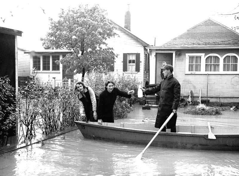
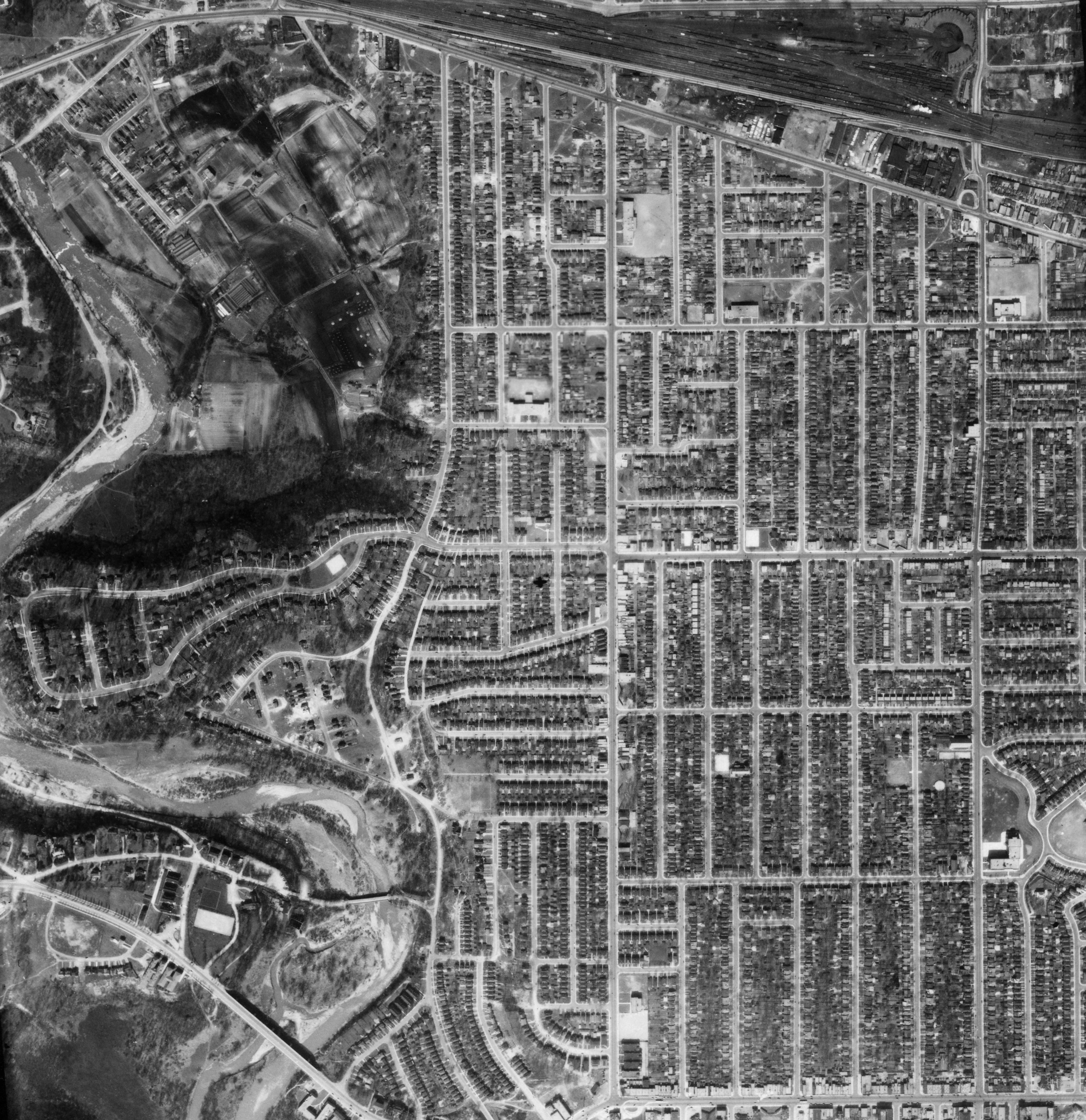
The Village of Lambton Mills was a settlement at the crossing of Dundas Street and the Humber River. The settlement was on both sides of the Humber River, in both the former Etobicoke Township and York Township, within today's City of Toronto, Ontario, Canada. It extended as far west as Royal York Road at Dundas, as far north as the still-existing CPR rail line north of Dundas, as far east as Scarlett Road and as far south as today's Queen Anne Road. The area on the east side of the river is still known as Lambton, although the current neighbourhood encompasses very little of the original Lambton Mills village. History The crossing at the Humber dates to pre-European times. It was the crossing of the 'Davenport Trail' and the 'Toronto Carrying Place' trail used by local First Nations. The name was linked to the mills (grist, saw mills, woolen mills) that operated along the Humber River from 1850 to 1915. Originally called Cooper's Mills (c. 1806) after William Cooper's Grist an ... [...More Info...] [...Related Items...] OR: [Wikipedia] [Google] [Baidu] |
Humber River (Ontario)
The Humber River ( oj, Gabekanaang-ziibi, p=Gabekanaang-ziibi, ''meaning: "little thundering waters"'') is a river in Southern Ontario, Canada. It is in the Great Lakes Basin, is a tributary of Lake Ontario and is one of two major rivers on either side of the city of Toronto, the other being the Don River to the east. It was designated a Canadian Heritage River on September 24, 1999. The Humber collects from about 750 creeks and tributaries in a fan-shaped area north of Toronto that encompasses portions of Dufferin County, the Regional Municipality of Peel, Simcoe County, and the Regional Municipality of York. The main branch runs for about from the Niagara Escarpment in the northwest, while another major branch, known as the East Humber River, starts at Lake St. George in the Oak Ridges Moraine near Aurora to the northeast. They join north of Toronto and then flow in a generally southeasterly direction into Lake Ontario at what was once the far western portions of the city. Show ... [...More Info...] [...Related Items...] OR: [Wikipedia] [Google] [Baidu] |
Canadian Pacific Railway
The Canadian Pacific Railway (french: Chemin de fer Canadien Pacifique) , also known simply as CPR or Canadian Pacific and formerly as CP Rail (1968–1996), is a Canadian Class I railway incorporated in 1881. The railway is owned by Canadian Pacific Railway Limited, which began operations as legal owner in a corporate restructuring in 2001. Headquartered in Calgary, Alberta, the railway owns approximately of track in seven provinces of Canada and into the United States, stretching from Montreal to Vancouver, and as far north as Edmonton. Its rail network also serves Minneapolis–St. Paul, Milwaukee, Detroit, Chicago, and Albany, New York, in the United States. The railway was first built between eastern Canada and British Columbia between 1881 and 1885 (connecting with Ottawa Valley and Georgian Bay area lines built earlier), fulfilling a commitment extended to British Columbia when it entered Confederation in 1871; the CPR was Canada's first transcontinental railway. ... [...More Info...] [...Related Items...] OR: [Wikipedia] [Google] [Baidu] |
Baby Point
Baby Point is a residential neighbourhood in the York district of Toronto, Ontario, Canada. It is bounded on the west by the Humber River from south of Baby Point Crescent to St. Marks Road, east to Jane Street and Jane Street south to Raymond Avenue and Raymond Avenue west to the Humber. It is within the city-defined neighbourhood of 'Lambton-Baby Point.' Baby Point is within the proximity of Jane station. The neighbourhood was at one time an Iroquois village, called Teiaiagon. The village had a population of 5000 at its peak. The village was burnt to the ground in a French Army attack in 1687. In the 19th century, lawyer James Baby bought the land from the Upper Canada government, which had bought it as part of the Toronto Purchase. The land was developed into the current neighbourhood in the early 20th century. The name is pronounced by locals as "Bobby" or "Babby"to rhyme with tabby or cabbiein an approximation of how James Baby pronounced his surname. History The Baby Poin ... [...More Info...] [...Related Items...] OR: [Wikipedia] [Google] [Baidu] |
Runnymede-Bloor West Village
Runnymede is a neighbourhood in Toronto, Ontario, Canada located north of Bloor Street West between Jane Street and Runnymede Road north to Dundas Street West. It is located directly north of the former village of Swansea and west of the High Park North neighbourhood. The immediate area around Bloor Street is commonly known as Bloor West Village after the shopping area along Bloor Street, whereas the area to the north is considered the Runnymede neighbourhood. Character Houses in this neighbourhood are generally (often American craftsman style) two story brick houses, however renovations are becoming popular and many of the traditional homes are being torn down to create larger, more modern homes. The tree-lined streets in this area, which was annexed by the city of Toronto in 1909 make this a popular residential neighbourhood. Much of its development was originally due to the creation of a streetcar line along Bloor Street, which the TTC later replaced by the Bloor-Danforth ... [...More Info...] [...Related Items...] OR: [Wikipedia] [Google] [Baidu] |
List Of Neighbourhoods In Toronto
The strength and vitality of the many neighbourhoods that make up Toronto, Ontario, Canada has earned the city its unofficial nickname of "the city of neighbourhoods." There are over 140 neighbourhoods officially recognized by the City of Toronto and upwards of 240 official and unofficial neighbourhoods within city limits. The current City of Toronto is the amalgamation of the former Metropolitan Toronto municipalities. These are East York, Etobicoke, North York, Scarborough, Toronto and York, each of which retains a community history. The names of these municipalities are still often used by Toronto residents, sometimes for disambiguation purposes as amalgamation resulted in duplicated street names. The area known as Toronto before the 1998 amalgamation is sometimes called the "old" City of Toronto, and "the core". For administrative purposes, Toronto is divided into four districts: Etobicoke-York, North York, Scarborough and Toronto-East York. The former Toronto district is, ... [...More Info...] [...Related Items...] OR: [Wikipedia] [Google] [Baidu] |
Lambton House
Lambton House is a historic former inn in Toronto, Ontario, Canada. It is the last remaining building from the former village of Lambton Mills along the Humber River. The inn was established in 1847, with its present building erected in 1860. History The original structure was built in 1847, Lambton House was part of the Lambton Mills complex which also included a large grist mill, a saw mill, a woolen mill, stables, a general store and a post office. The brick work was designed, we believe, by architect William Tyrrell, father of cartographer Joseph Tyrrell. The building, and most of the surrounding land, was owned by William Pearce Howland, Ontario's second Lieutenant Governor and a Father of Confederation. He named the area Lambton in honour of John George Lambton, Earl of Durham. The hotel opened in 1848. Located on Dundas Highway, a major route in the late 1800s, the hotel was quite busy, and it became a popular picnic spot around the turn of the century. The house surviv ... [...More Info...] [...Related Items...] OR: [Wikipedia] [Google] [Baidu] |
Lambton-Kingsway Junior Middle School
The Kingsway is a residential neighbourhood in Toronto, Ontario, Canada. It is bounded by Bloor Street to the south, Dundas Street to the north, the Mimico Creek to the west and the Humber River to the east. The neighbourhood was officially known as Kingsway Park, which later became replaced by its nickname, The Kingsway. For planning purposes, the neighbourhood is known by the City of Toronto as "Kingsway South" to differentiate it from a more recent extension of The Kingsway north of Dundas Street. "Kingsway South" is not used by residents, due to confusion with the South Kingsway, a street located east of the Humber River and extending south from Bloor Street. Along with The Bridle Path and Forest Hill, The Kingsway is one of the most affluent areas in Toronto with homes characterized by large stone mansions. Character The neighbourhood is predominantly residential with a mixed-use (commercial and residential) area along Bloor and Dundas Streets. The majority of the housing ... [...More Info...] [...Related Items...] OR: [Wikipedia] [Google] [Baidu] |
Royal York Road
Royal York Road, historically known as Church Street or New Church Street, is a north-south arterial road in Toronto, Ontario, Canada. It is a concession road, 5 concessions (10 km) west of Yonge Street, and runs through many residential neighbourhoods, most notably Mimico and The Kingsway, Toronto, the Kingsway. It is classified as a "minor arterial" road by the city of Toronto. The road begins in the south near the shoreline of Lake Ontario, just south of Lake Shore Blvd. It then travels through the neighbourhoods of Mimico, the Queensway, Sunnylea, the Kingsway, and Humber Valley Village. It also serves as the boundary for two neighbourhoods north of Eglinton Avenue; Richview, Toronto, Richview, and Humber Heights-Westmount, Humber Heights. The road crosses three creeks; Mimico Creek, and two tributaries of the Humber River (Ontario), Humber River; Humber Creek, and Silver Creek. Royal York Road officially ends at Dixon Road, but its alignment continues further north a ... [...More Info...] [...Related Items...] OR: [Wikipedia] [Google] [Baidu] |
Credit Valley Railway
The Credit Valley Railway was a railway located in Ontario, Canada from Toronto to St. Thomas. Chartered in 1871 by Ontario railway magnate George Laidlaw, it operated as an independent company until 1883 when it was leased by the Ontario and Quebec Railway, a Canadian Pacific Railway (CPR) operating company building a network of lines in southern Ontario. The section from Toronto to Woodstock remains in use as the CPR mainline through Ontario, forming portions of what is now the Galt and Windsor Subdivisions. The section from Woodstock to St. Thomas is operated by OSR as a short line railway. The branch to Orangeville is currently operated as the Orangeville Brampton Railway. The Elora branch was abandoned and converted to rail trail use. History Formation Following initial discussions held in Milton and Brampton in 1870, the Credit Valley Railway was incorporated by Act of the Legislative Assembly of Ontario in 1871, authorized to build a railway line from Toronto to Or ... [...More Info...] [...Related Items...] OR: [Wikipedia] [Google] [Baidu] |
Toronto
Toronto ( ; or ) is the capital city of the Canadian province of Ontario. With a recorded population of 2,794,356 in 2021, it is the most populous city in Canada and the fourth most populous city in North America. The city is the anchor of the Golden Horseshoe, an urban agglomeration of 9,765,188 people (as of 2021) surrounding the western end of Lake Ontario, while the Greater Toronto Area proper had a 2021 population of 6,712,341. Toronto is an international centre of business, finance, arts, sports and culture, and is recognized as one of the most multicultural and cosmopolitan cities in the world. Indigenous peoples have travelled through and inhabited the Toronto area, located on a broad sloping plateau interspersed with rivers, deep ravines, and urban forest, for more than 10,000 years. After the broadly disputed Toronto Purchase, when the Mississauga surrendered the area to the British Crown, the British established the town of York in 1793 and later designat ... [...More Info...] [...Related Items...] OR: [Wikipedia] [Google] [Baidu] |


