|
Lake Whittington
Lake Whittington is an oxbow lake located in Bolivar County, Mississippi, and Desha County, Arkansas, United States. The Arkansas-Mississippi border follows the center of the narrow, curving lake. Prior to 1938, the north-south flowing Mississippi River curved east into Mississippi, flowed along Lake Whittington (then called "Bolivar Bend"), and then continued its north-south route. History The town of Bolivar, Mississippi, located on the east shore of Bolivar Bend, was protected by a small levee prior to the Civil War. In 1863, the Union gunboat cut the levee, causing significant flooding to the town and surrounding area. Island No. 76 was located in Bolivar Bend, just north of Bolivar. During the Civil War, the island was used by the Union Army as a woodyard, and a group of freed slaves lived there, cutting and stacking wood. In 1865, the Union transport ship ''James Watson'' ran aground on the island and caught fire, killing 24. The island is now called "Goat Island". ... [...More Info...] [...Related Items...] OR: [Wikipedia] [Google] [Baidu] |
Bolivar County, Mississippi
Bolivar County ( ) is a county located on the western border of the U.S. state of Mississippi. As of the 2020 census, the population was 30,985. Its county seats are Rosedale and Cleveland. The county is named in honor of Simón Bolívar, early 19th-century leader of the liberation of several South American colonies from Spain. The Cleveland, Mississippi, Micropolitan Statistical Area includes all of Bolivar County. It is located in the Mississippi Delta, or Yazoo Basin, of Mississippi. This area was first developed for cotton plantations. Large industrial-scale agricultural operations have reduced the number of farm workers needed, and the population is half of its peak in 1930. Today, soybeans, corn, and rice are also commodity crops. History In 1836, when it was founded, the land was originally choctaw, and was taken for use in agriculture, with some of the most valued land in the state. In 1840, there was only one free black person, 384 free whites, and 971 enslaved pe ... [...More Info...] [...Related Items...] OR: [Wikipedia] [Google] [Baidu] |
Desha County, Arkansas
Desha County ( ) is a county located in the southeast part of the U.S. state of Arkansas, with its eastern border the Mississippi River. At the 2010 census, the population was 13,008. It ranks 56th of Arkansas's 75 counties in terms of population. The county seat is Arkansas City. Located in the Arkansas Delta, Desha County's rivers and fertile soils became prosperous for planters under the cotton-based economy of plantation agriculture in the antebellum years and late 19th century. Still largely rural, it has suffered population losses and economic decline since the mid-20th century. But following widespread farm mechanization, Desha County underwent a demographic and economic transformation. Farm workers left the area because of the lack of work, and there was a decline in population. Farm holdings have been consolidated into industrial style farms and the economy cannot support much activity. In the 21st century, the county is seeking to reverse population and economic losse ... [...More Info...] [...Related Items...] OR: [Wikipedia] [Google] [Baidu] |
Oxbow Lake
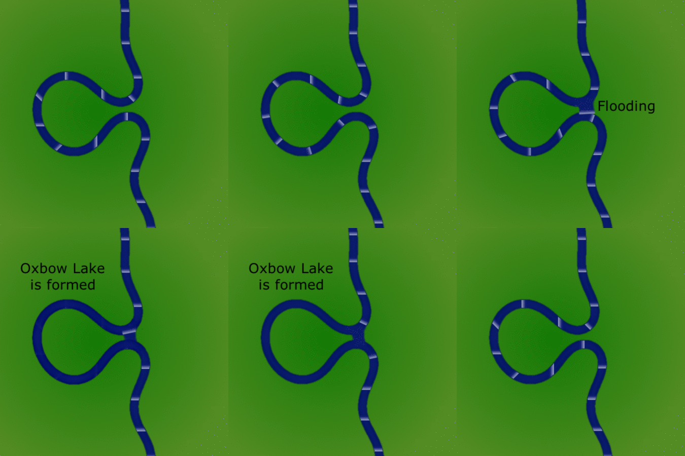
An oxbow lake is a U-shaped lake or pool that forms when a wide meander of a river is cut off, creating a free-standing body of water. In South Texas, oxbows left by the Rio Grande are called '' resacas''. In Australia, oxbow lakes are called billabongs. The word "oxbow" can also refer to a U-shaped bend in a river or stream, whether or not it is cut off from the main stream. Geology An oxbow lake forms when a meandering river erodes through the neck of one of its meanders. This takes place because meanders tend to grow and become more curved over time. The river then follows a shorter course that bypasses the meander. The entrances to the abandoned meander eventually silt up, forming an oxbow lake. Because oxbow lakes are stillwater lakes, with no current flowing through them, the entire lake gradually silts up, becoming a bog or swamp and then evaporating completely. When a river reaches a low-lying plain, often in its final course to the sea or a lake, it meanders wi ... [...More Info...] [...Related Items...] OR: [Wikipedia] [Google] [Baidu] |
Mississippi River
The Mississippi River is the second-longest river and chief river of the second-largest drainage system in North America, second only to the Hudson Bay drainage system. From its traditional source of Lake Itasca in northern Minnesota, it flows generally south for to the Mississippi River Delta in the Gulf of Mexico. With its many tributaries, the Mississippi's watershed drains all or parts of 32 U.S. states and two Canadian provinces between the Rocky and Appalachian mountains. The main stem is entirely within the United States; the total drainage basin is , of which only about one percent is in Canada. The Mississippi ranks as the thirteenth-largest river by discharge in the world. The river either borders or passes through the states of Minnesota, Wisconsin, Iowa, Illinois, Missouri, Kentucky, Tennessee, Arkansas, Mississippi, and Louisiana. Native Americans have lived along the Mississippi River and its tributaries for thousands of years. Most were hunter-ga ... [...More Info...] [...Related Items...] OR: [Wikipedia] [Google] [Baidu] |
Bolivar, Mississippi
Bolivar is a census-designated place and unincorporated community in Bolivar County, Mississippi, United States. Bolivar was once the county seat, and Bolivar Landing was its port on the Mississippi River. Now permanently cut off from the river, Bolivar is a quiescent residential hamlet, while Bolivar Landing, immediately north and across the immense Mississippi Levee, is a cottage community on Lake Whittington. It was first named as a CDP in the 2020 Census which listed a population of 39. History When Bolivar County was established in 1836, the first county seat was located at Bolivar. William Vick sold of land to the county for $800, and it was then named Bolivar. The land was surveyed by B.M. Hines, who laid out the courthouse square, with town lots around it which were advertised for sale. An order was passed by the Board of Police (later called "supervisors") in 1840 to build a one-room courthouse at a cost of $595. In 1844, the Board of Police ordered that the coun ... [...More Info...] [...Related Items...] OR: [Wikipedia] [Google] [Baidu] |
United States Army Corps Of Engineers
, colors = , anniversaries = 16 June (Organization Day) , battles = , battles_label = Wars , website = , commander1 = LTG Scott A. Spellmon , commander1_label = Chief of Engineers and Commanding General of the U.S. Army Corps of Engineers , commander2 = MGbr>Richard J. Heitkamp, commander2_label = Deputy Chief of Engineers and Deputy Commanding General , commander3 = MGKimberly M. Colloton, commander3_label = Deputy Commanding General for Military and International Operations , commander4 = MGbr>William H. Graham, commander4_label = Deputy Commanding General for Civil and Emergency Operations , commander5 = COLbr>James J. Handura, commander5_label = Chief of Staff for the U.S. Army Corps of Engi ... [...More Info...] [...Related Items...] OR: [Wikipedia] [Google] [Baidu] |
Meander Cutoff
A meander cutoff is a natural form of a cutting or cut in a river occurs when a pronounced meander (hook) in a river is breached by a flow that connects the two closest parts of the hook to form a new channel, a full loop. The steeper drop in gradient (slope) causes the river flow gradually to abandon the meander which will silt up with sediment from deposition. Cutoffs are a natural part of the evolution of a meandering river. Rivers form meanders as they flow laterally downstream, see sinuosity. Meandering rivers flow higher and hence with more total flow, pressure and erosion on the outside of their bends due to forming a vortex as in a stirred coffee cup and consequently the river erodes more the outer bank. On the inside bend of a river, the level is lower, secondary flow moves sand and gravel across the river bed creating shallows and point bars, and friction of air and perturbances of the bed act against a higher proportion of the column of water, being shorter, slowing th ... [...More Info...] [...Related Items...] OR: [Wikipedia] [Google] [Baidu] |
Lakes Of Arkansas
There are at least 2340 named lakes and reservoirs in Arkansas. The following list contains lists of lakes and reservoirs in Arkansas by county. A lake is a terrain feature (or physical feature), a body of liquid on the surface of a world that is localized to the bottom of basin (another type of landform or terrain feature; that is not global). Another definition is a body of fresh or salt water of considerable size that is surrounded by land. On Earth a body of water is considered a lake when it is inland, not part of the ocean, is larger and deeper than a pond. A reservoir (etymology from French ''réservoir'' a "storehouse ) is an artificial lake used to store water. Reservoirs may be created in river valleys by the construction of a dam or may be built by excavation in the ground or by conventional construction techniques such a brickwork or cast concrete. Major lakes/reservoirs List of lakes by county * List of lakes of Arkansas County, Arkansas * List of lakes of As ... [...More Info...] [...Related Items...] OR: [Wikipedia] [Google] [Baidu] |
Lakes Of Mississippi
A lake is an area filled with water, localized in a basin, surrounded by land, and distinct from any river or other outlet that serves to feed or drain the lake. Lakes lie on land and are not part of the ocean, although, like the much larger oceans, they do form part of the Earth's water cycle. Lakes are distinct from lagoons, which are generally coastal parts of the ocean. Lakes are typically larger and deeper than ponds, which also lie on land, though there are no official or scientific definitions. Lakes can be contrasted with rivers or streams, which usually flow in a channel on land. Most lakes are fed and drained by rivers and streams. Natural lakes are generally found in mountainous areas, rift zones, and areas with ongoing glaciation. Other lakes are found in endorheic basins or along the courses of mature rivers, where a river channel has widened into a basin. Some parts of the world have many lakes formed by the chaotic drainage patterns left over from the last ice ... [...More Info...] [...Related Items...] OR: [Wikipedia] [Google] [Baidu] |
Bodies Of Water Of Desha County, Arkansas
Bodies may refer to: * The plural of body * ''Bodies'' (2004 TV series), BBC television programme * Bodies (upcoming TV series), an upcoming British crime thriller limited series * "Bodies" (''Law & Order''), 2003 episode of ''Law & Order'' * Bodies: The Exhibition, exhibit showcasing dissected human bodies in cities across the globe * ''Bodies'' (novel), 2002 novel by Jed Mercurio * ''Bodies'', 1977 play by James Saunders (playwright) * ''Bodies'', 2009 book by British psychoanalyst Susie Orbach Music * ''Bodies'' (album), a 2021 album by AFI * ''Bodies'' (EP), a 2014 EP by Celia Pavey * "Bodies" (Drowning Pool song), 2001 hard rock song by Drowning Pool * "Bodies" (Sex Pistols song), 1977 punk rock song by the Sex Pistols * "Bodies" (Little Birdy song), 2007 indie rock song by Little Birdy * "Bodies" (Robbie Williams song), 2009 pop song by Robbie Williams * "Bodies", a song by Megadeth from ''Endgame'' * "Bodies", a song by The Smashing Pumpkins from ''Mellon Collie an ... [...More Info...] [...Related Items...] OR: [Wikipedia] [Google] [Baidu] |
Landforms Of Bolivar County, Mississippi
A landform is a natural or anthropogenic land feature on the solid surface of the Earth or other planetary body. Landforms together make up a given terrain, and their arrangement in the landscape is known as topography. Landforms include hills, mountains, canyons, and valleys, as well as shoreline features such as bays, peninsulas, and seas, including submerged features such as mid-ocean ridges, volcanoes, and the great ocean basins. Physical characteristics Landforms are categorized by characteristic physical attributes such as elevation, slope, orientation, stratification, rock exposure and soil type. Gross physical features or landforms include intuitive elements such as berms, mounds, hills, ridges, cliffs, valleys, rivers, peninsulas, volcanoes, and numerous other structural and size-scaled (e.g. ponds vs. lakes, hills vs. mountains) elements including various kinds of inland and oceanic waterbodies and sub-surface features. Mountains, hills, plateaux, and plains are the fo ... [...More Info...] [...Related Items...] OR: [Wikipedia] [Google] [Baidu] |


.jpg)