|
Lake Sapsho
Lake Sapsho (russian: ąĪą░ą┐čłąŠ╠ü) is a glacial lake in Demidovsky District of Smolensk Oblast, Russia. It is the largest lake (3,04 km2) of the Smolenskoye Poozerye National Park. It is situated northeast of Demidov in the northwestern part of the oblast, near the settlement of Przhevalskoye. A famous 19th century Russian traveller Nikolay Przhevalsky compared the lake with Lake Baikal in miniature. The lake is a natural monument. It is connected with the Baltic Sea by the Sapsha, Vasilyevka, Yelsha, and Daugava rivers. There are 4 big and 2 small islands on the lake. There are a lot of tumuli of the Tushumlin culture by Lake Sapsho.ą× čéčāčłąĄą╝ą╗ąĖąĮčüą║ąŠą╣ ą║čāą╗čīčéčāčĆąĄ IVŌĆöVII ą▓ąĄą║ąŠą▓ ą▓ ąÆąĄčĆčģąĮąĄą ... [...More Info...] [...Related Items...] OR: [Wikipedia] [Google] [Baidu] |
Smolensk Oblast
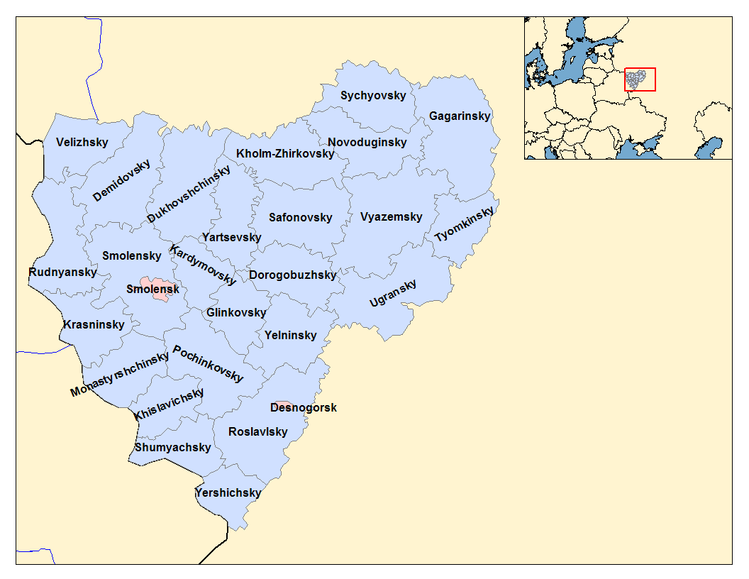
Smolensk Oblast (russian: ąĪą╝ąŠą╗ąĄ╠üąĮčüą║ą░čÅ ąŠ╠üą▒ą╗ą░čüčéčī, ''Smolenskaya oblast''; informal name ŌĆö ''Smolenschina'' (russian: ąĪą╝ąŠą╗ąĄ╠üąĮčēąĖąĮą░)) is a federal subject of Russia (an oblast). Its administrative centre is the city of Smolensk. As of the 2010 Census, its population was 985,537. Geography The oblast was founded on 27 September 1937.ąśčüą┐ąŠą╗ąĮąĖč鹥ą╗čīąĮčŗą╣ ą║ąŠą╝ąĖč鹥čé ąĪą╝ąŠą╗ąĄąĮčüą║ąŠą│ąŠ ąŠą▒ą╗ą░čüčéąĮąŠą│ąŠ čüąŠą▓ąĄčéą░ ąĮą░čĆąŠą┤ąĮčŗčģ ą┤ąĄą┐čāčéą░č鹊ą▓. ąōąŠčüčāą┤ą░čĆčüčéą▓ąĄąĮąĮčŗą╣ ą░čĆčģąĖą▓ ąĪą╝ąŠą╗ąĄąĮčüą║ąŠą╣ ąŠą▒ą╗ą░čüčéąĖ. "ąÉą┤ą╝ąĖąĮąĖčüčéčĆą░čéąĖą▓ąĮąŠ-č鹥čĆčĆąĖč鹊čĆąĖą░ą╗čīąĮąŠąĄ čāčüčéčĆąŠą╣čüčéą▓ąŠ ąĪą╝ąŠą╗ąĄąĮčüą║ąŠą╣ ąŠą▒ą╗ą░čüčéąĖ. ąĪą┐čĆą░ą▓ąŠčćąĮąĖą║", ąĖąĘą┤. "ą£ąŠčüą║ąŠą▓čüą║ąĖą╣ čĆą░ą▒ąŠčćąĖą╣", ą£ąŠčüą║ą▓ą░ 1981. ąĪčéčĆ. 8 It borders Pskov Oblast in the north, Tver Oblast in the northeast, Moscow Oblast in the east, Kaluga Oblast in south, Bryansk Oblast in the southwest, and Mogilev and Vitebsk Oblast ... [...More Info...] [...Related Items...] OR: [Wikipedia] [Google] [Baidu] |
Daugava
, be, ąŚą░čģąŠą┤ąĮčÅčÅ ąöąĘą▓č¢ąĮą░ (), liv, V─ōna, et, V├żina, german: D├╝na , image = Fluss-lv-D├╝na.png , image_caption = The drainage basin of the Daugava , source1_location = Valdai Hills, Russia , mouth_location = Gulf of Riga, Baltic Sea , mouth_coordinates = , subdivision_type1 = Country , subdivision_name1 = Belarus, Latvia, Russia , length = , source1_elevation = , mouth_elevation = , discharge1_avg = , basin_size = , pushpin_map = , pushpin_map_size = , pushpin_map_caption = , pushpin_map_alt = The Daugava ( ltg, Daugova; german: D├╝na) or Western Dvina (russian: ąŚą░ą┐ą░ą┤ąĮą░čÅ ąöą▓ąĖąĮą░, translit=Z├Īpadnaya Dvin├Ī; be, ąŚą░čģąŠą┤ąĮčÅčÅ ąöąĘą▓č¢ąĮą░; et, V├żina; fi, V├żin├żjoki) is a large river rising in the Valdai Hills of Russia that flows through Belarus and Latvia into the Gulf of Riga of the Baltic Sea. It rises close to the source of the Volga. It is in length, of which are in Latvia and are in Russia. It is a westward-flowing river, t ... [...More Info...] [...Related Items...] OR: [Wikipedia] [Google] [Baidu] |
Lakes Of Smolensk Oblast
A lake is an area filled with water, localized in a basin, surrounded by land, and distinct from any river or other outlet that serves to feed or drain the lake. Lakes lie on land and are not part of the ocean, although, like the much larger oceans, they do form part of the Earth's water cycle. Lakes are distinct from lagoons, which are generally coastal parts of the ocean. Lakes are typically larger and deeper than ponds, which also lie on land, though there are no official or scientific definitions. Lakes can be contrasted with rivers or streams, which usually flow in a channel on land. Most lakes are fed and drained by rivers and streams. Natural lakes are generally found in mountainous areas, rift zones, and areas with ongoing glaciation. Other lakes are found in endorheic basins or along the courses of mature rivers, where a river channel has widened into a basin. Some parts of the world have many lakes formed by the chaotic drainage patterns left over from the last ice ... [...More Info...] [...Related Items...] OR: [Wikipedia] [Google] [Baidu] |
Depth Sapsho-Petrakovskoye
Depth(s) may refer to: Science and mathematics * Three-dimensional space * Depth (ring theory), an important invariant of rings and modules in commutative and homological algebra * Depth in a well, the measurement between two points in an oil well * Color depth (or "number of bits" or "bit depth"), in computer graphics * Market depth, in financial markets, the size of an order needed to move the market a given amount * Moulded depth, a nautical measurement * Sequence depth, or coverage, in genetic sequencing * Depth (coordinate), a type of vertical distance * Tree depth Art and entertainment * ''Depth'' (video game), an Indie video game * ''Depths'' (novel), a 2004 novel by Henning Mankell * ''Depths'' (Oceano album), 2009 * ''Depths'' (Windy & Carl album), 1998 * "Depths" (''Law & Order: Criminal Intent''), an episode of ''Law & Order: Criminal Intent'' * ''Depth'', the Japanese title for the PlayStation game released in Europe under the name ''Fluid'' * Depth, an asym ... [...More Info...] [...Related Items...] OR: [Wikipedia] [Google] [Baidu] |
Western Dvina
, be, ąŚą░čģąŠą┤ąĮčÅčÅ ąöąĘą▓č¢ąĮą░ (), liv, V─ōna, et, V├żina, german: D├╝na , image = Fluss-lv-D├╝na.png , image_caption = The drainage basin of the Daugava , source1_location = Valdai Hills, Russia , mouth_location = Gulf of Riga, Baltic Sea , mouth_coordinates = , subdivision_type1 = Country , subdivision_name1 = Belarus, Latvia, Russia , length = , source1_elevation = , mouth_elevation = , discharge1_avg = , basin_size = , pushpin_map = , pushpin_map_size = , pushpin_map_caption = , pushpin_map_alt = The Daugava ( ltg, Daugova; german: D├╝na) or Western Dvina (russian: ąŚą░ą┐ą░ą┤ąĮą░čÅ ąöą▓ąĖąĮą░, translit=Z├Īpadnaya Dvin├Ī; be, ąŚą░čģąŠą┤ąĮčÅčÅ ąöąĘą▓č¢ąĮą░; et, V├żina; fi, V├żin├żjoki) is a large river rising in the Valdai Hills of Russia that flows through Belarus and Latvia into the Gulf of Riga of the Baltic Sea. It rises close to the source of the Volga. It is in length, of which are in Latvia and are in Russia. It is a westward-flowing river, tra ... [...More Info...] [...Related Items...] OR: [Wikipedia] [Google] [Baidu] |
SmolenskŌĆōMoscow Upland
The SmolenskŌĆōMoscow Upland is located in the Yaroslavl, Vladimir, Moscow and Smolensk regions of Russia, as well as the Vitebsk region of Belarus. Geography It stretches from southwest to northeast from the Belarusian city of Orsha to Yuriev-Polsky. It consists of the Smolensk Upland (western part) and the Moscow Uplands (eastern part). It extends 500 km. Its highest point is 320 m (northeastern part of Smolensk). The terrain is hilly, erosion-moraine. In the west the moraine chain goes to the Belarusian ridge . The Dnieper (west) and the Volga (east) rivers drain its hill. The watersheds feed three seas: the Baltic (Kasplya ŌåÆ Western Dvina), Black (Dnieper) and the Caspian (the Volga, the Oka River and their tributaries). Ecology It is covered with mixed forests, dominated by spruce and birch. Peat bogs are also present. Its soils are mainly sod-podzolic, loam Loam (in geology and soil science) is soil composed mostly of sand (particle size > ), silt (parti ... [...More Info...] [...Related Items...] OR: [Wikipedia] [Google] [Baidu] |
Sloboda Upland
A sloboda ( rus, čüą╗ąŠą▒ąŠą┤ą░╠ü, p=sl╔Öb╔É╦łda) was a kind of settlement in the history of the Old Russian regions Povolzhye, Central Russia, Belarus and Ukraine. The name is derived from the early Slavic word for "freedom" and may be loosely translated as "(tax-)free settlement"."Sloboda" '''' (1890ŌĆō1906) In modern Russia, the term is used to denote a type of a rural locality in |


