|
Lake Mweru
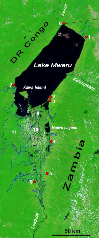
Lake Mweru (also spelled ''Mwelu'', ''Mwero'') is a freshwater lake on the longest arm of Africa's second-longest river, the Congo. Located on the border between Zambia and Democratic Republic of the Congo, it makes up of the total length of the Congo, lying between its Luapula River (upstream) and Luvua River (downstream) segments.Google Earth accessed 29 March 2007. When in flood Lake Bangweulu and its swamps may temporarily have a larger area, but not a larger volume. Mweru means 'lake' in a number of Bantu languages, so it is often referred to as just 'Mweru'.The ''Northern Rhodesia Journal'' online at NZRAM.org: J B W Anderson: "Kilwa Island and the Luapula." Vol II, No. 3 pp87–88 (1954) Physical geography Mweru is mainly fed by the Luapula River, which comes in through swamps from the south, and the Kalungwishi River from the east. At its north end the lake is drained by the Luvua River, which flows in a northwesterly direction to join the Lualaba River and thence to th ... [...More Info...] [...Related Items...] OR: [Wikipedia] [Google] [Baidu] |
Rift Valley Lakes
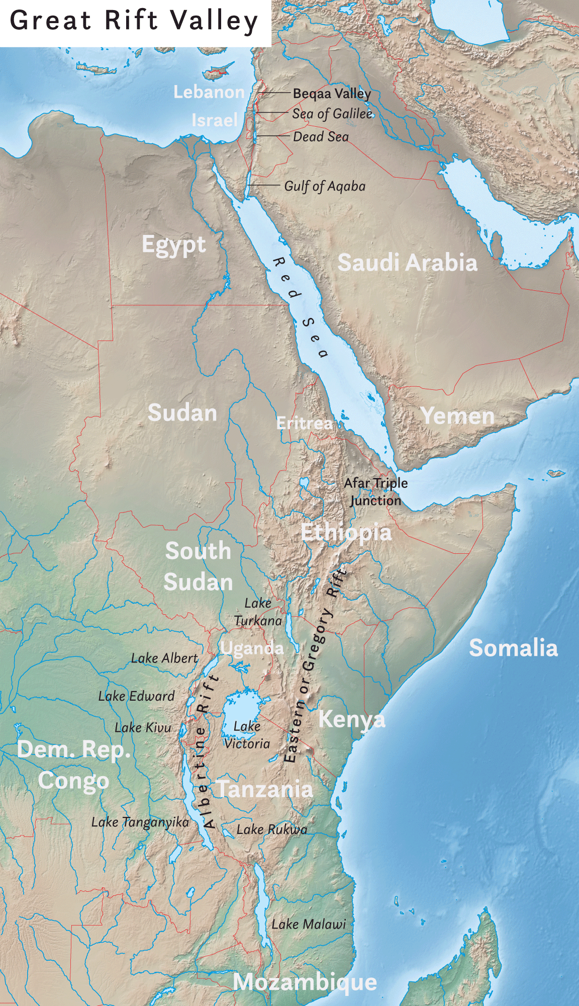
The Rift Valley lakes are a series of lakes in the East African Rift valley that runs through eastern Africa from Ethiopia in the north to Malawi in the south, and includes the African Great Lakes in the south. These include some of the world's oldest lakes, deepest lakes, largest lakes by area, and largest lakes by volume. Many are freshwater ecoregions of great biodiversity, while others are alkaline "soda lakes" supporting highly specialised organisms. The Rift Valley lakes are well known for the evolution of at least 800 cichlid fish species that live in their waters. More species are expected to be discovered. The World Wide Fund for Nature has designated these lakes as one of its Global 200 priority ecoregions for conservation. Geology Lake Malawi and Lake Tanganyika have formed in the various valleys of the East African Rift zone. Ecology Lake Kivu's "still waters ... hide another face: dissolved within are billions of cubic meters of flammable methane and more stil ... [...More Info...] [...Related Items...] OR: [Wikipedia] [Google] [Baidu] |
Congo River
The Congo River ( kg, Nzâdi Kôngo, french: Fleuve Congo, pt, Rio Congo), formerly also known as the Zaire River, is the second longest river in Africa, shorter only than the Nile, as well as the second largest river in the world by discharge volume, following only the Amazon. It is also the world's deepest recorded river, with measured depths around . The Congo- Lualaba- Chambeshi River system has an overall length of , which makes it the world's ninth- longest river. The Chambeshi is a tributary of the Lualaba River, and ''Lualaba'' is the name of the Congo River upstream of Boyoma Falls, extending for . Measured along with the Lualaba, the main tributary, the Congo River has a total length of . It is the only major river to cross the Equator twice. The Congo Basin has a total area of about , or 13% of the entire African landmass. Name The name ''Congo/Kongo'' originates from the Kingdom of Kongo once located on the southern bank of the river. The kingdom in turn was name ... [...More Info...] [...Related Items...] OR: [Wikipedia] [Google] [Baidu] |
Escarpment
An escarpment is a steep slope or long cliff that forms as a result of faulting or erosion and separates two relatively level areas having different elevations. The terms ''scarp'' and ''scarp face'' are often used interchangeably with ''escarpment''. Some sources differentiate the two terms, with ''escarpment'' referring to the margin between two landforms, and ''scarp'' referring to a cliff or a steep slope. In this usage an escarpment is a ridge which has a gentle slope on one side and a steep scarp on the other side. More loosely, the term ''scarp'' also describes a zone between a coastal lowland and a continental plateau which shows a marked, abrupt change in elevation caused by coastal erosion at the base of the plateau. Formation and description Scarps are generally formed by one of two processes: either by differential erosion of sedimentary rocks, or by movement of the Earth's crust at a geologic fault. The first process is the more common type: the escarpment is a t ... [...More Info...] [...Related Items...] OR: [Wikipedia] [Google] [Baidu] |
East African Rift
The East African Rift (EAR) or East African Rift System (EARS) is an active continental rift zone in East Africa. The EAR began developing around the onset of the Miocene, 22–25 million years ago. In the past it was considered to be part of a larger Great Rift Valley that extended north to Asia Minor. A narrow zone, the rift is a developing divergent tectonic plate boundary where the African Plate is in the process of splitting into two tectonic plates, called the Somali Plate and the Nubian Plate, at a rate of 6-7 mm per year. The rift system consists of three microplates, the Victoria Microplate to the north, and the Rovuma and Lwandle microplates to the south. The Victoria Microplate is rotating anti-clockwise with respect to the African plate. Its rotation is caused by the configuration of mechanically weaker and stronger lithospheric regions in the EARS. Extent A series of distinct rift basins, the East African Rift System extends over thousands of kilometers. The ... [...More Info...] [...Related Items...] OR: [Wikipedia] [Google] [Baidu] |
Graben
In geology, a graben () is a depressed block of the crust of a planet or moon, bordered by parallel normal faults. Etymology ''Graben'' is a loan word from German, meaning 'ditch' or 'trench'. The word was first used in the geologic context by Eduard Suess in 1883. The plural form is either ''graben'' or ''grabens''. Formation A graben is a valley with a distinct escarpment on each side caused by the displacement of a block of land downward. Graben often occur side by side with horsts. Horst and graben structures indicate tensional forces and crustal stretching. Graben are produced from parallel normal faults, where the displacement of the hanging wall is downward, while that of the footwall is upward. The faults typically dip toward the center of the graben from both sides. Horsts are parallel blocks that remain between graben; the bounding faults of a horst typically dip away from the center line of the horst. Single or multiple graben can produce a rift valley. Half-g ... [...More Info...] [...Related Items...] OR: [Wikipedia] [Google] [Baidu] |
Bangweulu Swamps
The Bangweulu Wetlands is a wetland ecosystem adjacent to Lake Bangweulu in north-eastern Zambia. The area has been designated as one of the world's most important wetlands by the Ramsar Convention and an "Important Bird Area" by BirdLife International. African Parks began managing Bangweulu in partnership with Zambia's Department of National Parks and Wildlife with the establishment of the Bangweulu Wetland Management Board in 2008. Overview The Bangweulu Wetlands ecosystem was first described in the 1940s. Bangweulu, which means "where the water sky meets the sky", is located mostly within Zambia's Northern Province and recognized by the Ramsar Convention as one of the world's most important wetlands. The region has floodplains, seasonally flooded grasslands, woodlands, and permanent swamps fed by the Chambeshi, Luapula, Lukulu, and Lulimala rivers. The nonprofit conservation organization African Parks manages a area of the greater Bangweulu ecosystem. Flora and fauna The ec ... [...More Info...] [...Related Items...] OR: [Wikipedia] [Google] [Baidu] |
River Delta
A river delta is a landform shaped like a triangle, created by deposition (geology), deposition of sediment that is carried by a river and enters slower-moving or stagnant water. This occurs where a river enters an ocean, sea, estuary, lake, reservoir, or (more rarely) another river that cannot carry away the supplied sediment. It is so named because its triangle shape resembles the Greek letter Delta. The size and shape of a delta is controlled by the balance between watershed processes that supply sediment, and receiving basin processes that redistribute, sequester, and export that sediment. The size, geometry, and location of the receiving basin also plays an important role in delta evolution. River deltas are important in human civilization, as they are major agricultural production centers and population centers. They can provide Coast, coastline defense and can impact drinking water supply. They are also Ecology, ecologically important, with different species' assemblages ... [...More Info...] [...Related Items...] OR: [Wikipedia] [Google] [Baidu] |
Lake Tanganyika
Lake Tanganyika () is an African Great Lake. It is the second-oldest freshwater lake in the world, the second-largest by volume, and the second-deepest, in all cases after Lake Baikal in Siberia. It is the world's longest freshwater lake. The lake is shared among four countries—Tanzania, the Democratic Republic of the Congo (DRC), Burundi, and Zambia, with Tanzania (46%) and DRC (40%) possessing the majority of the lake. It drains into the Congo River system and ultimately into the Atlantic Ocean. Etymology "Tanganika" was the name of the lake that Henry Morton Stanley encountered when he was at Ujiji in 1876. The name first originated from the Bembe language when they arrived in South Kivu around the 7th century, they discovered the lake and started calling it “êtanga ‘ya’ni’â” which means “a big river” in their Bantu language. Stanley found also other names for the lake among different ethnic groups, like the Kimana, the Yemba and the Msaga. An alt ... [...More Info...] [...Related Items...] OR: [Wikipedia] [Google] [Baidu] |
Drainage Basin
A drainage basin is an area of land where all flowing surface water converges to a single point, such as a river mouth, or flows into another body of water, such as a lake or ocean. A basin is separated from adjacent basins by a perimeter, the '' drainage divide'', made up of a succession of elevated features, such as ridges and hills. A basin may consist of smaller basins that merge at river confluences, forming a hierarchical pattern. Other terms for a drainage basin are catchment area, catchment basin, drainage area, river basin, water basin, and impluvium. In North America, they are commonly called a watershed, though in other English-speaking places, "watershed" is used only in its original sense, that of a drainage divide. In a closed drainage basin, or endorheic basin, the water converges to a single point inside the basin, known as a sink, which may be a permanent lake, a dry lake, or a point where surface water is lost underground. Drainage basins are similar ... [...More Info...] [...Related Items...] OR: [Wikipedia] [Google] [Baidu] |
Lualaba River
The Lualaba River flows entirely within the eastern Democratic Republic of the Congo. It provides the greatest streamflow to the Congo River, while the source of the Congo is recognized as the Chambeshi. The Lualaba is long. Its headwaters are in the country's far southeastern corner near Musofi and Lubumbashi in Katanga Province, next to the Zambian Copperbelt. Course The source of the Lualaba River is on the Katanga plateau, at an elevation of above sea level. The river flows northward to end near Kisangani, where the name Congo River officially begins. From the Katanga plateau it drops, with waterfalls and rapids marking the descent, to the Manika plateau. As it descends through the upper Upemba Depression (Kamalondo Trough), in . Near Nzilo Falls it is dammed for hydroelectric power at the Nzilo Dam. At Bukama in Haut-Lomami District the river becomes navigable for about through a series of marshy lakes in the lower Upemba Depression, including Lake Upemba and Lake Kisale ... [...More Info...] [...Related Items...] OR: [Wikipedia] [Google] [Baidu] |
Northern Rhodesia Journal
The ''Northern Rhodesia Journal'', often referred to simply as "NRJ", was produced between 1950 and 1965, by the Northern Rhodesian Government Printer, to record some of the early history of Northern Rhodesia. It is one of the most important sources of historical information on Zambia before and during its colonial era, up to its independence from the United Kingdom. Format The Journal is quarto in size. The first two volumes comprised six "Numbers" each, and the page numbering started with 1 for each Number. For the remaining four volumes (the first three of which also had six Numbers) the pages in each volume were numbered continuously, started with page 1 in Number 1 of each volume. The final volume (VI) had but three Numbers, the pages numbered continuously, started with page 1 in Number 1, and, as it was produced after Independence, was titled The ''Zambia Northern Rhodesia Journal''. Purpose From the "Editorial" of the first issue:- ''The difficulty is to state in a succi ... [...More Info...] [...Related Items...] OR: [Wikipedia] [Google] [Baidu] |
Bantu Languages
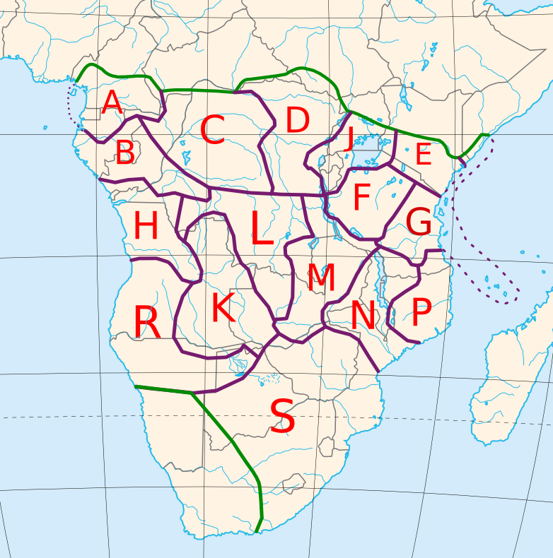
The Bantu languages (English: , Proto-Bantu: *bantʊ̀) are a large family of languages spoken by the Bantu people of Central, Southern, Eastern africa and Southeast Africa. They form the largest branch of the Southern Bantoid languages. The total number of Bantu languages ranges in the hundreds, depending on the definition of "language" versus "dialect", and is estimated at between 440 and 680 distinct languages."Guthrie (1967-71) names some 440 Bantu 'varieties', Grimes (2000) has 501 (minus a few 'extinct' or 'almost extinct'), Bastin ''et al.'' (1999) have 542, Maho (this volume) has some 660, and Mann ''et al.'' (1987) have ''c.'' 680." Derek Nurse, 2006, "Bantu Languages", in the ''Encyclopedia of Language and Linguistics'', p. 2:Ethnologue report for Southern Bantoid" lists a total of 535 languages. The count includes 13 Mbam languages, which are not always included under "Narrow Bantu". For Bantuic, Linguasphere has 260 outer languages (which are equivalent to languages ... [...More Info...] [...Related Items...] OR: [Wikipedia] [Google] [Baidu] |


