|
Lake Assad
Lake Assad ( ar, بحيرة الأسد, ''Buhayrat al-Assad'') is a reservoir on the Euphrates in Raqqa Governorate, Syria. It was created in 1974 when construction of the Tabqa Dam was completed. Lake Assad is Syria's largest lake, with a maximum capacity of and a maximum surface area of . A vast network of canals uses water from Lake Assad to irrigate lands on both sides of the Euphrates. In addition, the lake provides drinking water for the city of Aleppo and supports a fishing industry. The shores of Lake Assad have developed into important ecological zones. Project history The first plans for a dam in the Syrian part of the Euphrates date to 1927, but these were not carried out. In 1957, an agreement was reached with the Soviet Union for technical and financial aid for the construction of a dam in the Euphrates, and in 1960 a financial agreement was signed with West Germany. Another agreement to finance the project was signed with the Soviet Union in 1965. The project ... [...More Info...] [...Related Items...] OR: [Wikipedia] [Google] [Baidu] |
Tabqa Dam
The Tabqa Dam ( ar, سَدُّ الطَّبْقَةِ, Sadd aṭ-Ṭabqah, ku, Bendava Tebqa; syc, ܣܟܪܐ ܕܛܒܩܗ, Sekro d'Tabqa), or al-Thawra Dam as it is also named ( ar, سَدُّ الثَّوْرَةِ, Sadd aṯ-Ṯawrah, ku, Bendava Tewra; syc, ܣܟܪܐ ܕܬܘܪܗ, Sekro d'Ṯawra, literally "Dam of the Revolution"), most commonly known as Euphrates Dam ( ar, سَدُّ الْفُرَاتِ, Sadd al-Furāt; ku, Bendava Firatê; syc, ܣܟܪܐ ܕܦܪܬ, Sekro d'Frot), is an earthen dam on the Euphrates, located upstream from the city of Raqqa in Raqqa Governorate, Syria. The city of Al-Thawrah is located immediately south of the dam. The dam is high and long and is the largest dam in Syria. Its construction led to the creation of Lake Assad, Syria's largest water reservoir. The dam was constructed between 1968 and 1973 with help from the Soviet Union. At the same time, an international effort was made to excavate and document as many archaeological remains as ... [...More Info...] [...Related Items...] OR: [Wikipedia] [Google] [Baidu] |
Tell Abu Hureyra
Tell Abu Hureyra ( ar, تل أبو هريرة) is a prehistoric archaeological site in the Upper Euphrates valley in Syria. The tell was inhabited between 13,000 and 9,000 years ago in two main phases: Abu Hureyra 1, dated to the Epipalaeolithic, was a village of sedentary hunter-gatherers; Abu Hureyra 2, dated to the Pre-Pottery Neolithic, was home to some of the world's first farmers. This almost continuous sequence of occupation through the Neolithic Revolution has made Abu Hureyra one of the most important sites in the study of the origins of agriculture. The site is significant because the inhabitants of Abu Hureyra started out as hunter-gatherers but gradually moved to farming, making them the earliest known farmers in the world. Cultivation started at the beginning of the Younger Dryas period at Abu Hureyra. Evidence uncovered at Abu Hureyra suggests that rye was the first cereal crop to be systematically cultivated. In light of this, it is now believed that the fir ... [...More Info...] [...Related Items...] OR: [Wikipedia] [Google] [Baidu] |
Evergreen
In botany, an evergreen is a plant which has foliage that remains green and functional through more than one growing season. This also pertains to plants that retain their foliage only in warm climates, and contrasts with deciduous plants, which completely lose their foliage during the winter or dry season. Evergreen species There are many different kinds of evergreen plants, both trees and shrubs. Evergreens include: *Most species of conifers (e.g., pine, hemlock, blue spruce, and red cedar), but not all (e.g., larch) * Live oak, holly, and "ancient" gymnosperms such as cycads *Most angiosperms from frost-free climates, and rainforest trees *All Eucalypts * Clubmosses and relatives *Bamboos The Latin binomial term , meaning "always green", refers to the evergreen nature of the plant, for instance :'' Cupressus sempervirens'' (a cypress) :'' Lonicera sempervirens'' (a honeysuckle) :'' Sequoia sempervirens'' (a sequoia) Leaf longevity in evergreen plants varies from ... [...More Info...] [...Related Items...] OR: [Wikipedia] [Google] [Baidu] |
Bassin Tigre Euphrate
Bassin may refer to: People * Elieser Bassin (1840–1898), British Israelist * Mark Bassin, British geographer * Sherwood Bassin (born 1939), Canadian ice hockey executive Other uses * The Grand Bassin, the largest body of open water along the Canal du Midi See also * Basin (other) * Bassein (other) Bassein may refer to: vasai India * Vasai, a city in Maharashtra state, India; known as Bassein during Portuguese rule ** Treaty of Bassein (1534) ** Treaty of Bassein (1802) ** Military history of Bassein * Bassein Fort, a colonial fort in Vasai b ... * Bassins, Switzerland {{Disambiguation, surname ... [...More Info...] [...Related Items...] OR: [Wikipedia] [Google] [Baidu] |
Soil Salinity
Soil salinity is the salt content in the soil; the process of increasing the salt content is known as salinization. Salts occur naturally within soils and water. Salination can be caused by natural processes such as mineral weathering or by the gradual withdrawal of an ocean. It can also come about through artificial processes such as irrigation and road salt. Natural occurrence Salts are a natural component in soils and water. The ions responsible for salination are: Na+, K+, Ca2+, Mg2+ and Cl−. Over long periods of time, as soil minerals weather and release salts, these salts are flushed or leached out of the soil by drainage water in areas with sufficient precipitation. In addition to mineral weathering, salts are also deposited via dust and precipitation. Salts may accumulate in dry regions, leading to naturally saline soils. This is the case, for example, in large parts of Australia. Human practices can increase the salinity of soils by the addition of salts i ... [...More Info...] [...Related Items...] OR: [Wikipedia] [Google] [Baidu] |
Gypsum
Gypsum is a soft sulfate mineral composed of calcium sulfate dihydrate, with the chemical formula . It is widely mined and is used as a fertilizer and as the main constituent in many forms of plaster, blackboard or sidewalk chalk, and drywall. Alabaster, a fine-grained white or lightly tinted variety of gypsum, has been used for sculpture by many cultures including Ancient Egypt, Mesopotamia, Ancient Rome, the Byzantine Empire, and the Nottingham alabasters of Medieval England. Gypsum also crystallizes as translucent crystals of selenite. It forms as an evaporite mineral and as a hydration product of anhydrite. The Mohs scale of mineral hardness defines gypsum as hardness value 2 based on scratch hardness comparison. Etymology and history The word '' gypsum'' is derived from the Greek word (), "plaster". Because the quarries of the Montmartre district of Paris have long furnished burnt gypsum ( calcined gypsum) used for various purposes, this dehydrated gyp ... [...More Info...] [...Related Items...] OR: [Wikipedia] [Google] [Baidu] |
Meskene
Maskanah ( ar, مَسْكَنَة) also spelled, Meskene is a town in northern Syria, administratively part of the Manbij District of the Aleppo Governorate. The town is located southeast of Aleppo on the Lake Assad part of the Euphrates. Nearby localities include Dayr Hafir, Humaymah Kabirah and Tell Ayoub to the northwest and al-Thawrah to the southeast. According to the Syria Central Bureau of Statistics (CBS), Maskanah had a population of 15,477 in the 2004 census.General Census of Population and Housing 2004 Syria Central Bureau of Statistics (CBS). Aleppo Governorate. The Syrian gov ... [...More Info...] [...Related Items...] OR: [Wikipedia] [Google] [Baidu] |
Minaret
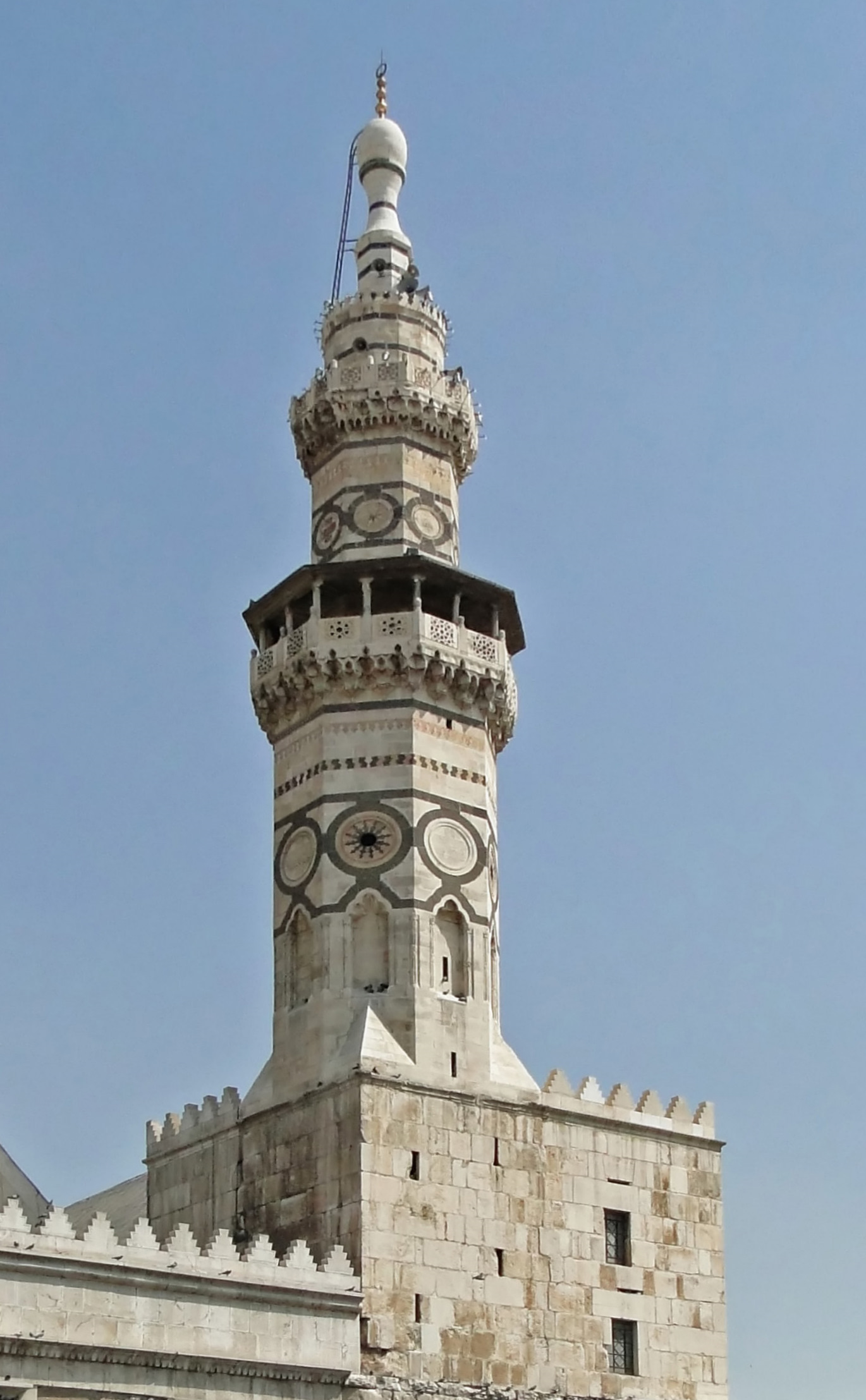
A minaret (; ar, منارة, translit=manāra, or ar, مِئْذَنة, translit=miʾḏana, links=no; tr, minare; fa, گلدسته, translit=goldaste) is a type of tower typically built into or adjacent to mosques. Minarets are generally used to project the Muslim call to prayer ('' adhan''), but they also served as landmarks and symbols of Islam's presence. They can have a variety of forms, from thick, squat towers to soaring, pencil-thin spires. Etymology Two Arabic words are used to denote the minaret tower: ''manāra'' and ''manār''. The English word "minaret" originates from the former, via the Turkish version (). The Arabic word ''manāra'' (plural: ''manārāt'') originally meant a "lamp stand", a cognate of Hebrew ''menorah''. It is assumed to be a derivation of an older reconstructed form, ''manwara''. The other word, ''manār'' (plural: ''manā'ir'' or ''manāyir''), means "a place of light". Both words derive from the Arabic root ''n-w-r'', which has a mea ... [...More Info...] [...Related Items...] OR: [Wikipedia] [Google] [Baidu] |
Qal'at Ja'bar
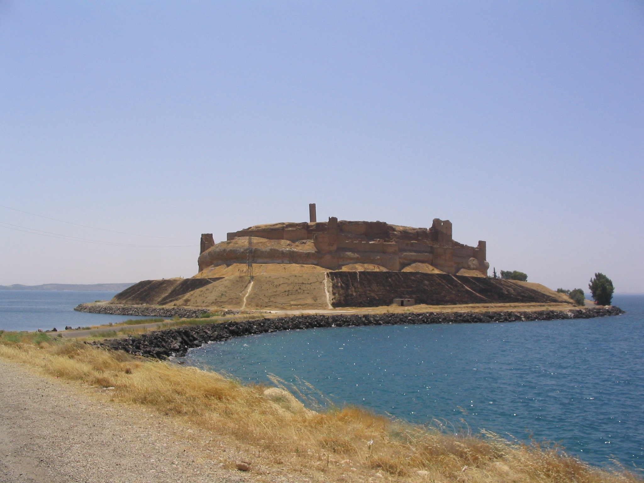
Qal'at Ja'bar ( ar, قلعة جعبر, tr, Caber Kalesi) is a castle on the left bank of Lake Assad in Raqqa Governorate, Syria. Its site, formerly a prominent hill-top overlooking the Euphrates Valley, is now an island in Lake Assad that can only be reached by an artificial causeway. Although the hilltop on which the castle sits was possibly already fortified in the 7th century, the current structures are primarily the work of Nur ad-Din, who rebuilt the castle from 1168 onwards. Since 1965, several excavations have been carried out in and around the castle, as well as restoration works of the walls and towers. The castle was a Turkish exclave between 1921 and 1973. History Before the castle It is not exactly known when the hilltop of Qal'at Ja'bar was first fortified. The site was already known as "Dawsar" in pre-Islamic times and was located along a route connecting Raqqa with the west. 11th century and later Qal'at Dawsar was mentioned in 1040/41 when the Fatimid gover ... [...More Info...] [...Related Items...] OR: [Wikipedia] [Google] [Baidu] |
Dibsi Faraj
Dibsi Faraj is an archaeological site on the right bank of the Euphrates in Aleppo Governorate (Syria). The site was excavated as part of a larger international effort coordinated by UNESCO to excavate as many archaeological sites as possible in the area that would be flooded by the reservoir created by the Tabqa Dam, which was being built at that time. An initial, small archaeological sounding was done at Dibsi Faraj by the Syrian Department of Antiquities in 1971. Following this investigation, the site was excavated between 1972 and 1974 as part of a joint operation of the Dumbarton Oaks, Dumbarton Oaks Center for Byzantine Studies and the Kelsey Museum of Archaeology at the University of Michigan under the direction of Richard P. Harper. Since then, the site has disappeared under the rising waters of Lake Assad, the reservoir created by the Tabqa Dam. The excavations revealed that the site was occupied between the first and tenth century CE. During this period, the site develop ... [...More Info...] [...Related Items...] OR: [Wikipedia] [Google] [Baidu] |
Tell Fray
Tell Fray is a Tell (archaeology), tell, or settlement mound, on the east bank of the Euphrates in Raqqa Governorate, northern Syria. The archaeological site takes its name from an ancient irrigation canal, hence 'Fray' or 'Little Euphrates'. Excavations It was excavated in 1972 and 1973 as a joint Syrian–Italian operation under the direction of Adnan Bounni of the Syrian Service of Archaeological Excavations and Paolo Matthiae, the excavator of Ebla. The operation was part of the UNESCO-coordinated international effort to excavate as many sites as possible in the area that would be flooded by the reservoir of the Tabqa Dam, which was being constructed at that time. Tell Fray disappeared under the rising waters of Lake Assad in 1974. The excavations revealed occupation layers dating to the 14th century BCE, or Bronze Age#Near East, Late Bronze Age. There were at least two temples in this city, one of them probably devoted to the god Teshub. A number of houses were also excav ... [...More Info...] [...Related Items...] OR: [Wikipedia] [Google] [Baidu] |
Sweyhat
Tell es-Sweyhat is the name of a large archaeological site on the Euphrates River in northern Syria. It is located in Raqqa Governorate roughly 95 km northeast of Aleppo and 60 km south of Carchemish. Also, a Uruk site of Jebel Aruda and a Bronze Age site Tell Hadidi (Azu) are located just across the river. History Sweyhat dates from 3100–1900 BC, or the Early Bronze Age and the very beginning of the Middle Bronze Age. The site covers approximately 45 hectares and consists of a central, high mound standing 15 meters above the surrounding plain and an extensive low mound surrounded by the remains of an earthen rampart. The site is located within Mesopotamia in a very marginal environment for agriculture, yet in antiquity it was a prosperous city. The site was also occupied during the Hellenistic Period. Archaeology Sweyhat is best known for its intact fortifications of the mid-to-late 3rd millennium BC and its late-3rd-millennium temple located at the summit of the ... [...More Info...] [...Related Items...] OR: [Wikipedia] [Google] [Baidu] |


