|
Labrador Current
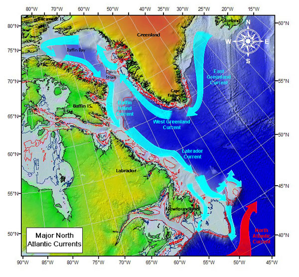
The Labrador Current is a cold current in the North Atlantic Ocean which flows from the Arctic Ocean south along the coast of Labrador and passes around Newfoundland, continuing south along the east coast of Canada near Nova Scotia. Near Nova Scotia, this cold water current meets the warm northward moving Gulf Stream. The combination of these two currents produces heavy fogs and has also created one of the richest fishing grounds in the world. In spring and early summer, the Labrador Current transports icebergs from the glaciers of Greenland southwards into the trans-Atlantic shipping lanes. The waters of the current have a cooling effect on the Canadian Atlantic provinces, and on the United States' upper northeast coast from Maine south to Massachusetts. South of Cape Cod, Massachusetts, the Gulf Stream becomes the dominant ocean current. Iceberg transport The Labrador Current has a tendency to sometimes go farther south and/or east than normal. This can produce hazardous sh ... [...More Info...] [...Related Items...] OR: [Wikipedia] [Google] [Baidu] |
Currents Of The Atlantic Ocean
Currents, Current or The Current may refer to: Science and technology * Current (fluid), the flow of a liquid or a gas ** Air current, a flow of air ** Ocean current, a current in the ocean *** Rip current, a kind of water current ** Current (stream), currents in rivers and streams ** Convection current, flow caused by unstable density variation due to temperature differences * Current (mathematics), geometrical current in differential topology * Conserved current, a field associated to a symmetry in field theory * Electric current, a flow of electric charge through a medium * Probability current, in quantum mechanics * IBM Current, an early personal information management program Arts and entertainment Music * ''Current'' (album), a 1982 album by Heatwave * ''Currents'' (Eisley album) * ''Currents'' (Tame Impala album) * "The Current" (song), by the Blue Man Group * "Currents", a song by Dashboard Confessional from ''Dusk and Summer'', 2006 * "Currents", a song by Drake from ... [...More Info...] [...Related Items...] OR: [Wikipedia] [Google] [Baidu] |
Currents Of The Arctic Ocean
Currents, Current or The Current may refer to: Science and technology * Current (fluid), the flow of a liquid or a gas ** Air current, a flow of air ** Ocean current, a current in the ocean *** Rip current, a kind of water current ** Current (stream), currents in rivers and streams ** Convection current, flow caused by unstable density variation due to temperature differences * Current (mathematics), geometrical current in differential topology * Conserved current, a field associated to a symmetry in field theory * Electric current, a flow of electric charge through a medium * Probability current, in quantum mechanics * IBM Current, an early personal information management program Arts and entertainment Music * ''Current'' (album), a 1982 album by Heatwave * ''Currents'' (Eisley album) * ''Currents'' (Tame Impala album) * "The Current" (song), by the Blue Man Group * "Currents", a song by Dashboard Confessional from ''Dusk and Summer'', 2006 * "Currents", a song by Drake from ... [...More Info...] [...Related Items...] OR: [Wikipedia] [Google] [Baidu] |
Flemish Cap
The Flemish Cap is an area of shallow waters in the north Atlantic Ocean centered roughly at 47° north, 45° west or about 563 km (350 miles) east of St. John's, Newfoundland and Labrador. The shallow water is caused by a wide underwater plateau covering an extended area of 42,000 km² (12,000 square miles). Depths at the cap range from approximately 122 m (400 feet) to 700 m (2,300 feet). The Flemish Cap is located within an area of transition between the cold waters of the Labrador Current and warmer waters influenced by the Gulf Stream. The mixing of the warmer and colder waters over the plateau produces the characteristic clockwise circulation current over the cap. The waters of the Flemish Cap are deeper and warmer than the Grand Banks of Newfoundland. The 58,000-square-kilometre area may have served as an important refuge for marine species during the last ice age. [...More Info...] [...Related Items...] OR: [Wikipedia] [Google] [Baidu] |
West Greenland Current
The West Greenland Current is a weak cold water current that flows to the north along the west coast of Greenland. The current results from the movement of water flowing around the southernmost point of Greenland caused by the East Greenland Current. According to Lloyd et al., 2007, the WGC is a WARM current connected to a broader scale North Atlantic climate via the combined influences of Atlantic water from the Irminger Current (IC) and polar water from the East Greenland Current. Paleoclimatology records derived from foraminifera abundance show that periodic influxes of warm subsurface temperatures and near-bottom temperatures occurred throughout the Late Holocene epoch, particularly during the Holocene climatic optimum. The increased flow from the nearby East Greenland Current was associated with increased glacial iceberg calving from the large Jakobshavn Isbrae glacial outlet within the western Greenland Ice Sheet, causing rapid melting and destabilization events. Follo ... [...More Info...] [...Related Items...] OR: [Wikipedia] [Google] [Baidu] |
Davis Strait
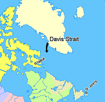
Davis Strait is a northern arm of the Atlantic Ocean that lies north of the Labrador Sea. It lies between mid-western Greenland and Baffin Island in Nunavut, Canada. To the north is Baffin Bay. The strait was named for the English explorer John Davis (1550–1605), who explored the area while seeking a Northwest Passage. By the 1650s it was used for whale hunting. Extent The International Hydrographic Organization defines the limits of the Davis Strait as follows: ''On the North.'' The Southern limit of Baffin Bay 70° North between Greenland and Baffin Island">Baffin Land]. ''On the East.'' The Southwest coast of Greenland. ''On the South.'' The parallel of 60th parallel north, 60° North between Greenland and Labrador. ''On the West.'' The Eastern limit of the Northwestern Passages South of 70° North he East coast of Baffin Island to East Bluff, its Southeastern extremityand of Hudson Strait line from East Bluff, the Southeast extreme of Baffin Island (), to Point ... [...More Info...] [...Related Items...] OR: [Wikipedia] [Google] [Baidu] |
Hudson Strait
Hudson Strait (french: Détroit d'Hudson) links the Atlantic Ocean and Labrador Sea to Hudson Bay in Canada. This strait lies between Baffin Island and Nunavik, with its eastern entrance marked by Cape Chidley in Newfoundland and Labrador and Resolution Island off Baffin Island. The strait is about 750 km long with an average width of 125 km, varying from 70 km at the eastern entrance to 240 km at Deception Bay. English navigator Sir Martin Frobisher was the first European to report entering the strait, in 1578. He named a tidal rip at the entrance the Furious Overfall and called the strait ''Mistaken Strait'', since he felt it held less promise as an entrance to the Northwest Passage than the body of water that was later named Frobisher Bay. John Davis sailed by the entrance to the strait during his voyage of 1587. The first European to explore the strait was George Weymouth who sailed 300 nautical miles beyond the Furious Overfall in 1602. The strait was ... [...More Info...] [...Related Items...] OR: [Wikipedia] [Google] [Baidu] |
Baffin Bay
Baffin Bay ( Inuktitut: ''Saknirutiak Imanga''; kl, Avannaata Imaa; french: Baie de Baffin), located between Baffin Island and the west coast of Greenland, is defined by the International Hydrographic Organization as a marginal sea of the Arctic Ocean. It is sometimes considered a sea of the North Atlantic Ocean. It is connected to the Atlantic via Davis Strait and the Labrador Sea. The narrower Nares Strait connects Baffin Bay with the Arctic Ocean. The bay is not navigable most of the year because of the ice cover and high density of floating ice and icebergs in the open areas. However, a polynya of about , known as the North Water, opens in summer on the north near Smith Sound. Most of the aquatic life of the bay is concentrated near that region. Extent The International Hydrographic Organization defines the limits of Baffin Bay as follows: History The area of the bay has been inhabited since BC. Around AD 1200, the initial Dorset settlers were replaced by ... [...More Info...] [...Related Items...] OR: [Wikipedia] [Google] [Baidu] |
North Atlantic Current
The North Atlantic Current (NAC), also known as North Atlantic Drift and North Atlantic Sea Movement, is a powerful warm western boundary current within the Atlantic Ocean that extends the Gulf Stream northeastward. The NAC originates from where the Gulf Stream turns north at the Southeast Newfoundland Rise, a submarine ridge that stretches southeast from the Grand Banks of Newfoundland. The NAC flows northward east of the Grand Banks, from 40°N to 51°N, before turning sharply east to cross the Atlantic. It transports more warm tropical water to northern latitudes than any other boundary current; more than 40 Sv () in the south and 20 Sv () as it crosses the Mid-Atlantic Ridge. It reaches speeds of near the North American coast. Directed by topography, the NAC meanders heavily, but in contrast to the meanders of the Gulf Stream, the NAC meanders remain stable without breaking off into eddies. The colder parts of the Gulf Stream turn northward near the "tail" of ... [...More Info...] [...Related Items...] OR: [Wikipedia] [Google] [Baidu] |
Labrador Sea
The Labrador Sea (French: ''mer du Labrador'', Danish: ''Labradorhavet'') is an arm of the North Atlantic Ocean between the Labrador Peninsula and Greenland. The sea is flanked by continental shelf, continental shelves to the southwest, northwest, and northeast. It connects to the north with Baffin Bay through the Davis Strait. It is a marginal sea of the Atlantic. The sea formed upon separation of the North American Plate and Greenland Plate that started about 60 million years ago and stopped about 40 million years ago. It contains one of the world's largest turbidity current channel systems, the Northwest Atlantic Mid-Ocean Channel (NAMOC), that runs for thousands of kilometers along the sea bottom toward the Atlantic Ocean. The Labrador Sea is a major source of the North Atlantic Deep Water, a cold water mass that flows at great depth along the western edge of the North Atlantic, spreading out to form the largest identifiable water mass in the World Ocean. History The Labrad ... [...More Info...] [...Related Items...] OR: [Wikipedia] [Google] [Baidu] |
International Ice Patrol
The International Ice Patrol is an organization with the purpose of monitoring the presence of icebergs in the Atlantic and Arctic Oceans and reporting their movements for safety purposes. It is operated by United States Coast Guard but is funded by the 13 nations interested in trans-Atlantic navigation. As of 2011 the governments contributing to the International Ice Patrol include Belgium, Canada (see Canadian Ice Service), Denmark, Finland, France, Germany, Greece, Italy, Japan, the Netherlands, Norway, Panama, Poland, Spain, Sweden, the United Kingdom, and the United States. The organization was established in 1914 in response to the sinking of RMS ''Titanic''. The primary mission of the Ice Patrol is to monitor the iceberg danger in the North Atlantic Ocean and provide relevant iceberg warning products to the maritime community. History Founding From the earliest journeys into the North Atlantic, icebergs have threatened vessels. A review of the history of navigation pr ... [...More Info...] [...Related Items...] OR: [Wikipedia] [Google] [Baidu] |


