|
Lovejoy Bridge
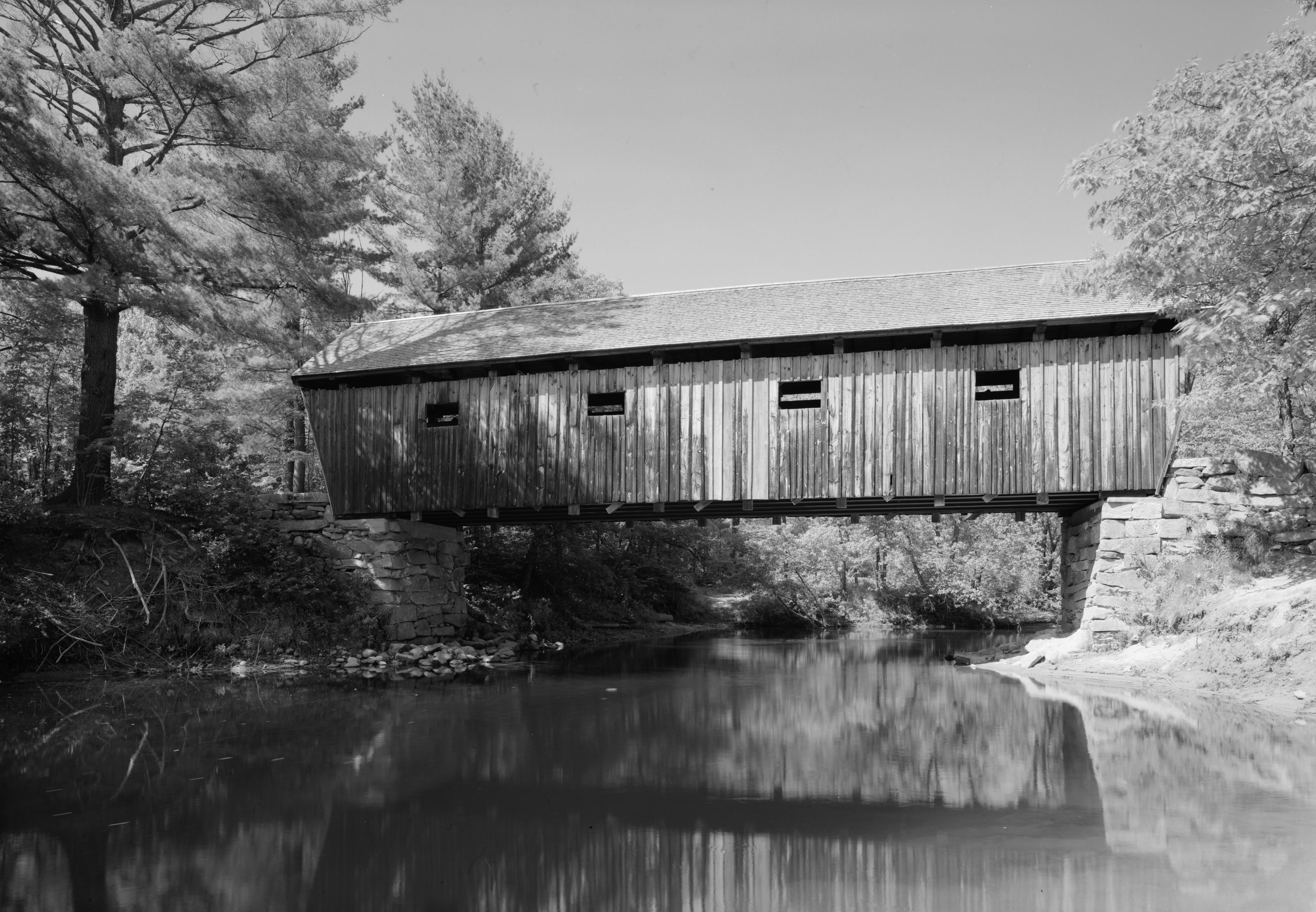
The Lovejoy Bridge is a historic covered bridge in South Andover, Maine. It is a Peter Paddleford, Paddleford truss bridge, which carries Covered Bridge Road over the Ellis River (Maine), Ellis River, about north of United States Route 2, US Route 2. Built in 1868, it is one of a small number of 19th-century covered bridges remaining in the state, and it is the state's shortest covered bridge. It was listed on the National Register of Historic Places in 1970. Description The Ellis River (Maine), Ellis River cuts a meandering course through the town of Andover, joining the Androscoggin River at Rumford, Maine, Rumford Point. There has probably been a bridge at this site in southern Andover since the early 19th century, as the river course narrows sufficiently, and provides a crossing point for people traveling between Rumford Point and the main village of Andover, which is located further north. This bridge was built in 1868, but it is known that a small village already existed near ... [...More Info...] [...Related Items...] OR: [Wikipedia] [Google] [Baidu] |
Ellis River (Maine)
The Ellis River is a U.S. Geological Survey. National Hydrography Dataset high-resolution flowline dataThe National Map , accessed June 30, 2011 river in Oxford County, Maine, Oxford County in western Maine. It is a tributary of the Androscoggin River. The river begins at the outlet of Ellis Pond in the northwest corner of Roxbury, Maine, Roxbury and flows southwest via a meandering course into Andover, Maine, Andover, passing the village of East Andover before turning more to the southeast near South Andover. The river enters the corporate limits of Rumford, Maine, Rumford and joins the Androscoggin at the village of Rumford Point. From South Andover to the river's mouth, the Ellis River is followed by Maine State Route 5. U.S. Route 2 crosses the river just above its outlet to the Androscoggin. References * Tributaries of the Kennebec River Rivers of Maine Rivers of Oxford County, Maine {{Maine-river-stub ... [...More Info...] [...Related Items...] OR: [Wikipedia] [Google] [Baidu] |
List Of Bridges On The National Register Of Historic Places In Maine
This is a list of bridges and tunnels on the National Register of Historic Places in the U.S. state of Maine. Bridges removed from the register References {{NRHP bridges Bridges on the National Register of Historic Places in Maine, Lists of bridges on the National Register of Historic Places by state, Maine Maine transportation-related lists, Bridges Lists of buildings and structures in Maine, Bridges ... [...More Info...] [...Related Items...] OR: [Wikipedia] [Google] [Baidu] |
Road Bridges On The National Register Of Historic Places In Maine
A road is a linear way for the conveyance of traffic that mostly has an road surface, improved surface for use by vehicles (motorized and non-motorized) and pedestrians. Unlike streets, the main function of roads is transportation. There are road hierarchy, many types of roads, including parkways, avenue (landscape), avenues, controlled-access highways (freeways, motorways, and expressways), tollways, interstates, highways, thoroughfares, and local roads. The primary features of roads include lanes, sidewalks (pavement), roadways (carriageways), median strip, medians, shoulder (road), shoulders, road verge, verges, bike paths (cycle paths), and shared-use paths. Definitions Historically many roads were simply recognizable routes without any formal construction or some maintenance. The Organisation for Economic Co-operation and Development, Organization for Economic Co-operation and Development (OECD) defines a road as "a line of communication (travelled way) using a stabiliz ... [...More Info...] [...Related Items...] OR: [Wikipedia] [Google] [Baidu] |
National Register Of Historic Places In Oxford County, Maine
This is a list of the National Register of Historic Places listings in Oxford County, Maine. This is intended to be a complete list of the properties and districts on the National Register of Historic Places in Oxford County, Maine, United States. Latitude and longitude coordinates are provided for many National Register properties and districts; these locations may be seen together in a map. There are 100 properties and districts listed on the National Register in the county. One property was once listed, but as since been delisted. Current listings Former listing See also * List of National Historic Landmarks in Maine * National Register of Historic Places listings in Maine References {{Oxford County, Maine Oxford Oxford () is a city in England. It is the county town and only city of Oxfordshire. In 2020, its population was estimated at 151,584. It i ... [...More Info...] [...Related Items...] OR: [Wikipedia] [Google] [Baidu] |
Historic American Engineering Record In Maine
History (derived ) is the systematic study and the documentation of the human activity. The time period of event before the invention of writing systems is considered prehistory. "History" is an umbrella term comprising past events as well as the memory, discovery, collection, organization, presentation, and interpretation of these events. Historians seek knowledge of the past using historical sources such as written documents, oral accounts, art and material artifacts, and ecological markers. History is not complete and still has debatable mysteries. History is also an academic discipline which uses narrative to describe, examine, question, and analyze past events, and investigate their patterns of cause and effect. Historians often debate which narrative best explains an event, as well as the significance of different causes and effects. Historians also debate the nature of history as an end in itself, as well as its usefulness to give perspective on the problems of the p ... [...More Info...] [...Related Items...] OR: [Wikipedia] [Google] [Baidu] |
Bridges In Oxford County, Maine
A bridge is a structure built to span a physical obstacle (such as a body of water, valley, road, or rail) without blocking the way underneath. It is constructed for the purpose of providing passage over the obstacle, which is usually something that is otherwise difficult or impossible to cross. There are many different designs of bridges, each serving a particular purpose and applicable to different situations. Designs of bridges vary depending on factors such as the function of the bridge, the nature of the terrain where the bridge is constructed and anchored, and the material used to make it, and the funds available to build it. The earliest bridges were likely made with fallen trees and stepping stones. The Neolithic people built boardwalk bridges across marshland. The Arkadiko Bridge (dating from the 13th century BC, in the Peloponnese) is one of the oldest arch bridges still in existence and use. Etymology The '' Oxford English Dictionary'' traces the origin of ... [...More Info...] [...Related Items...] OR: [Wikipedia] [Google] [Baidu] |
Bridges Completed In 1868
A bridge is a structure built to span a physical obstacle (such as a body of water, valley, road, or rail) without blocking the way underneath. It is constructed for the purpose of providing passage over the obstacle, which is usually something that is otherwise difficult or impossible to cross. There are many different designs of bridges, each serving a particular purpose and applicable to different situations. Designs of bridges vary depending on factors such as the function of the bridge, the nature of the terrain where the bridge is constructed and anchored, and the material used to make it, and the funds available to build it. The earliest bridges were likely made with fallen trees and stepping stones. The Neolithic people built boardwalk bridges across marshland. The Arkadiko Bridge (dating from the 13th century BC, in the Peloponnese) is one of the oldest arch bridges still in existence and use. Etymology The ''Oxford English Dictionary'' traces the origin of the ... [...More Info...] [...Related Items...] OR: [Wikipedia] [Google] [Baidu] |
Covered Bridges On The National Register Of Historic Places In Maine
Cover or covers may refer to: Packaging * Another name for a lid * Cover (philately), generic term for envelope or package * Album cover, the front of the packaging * Book cover or magazine cover ** Book design ** Back cover copy, part of copywriting * CD and DVD cover, CD and DVD packaging * Smartphone cover, a mobile phone accessory that protects a mobile phone People * Cover (surname) Arts, entertainment, and media Music Albums ;Cover * ''Cover'' (Tom Verlaine album), 1984 * ''Cover'' (Joan as Policewoman album), 2009 ;Covered * ''Covered'' (Cold Chisel album), 2011 * ''Covered'' (Macy Gray album), 2012 * ''Covered'' (Robert Glasper album), 2015 ;Covers * ''Covers'' (Beni album), 2012 * ''Covers'' (Regine Velasquez album), 2004 * ''Covers'' (Placebo album), 2003 * ''Covers'' (Show of Hands album), 2000 * ''Covers'' (James Taylor album), 2008 * ''Covers'' (Fayray album), 2005 * ''Covers'' (Deftones album), 2011 * ''Covers'' (Cat Power album), 2022 * ' ... [...More Info...] [...Related Items...] OR: [Wikipedia] [Google] [Baidu] |
List Of Maine Covered Bridges
This is a partial list of wooden covered bridges in the U.S. state of Maine. Bridges Extant Former See also *List of bridges on the National Register of Historic Places in Maine *World Guide to Covered Bridges References * * External links National Society for the Preservation of Covered Bridges article about the state's covered bridges {{Covered bridges in the United States, state=collapsed Covered bridges in Maine, Lists of covered bridges in the United States, Maine Maine transportation-related lists, covered bridges Lists of buildings and structures in Maine, Bridges, covered ... [...More Info...] [...Related Items...] OR: [Wikipedia] [Google] [Baidu] |
List Of Bridges Documented By The Historic American Engineering Record In Maine
__NOTOC__ This is a list of bridges documented by the Historic American Engineering Record in the U.S. state of Maine. Bridges References {{HAER list, structure=bridge *List *List Maine Maine () is a state in the New England and Northeastern regions of the United States. It borders New Hampshire to the west, the Gulf of Maine to the southeast, and the Canadian provinces of New Brunswick and Quebec to the northeast and north ... Bridges, HAER Bridges, HAER ... [...More Info...] [...Related Items...] OR: [Wikipedia] [Google] [Baidu] |
South Andover, Maine
South is one of the cardinal directions or compass points. The direction is the opposite of north and is perpendicular to both east and west. Etymology The word ''south'' comes from Old English ''sūþ'', from earlier Proto-Germanic ''*sunþaz'' ("south"), possibly related to the same Proto-Indo-European root that the word ''sun'' derived from. Some languages describe south in the same way, from the fact that it is the direction of the sun at noon (in the Northern Hemisphere), like Latin meridies 'noon, south' (from medius 'middle' + dies 'day', cf English meridional), while others describe south as the right-hand side of the rising sun, like Biblical Hebrew תֵּימָן teiman 'south' from יָמִין yamin 'right', Aramaic תַּימנַא taymna from יָמִין yamin 'right' and Syriac ܬܰܝܡܢܳܐ taymna from ܝܰܡܝܺܢܳܐ yamina (hence the name of Yemen, the land to the south/right of the Levant). Navigation By convention, the ''bottom or down-facing sid ... [...More Info...] [...Related Items...] OR: [Wikipedia] [Google] [Baidu] |
National Register Of Historic Places Listings In Oxford County, Maine
This is a list of the National Register of Historic Places listings in Oxford County, Maine. This is intended to be a complete list of the properties and districts on the National Register of Historic Places in Oxford County, Maine, United States. Latitude and longitude coordinates are provided for many National Register properties and districts; these locations may be seen together in a map. There are 100 properties and districts listed on the National Register in the county. One property was once listed, but as since been delisted. Current listings Former listing See also * List of National Historic Landmarks in Maine * National Register of Historic Places listings in Maine References {{Oxford County, Maine Oxford Oxford () is a city in England. It is the county town and only city of Oxfordshire. In 2020, its population was estimated at 151,584. It i ... [...More Info...] [...Related Items...] OR: [Wikipedia] [Google] [Baidu] |


.jpg)
