|
List Of Spa Towns In Greece ...
The following is a list of spa towns in Greece. * Aidipsos, Euboea * Agkistro, Serres * Kaiafa *Kamena Vourla * Kimolos * Krinides, Kavala *Lakkos of Milos island *Loutraki *Loutra Lagkadas * Loutra Kyllinis *Loutra, Kythnos island *Loutra, Nisyros island * Loutra Ypatis * Loutrochori, Aridaia, Pella (Pozar) *Methana *Nea Apollonia *Platistomo of Makrakomi *Polichnito of Lesbos island * Sidirokastro, Serres *Smokovo *Therma, Ikaria island *Thermopylae * Thermi, Thessaloniki See also * List of spa towns {{Europe in topic, List of spa towns in , countries_only=yes, UK_only=yes Towns (spa) Greece Greece,, or , romanized: ', officially the Hellenic Republic, is a country in Southeast Europe. It is situated on the southern tip of the Balkans, and is located at the crossroads of Europe, Asia, and Africa. Greece shares land borders ... [...More Info...] [...Related Items...] OR: [Wikipedia] [Google] [Baidu] |
Spa Town
A spa town is a resort town based on a mineral spa (a developed mineral spring). Patrons visit spas to "take the waters" for their purported health benefits. Thomas Guidott set up a medical practice in the English town of Bath in 1668. He became interested in the curative properties of the hot mineral waters there and in 1676 wrote ''A discourse of Bathe, and the hot waters there. Also, Some Enquiries into the Nature of the water''. This brought the purported health-giving properties of the waters to the attention of the aristocracy, who started to partake in them soon after. The term ''spa'' is used for towns or resorts offering hydrotherapy, which can include cold water or mineral water treatments and geothermal baths. Argentina *Termas de Rio Hondo *Presidencia Roque Sáenz Peña Australia There are mineral springs in the Central Highlands of Victoria. Most are in and around Daylesford and Hepburn Springs. Daylesford and Hepburn Springs call themselves 'Spa Countr ... [...More Info...] [...Related Items...] OR: [Wikipedia] [Google] [Baidu] |
Loutrochori, Pella
Loutrochori(on) ( el, Λουτροχώρι(οv) meaning "bath town"; formerly ''Paina'', Πάινα and ''Bania'', Μπάνια meaning "baths") is a village in the Pella regional unit, of Macedonia in Greece. According to the 2011 census, it has a population of 458, its area is 7.506 km2, and its population density is 62.08 per km2. The village is on a hill and thus it has a view of the surrounding countryside. Loutrochori is situated north of the Egnatia Highway (or A2, the Greek part of the E90) and south of the EO2 (or E 86). The nearest railroad (train) stations, on the OSE's Thessaloniki–Bitola railway, are east (Petrea), southeast ( Episkopi) and northeast (Skydra). The Loutrochori area was famous from ancient times for its spa. The spa (''iamatica loutra'', ιαματικά λουτρά) of Loutrochori (spa-drinking therapy) [...More Info...] [...Related Items...] OR: [Wikipedia] [Google] [Baidu] |
Spa Towns In Greece
A spa is a location where mineral-rich spring water (and sometimes seawater) is used to give medicinal baths. Spa towns or spa resorts (including hot springs resorts) typically offer various health treatments, which are also known as balneotherapy. The belief in the curative powers of mineral waters goes back to prehistoric times. Such practices have been popular worldwide, but are especially widespread in Europe and Japan. Day spas and medspas are also quite popular, and offer various personal care treatments. Origins of the term The term is derived from the name of the town of Spa, Belgium, whose name is known from Roman times, when the location was called ''Aquae Spadanae'', sometimes incorrectly connected to the Latin word ''spargere'' meaning to scatter, sprinkle or moisten. Since medieval times, illnesses caused by iron deficiency were treated by drinking chalybeate (iron-bearing) spring water (in 1326, the iron-master Collin le Loup claimed a cure,Medical Hydrology, S ... [...More Info...] [...Related Items...] OR: [Wikipedia] [Google] [Baidu] |
List Of Spa Towns
The list of spa towns lists national lists and various relevant spa towns around the world. In Africa Morocco * Moulay Yacoub Ethiopia *Afar Region * Guder *Sodere *Ambo South Africa * Caledon * Tshipise * Badplaas * Bela Bela In the Americas Argentina *Termas de Río Hondo, Santiago del Estero Province Brazil *Águas da Prata (São Paulo) * Águas de Chapecó (Santa Catarina) * Águas de Lindoia (São Paulo) *Águas de Santa Bárbara (São Paulo) *Águas de São Pedro (São Paulo) *Águas Mornas (Santa Catarina) *Araxá (Minas Gerais) * Caldas da Imperatriz (Santa Catarina) *Caldas Novas (Goiás) *Caxambu (Minas Gerais) *Piratuba (Santa Catarina) *Poços de Caldas (Minas Gerais) * São Lourenço (Minas Gerais) * Socorro (São Paulo) Cuba *Arriete-Ciego Montero Ecuador *Baños de Agua Santa, Tungurahua Province El Salvador * Agua Caliente Canada Alberta *Banff Upper Hot Springs *Miette Hot Springs British Columbia *Harrison Hot Springs *Radium Hot Springs * Fairmont H ... [...More Info...] [...Related Items...] OR: [Wikipedia] [Google] [Baidu] |
Thermi
Thermi ( el, Θέρμη) is a Southeastern suburb and a municipality in the Thessaloniki regional unit, Greece. Its population was 53,201 at the 2011 census. It is located over the site of ancient Therma. Municipality The municipality Thermi was formed at the 2011 local government reform by the merger of the following 3 former municipalities, that became municipal units: * Mikra *Thermi * Vasilika The municipality Thermi has an area of 382.106 km2, the municipal unit Thermi has an area of 100.943 km2, and the community Thermi has an area of 55.90 km2. Education Pinewood - The American International School is located in Thermi. . |
Thermopylae
Thermopylae (; Ancient Greek and Katharevousa: (''Thermopylai'') , Demotic Greek (Greek): , (''Thermopyles'') ; "hot gates") is a place in Greece where a narrow coastal passage existed in antiquity. It derives its name from its hot sulphur springs."Thermopylae" in: S. Hornblower & A. Spawforth (eds.) ''The Oxford Classical Dictionary'', 3rd ed. (Oxford, 1996). In Greek mythology the Hot Gates is one of the entrances to Hades. Thermopylae is the site of a battle between the Greek forces (including Spartans, Thebans and Thespians) and the invading Persian forces, commemorated by Simonides of Ceos in the epitaph, "Go tell the Spartans, stranger passing by, That here obedient to their laws we lie." Thermopylae is the only land route large enough to bear any significant traffic between Lokris and Thessaly. To go from north to south along the east coast of the Balkans requires use of the pass. In ancient times it was called Malis, named after the Malians ( grc, Μαλιεῖς), ... [...More Info...] [...Related Items...] OR: [Wikipedia] [Google] [Baidu] |
Icaria
Icaria, also spelled Ikaria ( el, Ικαρία), is a Greek island in the Aegean Sea, 10 nautical miles (19 km) southwest of Samos. According to tradition, it derives its name from Icarus, the son of Daedalus in Greek mythology, who was believed to have fallen into the sea nearby. Administratively, Icaria forms a separate municipality within the Ikaria regional unit, which is part of the North Aegean region. The principal town of the island and seat of the municipality is Agios Kirykos. The historic capitals of the island include Oenoe and Evdilos. Geography Icaria is one of the middle islands of the northern Aegean, in area with of coastline and a population of 8,312 inhabitants. The topography is a contrast between verdant slopes and barren steep rocks. The island is mountainous for the most part. It is traversed by the Aetheras range, whose highest summit is . Most of its villages are nestled in the plains near the coast, with some in the mountains. Icaria has a ... [...More Info...] [...Related Items...] OR: [Wikipedia] [Google] [Baidu] |
Therma, Icaria
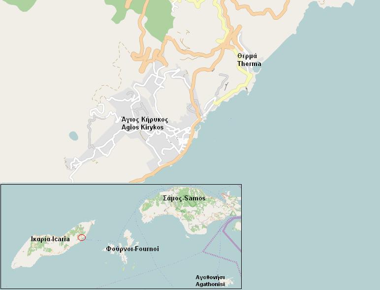
Therma ( el, Θέρμα) is a spa town on the island of Icaria in Greece. According to a study conducted by the University of Thessaloniki, the saline hot mineral springs of Icaria contain the largest concentration of radon in Greece, being also among the most radioactive springs in the world. The three springs currently in operation in the spa town of Therma (located 3 km East of Agios Kirykos Agios Kirykos ( el, Άγιος Κήρυκος) is a town and a former municipality on the island of Ikaria, North Aegean, Greece. Since the 2011 local government reform it is part of the municipality Ikaria, of which it is a municipal unit. Its pop ... port and 12 km from the island's airport) have a water temperature ranging between 45 and 52.8 degrees celsius (113–127 Fahrenheit). The radioactivity of the water covers a spectrum from 65 to 557 Mache units. The hot springs are available to visitors from May to November. References {{Coord, 37.624, 26.305, display=title ... [...More Info...] [...Related Items...] OR: [Wikipedia] [Google] [Baidu] |
Sidirokastro
Sidirokastro ( el, Σιδηρόκαστρο; Bulgarian and Macedonian: ''Valovišta''; tr, Demirhisar) is a town and a former municipality in the Serres regional unit, Greece. Since the 2011 local government reform it is part of the municipality Sintiki, of which it is the seat and a municipal unit. It is built near the fertile valley of the Struma River, river Strymonas, on the bank of the Krousovitis River. Sidirokastro is situated on the European route E79 and the main road from northern Greece (Thessaloniki) to Bulgaria. It has a number of tourist sights, such as the medieval stone castle, Byzantine ruins, and natural spas. General information Sidirokastro is located 25 km to the northwest of the town of Serres, between the Vrontous and Angistro mountains (to the north) and the river Struma (river), Strymonas (to the west). The 2011 census recorded 9,294 residents in the municipal unit of Sidirokastro, while there were 5,693 residents recorded in the community of ... [...More Info...] [...Related Items...] OR: [Wikipedia] [Google] [Baidu] |
Makrakomi
Makrakomi ( el, Μακρακώμη) is a town and a municipality in the western part of the Phthiotis regional unit, in Greece. The seat of the municipality is the town Spercheiada. Geography Makrakomi is built on the southern slopes of Western Othrys at an altitude of 280 m. It overlooks the river Spercheios and its valley. Makrakomi is located east of Karpenisi, ENE of Agrinio, south of Karditsa, west of Lamia and the GR-1/ E65 and the E75 as well as the GR-3 and WNW of Amfissa. Makrakomi is linked with the GR-38 (Agrinio - Evrytania - Lamia). Municipality The Municipality of Makrakomi was formed at the 2011 local government reform by the merger of the following 4 former municipalities, that became municipal units (constituent communities in brackets): *Agios Georgios Tymfristou (Agios Georgios, Dikastro, Mavrilo, Megali Kapsi, Merkada, Mesaia Kapsi, Neochori, Palaiokastro, Perivlepto, Pitsiota, Ptelea, Vitoli) *Makrakomi (Archani, Asvesti, Giannitsou, Grammeni, Kastri, L ... [...More Info...] [...Related Items...] OR: [Wikipedia] [Google] [Baidu] |
Nea Apollonia
Nea Apollonia ( el, Νέα Απολλωνία) is a village and a community of the Volvi municipality. Before the 2011 local government reform it was part of the municipality of Apollonia, of which it was a municipal district. The 2011 census recorded 1,851 inhabitants in the village and 1,922 inhabitants in the community. The community of Nea Apollonia covers an area of 70.855 km2. Administrative division The community of Volvi consists of four separate settlements: *Loutra Volvis (population 54) * Mesopotamo (population 17) *Nea Apollonia (population 1,851) The aforementioned population figures are as of 2011. See also * List of settlements in the Thessaloniki regional unit This is a list of settlements in the Thessaloniki regional unit, Greece: * Adam * Adendro * Agia Paraskevi * Agia Triada * Agios Antonios * Agios Athanasios * Agios Charalambos * Agios Pavlos * Agios Vasileios * Akropotamos * Ampelokipoi ... References {{Volvi div Populated places in T ... [...More Info...] [...Related Items...] OR: [Wikipedia] [Google] [Baidu] |
Methana
Methana ( el, Μέθανα) is a town and a former municipality on the Peloponnese peninsula, Greece. Since the 2011 local government reform it is part of the municipality Troizinia-Methana, of which it is a municipal unit. The municipal unit has an area of 50.161 km2. Methana is situated on a volcanic (the Methana Volcano) peninsula, attached to the Peloponnese. Administratively, it belongs to the Attica region. The town (pop. 892 in 2011) is located north of the road connecting to the rest of the Peloponnese and Galatas. The highest point is (Helona Mountain). The municipal unit has a land area of and a population of 1,657 inhabitants at the 2011 census. The largest settlements besides the town of Methana are Vathý (pop. 129), Megalochóri (115), Kounoupítsa (75), Kypséli (47), Ágioi Theódoroi (45), and Dritsaíika (205) Subdivisions The municipal unit Methana is subdivided into the following communities (constituent villages in brackets): * Kounoupitsa (Kounoupi ... [...More Info...] [...Related Items...] OR: [Wikipedia] [Google] [Baidu] |


.jpg)


