|
List Of Islands Of Canada
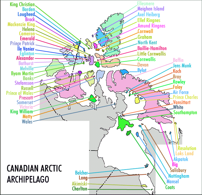
This is an incomplete list of islands of Canada. Arctic islands Islands and island groups in the Arctic Archipelago include (all islands in Nunavut unless noted): Queen Elizabeth Islands The Queen Elizabeth Islands consist of: *Adams Island (Nunavut), Adams Island *Alexander Island (Nunavut), Alexander Island *Baillie-Hamilton Island *Borden Island *Brock Island *Buckingham Island *Byam Martin Island *Cameron Island *Coburg Island *Cornwall Island (Nunavut), Cornwall Island *Devon Island *Eglinton Island *Ellesmere Island *Emerald Isle (Northwest Territories), Emerald Isle *Graham Island (Nunavut), Graham Island *Griffith Island (Nunavut), Griffith Island *Helena Island *Hoved Island *ĂŽle Vanier *King Christian Island *Little Cornwallis Island *Lougheed Island *Mackenzie King Island *Massey Island *Meighen Island *North Kent Island *Pioneer Island (Nunavut), Pioneer Island *Prince Patrick Island *Stor Island *2,092 other minor islands including Hans Island (with Denmark) (), a s ... [...More Info...] [...Related Items...] OR: [Wikipedia] [Google] [Baidu] |
Graham Island (Nunavut)
Graham Island is an uninhabited island in Qikiqtaaluk Region, Nunavut, Canada. A member of the Queen Elizabeth Islands and Arctic Archipelago, it is located in Norwegian Bay off the coast of Ellesmere Island Ellesmere Island (; ) is Canada's northernmost and List of Canadian islands by area, third largest island, and the List of islands by area, tenth largest in the world. It comprises an area of , slightly smaller than Great Britain, and the total .... Located at 77°25'N 90°30'W it has an area of , long and wide. It was named in 1910. Variation There is a second, much smaller (about 2.0 × 0.5 km), Graham Island, also in Nunavut, off Boothia Peninsula. It was named in 1966. References External links Graham Island in the Atlas of Canada - Toporama; Natural Resources CanadaGraham Island in the Atlas of Canada - Toporama; Natural Resources Canada(the smaller one) {{Islands of the Qikiqtaaluk Region Islands of the Queen Elizabeth Islands Uninhabited is ... [...More Info...] [...Related Items...] OR: [Wikipedia] [Google] [Baidu] |
Prince Patrick Island
A member of the Arctic Archipelago, Prince Patrick Island is the westernmost of the Queen Elizabeth Islands in the Northwest Territories of Canada, lying northwest of Melville Island (Northwest Territories and Nunavut), Melville Island. The area of Prince Patrick Island is , making it the List of islands by area, 55th largest island in the world and List of Canadian islands by area, Canada's 14th largest island. It has historically been fast ice, icebound all year, making it one of the least accessible parts of Canada. Located at the entrance of the M'Clure Strait, Prince Patrick Island is uninhabited. The first known sighting of the island was in 1853 by the Irish naval officer George Mecham, when it was explored by him and his fellow Irish explorer Francis Leopold McClintock in the spring of that year during the Edward Belcher expedition. Much later, it was named for Prince Arthur, Duke of Connaught and Strathearn, Prince Arthur William Patrick, Duke of Connaught and Strathearn ... [...More Info...] [...Related Items...] OR: [Wikipedia] [Google] [Baidu] |
Pioneer Island (Nunavut)
Pioneer Island is an island of the Arctic Archipelago, in the territory of Nunavut. It lies at the northern end of Penny Strait, between Devon Island Devon Island (, ) is an island in Canada and the largest desert island, uninhabited island (no permanent residents) in the world. It is located in Baffin Bay, Qikiqtaaluk Region, Nunavut, Canada. It is one of the largest members of the Arctic Ar ... (to the south-east) and Crescent Island (to the north-west). See also * List of Arctic islands References External links Uninhabited islands of Qikiqtaaluk Region Islands of the Queen Elizabeth Islands {{QikiqtaalukNU-island-stub ... [...More Info...] [...Related Items...] OR: [Wikipedia] [Google] [Baidu] |
North Kent Island
North Kent Island is one of the uninhabited Queen Elizabeth Islands in the Canadian arctic islands in the Qikiqtaaluk Region of Nunavut, Canada. It is located in the Cardigan Strait between Devon Island's Colin Archer Peninsula and Ellesmere Island's Simmons Peninsula. Geography The island's terrain is flat-topped and ice-capped, with steep cliffs. Fauna North Kent Island is a Canadian Important Bird Area (#NU052), and an International Biological Program site. Notable bird species include black guillemot, common eider, glaucous gull, and Thayer's gull. Walrus, bearded seal, ringed seal, and narwhal frequent the area. References External links North Kent Islandin the Atlas of Canada The Atlas of Canada () is an online atlas published by Natural Resources Canada that has information on every city, town, village, and hamlet in Canada. It was originally a print atlas, with its first edition being published in 1906 by geographer ... - Toporama; Natural Resources Canada ... [...More Info...] [...Related Items...] OR: [Wikipedia] [Google] [Baidu] |
Meighen Island
Meighen Island is an uninhabited member of the Queen Elizabeth Islands, part of the Arctic Archipelago, in the Qikiqtaaluk Region of Nunavut, Canada. Features and history Located at , it measures in size and is topped with an ice cap. The island is permanently icebound, and its northwestern coast faces onto the open Arctic Ocean. Unlike many Canadian Arctic islands, no traces of Inuit or Thule people, Thule camps have been found, suggesting the island has never been inhabited, likely due to its extreme northern latitude. In 1909, two Inuit who had participated in Frederick Cook's polar expedition provided a map to Robert Peary that showed they had travelled and spent a night on a then unknown island with the position of Meighen Island. The map and testimony of the Inuit in question were published in an article by Peary in the ''Chicago Daily Tribune''. In 1916, Vilhjalmur Stefansson's Canadian Arctic Expedition 1913-1916, Canadian Arctic Expedition sighted and landed on Meigh ... [...More Info...] [...Related Items...] OR: [Wikipedia] [Google] [Baidu] |
Massey Island
Massey Island is an uninhabited island in the Bathurst Island group, Qikiqtaaluk Region, Nunavut, Canada. It is located in the Arctic Ocean, south of ĂŽle Vanier (across Pearse Strait) and north of Alexander Island and ĂŽle Marc (across Boyer Strait). It has an area of , long and wide. The island is named for former Governor General of Canada Vincent Massey. References Sea islands: Atlas of Canada; Natural Resources Canada External links Massey Islandin the Atlas of Canada The Atlas of Canada () is an online atlas published by Natural Resources Canada that has information on every city, town, village, and hamlet in Canada. It was originally a print atlas, with its first edition being published in 1906 by geographer ... - Toporama; Natural Resources Canada Islands of the Queen Elizabeth Islands Uninhabited islands of Qikiqtaaluk Region {{QikiqtaalukNU-island-stub ... [...More Info...] [...Related Items...] OR: [Wikipedia] [Google] [Baidu] |
Mackenzie King Island
Mackenzie King Island is one of the uninhabited Queen Elizabeth Islands in northern Canada. It lies north of Melville Island and south of Borden Island, and like them is divided when it comes to administration. Most of the island is in Northwest Territories, while its easternmost portion lies in Nunavut. The border runs along the 110th meridian west. Mackenzie King has an area of , long in northeast or in southeast and wide, making it the 116th largest island in the world, and Canada's 26th largest island. History The first known visit to the island was by Vilhjalmur Stefansson in 1915, and it was later named for William Lyon Mackenzie King William Lyon Mackenzie King (December 17, 1874 – July 22, 1950) was a Canadian statesman and politician who was the tenth prime minister of Canada for three non-consecutive terms from 1921 to 1926, 1926 to 1930, and 1935 to 1948. A Liberal .... References Further reading * Vilks, G. ''Foraminiferal Study of East Bay, ... [...More Info...] [...Related Items...] OR: [Wikipedia] [Google] [Baidu] |
Lougheed Island
Lougheed Island is one of the uninhabited members of the Queen Elizabeth Islands of the Arctic Archipelago in the Qikiqtaaluk Region, Nunavut. It measures in size. It is relatively isolated compared to other Canadian Arctic islands, and is located in the Arctic Ocean, halfway between Ellef Ringnes Island to the northeast and Melville Island to the southwest. It is part of the Findlay Group. History The first known sighting of the island was in 1916 by Vilhjalmur Stefansson, during his Canadian Arctic Expedition. The island is named for Canadian businessperson and politician James Alexander Lougheed. On April 14, 1993, Environment Canada revoked a permit issued to Panarctic Oils Ltd. to dispose of 400 tonnes of scrap metal in the ocean off Lougheed Island. The decision was taken in response to concerns expressed by residents of Grise Fiord, Resolute, Arctic Bay and Pond Inlet. Instead of disposing of the material at sea, a research project was initiated to evaluate t ... [...More Info...] [...Related Items...] OR: [Wikipedia] [Google] [Baidu] |
Little Cornwallis Island
Little Cornwallis Island is one of the Queen Elizabeth Islands in the Canadian Arctic islands in Nunavut, Canada. It is located at 75°30'N 96°30'W, between Cornwallis Island and Bathurst Island in McDougall Sound, and measures . It is uninhabited. Little Cornwallis Island was the home to Polaris Mine, the most poleward base-metal mine in the world. In 1960 a vast concentration of zinc and lead was discovered on the island during mapping for oil permits. Cominco acquired land in the area and a gravity survey in 1970 detected a large anomaly. By 1973 surface drilling and underground development had outlined the Polaris ore body and defined reserves of about 25 million tons grading approximately 14% zinc and 4% lead. A mining facility was constructed on a barge at Trois-Rivières, Quebec and towed to the island; arriving in mid August 1981. Production commenced in 1982. The mile-long gravel runway allowed aircraft as large as the Boeing 727 and Boeing 737 to service the mi ... [...More Info...] [...Related Items...] OR: [Wikipedia] [Google] [Baidu] |
King Christian Island
King Christian Island is an uninhabited member of the Arctic Archipelago in the Sverdrup Islands, a part of the Queen Elizabeth Islands archipelago, in the Qikiqtaaluk Region of Nunavut, Canada. It lies in the Arctic Ocean, from the southwestern coast of Ellef Ringnes Island, separated by the Danish Strait. The island has an area of , measures long and wide. History The first European to visit the island was Gunnar Isachsen in 1901. Vilhjalmur Stefansson charted its southern coast in 1916. In 1970, Panarctic Oils drilled an exploration well (number D18) on King Christian Island which blew out of control and caught fire. After drilling down to , gas began to flow to the surface, caught fire and burned the rig. Panarctic estimated the gas flow at per day, the largest blowout in Canadian history. References External links King Christian Islandin the Atlas of Canada The Atlas of Canada () is an online atlas published by Natural Resources Canada that has information o ... [...More Info...] [...Related Items...] OR: [Wikipedia] [Google] [Baidu] |
ĂŽle Vanier
Île Vanier is one of the Queen Elizabeth Islands of the Canadian arctic islands in Nunavut, Canada. Located at 76° 10′ N 103° 15′ W, it has an area of . It has length of and width of . To the north, across the Arnott Strait, is Cameron Island, and to the south, across the Pearse Strait, is Massey Island. Île Vanier is uninhabited. The first known sighting of the island was by Robert Dawes Aldrich in 1851, but its insular nature was not proven until the 1950s. Adam Range reaches elevations in excess of 220 metres. References External linksVanier Islandin the Atlas of Canada The Atlas of Canada () is an online atlas published by Natural Resources Canada that has information on every city, town, village, and hamlet in Canada. It was originally a print atlas, with its first edition being published in 1906 by geographer ... - Toporama; Natural Resources Canada Islands of the Queen Elizabeth Islands Uninhabited islands of Qikiqtaaluk Reg ... [...More Info...] [...Related Items...] OR: [Wikipedia] [Google] [Baidu] |


