|
List Of Hospitals In Madagascar ...
This is a list of hospitals in Madagascar. In 2019, there were 2,677 medical facilities in Madagascar, including 125 hospitals. The other facilities are small health centers and posts. Since most of the hospitals, dispensaries and medical centers are located in urban areas, access to medical care remains beyond the reach of many. Around 35% of the population live more than 10 km from a health facility. Hospitals The table below lists the hospitals in Madagascar with the name, city and region, ownership, and coordinates. The map link below the table shows these hospitals on a map of Madagascar. References {{DEFAULTSORT:Hospitals In Madagascar Hospitals in Madagascar Madagascar Madagascar Hospitals A hospital is a health care institution providing patient treatment with specialized health science and auxiliary healthcare staff and medical equipment. The best-known type of hospital is the general hospital, which typically has an emerge ... [...More Info...] [...Related Items...] OR: [Wikipedia] [Google] [Baidu] |
Madagascar
Madagascar (; mg, Madagasikara, ), officially the Republic of Madagascar ( mg, Repoblikan'i Madagasikara, links=no, ; french: République de Madagascar), is an island country in the Indian Ocean, approximately off the coast of East Africa across the Mozambique Channel. At Madagascar is the world's List of island countries, second-largest island country, after Indonesia. The nation is home to around 30 million inhabitants and consists of the island of Geography of Madagascar, Madagascar (the List of islands by area, fourth-largest island in the world), along with numerous smaller peripheral islands. Following the prehistoric breakup of the supercontinent Gondwana, Madagascar split from the Indian subcontinent around 90 million years ago, allowing native plants and animals to evolve in relative isolation. Consequently, Madagascar is a biodiversity hotspot; over 90% of wildlife of Madagascar, its wildlife is endemic. Human settlement of Madagascar occurred during or befo ... [...More Info...] [...Related Items...] OR: [Wikipedia] [Google] [Baidu] |
Analamanga
Analamanga is a region in central Madagascar, containing the capital Antananarivo and its surrounding metropolitan area. The region has an area of , and had a population of 3,618,128 in 2018. Administrative divisions Analamanga Region is divided into eight districts, which are sub-divided into 137 communes. * Ambohidratrimo District - 24 communes * Andramasina District - 14 communes * Anjozorobe District - 18 communes * Ankazobe District - 15 communes * Antananarivo-Atsimondrano District - 26 communes * Antananarivo-Avaradrano District - 16 communes * Antananarivo-Renivohitra District - 1 commune; the city of Antananarivo * Manjakandriana District - 23 communes Geography The region extends mainly towards the north of the capital. It is bordered by Betsiboka to the north, Bongolava and Itasy to the west, Alaotra Mangoro to the east, and Vakinankaratra to the south. Rivers The main rivers are the Betsiboka River and the Ikopa River. Major lakes Lake Mantasoa (1375 ha) and Tsiazom ... [...More Info...] [...Related Items...] OR: [Wikipedia] [Google] [Baidu] |
Andilamena
Andilamena is a rural commune in Madagascar. It belongs to the district of Andilamena, which is a part of Alaotra-Mangoro Region. The population of the commune was 37,229 in 2018. In addition to primary schooling the town offers secondary education at both junior and senior levels. The town provides access to hospital services to its citizens. The majority 65% of the population of the commune are farmers, while an additional 10% receives their livelihood from raising livestock. The most important crop is rice, while other important products are peanuts, maize and cassava ''Manihot esculenta'', common name, commonly called cassava (), manioc, or yuca (among numerous regional names), is a woody shrub of the spurge family, Euphorbiaceae, native to South America. Although a perennial plant, cassava is extensively .... Industry and services provide employment for 1% and 24% of the population, respectively. History Andilamena, it is at this place, in October 2000, where an impor ... [...More Info...] [...Related Items...] OR: [Wikipedia] [Google] [Baidu] |
Sava Region
Sava is a region in northern Madagascar. Its capital is Sambava. Until 2009 Sava belonged to Antsiranana Province. The region is situated at the northern part of the east coast of Madagascar. It is bordered by the region Diana to the north, Sofia to the west, and Analanjirofo to the south. As of 2018, its population was 1,123,013 and the total area is . The region contains wild areas such as Marojejy National Park. The name of the region is composed of the initial letters of its four principal towns: Sambava, Antalaha, Iharana (Vohimaro), and Andapa. Each of these towns claims itself the World Capital of Vanilla, a spice of which the region is the largest producer of in the world (especially the highly sought-after Bourbon vanilla variety). The economic importance of vanilla cultivation in the Sava Region encouraged the reconstruction of the road that connects the towns, called the ''Route de la vanille'' (The Vanilla Route), in the latter half of 2005. However, due to the volat ... [...More Info...] [...Related Items...] OR: [Wikipedia] [Google] [Baidu] |
Andapa
Andapa is a town and commune ( mg, firaisana) in northern Madagascar. It belongs to the district of Andapa, which is a part of Sava Region. According to 2001 commune census the population of Andapa was 27,618. Andapa is served by a local airport. It is also a site of industrial-scale mining. The majority 88% of the population are farmers, while an additional 0.5% receives their livelihood from raising livestock. The most important crop is rice, while other important products are beans, tomatoes and vanilla. Industry and services provide employment for 1.5% and 10% of the population, respectively. Geography The capital of the Sava Region, Sambava is at a distance of 108 km. It is situated at the |
Sofia Region
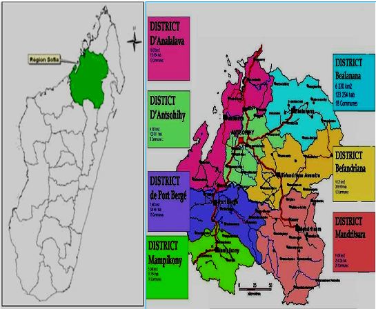
Sofia is a region in northern Madagascar. It is named for the Sofia River. The region covers 50,100 km² and had a population of 1,500,227 in 2018. The administrative capital is Antsohihy. Administrative divisions Sofia Region is divided into seven districts, which are sub-divided into 108 communes. * Analalava District - 11 communes * Antsohihy District - 12 communes * Bealanana District - 13 communes * Befandriana-Nord District - 12 communes * Boriziny-Vaovao District - 15 communes * Mampikony District - 6 communes * Mandritsara District - 22 communes Transport Airports *Analalava Airport * Antsohihy Airport * Bealanana Airport * Befandriana-Avaratra Airport * Mampikony Airport *Mandritsara Airport * Boriziny Vaovao Airport Roads Sofia is crossed by the National Road 4 (Antananarivo-Mahajanga), National Road 6 (Antsohihy-Diego Suarez), the National road 31 (Antsohihy to Mandritsara) and National road 32 (Antsohihy to Bealanana). Protected Areas *Bongolava forest ... [...More Info...] [...Related Items...] OR: [Wikipedia] [Google] [Baidu] |
Analalava
Analalava is a coastal town and commune ( mg, kaominina) in north-western Madagascar over the Mozambique Channel. It is approximately 150 kilometres north of Mahajanga and some 430 kilometres north of the capital Antananarivo. It belongs to the district of Analalava, which is a part of Sofia Region. The population of the commune was estimated to be approximately 10,000 in 2001 commune census. Analalava is served by a local Analalava Airport. In addition to primary schooling the town offers secondary education at both junior and senior levels. The town has a permanent court and hospital. The majority 60% of the population works in fishing. 25% are farmers, while an additional 10% receives their livelihood from raising livestock. The most important crop is rice, while other important products are coconuts and cassava. Services provide employment for 5% of the population. National Parks The Sahamalaza National Park Sahamalaza National Park is in the northwestern part of Madagas ... [...More Info...] [...Related Items...] OR: [Wikipedia] [Google] [Baidu] |
Amparafaravola
Amparafaravola is a rural municipality in Madagascar. It belongs to the district of Amparafaravola, which is a part of Alaotra-Mangoro Region. The population of the municipality was 33,299 in 2018 that are distributed in 21 Fokontany (villages) that are: Marotaolana, Antanambao, Ambohimandroso, Ambohipeno, Maritampona, Ampasimbola, Ambalamirahona, Analamiranga, Amparafaravola, Ambodihasina, Besarety, Ambalafarisoa, Ampilahoana, Antsakoana, Morarano-Nord, Ambodimanga, Ambondrona, Andilana Sud, Sahamamy, Ambondroala and Ambohivorikely. It is situated at 65 km from Ambatondrazaka. In addition to primary schooling, the town offers secondary education at both junior and senior levels. The town provides access to hospital services for its citizens. Over 80% of the population of the commune are farmers and 10% receive their livelihood from raising livestock. The most important crop is rice. Other important agricultural products include maize and cassava ''Manihot esculenta'', comm ... [...More Info...] [...Related Items...] OR: [Wikipedia] [Google] [Baidu] |
Atsimo-Andrefana
Atsimo-Andrefana is a region of Madagascar. It borders Menabe in north, Amoron'i Mania and Haute Matsiatra in northeast, Ihorombe and Anosy in east and Androy in southeast. The capital is Toliara and the population was 1,799,088 in 2018. Atsimo Andrefana is geographically the largest of all Malagasy regions with an area of . Administrative divisions Atsimo-Andrefana Region is divided into nine districts, which are sub-divided into 105 communes. * Ampanihy District - 16 communes * Ankazoabo District - 5 communes * Benenitra District - 5 communes * Betioky Sud District - 5 communes * Beroroha District - 19 communes * Morombe District - 8 communes * Sakaraha District - 11 communes * Toliary I District - 1 commune * Toliara II District - 19 communes Transport Airports *Ampanihy Airport *Andavadoaka Airport *Ankazoabo Airport *Beroroha Airport *Betioky Airport *Morombe Airport * Tanandava Airport *Toliara Airport Protected areas In Atsimo-Andrefana are found the following protecte ... [...More Info...] [...Related Items...] OR: [Wikipedia] [Google] [Baidu] |
Ampanihy
Ampanihy or Ampanihy Ouest is a town in the Atsimo-Andrefana Region, Madagascar. It is home of the Ampanihy Airport and is crossed by the Route Nationale 10. Economy The weaving of rugs from mohair Mohair (pronounced ) is a fabric or yarn made from the hair of the Angora goat. (This should not be confused with Angora wool, which is made from the fur of the Angora rabbit.) Both durable and resilient, mohair is notable for its high luster ... is the most important economic activity since 1914. References Populated places in Atsimo-Andrefana {{AtsimoAndrefana-geo-stub ... [...More Info...] [...Related Items...] OR: [Wikipedia] [Google] [Baidu] |
Amoron'i Mania
Amoron'i Mania is a region in central Madagascar bordering Vakinankaratra Region in north, Atsinanana in northeast, Vatovavy-Fitovinany in southeast, Haute Matsiatra in south, Atsimo-Andrefana in southwest and Menabe in west. The capital of the region is Ambositra, and the population was 833,919 in 2018. The area of the region is . Administrative divisions Amoron'i Mania Region is divided into four districts, which are sub-divided into 53 communes. * Ambatofinandrahana District - 9 communes * Ambositra District - 21 communes * Fandriana District - 13 communes * Manandriana District - 10 communes Protected areas *Part of Fandriana-Vondrozo Corridor *Part of Marolambo National Park * Itremo New Protected Area Itremo is a town and commune in Madagascar. It belongs to the district of Ambatofinandrahana, which is a part of Amoron'i Mania Region. The population of the commune was estimated to be approximately 7,000 in 2001 commune census. Only primary s ... References EDBM ... [...More Info...] [...Related Items...] OR: [Wikipedia] [Google] [Baidu] |

