|
Langworth Railway Station
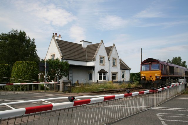
Langworth railway station was a railway station in Langworth, Lincolnshire Lincolnshire (abbreviated Lincs.) is a county in the East Midlands of England, with a long coastline on the North Sea to the east. It borders Norfolk to the south-east, Cambridgeshire to the south, Rutland to the south-west, Leicestershire ..., opened in 1848 and closed in 1965. On 30 June 2015, a freight train was derailed near the site of the station. On 3 March 2017 The station building was damaged when a stolen car drove through the railway barriers, injuring the two teenage boys in the car. References Disused railway stations in Lincolnshire Railway stations in Great Britain opened in 1848 Railway stations in Great Britain closed in 1965 Former Great Central Railway stations {{EastMidlands-railstation-stub ... [...More Info...] [...Related Items...] OR: [Wikipedia] [Google] [Baidu] |
Ordnance Survey National Grid
The Ordnance Survey National Grid reference system (OSGB) (also known as British National Grid (BNG)) is a system of geographic grid references used in Great Britain, distinct from latitude and longitude. The Ordnance Survey (OS) devised the national grid reference system, and it is heavily used in their survey data, and in maps based on those surveys, whether published by the Ordnance Survey or by commercial map producers. Grid references are also commonly quoted in other publications and data sources, such as guide books and government planning documents. A number of different systems exist that can provide grid references for locations within the British Isles: this article describes the system created solely for Great Britain and its outlying islands (including the Isle of Man); the Irish grid reference system was a similar system created by the Ordnance Survey of Ireland and the Ordnance Survey of Northern Ireland for the island of Ireland. The Universal Transverse Merca ... [...More Info...] [...Related Items...] OR: [Wikipedia] [Google] [Baidu] |
Great Grimsby And Sheffield Junction Railway
The Great Grimsby and Sheffield Junction Railway was an early British railway company which existed between 1845 and 1847 with the intention of providing rail services between Grimsby, New Holland and Gainsborough in the county of Lincolnshire. It amalgamated with the Sheffield, Ashton-Under-Lyne and Manchester Railway and the Sheffield and Lincolnshire Junction Railway, the three being renamed the Manchester, Sheffield and Lincolnshire Railway in 1847. History The company As a company, it was the oldest of the three, having begun in 1796 as the Grimsby Haven Company, when the harbour was enlarged. When new fishing grounds were discovered on the Dogger Bank trade increased and in 1845 the Grimsby Haven became part of the Grimsby Docks Company. Five of its directors were also on the board of the proposed Great Grimsby & Sheffield Junction Railway, intended to connect with the proposed Sheffield and Lincolnshire line. The decision was taken to amalgamate the two undertakings. Both ... [...More Info...] [...Related Items...] OR: [Wikipedia] [Google] [Baidu] |
Great Central Railway
The Great Central Railway in England was formed when the Manchester, Sheffield and Lincolnshire Railway changed its name in 1897, anticipating the opening in 1899 of its London Extension. On 1 January 1923, the company was grouped into the London and North Eastern Railway. History New name On assuming its new title, the Great Central Railway had a main line from Manchester London Road Station via , Sheffield Victoria, and Grimsby to . A second line left the line at Penistone and served , and Scunthorpe, before rejoining the Grimsby line at . Other lines linked Sheffield to Barnsley (via ) and Doncaster (via Rotherham) and also and Wrawby Junction. Branch lines in north Lincolnshire ran to Barton-upon-Humber and New Holland and served ironstone quarries in the Scunthorpe area. In the Manchester area, lines ran to Stalybridge and Glossop. In the 1890s, the MS&LR began constructing its Derbyshire lines, the first part of its push southwards. Leaving its east–west mai ... [...More Info...] [...Related Items...] OR: [Wikipedia] [Google] [Baidu] |
Langworth Level Crossing - Geograph
Langworth is a small village in the West Lindsey district of Lincolnshire, England. It is situated north-east from the city and county town of Lincoln, and on the A158 road Lincoln to Skegness road. It is in the civil parish of Barlings. Community The village has two public houses and two garages. Langworth railway station, on the Great Central Railway Grimsby to Lincoln line, has closed, but the line still runs through the village, crossing the A158. The village is in an area prone to flooding. The Environment Agency gives flood warnings for the Barlings Eau waterway, which runs just north-west of the village. Particularly extensive flooding occurred in 2007. School Langworth's Boulters primary school closed in 1989, after which its pupils transferred to the newly built Ellison Boulters School in neighbouring Scothern. Church Langworth church is dedicated to St Hugh. The church is a 1960–62 rebuilding, by Haynes and Johnson of Brigg, of the Walmsgate Hall chap ... [...More Info...] [...Related Items...] OR: [Wikipedia] [Google] [Baidu] |
Langworth
Langworth is a small village in the West Lindsey district of Lincolnshire, England. It is situated north-east from the city and county town of Lincoln, and on the A158 road Lincoln to Skegness road. It is in the civil parish of Barlings. Community The village has two public houses and two garages. Langworth railway station, on the Great Central Railway Grimsby to Lincoln line, has closed, but the line still runs through the village, crossing the A158. The village is in an area prone to flooding. The Environment Agency gives flood warnings for the Barlings Eau waterway, which runs just north-west of the village. Particularly extensive flooding occurred in 2007. School Langworth's Boulters primary school closed in 1989, after which its pupils transferred to the newly built Ellison Boulters School in neighbouring Scothern. Church Langworth church is dedicated to St Hugh. The church is a 1960–62 rebuilding, by Haynes and Johnson of Brigg, of the Walmsgate Hall chapel, its ... [...More Info...] [...Related Items...] OR: [Wikipedia] [Google] [Baidu] |
Lincolnshire
Lincolnshire (abbreviated Lincs.) is a county in the East Midlands of England, with a long coastline on the North Sea to the east. It borders Norfolk to the south-east, Cambridgeshire to the south, Rutland to the south-west, Leicestershire and Nottinghamshire to the west, South Yorkshire to the north-west, and the East Riding of Yorkshire to the north. It also borders Northamptonshire in the south for just , England's shortest county boundary. The county town is Lincoln, where the county council is also based. The ceremonial county of Lincolnshire consists of the non-metropolitan county of Lincolnshire and the area covered by the unitary authorities of North Lincolnshire and North East Lincolnshire. Part of the ceremonial county is in the Yorkshire and the Humber region of England, and most is in the East Midlands region. The county is the second-largest of the English ceremonial counties and one that is predominantly agricultural in land use. The county is fourth-larg ... [...More Info...] [...Related Items...] OR: [Wikipedia] [Google] [Baidu] |
Reepham (Lincolnshire) Railway Station
Reepham railway station was a railway station in Reepham, Lincolnshire which opened in 1848 and closed in 1965,British Railways Atlas. 1947. p.17 though the line is still in use. It was located a few miles east of Lincoln. The station's building is now a private residence. The former coal yard and sidings are occupied by two bungalows. There is no trace of the platforms which were located either side of the level crossing, the staggered layout being typical of the company that built the line. The manual signal box and crossing gates were removed a few years ago and replaced by barriers. They are controlled by the still staffed signal box at Langworth further up the line towards Market Rasen, the next still-in-use station on the line. The removal of the staffed signal box has resulted in much longer waiting times for road traffic and pedestrians since the control was moved to Langworth. Up to closure, the station was used by grammar school pupils to go to De Aston School in Mar ... [...More Info...] [...Related Items...] OR: [Wikipedia] [Google] [Baidu] |
Snelland Railway Station
Snelland railway station was a station in Snelland, Lincolnshire Lincolnshire (abbreviated Lincs.) is a county in the East Midlands of England, with a long coastline on the North Sea to the east. It borders Norfolk to the south-east, Cambridgeshire to the south, Rutland to the south-west, Leicestershire ..., opened in 1848 as part of the ''Sheffield and Lincolnshire Extension Railway''. and closed in 1965. References External links * Disused railway stations in Lincolnshire Railway stations in Great Britain opened in 1848 Railway stations in Great Britain closed in 1965 Former Great Central Railway stations 1848 establishments in England 1965 disestablishments in England {{EastMidlands-railstation-stub ... [...More Info...] [...Related Items...] OR: [Wikipedia] [Google] [Baidu] |
Railway Stations In Great Britain Opened In 1848
Rail transport (also known as train transport) is a means of transport that transfers passengers and goods on wheeled vehicles running on rails, which are incorporated in tracks. In contrast to road transport, where the vehicles run on a prepared flat surface, rail vehicles (rolling stock) are directionally guided by the tracks on which they run. Tracks usually consist of steel rails, installed on sleepers (ties) set in ballast, on which the rolling stock, usually fitted with metal wheels, moves. Other variations are also possible, such as "slab track", in which the rails are fastened to a concrete foundation resting on a prepared subsurface. Rolling stock in a rail transport system generally encounters lower frictional resistance than rubber-tyred road vehicles, so passenger and freight cars (carriages and wagons) can be coupled into longer trains. The operation is carried out by a railway company, providing transport between train stations or freight customer facilit ... [...More Info...] [...Related Items...] OR: [Wikipedia] [Google] [Baidu] |
Railway Stations In Great Britain Closed In 1965
Rail transport (also known as train transport) is a means of transport that transfers passengers and goods on wheeled vehicles running on rails, which are incorporated in tracks. In contrast to road transport, where the vehicles run on a prepared flat surface, rail vehicles (rolling stock) are directionally guided by the tracks on which they run. Tracks usually consist of steel rails, installed on sleepers (ties) set in ballast, on which the rolling stock, usually fitted with metal wheels, moves. Other variations are also possible, such as "slab track", in which the rails are fastened to a concrete foundation resting on a prepared subsurface. Rolling stock in a rail transport system generally encounters lower frictional resistance than rubber-tyred road vehicles, so passenger and freight cars (carriages and wagons) can be coupled into longer trains. The operation is carried out by a railway company, providing transport between train stations or freight customer facili ... [...More Info...] [...Related Items...] OR: [Wikipedia] [Google] [Baidu] |


