|
Kōshin'etsu Region
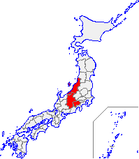
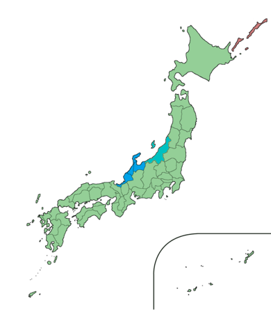
is a subregion of the Chūbu region in Japan consisting of Yamanashi, Nagano, and Niigata prefectures. The name Kōshin'etsu is a composite formed from the names of old provinces which are adjacent to each other — Kai (now Yamanashi), Shinano (now Nagano) and Echigo (now Niigata). The region is surrounded by the Sea of Japan to its north west, Hokuriku region to its west, Tōkai region to its south west, Kantō region to its south east, and Tōhoku region to its north east. The name for this geographic area is usually combined with Kantō region (as in "Kantō-Kōshin'etsu""Abstracts from the 25th Kanto-Koshinetsu regional meeting of the Japanese Society of Nuclear Medicine" (JSNM), ''Japanese Journal of Nuclear Medicine'' (Jpn J Nucl Med) 23(10):1503-1511, October 1986.); and it is sometimes combined with Hokuriku region (as in "Kantō-Kōshin'etsu-Hokuriku" or "Hokuriku-Kōshin'etsu"). Corporate usage * Nippon Telegraph & Telephone directories categorize phone numbe ... [...More Info...] [...Related Items...] OR: [Wikipedia] [Google] [Baidu] |
Sea Of Japan
The Sea of Japan is the marginal sea between the Japanese archipelago, Sakhalin, the Korean Peninsula, and the mainland of the Russian Far East. The Japanese archipelago separates the sea from the Pacific Ocean. Like the Mediterranean Sea, it has almost no tides due to its nearly complete enclosure from the Pacific Ocean. This isolation also affects faunal diversity and salinity, both of which are lower than in the open ocean. The sea has no large islands, bays or capes. Its water balance is mostly determined by the inflow and outflow through the straits connecting it to the neighboring seas and the Pacific Ocean. Few rivers discharge into the sea and their total contribution to the water exchange is within 1%. The seawater has an elevated concentration of dissolved oxygen that results in high biological productivity. Therefore, fishing is the dominant economic activity in the region. The intensity of shipments across the sea has been moderate owing to political issues, but it ... [...More Info...] [...Related Items...] OR: [Wikipedia] [Google] [Baidu] |
Shin'etsu Region
is a geographical region of Japan. The area encompasses the old provinces of Shinano and Echigo. Though the name is a combination of those two provinces, the region also contains Sado Island from Sado Province. It is located in the modern-day prefectures of Nagano and Niigata. Corporate usage The name Shin-Etsu is used in the name of related multinational chemical companies. The Shin'etsu Main Line is part of Japan Railways service running from Shinonoi Station in Nagano Prefecture to Niigata Station in Niigata Prefecture,. In 1926, the Shinetsu Electric Company diversified as Shin'etsu Nitrogenous Fertilizer. Economy The economy of Shin'etsu subregion is large and highly diversified with a strong focus on silverware, electronics, information technology, precision machinery, agriculture and food products, and tourism. It also produces crude oil. Until 1989, Shin'etsu subregion also had a vibrant mining economy specifically of gold in Sado Island. The Cities of Sanjō, Ni ... [...More Info...] [...Related Items...] OR: [Wikipedia] [Google] [Baidu] |
Japanese Society Of Nuclear Medicine
Japanese may refer to: * Something from or related to Japan, an island country in East Asia * Japanese language, spoken mainly in Japan * Japanese people, the ethnic group that identifies with Japan through ancestry or culture ** Japanese diaspora, Japanese emigrants and their descendants around the world * Japanese citizens, nationals of Japan under Japanese nationality law ** Foreign-born Japanese, naturalized citizens of Japan * Japanese writing system, consisting of kanji and kana * Japanese cuisine, the food and food culture of Japan See also * List of Japanese people * * Japonica (other) * Japonicum * Japonicus * Japanese studies Japanese studies (Japanese: ) or Japan studies (sometimes Japanology in Europe), is a sub-field of area studies or East Asian studies involved in social sciences and humanities research on Japan. It incorporates fields such as the study of Japanese ... {{disambiguation Language and nationality disambiguation pages ... [...More Info...] [...Related Items...] OR: [Wikipedia] [Google] [Baidu] |
Nippon Telegraph & Telephone
, commonly known as NTT, is a Japanese telecommunications company headquartered in Tokyo, Japan. Ranked 55th in ''Fortune'' Global 500, NTT is the fourth largest telecommunications company in the world in terms of revenue, as well as the third largest publicly traded company in Japan after Toyota and Sony, as of June 2022. The company is incorporated pursuant to the NTT Law (). The purpose of the company defined by the law is to own all the shares issued by Nippon Telegraph and Telephone East Corporation (NTT East) and Nippon Telegraph and Telephone West Corporation (NTT West) and to ensure proper and stable provision of telecommunications services all over Japan including remote rural areas by these companies as well as to conduct research relating to the telecommunications technologies that will form the foundation for telecommunications. On 1 July 2019, NTT Corporation launched NTT Ltd., an $11 billion de facto holding company business consisting of 28 brands from across NTT S ... [...More Info...] [...Related Items...] OR: [Wikipedia] [Google] [Baidu] |
Tōhoku Region
The , Northeast region, or consists of the northeastern portion of Honshu, the largest island of Japan. This traditional region consists of six prefectures (''ken''): Akita, Aomori, Fukushima, Iwate, Miyagi, and Yamagata. Tōhoku retains a reputation as a remote, scenic region with a harsh climate. In the 20th century, tourism became a major industry in the Tōhoku region. History Ancient & Classical period In mythological times, the area was known as Azuma (吾妻, あづま) and corresponded to the area of Honshu occupied by the native Emishi and Ainu. The area was historically the Dewa and the Michinoku regions, a term first recorded in (654). There is some variation in modern usage of the term "Michinoku". Tōhoku's initial historical settlement occurred between the seventh and ninth centuries, well after Japanese civilization and culture had become firmly established in central and southwestern Japan. The last stronghold of the indigenous Emishi on Honshu and ... [...More Info...] [...Related Items...] OR: [Wikipedia] [Google] [Baidu] |
Kantō Region
The is a geographical area of Honshu, the largest island of Japan. In a common definition, the region includes the Greater Tokyo Area and encompasses seven prefectures: Gunma, Tochigi, Ibaraki, Saitama, Tokyo, Chiba and Kanagawa. Slightly more than 45 percent of the land area within its boundaries is the Kanto Plain. The rest consists of the hills and mountains that form land borders with other regions of Japan. As the Kanto region contains Tokyo, the capital and largest city of Japan, the region is considered the center of Japan's politics and economy. According to the official census on October 1, 2010, by the Japan Statistics Bureau, the population was 42,607,376, amounting to approximately one third of the total population of Japan. Other definitions The Kantō regional governors' association (関東地方知事会, ''Kantō chihō chijikai'') assembles the prefectural governors of Ibaraki, Tochigi, Gunma, Saitama, Chiba, Tokyo, Kanagawa, Yamanashi, Nagano and ... [...More Info...] [...Related Items...] OR: [Wikipedia] [Google] [Baidu] |
Tōkai Region
The is a subregion of the Chūbu region and Kansai region in Japan that runs along the Pacific Ocean. The name comes from the Tōkaidō, one of the Edo Five Routes. Because Tōkai is a sub-region and is not officially classified, there is some disagreement about where exactly the region begins and ends, however Japanese maps widely conclude that the region includes Shizuoka, Aichi, Gifu and Mie prefectures. The largest major city in the region is Nagoya and the Chūkyō Metropolitan Area (Nagoya Metropolitan Area) makes up a large portion of the region and has Japan's third strongest economy. The business influence of this urban area sometimes extends out into the outlying areas of the three prefectures centered on Nagoya which are Aichi, Gifu, and Mie; this area is sometimes referred to as the Chūkyō region. Tōkai is a heavy manufacturing area and is one of the most industrial regions in Japan. Its coast is lined with densely populated cities with economies that thr ... [...More Info...] [...Related Items...] OR: [Wikipedia] [Google] [Baidu] |
Hokuriku Region
The was located in the northwestern part of Honshu, the main island of Japan. It lay along the Sea of Japan within the Chūbu region, which it is currently a part of. It is almost equivalent to Koshi Province and Hokurikudō area in pre-modern Japan. Since the Heian period until the Edo period the region was a core recipient of population, the population grew to be much larger proportionately than it is today, despite the rural character. With the growth of urban centers in the 20th century, particularly Tokyo and Nagoya, Chūkyō, the Hokuriku has steadily declined in importance to become relative backwaters. The region is also known for traditional culture that originated from elsewhere that has been long lost along the Taiheiyō Belt. The Hokuriku region includes the four prefectures of Ishikawa Prefecture, Ishikawa, Fukui Prefecture, Fukui, Niigata Prefecture, Niigata and Toyama Prefecture, Toyama, although Niigata is sometimes included in one of the following regions: * ... [...More Info...] [...Related Items...] OR: [Wikipedia] [Google] [Baidu] |
Echigo Province
was an old province in north-central Japan, on the shores of the Sea of Japan. It bordered on Uzen, Iwashiro, Kōzuke, Shinano, and Etchū Provinces. Nussbaum, Louis-Frédéric. (2005). "''Echigo''" in . It corresponds today to Niigata Prefecture, minus the island of Sado. Its abbreviated form name was , with Echizen and Etchū Provinces. Under the ''Engishiki'' classification system, Echigo was ranked as one of the 35 "superior countries" (上国) in terms of importance, and one of the 30 "far countries" (遠国) in terms of distance from the capital. Echigo and Kōzuke Province were known as the Jōetsu region. History In the late 7th century, during the reign of Emperor Monmu, the ancient province of was divided into three separate provinces: Echizen, Etchū, and Echigo. The new Echigo Province consisted of Iwafune and Nutari Districts, and was one of two border provinces of the Yamato state with the Emishi (the other being Mutsu). In 702, Echigo was give ... [...More Info...] [...Related Items...] OR: [Wikipedia] [Google] [Baidu] |
Chūbu Region
The , Central region, or is a region in the middle of Honshu, Honshū, Japan, Japan's main island. In a wide, classical definition, it encompasses nine prefectures (''ken''): Aichi Prefecture, Aichi, Fukui Prefecture, Fukui, Gifu Prefecture, Gifu, Ishikawa Prefecture, Ishikawa, Nagano Prefecture, Nagano, Niigata Prefecture, Niigata, Shizuoka Prefecture, Shizuoka, Toyama Prefecture, Toyama, and Yamanashi Prefecture, Yamanashi. It is located directly between the Kantō region and the Kansai region and includes the major city of Nagoya as well as Pacific Ocean and Sea of Japan coastlines, extensive mountain resorts, and Mount Fuji. The region is the widest part of Honshū and the central part is characterized by high, rugged mountains. The Japanese Alps divide the country into the Pacific Ocean, Pacific side, sunny in winter, and the Sea of Japan side, snowy in winter. Although Mie Prefecture, Mie is part of Kinki/Kansai/Western Japan in traditional geographical regional div ... [...More Info...] [...Related Items...] OR: [Wikipedia] [Google] [Baidu] |
Shinano Province
or is an old province of Japan that is now Nagano Prefecture. Shinano bordered on Echigo, Etchū, Hida, Kai, Kōzuke, Mikawa, Mino, Musashi, Suruga, and Tōtōmi Provinces. The ancient capital was located near modern-day Matsumoto, which became an important city of the province. The World War II–era Japanese aircraft carrier ''Shinano'' was named after this old province. Historical record In 713, the road that traverses Mino and Shinano provinces was widened to accommodate increasing numbers of travelers through the Kiso District of modern Nagano Prefecture. In the Sengoku period, Shinano Province was often split among fiefs and castle towns developed, including Komoro, Ina, and Ueda. Shinano was one of the major centers of Takeda Shingen's power during his wars with Uesugi Kenshin and others. Suwa taisha was designated as the chief Shinto shrine (''ichinomiya'') for the province. [...More Info...] [...Related Items...] OR: [Wikipedia] [Google] [Baidu] |


