|
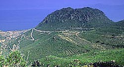
Kypseli, Methana
Kypseli () is situated in the eastern part of the Methana Methana ( el, Μέθανα) is a town and a former municipality on the Peloponnese peninsula, Greece. Since the 2011 local government reform it is part of the municipality Troizinia-Methana, of which it is a municipal unit. The municipal unit has ... volcanic peninsula. It was originally a farming village. The older name of the village is Kosona. Kypseli community comprises also the village Agioi Theodoroi. The population of the village is 47 inhabitants, and the community population is 92 inhabitants according to 2011 census. Historical population References Troizinia-Methana Populated places in Islands (regional unit) {{Attica-geo-stub ... [...More Info...] [...Related Items...] OR: [Wikipedia] [Google] [Baidu] |
Attica (region)
Attica ( el, Περιφέρεια Αττικής, translit=Periféria Attikís, ) is an administrative region of Greece, that encompasses the entire metropolitan area of Athens, the country's capital and largest city. The region is coextensive with the former Attica Prefecture of Central Greece. It covers a greater area than the historical region of Attica. Overview Located on the eastern edge of Central Greece, Attica covers about 3,808 square kilometers. In addition to Athens, it contains within its area the cities of Elefsina, Megara, Laurium, and Marathon, as well as a small part of the Peloponnese peninsula and the islands of Salamis, Aegina, Angistri, Poros, Hydra, Spetses, Kythira, and Antikythera. About 3,800,000 people live in the region, of whom more than 95% are inhabitants of the Athens metropolitan area. In 2019, Attica had the HDI of 0.912, the highest in Greece. Administration The region was established in the 1987 administrative reform, and until 2010 it ... [...More Info...] [...Related Items...] OR: [Wikipedia] [Google] [Baidu] |
Islands (regional Unit)
The Islands Regional Unit ( el, Περιφερειακή ενότητα Νήσων, ''Periphereiaki enotita Nison'') is one of the regional units of Greece. It is part of the region of Attica. The regional unit covers the Saronic Islands, a small part of the Peloponnese peninsula, and a few islands off the eastern Peloponnese coast. Administrative history The municipalities and provinces of Aigina, Agistri, Poros and Salamis was part of the Attica Prefecture and was created in 1833 as part of Attica and Boeotia Prefecture. Cythera, Hydra, Spetses and Troizinia-Methana was originally part of Argolis and Korinthos prefecture until 1929, then part of Prefecture of Attica. In 1964 the newly formed Piraeus Prefecture (Νομός) was created incorporated the Islands which until then was part of Attica Prefecture, after the abolishment of Piraeus Prefecture in 1972 went back again to Attica Prefecture as part of newly formed Piraeus Prefecture (Νομαρχία). As a part of the 20 ... [...More Info...] [...Related Items...] OR: [Wikipedia] [Google] [Baidu] |
Troizinia-Methana
Troizinia-Methana ( el, Τροιζηνία-Μέθανα) is a municipality in the Islands regional unit, Attica, Greece. The seat of the municipality is the town Galatas. The municipality was formed at the 2011 local government reform by the merger of the two former municipalities Methana and Troizina, that became municipal units. Initially named ''Troizinia'', in January 2014 the municipality was renamed ''Troizinia-Methana''. The municipality has an area of 240.858 km2. Province The province of Troizinia ( el, Επαρχία Τροιζηνίας) was one of the provinces of the Attica Prefecture, from 1964 to 1972 of Piraeus Prefecture and later again to Attica prefecture until today. Its territory corresponded with that of the current municipalities Troizinia and Poros Poros ( el, Πόρος) is a small Greece, Greek island-pair in the southern part of the Saronic Gulf, about south from the port of Piraeus and separated from the Peloponnese by a wide sea channel, wi ... [...More Info...] [...Related Items...] OR: [Wikipedia] [Google] [Baidu] |
Methana
Methana ( el, Μέθανα) is a town and a former municipality on the Peloponnese peninsula, Greece. Since the 2011 local government reform it is part of the municipality Troizinia-Methana, of which it is a municipal unit. The municipal unit has an area of 50.161 km2. Methana is situated on a volcanic (the Methana Volcano) peninsula, attached to the Peloponnese. Administratively, it belongs to the Attica region. The town (pop. 892 in 2011) is located north of the road connecting to the rest of the Peloponnese and Galatas. The highest point is (Helona Mountain). The municipal unit has a land area of and a population of 1,657 inhabitants at the 2011 census. The largest settlements besides the town of Methana are Vathý (pop. 129), Megalochóri (115), Kounoupítsa (75), Kypséli (47), Ágioi Theódoroi (45), and Dritsaíika (205) Subdivisions The municipal unit Methana is subdivided into the following communities (constituent villages in brackets): * Kounoupitsa (Kounoupi ... [...More Info...] [...Related Items...] OR: [Wikipedia] [Google] [Baidu] |

