|
Kungala, New South Wales
Kungala is a locality south of Grafton in northern New South Wales, Australia Australia, officially the Commonwealth of Australia, is a Sovereign state, sovereign country comprising the mainland of the Australia (continent), Australian continent, the island of Tasmania, and numerous List of islands of Australia, sma .... The North Coast railway passes through, and a railway station and sidings were provided from 1915 to 1974. At the 2006 census, Kungala had a population of 205 people. The town's name is derived from an aboriginal term meaning "to shout and listen". References {{authority control Towns in New South Wales Northern Rivers North Coast railway line, New South Wales Clarence Valley Council ... [...More Info...] [...Related Items...] OR: [Wikipedia] [Google] [Baidu] |
Electoral District Of Clarence
Clarence is an New South Wales Legislative Assembly electoral districts, electoral district of the New South Wales Legislative Assembly, Legislative Assembly in the Australian state of New South Wales. It includes all of the Clarence Valley Council including Grafton, New South Wales, Grafton, Maclean, New South Wales, Maclean, Yamba, New South Wales, Yamba, Iluka, New South Wales, Illuka, Junction Hill, New South Wales, Junction Hill, Ulmarra, New South Wales, Ulmarra, Coutts Crossing, New South Wales, Coutts Crossing and Glenreagh, New South Wales, Glenreagh, as well as all of the Richmond Valley Council including Casino, New South Wales, Casino, Coraki, New South Wales, Coraki, Woodburn, New South Wales, Woodburn, Evans Head, New South Wales, Evans Head and Tatham, New South Wales, Tatham. History Clarence was created in 1859, replacing the New South Wales part of Electoral district of Clarence and Darling Downs, Clarence and Darling Downs. With the introduction of proportion ... [...More Info...] [...Related Items...] OR: [Wikipedia] [Google] [Baidu] |
Division Of Page
The Division of Page is an Australian electoral division in the state of New South Wales. History The division is named after the Right Honourable Sir Earle Page, the second leader of the Country Party of Australia and the Prime Minister of Australia after the death of Joseph Lyons in 1939. The division was proclaimed at the redistribution of 11 October 1984, and was first contested at the 1984 federal election. Since its creation, Page has usually been a marginal seat, frequently changing hands between the National Party and the Labor Party, with neither party gaining more than 55% of the two party preferred vote at any election except for the 1984 election, the 2019 election and the 2022 Australian federal election . It was considered a bellwether seat from the 1990 election until 2022, when it was comfortably won by the National Party, despite the victory of the Labor Party under Anthony Albanese. Though results vary by election, booths in the City of Lismore LGA a ... [...More Info...] [...Related Items...] OR: [Wikipedia] [Google] [Baidu] |
Grafton, New South Wales
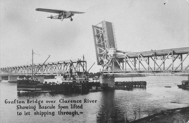
Grafton ( Bundjalung-Yugambeh: Gumbin Gir) is a city in the Northern Rivers region of the Australian state of New South Wales. It is located on the Clarence River, approximately by road north-northeast of the state capital Sydney. The closest major cities, Brisbane and the Gold Coast, are located across the border in South-East Queensland. At the 2021 census, Grafton had a population of 19,255. The city is the largest settlement and, with Maclean, the shared administrative centre of the Clarence Valley Council local government area, which is home to over 50,000 people in all. History Before European settlement, the Clarence River marked the border between the BundjalungTindale, Norman (1974) "Badjalang" in his ''Catalogue of A ... [...More Info...] [...Related Items...] OR: [Wikipedia] [Google] [Baidu] |
New South Wales
) , nickname = , image_map = New South Wales in Australia.svg , map_caption = Location of New South Wales in AustraliaCoordinates: , subdivision_type = Country , subdivision_name = Australia , established_title = Before federation , established_date = Colony of New South Wales , established_title2 = Establishment , established_date2 = 26 January 1788 , established_title3 = Responsible government , established_date3 = 6 June 1856 , established_title4 = Federation , established_date4 = 1 January 1901 , named_for = Wales , demonym = , capital = Sydney , largest_city = capital , coordinates = , admin_center = 128 local government areas , admin_center_type = Administration , leader_title1 = Monarch , leader_name1 = Charles III , leader_title2 = Governor , leader_name2 = Margaret Beazley , leader_title3 = Premier , leader_name3 = Dominic Perrottet (Liberal) , national_representation = Parliament of Australia , national_representation_type1 = Senat ... [...More Info...] [...Related Items...] OR: [Wikipedia] [Google] [Baidu] |
Australia
Australia, officially the Commonwealth of Australia, is a Sovereign state, sovereign country comprising the mainland of the Australia (continent), Australian continent, the island of Tasmania, and numerous List of islands of Australia, smaller islands. With an area of , Australia is the largest country by area in Oceania and the world's List of countries and dependencies by area, sixth-largest country. Australia is the oldest, flattest, and driest inhabited continent, with the least fertile soils. It is a Megadiverse countries, megadiverse country, and its size gives it a wide variety of landscapes and climates, with Deserts of Australia, deserts in the centre, tropical Forests of Australia, rainforests in the north-east, and List of mountains in Australia, mountain ranges in the south-east. The ancestors of Aboriginal Australians began arriving from south east Asia approximately Early human migrations#Nearby Oceania, 65,000 years ago, during the Last Glacial Period, last i ... [...More Info...] [...Related Items...] OR: [Wikipedia] [Google] [Baidu] |
North Coast Railway Line, New South Wales
The North Coast Line is the primary rail route in the Mid North Coast and Northern Rivers regions of New South Wales, Australia, and forms a major part of the Sydney–Brisbane rail corridor. The line begins at Maitland and ends at Roma Street railway station in Brisbane, although freight services terminate at the yard at Acacia Ridge on the outskirts of Brisbane. Along the way, the railway passes through the towns of Dungog, Gloucester, Wingham, Taree, Kendall, Wauchope, Kempsey, Macksville, Nambucca Heads, Urunga, Sawtell, Coffs Harbour, Grafton, Casino and Kyogle. After the standard gauge line ends at Acacia Ridge, it forms a dual gauge line into Brisbane, running alongside parts of the Beenleigh railway line. Since the Main Northern Line was closed north of Armidale in 1988, the North Coast line is now the only route between Sydney and Queensland. With the closure of former branches to Dorrigo (1972) and Murwillumbah (2004) there are no operating branches off th ... [...More Info...] [...Related Items...] OR: [Wikipedia] [Google] [Baidu] |
Census In Australia
The Census in Australia, officially the Census of Population and Housing, is the national census in Australia that occurs every five years. The census collects key demographic, social and economic data from all people in Australia on census night, including overseas visitors and residents of Australian external territories, only excluding foreign diplomats. The census is the largest and most significant statistical event in Australia and is run by the Australian Bureau of Statistics (ABS). Every person must complete the census, although some personal questions are not compulsory. The penalty for failing to complete the census after being directed to by the Australian Statistician is one federal penalty unit, or . The ''Australian Bureau of Statistics Act 1975'' and ''Census and Statistics Act 1905'' authorise the ABS to collect, store, and share anonymised data. The most recent census was held on 10 August 2021, with the data planned to be released starting from mid-2022. ... [...More Info...] [...Related Items...] OR: [Wikipedia] [Google] [Baidu] |
Towns In New South Wales
A town is a human settlement. Towns are generally larger than villages and smaller than cities, though the criteria to distinguish between them vary considerably in different parts of the world. Origin and use The word "town" shares an origin with the German word , the Dutch word , and the Old Norse . The original Proto-Germanic word, *''tūnan'', is thought to be an early borrowing from Proto-Celtic *''dūnom'' (cf. Old Irish , Welsh ). The original sense of the word in both Germanic and Celtic was that of a fortress or an enclosure. Cognates of ''town'' in many modern Germanic languages designate a fence or a hedge. In English and Dutch, the meaning of the word took on the sense of the space which these fences enclosed, and through which a track must run. In England, a town was a small community that could not afford or was not allowed to build walls or other larger fortifications, and built a palisade or stockade instead. In the Netherlands, this space was a garden, mor ... [...More Info...] [...Related Items...] OR: [Wikipedia] [Google] [Baidu] |
Northern Rivers
Northern Rivers is the most north-easterly region of the Australian state of New South Wales, located between north of the state capital, Sydney, and encompasses the catchments and fertile valleys of the Clarence, Richmond, and Tweed rivers. It extends from Tweed Heads in the north (adjacent to the Queensland border) to the southern extent of the Clarence river catchment which lies between Grafton and Coffs Harbour, and includes the main towns of Tweed Heads, Byron Bay, Ballina, Kyogle, Lismore, Casino and Grafton. At its most northern point, the region is south-southeast of the Queensland capital, Brisbane. As with all regions of New South Wales, it has no official status, although state government department offices and local governments in the area work together for purposes such as tourism, education, water catchment management and waste management. This area has a mild, sub-tropical climate. Major industries are agriculture, fisheries, public services (particularly h ... [...More Info...] [...Related Items...] OR: [Wikipedia] [Google] [Baidu] |


.jpg)
