|
Kuiseb
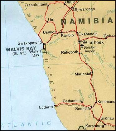
The Kuiseb River is an ephemeral river in western-central Namibia. Its source is in the Khomas Highland west of Windhoek. From there it flows westwards through the Namib-Naukluft National Park and the Namib desert to Walvis Bay. Several settlements of the Topnaar people are on the banks of the lower Kuiseb, for instance Homeb, Sandfontein, Rooibank, and Utuseb. Inflows of the Kuiseb are Gomab, Ojab, Chausib, Gaub, Koam, Nausgomab and Goagos. The Kuiseb's catchment area (including its tributaries) is estimated to be between 15,500 and . It has a mean run-off of roughly . Friedenau Dam, built in 1972, is on the river. In January 2005, for the first time in years, the Kuiseb flowed to the ocean. Between Naukluft and Namib the Kuiseb carved out a canyon in a barren and inaccessible area. During World War II the area around the Kuiseb Canyon served as a shelter for Henno Martin and Hermann Korn who moved there to wait the war out. Two books and a film were subsequently publ ... [...More Info...] [...Related Items...] OR: [Wikipedia] [Google] [Baidu] |
Walvis Bay
Walvis Bay ( en, lit. Whale Bay; af, Walvisbaai; ger, Walfischbucht or Walfischbai) is a city in Namibia and the name of the bay on which it lies. It is the second largest city in Namibia and the largest coastal city in the country. The city covers a total area of of land. The bay is a safe haven for sea vessels because of its natural deepwater harbour, protected by the Pelican Point sand spit, being the only natural harbour of any size along the country's coast. Being rich in plankton and marine life, these waters also drew large numbers of southern right whales, attracting whalers and fishing vessels. A succession of colonists developed the location and resources of this strategic harbour settlement. The harbour's value in relation to the sea route around the Cape of Good Hope had caught the attention of world powers since it was discovered by the outside world in 1485. This explains the complicated political status of Walvis Bay down the years. The town is situated j ... [...More Info...] [...Related Items...] OR: [Wikipedia] [Google] [Baidu] |
Topnaar People
The Topnaar people (ǂAonin) are a clan of the Nama people in Namibia. Their settlements are all situated on the Kuiseb River in the Erongo Region of central Namibia, the largest one is Utuseb. History Topnaars began settling in the area of Walvis Bay and along the Kuiseb River during the start of the 19th century. They first occupied the area at the mouth of the Swakop River, today the city of Swakopmund, and moved south beyond Walvis Bay to the Kuiseb mouth between 1820 and 1830. A small faction moved upriver to Sandfontein but was attacked and driven away by warriors of the Red Nation. They receded to Rooibank (''Scheppmannsdorf'' during Imperial Germany's colonial rule of South-West Africa). Missionary Heinrich Schmelen and Captain Amraal Lambert of the Kaiǀkhauan ( Khauas Nama) visited the Topnaar around 1824 or 1825 while searching for a hospitable place at the coast to improve logistics for the support of the missionaries in the hinterland. Culture and living cond ... [...More Info...] [...Related Items...] OR: [Wikipedia] [Google] [Baidu] |
Utuseb
Utuseb is a small settlement in the Erongo Region in western central Namibia. It is situated in the Namib Desert, approximately from Walvis Bay on the banks of Kuiseb River. Utuseb has approximately 700 inhabitants and belongs to the Walvis Bay Rural electoral constituency. The people living here belong to the ǂAonin (Southern Topnaar) community, a subtribe of the Nama people. History Topnaars began settling in the area of Walvis Bay and along the Kuiseb River during the start of the 19th century. They first occupied the area at the mouth of the Swakop River, today the city of Swakopmund, and moved south beyond Walvis Bay to the Kuiseb mouth between 1820 and 1830. A small faction moved upriver to Sandfontein but was attacked and driven away by warriors of the Red Nation. They receded to Rooibank (''Scheppmannsdorf'' during Imperial Germany's colonial rule of South-West Africa). Missionary Heinrich Schmelen and Captain Amraal Lambert of the Kaiǀkhauan ( Khauas Nama) visit ... [...More Info...] [...Related Items...] OR: [Wikipedia] [Google] [Baidu] |
Gobabeb
The Gobabeb Namib Research Institute, short: Gobabeb, is a centre for dry land training and research in Namibia. It is located in the Namib Desert, south-east of Walvis Bay. Gobabeb was founded by the Austrian entomologist Charles Koch in 1962. Since 1998 Gobabeb has been a joint venture between the ''Ministry of Environment and Tourism'' (MET) and the ''Desert Research Foundation Namibia'' (DRFN). Gobabeb conducts research in the fields of climate, ecology and geomorphology. It also tests, demonstrates and promotes appropriate technologies. By conducting training courses, Gobabeb aims to improve the public awareness and knowledge of dry land ecology and environmental issues. The station consists of permanent researchers, students, and interns, as well as short time visitors such as school and university groups, and tourists. Gobabeb also hosts film crews, journalists and artists. Station The Station is located south-east of Walvis Bay in Namibia's largest nature rese ... [...More Info...] [...Related Items...] OR: [Wikipedia] [Google] [Baidu] |
Henno Martin
Henno Martin (15 March 1910 – 7 January 1998) was a German professor of geology who, along with Hermann Korn, lived for two years in the Namib Desert to avoid internment during the Second World War. Personal life Martin was born in Freiburg, Germany on 15 March 1910. His studies at the universities of Bonn, Zürich, and Göttingen culminated in a Ph.D on "Post-Archean Tectonics in Southern Central Sweden". In 1935 he emigrated along with Korn to what was then South-West Africa (now Namibia) (a former German colony) and worked as a consulting geologist. Namibia was at that time administered by its neighbor, South Africa and in 1939 South Africa, following the United Kingdom, declared war on Germany. In 1940, fearing internment as enemy aliens by the South African government, Martin and Korn decided to flee into the Namib desert and to wait out the war in the remote and rugged Kuiseb Canyon. They returned to Windhoek in 1942 after Korn contracted beri-beri. They were not i ... [...More Info...] [...Related Items...] OR: [Wikipedia] [Google] [Baidu] |
Namib
The Namib ( ; pt, Namibe) is a coastal desert in Southern Africa. The name is of Khoekhoegowab origin and means "vast place". According to the broadest definition, the Namib stretches for more than along the Atlantic coasts of Angola, Namibia, and South Africa, extending southward from the Carunjamba River in Angola, through Namibia and to the Olifants River in Western Cape, South Africa. The Namib's northernmost portion, which extends from the Angola-Namibia border, is known as Moçâmedes Desert, while its southern portion approaches the neighboring Kalahari Desert. From the Atlantic coast eastward, the Namib gradually ascends in elevation, reaching up to inland to the foot of the Great Escarpment. Annual precipitation ranges from in the most arid regions to at the escarpment, making the Namib the only true desert in southern Africa. Having endured arid or semi-arid conditions for roughly 55–80 million years, the Namib may be the oldest desert in the world and conta ... [...More Info...] [...Related Items...] OR: [Wikipedia] [Google] [Baidu] |
Friedenau Dam
Friedenau Dam is a gravity concrete dam in Khomas Region, Namibia. Located southwest of Windhoek, it dams the Kuiseb River and provides water to nearby Matchless Mine. It has a capacity of and was completed in 1972, when the territory was occupied by South Africa South Africa, officially the Republic of South Africa (RSA), is the Southern Africa, southernmost country in Africa. It is bounded to the south by of coastline that stretch along the Atlantic Ocean, South Atlantic and Indian Oceans; to the .... at NamWater.com.na References Dams in Namibia Dams completed in 1972[...More Info...] [...Related Items...] OR: [Wikipedia] [Google] [Baidu] |
Namib-Naukluft National Park
The Namib-Naukluft Park is a national park in western Namibia, situated between the coast of the Atlantic Ocean and the edge of the Great Escarpment. It encompasses part of the Namib Desert (considered the world's oldest desert), the Naukluft mountain range, and the lagoon at Sandwich Harbour. The best-known area of the park and one of the main visitor attractions in Namibia is Sossusvlei, a clay pan surrounded by dunes, and Sesriem, a small canyon of the Tsauchab. The desert research station of Gobabeb is situated within the park. Location and description With an overall area of , the Namib-Naukluft National Park was at the time of its last expansion the largest game park in Africa and the fourth largest in the world. It consists of a strip of land on the Atlantic Ocean, including of sea, that extends roughly north-to-south from the Swakop River to the B4 road to Lüderitz. Wildlife A surprising collection of creatures survives in the hyper-arid region, including snake ... [...More Info...] [...Related Items...] OR: [Wikipedia] [Google] [Baidu] |
Swakop River
The Swakop River ( naq, Tsoaxaub) is a major river in western central Namibia. Its river source is in the Khomas Highland. From there it flows westwards through the town of Okahandja, the historic mission station at Gross Barmen, and the settlement of Otjimbingwe. It then crosses the Namib desert and reaches the Atlantic Ocean at Swakopmund (german: Mouth of the Swakop). The Swakop is an ephemeral river; its run-off is roughly 40 million cubic metres per annum. The Swakop River, along with its main tributary Khan, is one of the largest temporary water-bearing rivers in the dry western part of Namibia. It is long and has a large catchment area (including its tributaries). The name comes from the Khoekhoe languages of the Nama and Damara . means ‘excrement opening’ or ‘anus‘ while stands for the ‘contents of excrement.’ This name derives from the observation that the flow of large amounts of brownish sludge in the rain with it and discharges into the Atla ... [...More Info...] [...Related Items...] OR: [Wikipedia] [Google] [Baidu] |
Sand Dune
A dune is a landform composed of wind- or water-driven sand. It typically takes the form of a mound, ridge, or hill. An area with dunes is called a dune system or a dune complex. A large dune complex is called a dune field, while broad, flat regions covered with wind-swept sand or dunes with little or no vegetation are called '' ergs'' or ''sand seas''. Dunes occur in different shapes and sizes, but most kinds of dunes are longer on the stoss (upflow) side, where the sand is pushed up the dune, and have a shorter ''slip face'' in the lee side. The valley or trough between dunes is called a ''dune slack''. Dunes are most common in desert environments, where the lack of moisture hinders the growth of vegetation that would otherwise interfere with the development of dunes. However, sand deposits are not restricted to deserts, and dunes are also found along sea shores, along streams in semiarid climates, in areas of glacial outwash, and in other areas where poorly cemented ... [...More Info...] [...Related Items...] OR: [Wikipedia] [Google] [Baidu] |


