|
Kryoneri, Corinthia
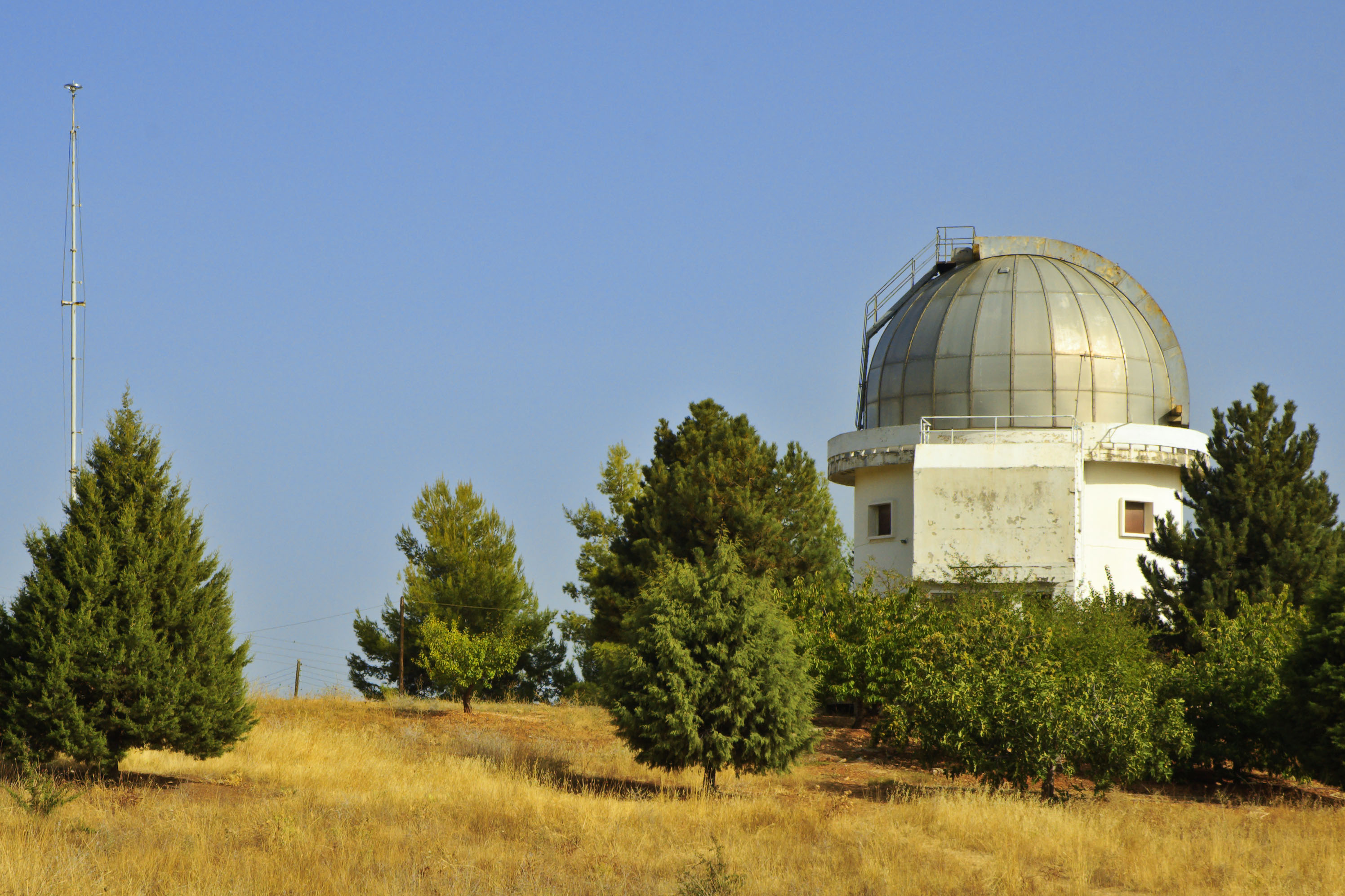
Kryoneri ( el, Κρυονέρι, before 1955: Μάτζανη - ''Matzani'') is a village in Corinthia regional unit, Greece. It is 42 km southwest of Corinth, built at 740 m height, in the slopes of Velisa mountain (part of Cyllene mountain). Kryoneri is part of the municipality of Sikyona. The village was flown through by a stream, tributary of Elisson River. Kryoneri has panoramic view towards northeast Corinthia until the coasts of Saronic and Corinthian gulf. Its population is 868 inhabitants according to 2011 census. History The first name of the settlement was Mergeni, which possibly means grass land. This name derived from the Franks who dominated the Peloponnese during the 13th and 14th centuries. The current name was given in 1954 which means a place with cold water. The village took part in the Greek War of Independence, where a chieftain from Kryoneri with the surname Stergiopoulos is mentioned. Historical population Places of interest The Kryoneri Astrono ... [...More Info...] [...Related Items...] OR: [Wikipedia] [Google] [Baidu] |
Peloponnese (region)
The Peloponnese Region ( el, Περιφέρεια Πελοποννήσου, translit=Periféria Peloponnísou, ) is a Modern regions of Greece, region in southern Greece. It borders Western Greece to the north and Attica (region), Attica to the north-east. The region has an area of about . It covers most of the Peloponnese peninsula, except for the northwestern subregions of Achaea and Elis (regional unit), Elis which belong to Western Greece and a small portion of the Argolis, Argolid peninsula that is part of Attica (region), Attica. Administration The Peloponnese Region was established in the 1987 administrative reform. With the 2011 Kallikratis plan, its powers and authority were redefined and extended. Along with the Western Greece and Ionian Islands (region), Ionian Islands regions, it is supervised by the Decentralized Administration of Peloponnese, Western Greece and the Ionian, Decentralized Administration of Peloponnese, Western Greece and the Ionian Islands based at P ... [...More Info...] [...Related Items...] OR: [Wikipedia] [Google] [Baidu] |
Principality Of Achaea
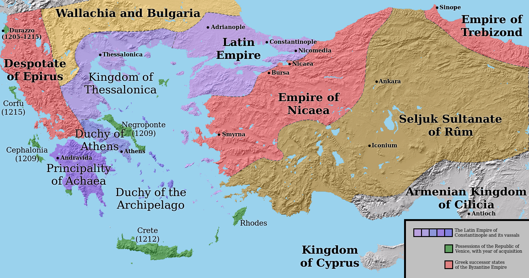
The Principality of Achaea () or Principality of Morea was one of the three vassal states of the Latin Empire, which replaced the Byzantine Empire after the capture of Constantinople during the Fourth Crusade. It became a vassal of the Kingdom of Thessalonica, along with the Duchy of Athens, until Thessalonica was captured by Theodore, the despot of Epirus, in 1224. After this, Achaea became for a while the dominant power in Greece. Foundation Achaea was founded in 1205 by William of Champlitte and Geoffrey I of Villehardouin, who undertook to conquer the Peloponnese on behalf of Boniface of Montferrat, King of Thessalonica. With a force of no more than 100 knights and 500 foot soldiers, they took Achaea and Elis, and after defeating the local Greeks in the Battle of the Olive Grove of Koundouros, became masters of the Morea. The victory was decisive, and after the battle all resistance from the locals was limited to a few forts that continued to hold out. The fort of Araklovon ... [...More Info...] [...Related Items...] OR: [Wikipedia] [Google] [Baidu] |
Mycenaean Era
Mycenaean Greece (or the Mycenaean civilization) was the last phase of the Bronze Age in Ancient Greece, spanning the period from approximately 1750 to 1050 BC.. It represents the first advanced and distinctively Greek civilization in mainland Greece with its palatial states, urban organization, works of art, and writing system.Lazaridis, Iosif et al.Genetic origins of the Minoans and Mycenaeans. ''Nature'', 2017Supplementary Information "The Mycenaeans", pp. 2–3).. The Mycenaeans were mainland Greek peoples who were likely stimulated by their contact with insular Minoan Crete and other Mediterranean cultures to develop a more sophisticated sociopolitical culture of their own. The most prominent site was Mycenae, after which the culture of this era is named. Other centers of power that emerged included Pylos, Tiryns, Midea in the Peloponnese, Orchomenos, Thebes, Athens in Central Greece and Iolcos in Thessaly. Mycenaean settlements also appeared in Epirus, Macedonia, on isl ... [...More Info...] [...Related Items...] OR: [Wikipedia] [Google] [Baidu] |
Katholikon
A ''katholikon'' or catholicon ( gr, καθολικόν) or ''sobor'' ( Slavonic: съборъ) refers to one of three things in the Eastern Orthodox Church: * The cathedral of a diocese. * The major church building (temple) of a monastery corresponding to a conventual church in Western Christianity. * A large church in a city at which all the faithful of the city gather to celebrate certain important feasts rather than go to their local parish church. The name derives from the fact that it is (usually) the largest church where all gather together to celebrate the major feast days of the liturgical year. In Russia, it is common for a katholikon to have a smaller church in the basement which can be more easily heated in the winter. A ''katholikon'' may have special architectural features in it, such as a ''kathedra'' (episcopal throne), or both an ''esonarthex'' (inner-narthex) and ''exonarthex'' (outer narthex), used for special services such as the Paschal vigil or a lity. Th ... [...More Info...] [...Related Items...] OR: [Wikipedia] [Google] [Baidu] |
Catoptric
Catoptrics (from grc-gre, κατοπτρικός ''katoptrikós'', "specular", from grc-gre, κάτοπτρον ''katoptron'' "mirror") deals with the phenomena of reflected light and image-forming optical systems using mirrors. A catoptric system is also called a ''catopter'' (''catoptre''). Ancient texts ''Catoptrics'' is the title of two texts from ancient Greece: *The Pseudo-Euclidean ''Catoptrics''. This book is attributed to Euclid, although the contents are a mixture of work dating from Euclid's time together with work which dates to the Roman period., accessed 31 January 2013 It has been argued that the book may have been compiled by the 4th century mathematician Theon of Alexandria. The book covers the mathematical theory of mirrors, particularly the images formed by plane and spherical concave mirrors. *Hero's ''Catoptrics''. Written by Hero of Alexandria, this work concerns the practical application of mirrors for visual effects. In the Middle Ages, this work was fa ... [...More Info...] [...Related Items...] OR: [Wikipedia] [Google] [Baidu] |
Chelmos Observatory
The Helmos or Chelmos Observatory ( el, Αστεροσκοπείο Χελμού) is an observatory located at the top of mount Chelmos, near Kalavryta, southern Greece. It is the largest research infrastructure of the National Observatory of Athens and IAASARS. The observatory was completed and first opened in 2001. Its main equipment is the Aristarchos 2.3 m Telescope, manufactured by German company Carl Zeiss AG. With the finance from the universities of Patras and Manchester. See also * List of astronomical observatories This is a list of astronomical observatories ordered by name, along with initial dates of operation (where an accurate date is available) and location. The list also includes a final year of operation for many observatories that are no longer in ... References Astronomical observatories in Greece Buildings and structures in Achaea {{Observatory-stub ... [...More Info...] [...Related Items...] OR: [Wikipedia] [Google] [Baidu] |
Kryoneri Astronomical Station
Kryoneri (Greek: Κρυονέρι meaning "cold water") may refer to numerous settlements in Greece: * Kryoneri, Achaea, a village in Achaea, part of the municipality Kalavryta * Kryoneri, Aetolia-Acarnania, a village in Aetolia-Acarnania, part of the municipal unit Chalkeia *Kryoneri, Attica, a community in East Attica *Kryoneri, Corinthia, a village in Corinthia, part of the municipality Sikyona * Kryoneri, Figaleia, a village in Elis, part of the municipality Figaleia *Kryoneri, Olympia, a village in Elis, part of the municipality Archaia Olympia * Kryoneri, Ioannina, a village in the Ioannina regional unit, part of the municipality Delvinaki *Kryoneri, Karditsa, a village in the Karditsa regional unit * Kryoneri, Kavala, a village in the Kavala regional unit, part of the municipal unit Filippoi * Kryoneri, Laconia, a village in Laconia, part of the municipality Oitylo * Kryoneri, Messenia, a village in Messenia, part of the municipality Aetos * Kryoneri, Rethymno, a village ... [...More Info...] [...Related Items...] OR: [Wikipedia] [Google] [Baidu] |
Observatory
An observatory is a location used for observing terrestrial, marine, or celestial events. Astronomy, climatology/meteorology, geophysical, oceanography and volcanology are examples of disciplines for which observatories have been constructed. Historically, observatories were as simple as containing an astronomical sextant (for measuring the distance between stars) or Stonehenge (which has some alignments on astronomical phenomena). Astronomical observatories Astronomical observatories are mainly divided into four categories: space-based, airborne, ground-based, and underground-based. Ground-based observatories Ground-based observatories, located on the surface of Earth, are used to make observations in the radio and visible light portions of the electromagnetic spectrum. Most optical telescopes are housed within a dome or similar structure, to protect the delicate instruments from the elements. Telescope domes have a slit or other opening in the roof that can be opened during ... [...More Info...] [...Related Items...] OR: [Wikipedia] [Google] [Baidu] |
Greek War Of Independence
The Greek War of Independence, also known as the Greek Revolution or the Greek Revolution of 1821, was a successful war of independence by Greek revolutionaries against the Ottoman Empire between 1821 and 1829. The Greeks were later assisted by the British Empire, Bourbon Restoration in France, Kingdom of France, and the Russian Empire, while the Ottomans were aided by their North African vassals, particularly the eyalet of Egypt Eyalet, Egypt. The war led to the formation of modern Greece. The revolution is Celebration of the Greek Revolution, celebrated by Greeks around the world as Greek Independence Day, independence day on 25 March. Greece, with the exception of the Ionian Islands, came under Ottoman rule in the 15th century, in the decades before and after the fall of Constantinople. During the following centuries, there were sporadic but unsuccessful Ottoman Greece#Uprisings before 1821, Greek uprisings against Ottoman rule. In 1814, a secret organization called Filiki Et ... [...More Info...] [...Related Items...] OR: [Wikipedia] [Google] [Baidu] |
Frankokratia
The ''Frankokratia'' ( el, Φραγκοκρατία, la, Francocratia, sometimes anglicized as Francocracy, "rule of the Franks"), also known as ''Latinokratia'' ( el, Λατινοκρατία, la, Latinocratia, "rule of the Latins") and, for the Venetian domains, ''Venetokratia'' or ''Enetokratia'' ( el, Βενετοκρατία or Ενετοκρατία, la, Venetocratia, "rule of the Venetians"), was the period in Greek history after the Fourth Crusade (1204), when a number of primarily French and Italian states were established by the ''Partitio terrarum imperii Romaniae'' on the territory of the dissolved Byzantine Empire. The terms Frankokratia and Latinokratia derive from the name given by the Orthodox Greeks to the Western French and Italians who originated from territories that once belonged to the Frankish Empire. The Frankish Empire being the political entity which ruled much of the former Western Roman Empire after the collapse of Roman authority and power. ... [...More Info...] [...Related Items...] OR: [Wikipedia] [Google] [Baidu] |
Corinthia
Corinthia ( el, Κορινθία ''Korinthía'') is one of the regional units of Greece. It is part of the region of Peloponnese. It is situated around the city of Corinth, in the north-eastern part of the Peloponnese peninsula. Geography Corinthia borders on Achaea to the west and southwest, the Gulf of Corinth and Attica to the north, the Saronic Gulf to the east, Argolis to the south and Arcadia to the southwest. The Corinth Canal, carrying ship traffic between the Ionian and the Aegean seas, is about east of Corinth, cutting through the Isthmus of Corinth. Corinthia is increasingly seen as part of the wider metropolitan area of Athens, with municipalities, such as Agioi Theodoroi in the easternmost part of the regional unit, being considered suburbs of Athens. The area around Corinth and the western Saronic including the southeastern part are made up of fault lines including the Corinth Fault, the Poseidon Fault and a fault running from Perahcora to Agioi Theodoroi. M ... [...More Info...] [...Related Items...] OR: [Wikipedia] [Google] [Baidu] |
Corinthian Gulf
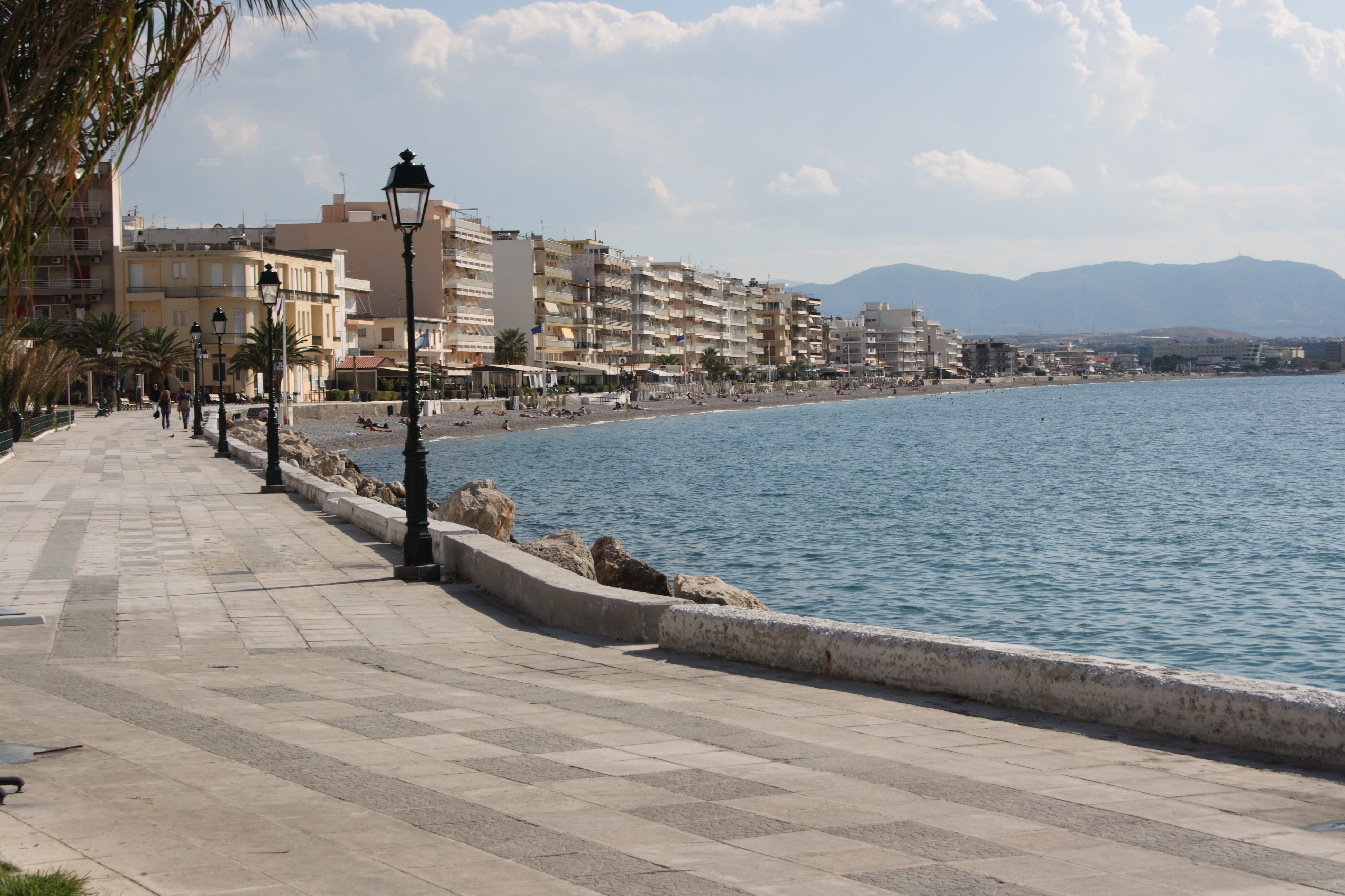
The Gulf of Corinth or the Corinthian Gulf ( el, Κορινθιακός Kόλπος, ''Korinthiakόs Kόlpos'', ) is a deep inlet of the Ionian Sea, separating the Peloponnese from western mainland Greece. It is bounded in the east by the Isthmus of Corinth which includes the shipping-designed Corinth Canal and in the west by the Strait of Rion which widens into the shorter Gulf of Patras (part of the Ionian Sea) and of which the narrowest point is crossed since 2004 by the Rio–Antirrio bridge. The gulf is bordered by the large administrative divisions (regional units): Aetolia-Acarnania and Phocis in the north, Boeotia in the northeast, Attica in the east, Corinthia in the southeast and south and Achaea in the southwest. The gulf is in tectonic movement comparable to movement in parts of Iceland and Turkey, growing by per year. In the Middle Ages, the gulf was known as the Gulf of Lepanto (the Italian form of Naupactus). Shipping routes between the Greek commercial port ... [...More Info...] [...Related Items...] OR: [Wikipedia] [Google] [Baidu] |

.jpg)


