|
Kreis Bergen
Kreis Bergen (district of Bergen) was a ''Landkreis, Kreis'' on the island of Rügen in the district of Bezirk Rostock in East Germany from 1952 to 1955. History After the end of the Second World War the Landkreis Rügen, shire county of Rügen (''Landkreis Rügen''), which covered the island of Rügen, came under the Soviet Zone of Occupation and was incorporated into the state of Land Mecklenburg, Mecklenburg. On 25 July 1952 there was a comprehensive land reform in East Germany, in which the states lost their importance and new provinces called ''Administrative divisions of East Germany, Bezirke'' were formed. Out of the territory of the old county of Rügen the town new counties of Bergen and Kreis Putbus, Putbus were formed. Because the division of the island of Rügen into two counties soon proved pointless, the counties of Bergen and Putbus were reunited on 1 January 1956 into the Kreis Rügen, county of Rügen. Transport Kreis Bergen was joined to East Germany's ... [...More Info...] [...Related Items...] OR: [Wikipedia] [Google] [Baidu] |
Administrative Divisions Of East Germany
The administrative divisions of the German Democratic Republic (commonly referred to as East Germany) were constituted in two different forms during the country's history. The GDR first retained the traditional German division into federated states called ''Länder'', but in 1952 they were replaced with districts called ''Bezirke''. Immediately before German reunification in 1990, the ''Länder'' were restored, but they were not effectively reconstituted until after reunification had completed. Division into ''Länder'' General background In May 1945, following its defeat in World War II, Germany was occupied by the United States, Britain, France and the Soviet Union. All four occupation powers reorganised the territories by recreating the ''Länder'' (states), the constituting parts of federal Germany. The state of Prussia, whose provinces extended to all four zones and covered two thirds of Germany, was abolished in 1947. Special conditions were assigned to Berlin, which t ... [...More Info...] [...Related Items...] OR: [Wikipedia] [Google] [Baidu] |
Stralsund–Sassnitz Railway
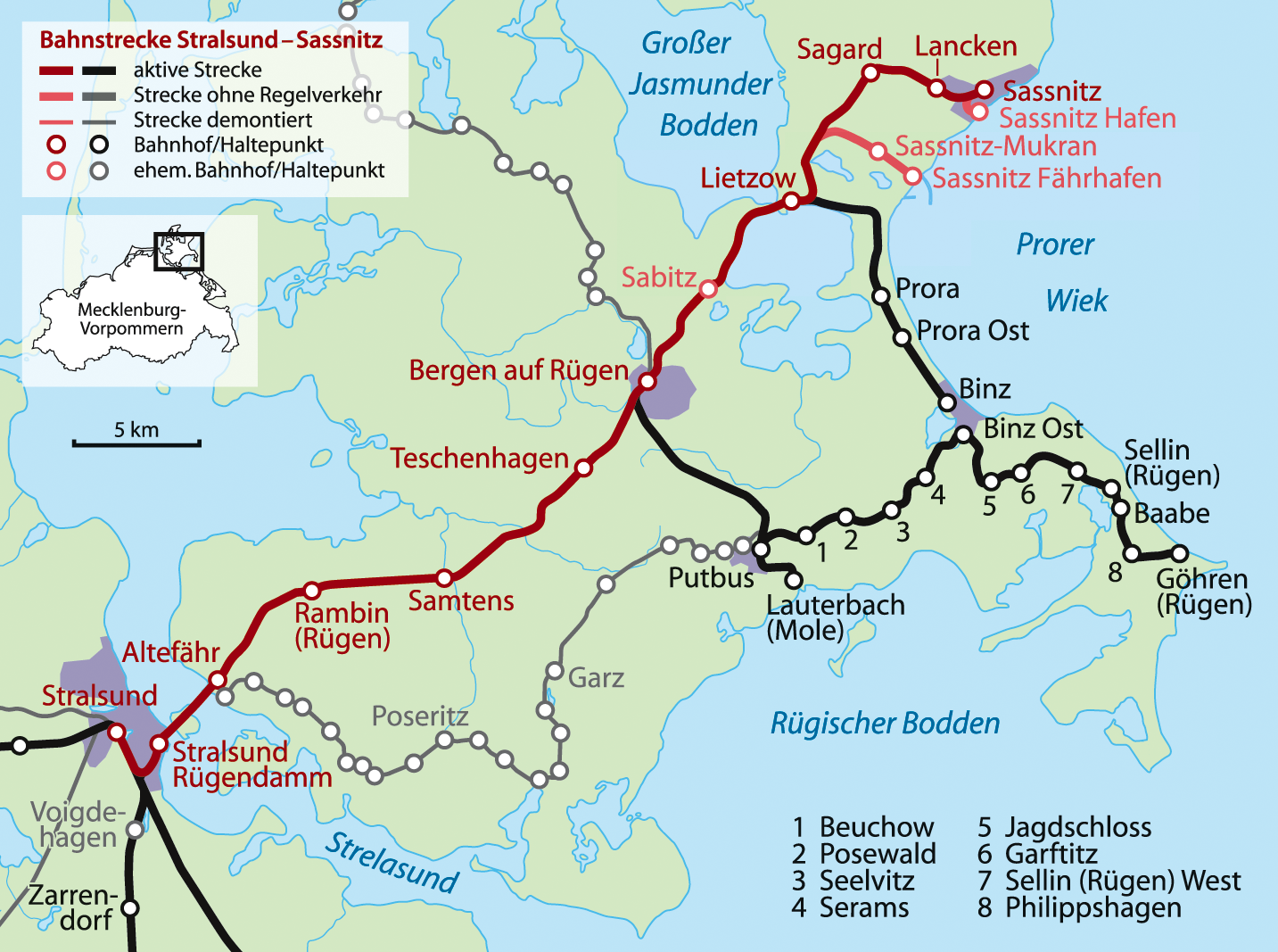
Stralsund–Sassnitz railway is a railway line, most of which is located on the German island of Rügen and which is its most important railway. The line is the northernmost German section of the route from Berlin to Stockholm. Course The line starts at Stralsund Central Station. Even before it leaves the station yard, it branches off from the Angermünde-Stralsund Railway and swings away to the northeast. A link curve to the south enables trains to run straight into Stralsund from the island of Rügen without having to change direction. After passing the branch to the port of Stralsund (''Stralsunder Hafen''), it reaches the Rügen Causeway (''Rügendamm''). Shortly thereafter, the line passes over the 133-metre-long Ziegelgraben Bridge - a bascule bridge - to the island of Dänholm off the Strelasund. Then it goes over the 540-metre-long Strelasund Bridge to the island of Rügen. The Ziegelgraben Bridge, the Strelasund Bridge and the embankments on the mainland and Dänho ... [...More Info...] [...Related Items...] OR: [Wikipedia] [Google] [Baidu] |
Buschvitz
Buschvitz is a municipality in the Vorpommern-Rügen district, in Mecklenburg-Vorpommern, Germany Germany,, officially the Federal Republic of Germany, is a country in Central Europe. It is the second most populous country in Europe after Russia, and the most populous member state of the European Union. Germany is situated betwe .... References External links Official website of Buschvitz Towns and villages on Rügen {{VorpommernRügen-geo-stub ... [...More Info...] [...Related Items...] OR: [Wikipedia] [Google] [Baidu] |
Breege
Breege is a municipality in the Vorpommern-Rügen district, in Mecklenburg-Vorpommern, Germany. The municipality consists of the villages Breege, Juliusruh Juliusruh is a village on the northern coast of the island of Rügen in northeastern Germany. Juliusruh is part of the municipality of Breege. Juliusruh and Breege combined have 821 inhabitants in an area of 15,99 km² (approx. 6 sq miles). ..., Kammin, Lobkevitz and Schmantevitz. References External links * *Official website of Breege Towns and villages on Rügen Wittow {{VorpommernRügen-geo-stub ... [...More Info...] [...Related Items...] OR: [Wikipedia] [Google] [Baidu] |
Altenkirchen (Rügen)
Altenkirchen () is a town in Rhineland-Palatinate, Germany, capital of the Altenkirchen (district), district of Altenkirchen. It is located approximately 40 km east of Bonn and 50 km north of Koblenz. Altenkirchen is the seat of the ''Verbandsgemeinde'' ("collective municipality") Altenkirchen-Flammersfeld. Population development Geography *Lahrer Herrlichkeit, a landscape region in the collective municipality of Verbandsgemeinde Flammersfeld, Flammersfeld Notable people * Dirk Adorf (born 1969), race car driver * Sabine Bätzing-Lichtenthäler (born 1975), politician (SPD) * Dittmar Hahn (born 1943), former judge of the Federal Administrative Court (Germany), Federal Administrative Court * Claus Koch (born 1953), jazz musician * Ernst Lindemann (1894–1941), an officer of the Imperial German Navy, Imperial Navy and later the Navy commander of the battleship '' German battleship Bismarck, Bismarck '' * Hermann Heinrich Traut (born 1866), librarian * Marie Gülich ... [...More Info...] [...Related Items...] OR: [Wikipedia] [Google] [Baidu] |
Wittow
Wittow is the northernmost peninsula of the island of Rügen. Wittow was a separate island until the High Middle Ages, but since then has been connected to the Jasmund peninsula of Rügen by the Schaabe spit. Wittow is most famous for Cape Arkona Cape Arkona () is a 45-metre (150-foot) high cape on the island of Rügen in Mecklenburg-Vorpommern, Germany. It forms the tip of the Wittow peninsula, just a few kilometres north of the Jasmund National Park. The protected landscape of Cape Arko ... hosting the remnants of a former Rani temple burgh. It was also known as 'Wittmund' or 'Witmond' in the 1700s. Geography of Rügen Peninsulas of Mecklenburg-Western Pomerania {{VorpommernRügen-geo-stub ... [...More Info...] [...Related Items...] OR: [Wikipedia] [Google] [Baidu] |
Schaabe
The Schaabe is a bar, almost twelve kilometres long, on the German Baltic Sea island of Rügen. It joins the peninsulas of Jasmund and Wittow. Washed up and shaped by the sea, it forms a sickle-shaped shoreline on the bay of Tromper Wiek and separates the lagoons of the Großer Jasmunder Bodden and ''Breeger Bodden'' from the Baltic. The fine, washed up sand forms a giant natural bathing bay, that is bordered by the villages of Glowe and Juliusruh (a village in the municipality of Breege). Unlike the second largest bar on the island of Rügen, the Schmale Heide between Jasmund and the Granitz, which is dominated by the construction of the former Nazi "Strength Through Joy" resort of Prora and decades of military use and its associated infrastructure, the Schaabe between Glowe and Juliusruh is undeveloped apart from a managed forest, the only through road and its accompanying cycle path. Formation The Schaabe began to form about 4,500 years ago, when Rügen was still an is ... [...More Info...] [...Related Items...] OR: [Wikipedia] [Google] [Baidu] |
Jasmund
Jasmund is a peninsula of the island of Rügen in Mecklenburg-Vorpommern, Germany. It is connected to the Wittow peninsula and to the Muttland main section of Rügen by the narrow land bridges Schaabe and Schmale Heide, respectively. Sassnitz, Sagard and the Mukran international ferry terminal are on Jasmund. Jasmund is also famous for the Rügen Chalk cliffs within the Jasmund National Park The Jasmund National Park (German: ''Nationalpark Jasmund'') is a nature reserve on the Jasmund peninsula, in the northeast of Rügen island in Mecklenburg-Vorpommern, Germany. It is famous for containing the largest chalk cliffs in Germany, the ..., a nature reserve in the northeast of Rügen island. References Peninsulas of Mecklenburg-Western Pomerania Geography of Rügen {{VorpommernRügen-geo-stub ... [...More Info...] [...Related Items...] OR: [Wikipedia] [Google] [Baidu] |
Bug (Rügen)
Bug is the name both of the westernmost tongue of land (''Landzunge'') on the peninsula of Wittow on the German island of Rügen, as well as the name of the former village there. Bug begins south of the village of Dranske and belongs territorially to that municipality. Origin of the name One theory suggests the name ''Bug'' goes back to a landowner, Baronet Antonius de Buge, first mentioned in 1284. Another suggests that the word Bug is derived from the German word ''Biegung'' = "bend". It is also possible that it may have come from a Slavic word ''bug'' = beech. Geography The peninsula of Bug runs in a southwesterly direction from the village of Dranske for a distance of 8 km and has an area of 500 ha. It is only 55 metres wide at its narrowest point in the northeast; in the southwest its maximum width measures about 1,500 metres. To the west of the Bug is the Baltic Sea with the northern part of the island of Hiddensee. To the southwest is the lagoon of Vitte ... [...More Info...] [...Related Items...] OR: [Wikipedia] [Google] [Baidu] |
Ummanz
The island of Ummanz lies in the Baltic Sea, off the west coast of the island of Rügen, and belongs, like the latter, to the county of Vorpommern-Rügen in the German state of Mecklenburg-Western Pomerania. Ummanz is around 20 square kilometres in area and thus, after Rügen, the second largest island in the former county of Rügen. It is part of the Western Pomerania Lagoon Area National Park. The island is bounded to the west and northwest by the Schaproder Bodden, to the north, by the inlet of Udarser Wiek, to the east by the lake of ''Koselower See'' and the ''Breite'' and to the south by the Kubitzer Bodden. The island of Ummanz is very flat; its highest point lying just 3 metres above sea level (NN). Since 1901 the island has been linked to the island of Rügen by a 250-metre-long bridge. The largest settlement on the island is the parish village of Waase; other villages are Haide, Markow, Suhrendorf, Freesenort, Tankow and Wusse. Together with several villages on Rüge ... [...More Info...] [...Related Items...] OR: [Wikipedia] [Google] [Baidu] |
Hiddensee
Hiddensee () is a car-free island in the Baltic Sea, located west of Germany's largest island, Rügen, on the German coast. The island has about 1,000 inhabitants. It was a holiday destination for East German tourists during German Democratic Republic (GDR) times, and continues to attract tourists today. It is the location of the University of Greifswald's ornithological station. Gerhart Hauptmann and Walter Felsenstein are buried there. Name The name ''Hedinsey'' surfaces as early as the ''Prose Edda'' and the ''Gesta Danorum'' written by Saxo Grammaticus and means "Island of Hedin". The legendary Norwegian king, Hedin, was supposed to have fought here for a woman or even just for gold. Under Danish rule the name ''Hedins-Oe'' ("Hedin's Island") was common. Even in 1880 the island was shown in German maps as ''Hiddensjö'' and, in 1929, in German holiday guides as ''Hiddensöe''. Its full Germanization to ''Hiddensee'' is thus relatively recent. Geography Hiddensee is ... [...More Info...] [...Related Items...] OR: [Wikipedia] [Google] [Baidu] |


.png)

