|
Koggala
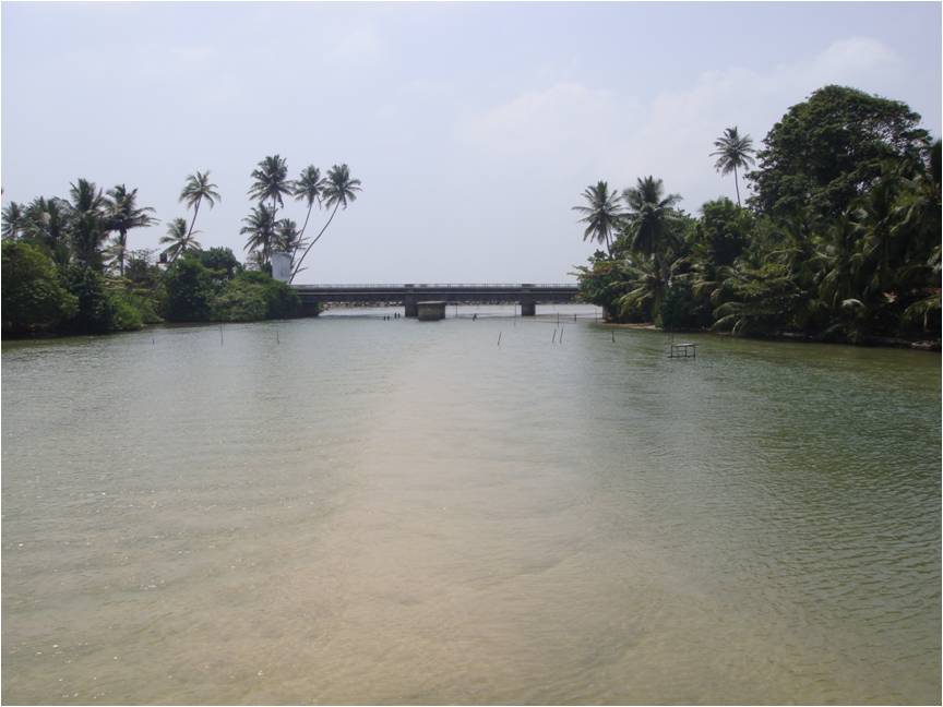
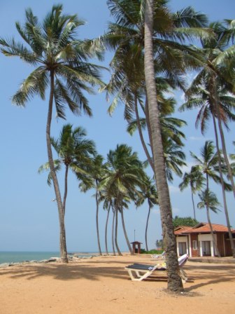
Koggala ( si, කොග්ගල, translit=Koggala; ta, கொக்கலை, translit=Kokkalai) is a small coastal town, situated at the edge of a lagoon on the south coast of Sri Lanka, located in Galle District, Southern Province, Sri Lanka, governed by an Urban Council. Koggala is bounded on one side by a reef, and on the other by a large lake, Koggala Lake, into which the numerous tributaries of the Koggala Oya drain. It is approximately south of Colombo and is situated at an elevation of above the sea level. History Koggala has one of the longest beaches in Sri Lanka, and is located in close proximity to the popular tourist resort of Unawatuna, Koggala in comparison is relatively uncluttered as a tourist destination and mostly unexplored. Koggala was significantly affected by the tsunami caused by the 2004 Indian Ocean earthquake, where the waters measured high. It is the birthplace of noted Sri Lankan author Martin Wickramasinghe and there is a museum, Martin Wickram ... [...More Info...] [...Related Items...] OR: [Wikipedia] [Google] [Baidu] |
Koggala Lake
Koggala Lagoon ( si, කොග්ගල කලපුව ''Koggala Kalapuwa'') is a coastal body of water located in Galle District, Southern Sri Lanka. It is situated near the town of Koggala and adjacent to the southern coast, about south of Colombo. The lagoon is embellished with eight ecologically rich small islands. Features and location The lagoon has a surface area of approximately measuring in length and in width. The water depth ranges from to . The lagoon is largely rain fed and a number of streams are connected to it. Warabokka-ela stream (Koggala-oya) that enters the lagoon from the north-west is the main freshwater supply.Gunaratne, G.L.; Norio, Tanaka; Amarasekara, P.; Priyadarshana, T.; Manatunge, J. 2010. Restoration of Koggala lagoon: Modeling approach in evaluating lagoon water budget and flow characteristics. Journal of Environmental Sciences 22(6):813-819. Kerena anicut, which was constructed combining two streams, Mudiyansege-ela stream and Thithagalla-el ... [...More Info...] [...Related Items...] OR: [Wikipedia] [Google] [Baidu] |
Koggala Airport
Koggala Airport ( Sinhala: කොග්ගල ගුවන්තොටුපළ ''Koggala Guwanthotupala'') in Sri Lanka was originally a Royal Air Force (RAF) Station RAF Koggala. It is now the SLAF Koggala, used for domestic flights and for military purposes. History Prior to the Second World War, the lake at Koggala was used for seaplanes. After the Japanese occupation of the Malay Peninsula in 1942, the RAF needed a new seaplane base. In March 1942 RAF Koggala consisted of forty people, one PBY Catalina flying boat and no outlet to the sea from the lagoon. Within a month more than a hundred more personnel arrived (mostly from Singapore) and construction began on establishing the water runway and the requirements for a large flying boat base. (slip ways to take boats out of the water, cover etc.) and by the end of 1942 there were over 800 personnel at the base. It became the largest flying-boat base in the east. The RAF flew Consolidated PBY Catalinas and Short Sunderla ... [...More Info...] [...Related Items...] OR: [Wikipedia] [Google] [Baidu] |
Martin Wickramasinghe
Lama Hewage Don Martin Wickramasinghe, (commonly known as Martin Wickramasinghe) ( si, මාර්ටින් වික්රමසිංහ) (29 May 1890 – 23 July 1976) was a Sri Lankan journalist and author. His books have been translated into several languages. Wickramasinghe is often acclaimed as the father of modern Sinhala literature.Martin Wickramasinghe: Literary colossus of the last Century by Dr. W. A. Abeysinghe (Island) Accessed 2016-09-27Biographical sketch of Martin Wickramasinghe by Dr. Ranga Wickramasinghe (Daily News) Accessed 2016-09 ... [...More Info...] [...Related Items...] OR: [Wikipedia] [Google] [Baidu] |
List Of Beaches In Sri Lanka ...
The following is a list of beaches in Sri Lanka, an island nation south of India in the Indian Ocean. See also *Sri Lanka *List of beaches References {{Geography of Sri Lanka * Sri Lanka Beaches Beaches A beach is a landform alongside a body of water which consists of loose particles. The particles composing a beach are typically made from rock, such as sand, gravel, shingle, pebbles, etc., or biological sources, such as mollusc shells ... [...More Info...] [...Related Items...] OR: [Wikipedia] [Google] [Baidu] |
Koggala Railway Station
Koggola railway station ( si, කොග්ගල දුම්රිය ස්ථානය) is a railway station on the coastal railway line of Sri Lanka. The station is situated between Kathaluwa and Habaraduwa railway stations and is along the railway line from the Colombo Fort Railway Station Fort railway station is a major rail hub in Colombo, Sri Lanka. The station is served by Sri Lanka Railways, with many inter-city and commuter trains entering each day. Fort Station is the main rail gateway to central Colombo; it is the terminus .... The trains run multiple services to Colombo Fort and Matara daily. Continuity References Railway stations on the Coastal Line Railway stations in Galle District {{SriLanka-railstation-stub ... [...More Info...] [...Related Items...] OR: [Wikipedia] [Google] [Baidu] |
Galle District
Galle ( si, ගාල්ල දිස්ත්රික්කය ''gālla distrikkaya''; ta, காலி மாவட்டம் ''Kāli māvattam'') is a district in Southern Province, Sri Lanka. It is one of 25 districts of Sri Lanka, the second level administrative division of the country. The district is administered by a District Secretariat headed by a District Secretary (previously known as a Government Agent) appointed by the central government of Sri Lanka. Geological background Its area is : is water and is land. Galle District bounded on the north by Benthara river, south and west by the Indian Ocean and east by Matara and Ratnapura districts. The topography of Galle District is very much dissent. The climatic condition of Hiniduma Patthuwa is very similar to the central hill country of Sri Lanka. This area consists of rainforests, which is the water catchment area for most of the rivers and lakes flows across Galle District. Sinharaja Forest Reserve is o ... [...More Info...] [...Related Items...] OR: [Wikipedia] [Google] [Baidu] |
A2 Highway (Sri Lanka)
The A 2 is an A-Grade road in Sri Lanka. It connects Colombo and Wellawaya via Kalutara, Galle, Matara and Hambantota. Route Colombo to Galle The west-coast portion of the highway consists of the Galle Road. Within Colombo, the A2 serves as a north–south backbone to the city. It is split into two one-way streets from Colombo Fort to Wellawatte, in order to ease traffic flow. The highway passes through Wellawatte, Ratmalana, Kalutara, Wadduwa, Maggona, Beruwala, Bentota, Panadura, Kosgoda, Ambalangoda, Hikkaduwa, and Galle. At Galle, the highway runs through the city centre before continuing towards Hambantota. Galle to Hambantota From Galle, the highway continues east along the south coast towards Ahangama. It passes Unawatuna, Koggala, Ahangama and Weligama, before arriving at Matara. At Matara, it passes the University of Ruhuna. The highway continues towards Dikwella, Tangalle, Ambalantota, and Hambantota. To cross the artificial harbour at Hambantota, ... [...More Info...] [...Related Items...] OR: [Wikipedia] [Google] [Baidu] |
Queen Victoria
Victoria (Alexandrina Victoria; 24 May 1819 – 22 January 1901) was Queen of the United Kingdom of Great Britain and Ireland from 20 June 1837 until Death and state funeral of Queen Victoria, her death in 1901. Her reign of 63 years and 216 days was longer than that of List of monarchs in Britain by length of reign, any previous British monarch and is known as the Victorian era. It was a period of industrial, political, scientific, and military change within the United Kingdom, and was marked by a great expansion of the British Empire. In 1876, the British Parliament voted to grant her the additional title of Empress of India. Victoria was the daughter of Prince Edward, Duke of Kent and Strathearn (the fourth son of King George III), and Princess Victoria of Saxe-Coburg-Saalfeld. After the deaths of her father and grandfather in 1820, she was Kensington System, raised under close supervision by her mother and her comptroller, John Conroy. She inherited the throne aged 18 af ... [...More Info...] [...Related Items...] OR: [Wikipedia] [Google] [Baidu] |
Populated Places In Galle District
Population typically refers to the number of people in a single area, whether it be a city or town, region, country, continent, or the world. Governments typically quantify the size of the resident population within their jurisdiction using a census, a process of collecting, analysing, compiling, and publishing data regarding a population. Perspectives of various disciplines Social sciences In sociology and population geography, population refers to a group of human beings with some predefined criterion in common, such as location, race, ethnicity, nationality, or religion. Demography is a social science which entails the statistical study of populations. Ecology In ecology, a population is a group of organisms of the same species who inhabit the same particular geographical area and are capable of interbreeding. The area of a sexual population is the area where inter-breeding is possible between any pair within the area and more probable than cross-breeding with in ... [...More Info...] [...Related Items...] OR: [Wikipedia] [Google] [Baidu] |
List Of Towns In Galle Province, Sri Lanka
A ''list'' is any set of items in a row. List or lists may also refer to: People * List (surname) Organizations * List College, an undergraduate division of the Jewish Theological Seminary of America * SC Germania List, German rugby union club Other uses * Angle of list, the leaning to either port or starboard of a ship * List (information), an ordered collection of pieces of information ** List (abstract data type), a method to organize data in computer science * List on Sylt, previously called List, the northernmost village in Germany, on the island of Sylt * ''List'', an alternative term for ''roll'' in flight dynamics * To ''list'' a building, etc., in the UK it means to designate it a listed building that may not be altered without permission * Lists (jousting), the barriers used to designate the tournament area where medieval knights jousted * ''The Book of Lists'', an American series of books with unusual lists See also * The List (other) * Listing (di ... [...More Info...] [...Related Items...] OR: [Wikipedia] [Google] [Baidu] |
Postal Code
A postal code (also known locally in various English-speaking countries throughout the world as a postcode, post code, PIN or ZIP Code) is a series of letters or digits or both, sometimes including spaces or punctuation, included in a postal address for the purpose of sorting mail. the Universal Postal Union lists 160 countries which require the use of a postal code. Although postal codes are usually assigned to geographical areas, special codes are sometimes assigned to individual addresses or to institutions that receive large volumes of mail, such as government agencies and large commercial companies. One example is the French CEDEX system. Terms There are a number of synonyms for postal code; some are country-specific; * CAP: The standard term in Italy; CAP is an acronym for ''codice di avviamento postale'' (postal expedition code). * CEP: The standard term in Brazil; CEP is an acronym for ''código de endereçamento postal'' (postal addressing code). * Eircode: Th ... [...More Info...] [...Related Items...] OR: [Wikipedia] [Google] [Baidu] |
Area Code
A telephone numbering plan is a type of numbering scheme used in telecommunication to assign telephone numbers to subscriber telephones or other telephony endpoints. Telephone numbers are the addresses of participants in a telephone network, reachable by a system of destination code routing. Telephone numbering plans are defined in each of the administrative regions of the public switched telephone network (PSTN) and in private telephone networks. For public numbering systems, geographic location typically plays a role in the sequence of numbers assigned to each telephone subscriber. Many numbering plan administrators subdivide their territory of service into geographic regions designated by a prefix, often called an area code or city code, which is a set of digits forming the most-significant part of the dialing sequence to reach a telephone subscriber. Numbering plans may follow a variety of design strategies which have often arisen from the historical evolution of individual ... [...More Info...] [...Related Items...] OR: [Wikipedia] [Google] [Baidu] |

.jpg)


.jpg)


