|
Knight Street
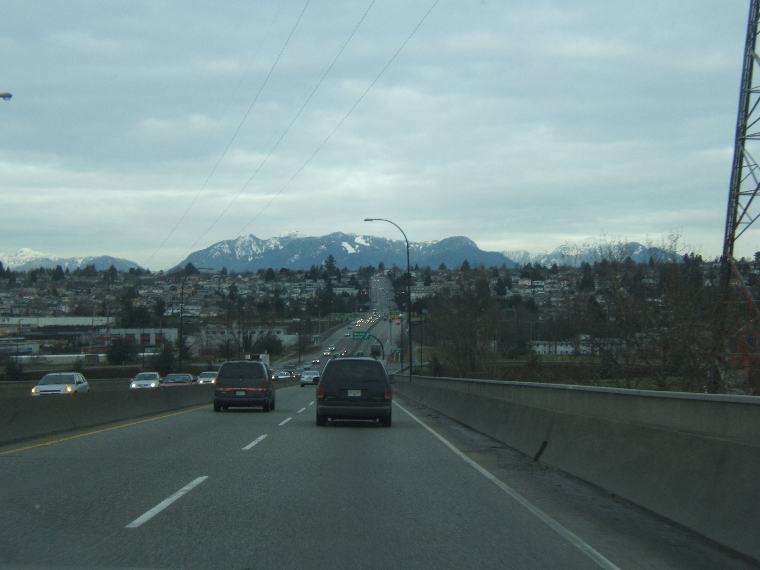
Knight Street is a major north-south roadway in Vancouver and Richmond, British Columbia, Canada. It is a four-to-six lane freeway from Westminster Highway in Richmond to Marine Drive in Vancouver, thus serving as an alternate way to exit Vancouver southbound, rather than the Granville Street/ Oak Street corridor. Upon entering Vancouver, Knight Street provides major access routes to East Vancouver; at 14th Avenue, the road turns into Clark Drive, and runs northbound until it reaches the Port of Vancouver at Burrard Inlet. It is the busiest truck route in Vancouver, City of Vancouver, March 2003. Accessed online January 20, 2011. and a key link between Vancouver and its neighbours to the south. The freeway section of Knight Street crosses the |
TransLink (British Columbia)
TransLink, formally the South Coast British Columbia Transportation Authority, is the statutory authority responsible for the regional transportation network of Metro Vancouver in British Columbia, Canada, including public transport, major roads and bridges. Its main operating facilities are located in the city of New Westminster. TransLink was created in 1998 as the Greater Vancouver Transportation Authority (GVTA) and was fully implemented in April 1999 by the Government of British Columbia to replace BC Transit in the Greater Vancouver Regional District and assume many transportation responsibilities previously held by the provincial government. TransLink is responsible for various modes of transportation in the Metro Vancouver region as well as the West Coast Express, which extends into the Fraser Valley Regional District (FVRD). On November 29, 2007, the province of British Columbia approved legislation changing the governance structure and official name of the organizatio ... [...More Info...] [...Related Items...] OR: [Wikipedia] [Google] [Baidu] |
Fraser River
The Fraser River is the longest river within British Columbia, Canada, rising at Fraser Pass near Blackrock Mountain in the Rocky Mountains and flowing for , into the Strait of Georgia just south of the City of Vancouver. The river's annual discharge at its mouth is or , and it discharges 20 million tons of sediment into the ocean. Naming The river is named after Simon Fraser, who led an expedition in 1808 on behalf of the North West Company from the site of present-day Prince George almost to the mouth of the river. The river's name in the Halqemeylem (Upriver Halkomelem) language is , often seen archaically as Staulo, and has been adopted by the Halkomelem-speaking peoples of the Lower Mainland as their collective name, . The river's name in the Dakelh language is . The ''Tsilhqot'in'' name for the river, not dissimilar to the ''Dakelh'' name, is , meaning Sturgeon ''()'' River ''()''. Course The Fraser drains a area. Its source is a dripping spring at Fraser Pas ... [...More Info...] [...Related Items...] OR: [Wikipedia] [Google] [Baidu] |
Streets In Vancouver
Streets is the plural of street, a type of road. Streets or The Streets may also refer to: Music * Streets (band), a rock band fronted by Kansas vocalist Steve Walsh * ''Streets'' (punk album), a 1977 compilation album of various early UK punk bands * '' Streets...'', a 1975 album by Ralph McTell * '' Streets: A Rock Opera'', a 1991 album by Savatage * "Streets" (song) by Doja Cat, from the album ''Hot Pink'' (2019) * "Streets", a song by Avenged Sevenfold from the album ''Sounding the Seventh Trumpet'' (2001) * The Streets, alias of Mike Skinner, a British rapper * "The Streets" (song) by WC featuring Snoop Dogg and Nate Dogg, from the album ''Ghetto Heisman'' (2002) Other uses * ''Streets'' (film), a 1990 American horror film * Streets (ice cream), an Australian ice cream brand owned by Unilever * Streets (solitaire), a variant of the solitaire game Napoleon at St Helena * Tai Streets (born 1977), American football player * Will Streets (1886–1916), English soldier and poe ... [...More Info...] [...Related Items...] OR: [Wikipedia] [Google] [Baidu] |
Hastings Street (Vancouver)
Hastings Street is one of the most important east-west traffic corridors in the cities of Vancouver and Burnaby, British Columbia, Canada, and used to be a part of the decommissioned Highway 7A. In the central business district of Downtown Vancouver, it is known as West Hastings Street; at Carrall Street it becomes East Hastings Street and runs eastwards through East Vancouver and Burnaby. In Burnaby, there is no east-west designation. The street ends in Westridge, a neighbourhood at the foot of Burnaby Mountain where it joins the recently built Burnaby Mountain Parkway and diverges from the continuation of the former Highway 7A as the Barnet Highway, to Port Moody, British Columbia. Route description Formally named in 1885 for Rear-Admiral George Fowler Hastings of the Royal Navy,Snyders, Tom. ''Namely Vancouver''. 2001. Arsenal Pulp Press. the street runs past such well-known Vancouver landmarks as the Marine Building, the Vancouver Club, Sinclair Centre, Harbour Centre (on ... [...More Info...] [...Related Items...] OR: [Wikipedia] [Google] [Baidu] |
VCC–Clark Station
VCC–Clark is an elevated station on the Millennium Line of Metro Vancouver's SkyTrain rapid transit system. The station is named after the nearby Vancouver Community College (VCC) located in Vancouver, British Columbia, Canada and serves as the western terminus of the Millennium Line. History VCC–Clark station's original plans called for it to be located underground below Broadway to the south of Vancouver Community College, but the City of Vancouver wanted the line to run to the north through an emerging technology zone on the False Creek Flats. The station was originally planned to open with the original portion of the Millennium Line in 2002, but the construction was delayed because of property issues as the station is located in a former railyard. Service at the station was slated to begin in the fourth quarter of 2005, but testing and commissioning of the station and related facilities continued during that time frame, with trial running of trains starting in mid-Novemb ... [...More Info...] [...Related Items...] OR: [Wikipedia] [Google] [Baidu] |
Broadway (Vancouver)
Broadway is a major east–west thoroughfare in the city of Vancouver, British Columbia, Canada. In Vancouver's numbered avenue grid system, it runs in place of a 9th Avenue, between 8th and 10th. The street has six lanes for most of its course. Portions of the street carry the British Columbia Highway 7 designation. Route The route begins as "West Broadway" at the intersection of Wallace Crescent and 8th Avenue, in the affluent residential neighbourhood of West Point Grey, a few kilometres east of the University of British Columbia (UBC). Past Alma Street, Broadway takes over from 10th Avenue as one of Vancouver's major thoroughfares, as it enters the West Broadway (or Greektown) section of Vancouver's Kitsilano district. East of here are several blocks of upscale shops interspersed with low-rise apartment blocks and small supermarkets. The surrounding neighbourhoods generally consist of large, older homes dating from the early twentieth century, many of which have been subdi ... [...More Info...] [...Related Items...] OR: [Wikipedia] [Google] [Baidu] |
King Edward Avenue (Vancouver)
The following is a list of major and secondary streets and roads in Vancouver, British Columbia, Canada. The city is organized on a modified east–west/north–south grid pattern (with some allowance for natural contours). Thoroughfares downtown and in a few other locations run in a northeast–southwest/northwest–southeast pattern. Major Road Network The following are arterial routes, as defined by TransLink. Downtown *Georgia Street southeast to Main Street *Howe Street *Nelson Street northwest to Howe Street *Seymour Street *Smithe Street northwest to Howe Street East–west * Hastings Street west to Burrard Street * McGill Street west to Nanaimo Street *Dundas Street east to Nanaimo Street *Powell Street west to Hawks Avenue *East 1st Avenue *Terminal Avenue *Broadway *West 10th Avenue east to Alma Street *Grandview Highway west to Nanaimo Street *41st Avenue *70th Avenue North–south *Boundary Road north to Hastings Street *Clark Drive north to Powell Street * Knight Str ... [...More Info...] [...Related Items...] OR: [Wikipedia] [Google] [Baidu] |
Vancouver International Airport
Vancouver International Airport is an international airport located on Sea Island in Richmond, British Columbia, serving the city of Vancouver and the Lower Mainland region. It is located from Downtown Vancouver. It is the second busiest airport in Canada by passenger traffic (13.7 million), behind Toronto Pearson International Airport. As a trans-Pacific hub, the airport has more direct flights to China than any other airport in North America or Europe. It is a hub for Air Canada and WestJet, and an operating base for Air Transat. Vancouver International Airport is one of eight Canadian airports that have US Border Pre-clearance facilities. It is also one of the few major international airports to have a terminal for scheduled floatplanes. The airport has won several notable international best airport awards. It won the Skytrax Best North American Airport award in 2007 and 2010 through 2022, for a record of 12 consecutive years. The airport also made the top 10 list of ... [...More Info...] [...Related Items...] OR: [Wikipedia] [Google] [Baidu] |
Canada–United States Border
The border between Canada and the United States is the longest international border in the world. The terrestrial boundary (including boundaries in the Great Lakes, Atlantic, and Pacific coasts) is long. The land border has two sections: Canada's border with the contiguous United States to its south, and with the U.S. state of Alaska to its west. The bi-national International Boundary Commission deals with matters relating to marking and maintaining the boundary, and the International Joint Commission deals with issues concerning boundary waters. The agencies currently responsible for facilitating legal passage through the international boundary are the Canada Border Services Agency (CBSA) and U.S. Customs and Border Protection (CBP). History 18th century The Treaty of Paris of 1783 ended the American Revolutionary War between Great Britain and the United States. In the second article of the Treaty, the parties agreed on all boundaries of the United States, including, but ... [...More Info...] [...Related Items...] OR: [Wikipedia] [Google] [Baidu] |
Tsawwassen Ferry Terminal
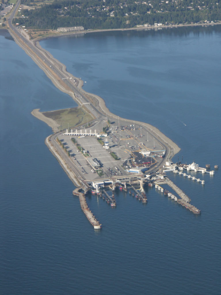
Tsawwassen Ferry Terminal, as part of the BC Ferries system and of Highway 17, is a major transportation facility in Delta, British Columbia, positioned less than from the 49th parallel along the Canada–United States border. It is located at the southwestern end of a artificial causeway that juts out into the Strait of Georgia off the mainland at the community of Tsawwassen. With an approximate size of , it is the largest ferry terminal in North America. History In the late 1950s, the search for a mainland ferry terminal that would connect British Columbia's Lower Mainland with the Victoria area on Vancouver Island involved extensive scouting of locations, from Steveston to White Rock. Despite concerns of rough seas and bad weather, the favoured site soon became the area offshore from the Tsawwassen First Nation Reserve. Construction of the terminal began in 1959, after provincial transportation Minister Phil Gaglardi, on divided engineering advice, selected the site. ... [...More Info...] [...Related Items...] OR: [Wikipedia] [Google] [Baidu] |
BC Ferries
British Columbia Ferry Services Inc., operating as BC Ferries (BCF), is a former provincial Crown corporation, now operating as an independently managed, publicly owned Canadian company. BC Ferries provides all major passenger and vehicle ferry services for coastal and island communities in the Canadian province of British Columbia. Set up in 1960 to provide a similar service to that provided by the Black Ball Line and the Canadian Pacific Railway, which were affected by job action at the time, BC Ferries has become the largest passenger ferry line in North America, operating a fleet of 36 vessels with a total passenger and crew capacity of over 27,000, serving 47 locations on the B.C. coast. The federal and provincial governments subsidize BC Ferries to provide agreed service levels on essential links between the BC mainland, coastal islands, and parts of the mainland without road access. The inland ferries operating on British Columbia's rivers and lakes are not run by BC Fer ... [...More Info...] [...Related Items...] OR: [Wikipedia] [Google] [Baidu] |


