|
Kinleith
Kinleith is a rural settlement in the South Waikato District and Waikato region of New Zealand's North Island. It includes the Kinleith Mill. Statistics New Zealand defines Kinleith as an area covering a land area of . History The estimated population of Kinleith reached 1,190 in 1996, 1,130 in 2001, 1,150 in 2006, 1,540 in 2013, and 2,440 in 2018. Demography Kinleith has an estimated population of . There was a population density of 1.60 people per km2 in 2009. As of the 2018 New Zealand census, 2018 census, the median age was 30.0, the median income was $42,400, 9.3% of people earned over $100,00, 14.2% had a bachelor's degree or higher, and 3.5% of the workforce was unemployed. Ethnically, the population was 83.6% New Zealand European, 19.5% Māori, 2.7% Pacific peoples, and 8.5% Asian; 17.0% were born overseas. Religiously, the population was 56.0% non-religious and 32.0% Christian. Economy In 2018, 52.6% of the workforce worked in primary industries, 9.6% worked in manu ... [...More Info...] [...Related Items...] OR: [Wikipedia] [Google] [Baidu] |
Kinleith Mill
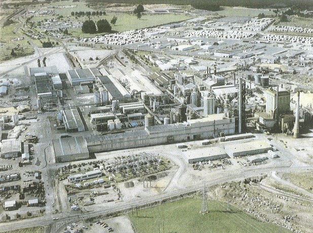
The Kinleith Mill is a pulp and paper plant located at Kinleith, Tokoroa, New Zealand. It is one of eight mills operating in the New Zealand pulp and paper industry. It is currently operated by Oji Fibre Solutions, formerly Carter Holt Harvey Kinleith Mill has a production of approximately 330,000 tonnes of paper grades per year, plus 265,000 tonnes of predominantly bleached wood pulp, pulp. The site boasts its own cogeneration plant operated by Genesis Energy Limited, Genesis Energy, which burns wood waste and generates approximately 40 Watt#Megawatt, MW used mainly on-site, with the rest of the required electricity mainly coming via a 110 kV transmission line direct from the nearby Arapuni Power Station, Arapuni Dam. The mill is Tokoroa’s largest employer, with some 450 employees and 280 additional subcontractors, mainly from ABB Asea Brown Boveri, ABB. A cycleway path runs between the mill and Tokoroa township. Kinleith was established as a sawmill community and dedica ... [...More Info...] [...Related Items...] OR: [Wikipedia] [Google] [Baidu] |
South Waikato District
South Waikato District is a Territorial authorities of New Zealand, local government district in the Waikato, Waikato Region of the North Island of New Zealand. It is located between the cities of Hamilton, New Zealand, Hamilton to the north, Rotorua to the east, Taupō, Taupo to the south and Ruapehu District to the west. The seat of the South Waikato District Council is at Tokoroa, the biggest town. The other main towns are Putāruru, Putaruru, Tīrau, Tirau and Arapuni. Populated places South Waikato District consists of the following towns, localities, settlements and communities: * Putaruru Ward: ** ''Arahiwi West''1 ** Arapuni ** ''Hodderville, New Zealand, Hodderville'' ** Lichfield, New Zealand, Lichfield ** Ngatira ** ''North Putāruru, North Putaruru'' ** ''Pinedale, New Zealand, Pinedale'' ** ''Puketurua'' ** Putāruru, Putaruru ** Waotu * Tirau Ward: ** Okoroire ** ''Piarere'' ** Tapapa ** Tīrau, Tirau ** ''Waiomou'' * Tokoroa Ward: ** Kinleith, New Zealand, Kinl ... [...More Info...] [...Related Items...] OR: [Wikipedia] [Google] [Baidu] |
Waikato
Waikato () is a Regions of New Zealand, local government region of the upper North Island of New Zealand. It covers the Waikato District, Waipa District, Matamata-Piako District, South Waikato District and Hamilton, New Zealand, Hamilton City, as well as Hauraki Plains, Hauraki, Coromandel Peninsula, the northern King Country, much of the Taupō District, and parts of Rotorua, Rotorua District. It is governed by the Waikato Regional Council. The region stretches from Coromandel Peninsula in the north, to the north-eastern slopes of Mount Ruapehu in the south, and spans the North Island from the west coast, through the Waikato and Hauraki to Coromandel Peninsula on the east coast. Broadly, the extent of the region is the Waikato River catchment. Other major catchments are those of the Waihou River, Waihou, Piako River, Piako, Awakino River (Waikato), Awakino and Mokau River, Mokau rivers. The region is bounded by Auckland Region, Auckland on the north, Bay of Plenty on the east ... [...More Info...] [...Related Items...] OR: [Wikipedia] [Google] [Baidu] |
North Island
The North Island, also officially named Te Ika-a-Māui, is one of the two main islands of New Zealand, separated from the larger but much less populous South Island by the Cook Strait. The island's area is , making it the world's 14th-largest island. The world's 28th-most-populous island, Te Ika-a-Māui has a population of accounting for approximately % of the total residents of New Zealand. Twelve main urban areas (half of them officially cities) are in the North Island. From north to south, they are Whangārei, Auckland, Hamilton, Tauranga, Rotorua, Gisborne, New Plymouth, Napier, Hastings, Whanganui, Palmerston North, and New Zealand's capital city Wellington, which is located at the south-west tip of the island. Naming and usage Although the island has been known as the North Island for many years, in 2009 the New Zealand Geographic Board found that, along with the South Island, the North Island had no official name. After a public consultation, the board officially ... [...More Info...] [...Related Items...] OR: [Wikipedia] [Google] [Baidu] |
Statistics New Zealand
Statistics New Zealand ( mi, Tatauranga Aotearoa), branded as Stats NZ, is the public service department of New Zealand charged with the collection of statistics related to the economy, population and society of New Zealand. To this end, Stats NZ produces censuses and surveys. Organisation Statistics New Zealand employs people with a variety of skills, including statisticians, mathematicians, computer science specialists, accountants, economists, demographers, sociologists, geographers, social psychologists, and marketers. There are seven organisational subgroups each managed by a Deputy Government Statistician: * Macro-economic and Environment Statistics studies prices, national accounts, develops macro-economic statistics, does government and international accounts, and ANZSIC 06 implementation (facilitating changeover to new classification code developed jointly with Australian statistics officials.) * Social and Population Statistics studies population, social conditions, ... [...More Info...] [...Related Items...] OR: [Wikipedia] [Google] [Baidu] |
2018 New Zealand Census
Eighteen or 18 may refer to: * 18 (number), the natural number following 17 and preceding 19 * one of the years 18 BC, AD 18, 1918, 2018 Film, television and entertainment * ''18'' (film), a 1993 Taiwanese experimental film based on the short story ''God's Dice'' * ''Eighteen'' (film), a 2005 Canadian dramatic feature film * 18 (British Board of Film Classification), a film rating in the United Kingdom, also used in Ireland by the Irish Film Classification Office * 18 (''Dragon Ball''), a character in the ''Dragon Ball'' franchise * "Eighteen", a 2006 episode of the animated television series ''12 oz. Mouse'' Music Albums * ''18'' (Moby album), 2002 * ''18'' (Nana Kitade album), 2005 * '' 18...'', 2009 debut album by G.E.M. Songs * "18" (5 Seconds of Summer song), from their 2014 eponymous debut album * "18" (One Direction song), from their 2014 studio album ''Four'' * "18", by Anarbor from their 2013 studio album '' Burnout'' * "I'm Eighteen", by Alice Cooper commo ... [...More Info...] [...Related Items...] OR: [Wikipedia] [Google] [Baidu] |


