|
Khorgo
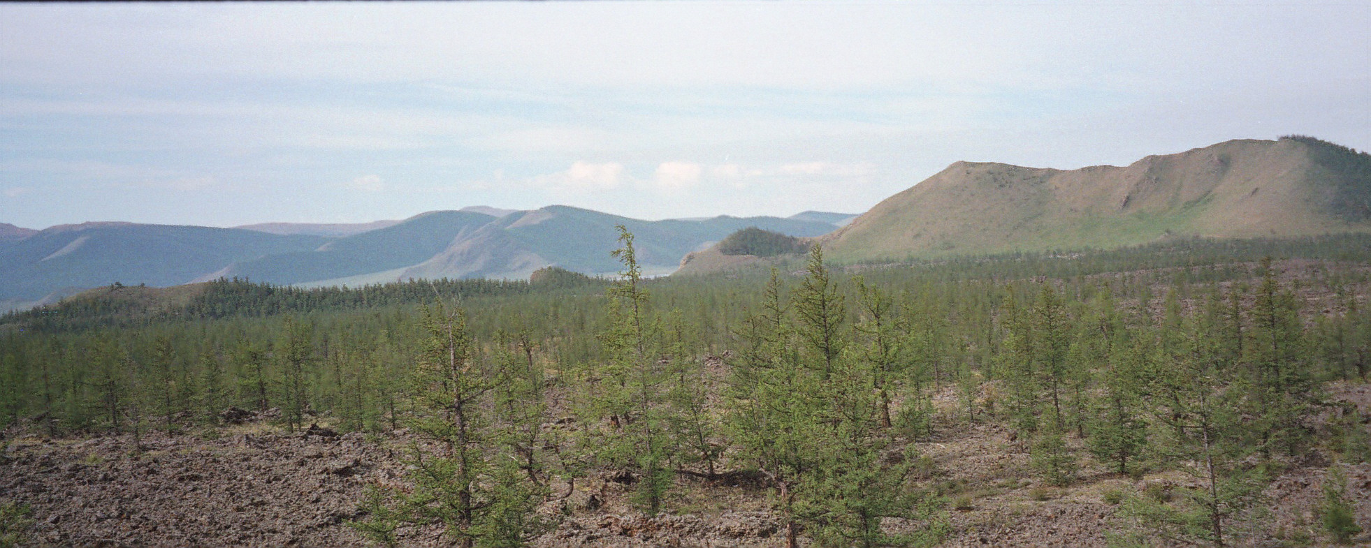
The Horgo ( mn, Хорго) is a volcano in the Taryatu-Chulutu volcanic field in the Tariat district in the Arkhangai Province of Mongolia. The Horgo lies east of the lake Terkhiin Tsagaan Nuur and together they are the core of the Khorgo-Terkhiin Tsagaan Nuur National Park. A notable geological feature are solidified lava bubbles, which the locals have named "basalt yurt A yurt (from the Turkic languages) or ger ( Mongolian) is a portable, round tent covered and insulated with skins or felt and traditionally used as a dwelling by several distinct nomadic groups in the steppes and mountains of Central Asia ...s". (hungarian) References Volcanoes of Mongolia {{Mongolia-geo-stub ... [...More Info...] [...Related Items...] OR: [Wikipedia] [Google] [Baidu] |
Khorgo-Terkhiin Tsagaan Nuur National Park
Khorgo-Terkhiin Tsagaan Nuur National Park ( mn, Тэрхийн Цагаан нуур) covers the picturesque Terkhiin Tsagaan Lake and the nearby Khorgo Mountain (a recently extinct volcano) in the north central khangai Mountains of Mongolia. The marshes along the west end of the lake are an important breeding and staging area for birds. The park is located in Tariat District of Arkhangai Province. Topography The park is situated in the valley of the Chuluut River and Suman River in the Tarvagatai Range of the Khangai Mountains. Lake Terkhiin Tsagaain is a freshwater, oligotrophic lake in a volcanically-formed valley. The terrain immediately around the lake is hills with steppe and forest steppe vegetation. The lake is about 15 km long. It has a maximum depth of 20 meters, with 40% being less than 2 meters deep. Khorgo Mountain is about 4 km east of the lake, in the Taryatu-Chulutu valley, a volcanic field. Khorgo experienced a significant eruption in approxim ... [...More Info...] [...Related Items...] OR: [Wikipedia] [Google] [Baidu] |
Taryatu-Chulutu
Taryatu-Chulutu ( mn, Тариатын чулуут, ''tariatyn chuluut'', "rocks of Tariat") is a volcanic field in Mongolia. It is part of a volcanic area in Central Asia in the Hangai range that may be linked to the rifting of the Lake Baikal Rift. The field itself is located within the valleys of the Chuluut and Suman rivers. Volcanic activity occurred in the Miocene, Pliocene, Pleistocene and Holocene. The Khorgo cinder cone erupted during the Holocene and lava flows from it formed a lava dam generating Terkhiin Tsagaan Nuur lake. Geological context The volcanic field lies in the Taryatu depression, on the northern slope of the Hangai range. There, the field spans the river valleys of the Chuluut River, its tributary Gichigin and the Suman River rivers. The field is sometimes named ''Tariat volcanic field'' after the town of Tariat. Rivers frequently run in canyons bordered by lava plains. Tectonically, the field is located within the Tarvagatay terrane which formed ... [...More Info...] [...Related Items...] OR: [Wikipedia] [Google] [Baidu] |
Tariat
Tariat ( mn, Тариат, crop) is a sum (district) of Arkhangai Province in central Mongolia. As of 2009 it had a population of 5086 people (mainly Chalcha) in 2009, 644 of whom lived in the village of Tariat. Geography Tariat is located northwest of Tsetserleg, the capital of the province. To west of the town is Khorgo-Terkhiin Tsagaan Nuur National Park, noted for its striking crater Khorgo. The Chuluut River flows through the district. In 1977 the Soviet geologist Kavel discovered rock images along the river. Education The school in Tariat was attended by the Mongolian Social Democratic Party politician Radnaasümbereliin Gonchigdorj Radnaasümbereliin Gonchigdorj ( mn, Раднаасүмбэрэлийн Гончигдорж; born 1953) is Mongolian politician from the Mongolian Social Democratic Party and he has served twice as the Chairman of the legislature of Mongolia fr .... References Populated places in Mongolia Districts of Arkhangai Province ... [...More Info...] [...Related Items...] OR: [Wikipedia] [Google] [Baidu] |
Arkhangai Province
The Arkhangai Province or Arkhangai Aimag ( mn, Архангай аймаг, Arhangai aimag, ; "North Khangai") is one of the 21 aimags of Mongolia. It is located slightly west of the country's center, on the northern slopes of the Khangai Mountains. It is composed of 19 soums. Geography The Arkhangai aimag is located in the interior of the country and borders to the following other aimags: Bulgan (north east), Övörkhangai (south east), Bayankhongor (south), Zavkhan (west), and Khövsgöl (north west). The highest point is Kharlagtai Peak at 3,529 m (11,578 ft), while the lowest point is the area on the confluence of the Orkhon and Tamir rivers at 1,290 m (4,232 ft). The most well-known mountain is the extinct volcano Khorgo, which is part of the Khorgo-Terkhiin Tsagaan Nuur National Park. Bodies of water The rivers Chuluut, Khanui, and Tamir have their origins in the valleys of the Khangai Mountains. Together with some smaller tributaries t ... [...More Info...] [...Related Items...] OR: [Wikipedia] [Google] [Baidu] |
Terkhiin Tsagaan Nuur
Terkhiin Tsagaan Lake ( mn, Тэрхийн Цагаан нуур, Terkhiin Tsagaan nuur, , zh, 特尔赫查干湖, 特尔赫查干淖尔), also known as The White Lake, is a lake in the Khangai Mountains in central Mongolia Mongolia; Mongolian script: , , ; lit. "Mongol Nation" or "State of Mongolia" () is a landlocked country in East Asia, bordered by Russia to the north and China to the south. It covers an area of , with a population of just 3.3 million, .... The Khorgo volcano is located near the eastern end of the lake and the Suman River springs from lake. The lake is located in Khorgo-Terkhiin Tsagaan Nuur National Park. See also * Taryatu-Chulutu References Lakes of Mongolia Ramsar sites in Mongolia {{Mongolia-geo-stub ... [...More Info...] [...Related Items...] OR: [Wikipedia] [Google] [Baidu] |
Volcano
A volcano is a rupture in the crust of a planetary-mass object, such as Earth, that allows hot lava, volcanic ash, and gases to escape from a magma chamber below the surface. On Earth, volcanoes are most often found where tectonic plates are diverging or converging, and most are found underwater. For example, a mid-ocean ridge, such as the Mid-Atlantic Ridge, has volcanoes caused by divergent tectonic plates whereas the Pacific Ring of Fire has volcanoes caused by convergent tectonic plates. Volcanoes can also form where there is stretching and thinning of the crust's plates, such as in the East African Rift and the Wells Gray-Clearwater volcanic field and Rio Grande rift in North America. Volcanism away from plate boundaries has been postulated to arise from upwelling diapirs from the core–mantle boundary, deep in the Earth. This results in hotspot volcanism, of which the Hawaiian hotspot is an example. Volcanoes are usually not created where two tectonic plates slide ... [...More Info...] [...Related Items...] OR: [Wikipedia] [Google] [Baidu] |
Volcanic Field
A volcanic field is an area of Earth's crust that is prone to localized volcanic activity. The type and number of volcanoes required to be called a "field" is not well-defined. Volcanic fields usually consist of clusters of up to 100 volcanoes such as cinder cones. Lava flows may also occur. They may occur as a monogenetic volcanic field or a polygenetic volcanic field. Description Alexander von Humboldt observed in 1823 that geologically young volcanoes are not distributed uniformly across the Earth's surface, but tend to be clustered into specific regions. Young volcanoes are rarely found within cratons, but are characteristic of subduction zones, rift zones, or in ocean basins. Intraplate volcanoes are clustered along hotspot traces. Within regions of volcanic activity, volcanic fields are clusters of volcanoes that share a common magma source. Scoria cones are particularly prone to cluster into volcanic fields, which are typically in diameter and consist of several tens ... [...More Info...] [...Related Items...] OR: [Wikipedia] [Google] [Baidu] |
Mongolia
Mongolia; Mongolian script: , , ; lit. "Mongol Nation" or "State of Mongolia" () is a landlocked country in East Asia, bordered by Russia to the north and China to the south. It covers an area of , with a population of just 3.3 million, making it the world's most sparsely populated sovereign nation. Mongolia is the world's largest landlocked country that does not border a closed sea, and much of its area is covered by grassy steppe, with mountains to the north and west and the Gobi Desert to the south. Ulaanbaatar, the capital and largest city, is home to roughly half of the country's population. The territory of modern-day Mongolia has been ruled by various nomadic empires, including the Xiongnu, the Xianbei, the Rouran, the First Turkic Khaganate, and others. In 1206, Genghis Khan founded the Mongol Empire, which became the largest contiguous land empire in history. His grandson Kublai Khan conquered China proper and established the Yuan dynasty. After the co ... [...More Info...] [...Related Items...] OR: [Wikipedia] [Google] [Baidu] |
Yurt
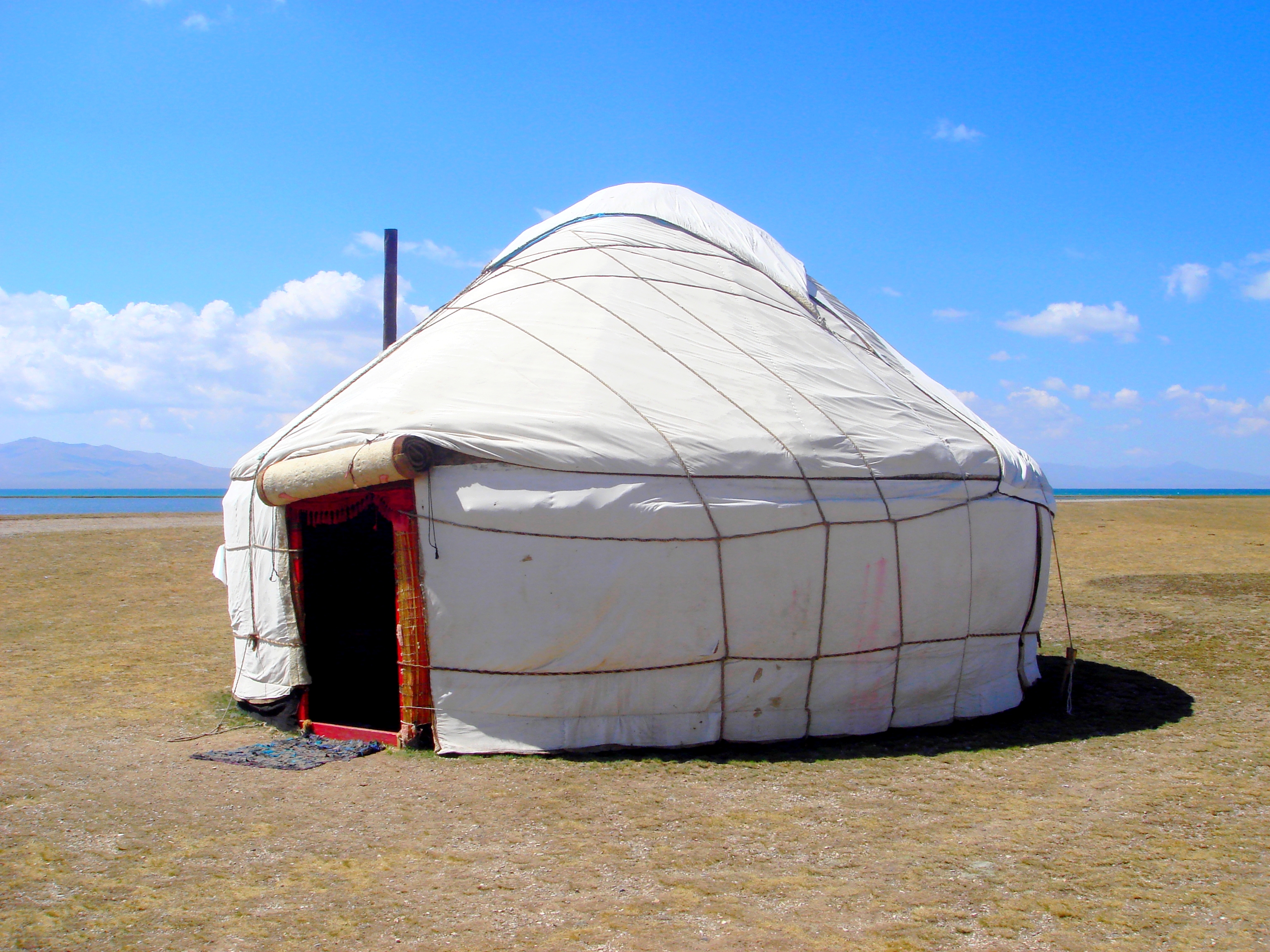
A yurt (from the Turkic languages) or ger ( Mongolian) is a portable, round tent covered and insulated with skins or felt and traditionally used as a dwelling by several distinct nomadic groups in the steppes and mountains of Central Asia. The structure consists of a flexible angled assembly or latticework of wood or bamboo for walls, a door frame, ribs (poles, rafters), and a wheel (crown, compression ring) possibly steam-bent as a roof. The roof structure is sometimes self-supporting, but large yurts may have interior posts supporting the crown. The top of the wall of self-supporting yurts is prevented from spreading by means of a tension band which opposes the force of the roof ribs. Yurts take between 30 minutes and 3 hours to set up or take down, and are generally used by between five and 15 people. Nomadic farming with yurts as housing has been the primary life style in Central Asia, particularly Mongolia, for thousands of years. Modern yurts may be permanently built ... [...More Info...] [...Related Items...] OR: [Wikipedia] [Google] [Baidu] |


