|
Kerguelen
The Kerguelen Islands ( or ; in French commonly ' but officially ', ), also known as the Desolation Islands (' in French), are a archipelago, group of islands in the subantarctic, sub-Antarctic constituting one of the two exposed parts of the Kerguelen Plateau, a large igneous province mostly submerged in the southern Indian Ocean. They are among the Extremes on Earth#Remoteness, most isolated places on Earth, located more than from Madagascar. The islands, along with Adélie Land, the Crozet Islands, Île Amsterdam, Amsterdam and Île Saint-Paul, Saint Paul islands, and France's Scattered Islands in the Indian Ocean, are part of the French Southern and Antarctic Lands and are administered as a separate district. The main island, Grande Terre, is in area, about three quarters of the size of Corsica, and is surrounded by a further 300 smaller islands and islets, forming an archipelago of . The climate is harsh and chilly with frequent high winds throughout the year. The surro ... [...More Info...] [...Related Items...] OR: [Wikipedia] [Google] [Baidu] |
Kerguelen Plateau
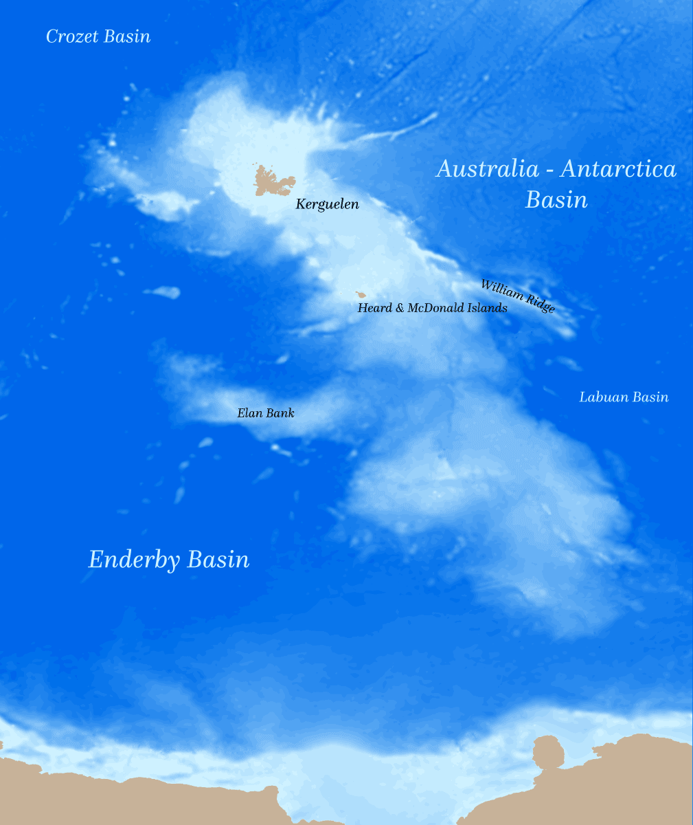
The Kerguelen Plateau (, ), also known as the Kerguelen–Heard Plateau, is an oceanic plateau and a large igneous province (LIP) located on the Antarctic Plate, in the southern Indian Ocean. It is about to the southwest of Australia and is nearly three times the size of California. The plateau extends for more than in a northwest–southeast direction and lies in deep water. The plateau was produced by the Kerguelen hotspot, starting with or following the breakup of Gondwana about 130 million years ago. A small portion of the plateau breaks sea level, forming the Kerguelen Islands (a French overseas territory) plus the Heard and McDonald Islands (an Australian external territory). Intermittent volcanism continues on the Heard and McDonald Islands. Geographical extent Symmetrically across the Indian Ocean ridge and due west of Australia is the Broken Ridge underwater volcanic plateau, which at one time was contiguous with the Kerguelen Plateau before rifting by the mid ... [...More Info...] [...Related Items...] OR: [Wikipedia] [Google] [Baidu] |
Yves-Joseph De Kerguelen-Trémarec
Yves-Joseph de Kerguelen-Trémarec (13 February 1734 – 3 March 1797) was a French Navy officer. He discovered the Kerguelen Islands during his first expedition to the southern Indian Ocean. Welcomed as a hero after his voyage and first discovery, Kerguelen fell out of favour after his second voyage and was cashiered for violating Navy regulations. He was rehabilitated during the French Revolution. Kerguelen also authored books about expeditions and about French naval operations during the American Revolutionary War. Biography Early life He was born in Landudal, Brittany. During the Seven Years' War, Kerguelen-Trémarec was a privateer, but without much success. Rockall In 1767 he sailed near Rockall, or ''Rokol''. Although he may not have approached within sight of it, or even within 150 miles, he appears to have had good information regarding it. His charted position for it was only 16 miles north of its actual position and he accurately described its appearance and t ... [...More Info...] [...Related Items...] OR: [Wikipedia] [Google] [Baidu] |
French Southern And Antarctic Lands
The French Southern and Antarctic Lands (french: Terres australes et antarctiques françaises, TAAF) is an Overseas Territory (french: Territoire d'outre-mer or ) of France. It consists of: # Adélie Land (), the French claim on the continent of Antarctica. # Crozet Islands (), a group in the southern Indian Ocean, south of Madagascar. # Kerguelen Islands (), a group of volcanic islands in the southern Indian Ocean, southeast of Africa. # Saint Paul and Amsterdam Islands (), a group to the north of the Kerguelen Islands. # The Scattered Islands (), a dispersed group of islands around the coast of Madagascar. The territory is sometimes referred to as the French Southern Lands (french: Terres australes françaises) or the French Southern Territories, usually to emphasize non-recognition of French sovereignty over Adélie Land as part of the Antarctic Treaty System. The entire territory has no permanently settled inhabitants. Approximately 150 (in the winter) to 310 (in the summ ... [...More Info...] [...Related Items...] OR: [Wikipedia] [Google] [Baidu] |
Port-aux-Français
Port-aux-Français is the main settlement of the Kerguelen Islands, and French Southern and Antarctic Lands, in the south Indian Ocean. Occupancy The settlement is located on the shore of the Gulf of Morbihan. About 45 residents spend the winter there; the group can reach over 120 people in summer. The place was chosen in 1949 by the head of mission Pierre Sicaud because of its sheltered location which was suitable for the construction of an air runway, though this was never built. From 1955 to 1957, a French slaughterhouse company, SIDAP, built an elephant seal processing plant equipped with Australian machinery. The factory opened its doors just after the wedding of the director, Marc Péchenart, and Martine Raulin on 16 December 1957. This was the first marriage ever celebrated on the islands. The factory closed in 1960, and the equipment was sent to Réunion in 2005. Port-aux-Français has a shallow seaport which allows the unloading of supply ships (usually the '' ... [...More Info...] [...Related Items...] OR: [Wikipedia] [Google] [Baidu] |
Southern Ocean
The Southern Ocean, also known as the Antarctic Ocean, comprises the southernmost waters of the World Ocean, generally taken to be south of 60° S latitude and encircling Antarctica. With a size of , it is regarded as the second-smallest of the five principal oceanic divisions: smaller than the Pacific, Atlantic, and Indian oceans but larger than the Arctic Ocean. Over the past 30 years, the Southern Ocean has been subject to rapid climate change, which has led to changes in the marine ecosystem. By way of his voyages in the 1770s, James Cook proved that waters encompassed the southern latitudes of the globe. Since then, geographers have disagreed on the Southern Ocean's northern boundary or even existence, considering the waters as various parts of the Pacific, Atlantic, and Indian oceans, instead. However, according to Commodore John Leech of the International Hydrographic Organization (IHO), recent oceanographic research has discovered the importance of Southern ... [...More Info...] [...Related Items...] OR: [Wikipedia] [Google] [Baidu] |
Subantarctic
The sub-Antarctic zone is a region in the Southern Hemisphere, located immediately north of the Antarctic region. This translates roughly to a latitude of between 46° and 60° south of the Equator. The subantarctic region includes many islands in the southern parts of the Atlantic, Indian, and Pacific oceans, especially those situated north of the Antarctic Convergence. Sub-Antarctic glaciers are, by definition, located on islands within the sub-Antarctic region. All glaciers located on the continent of Antarctica are by definition considered to be Antarctic glaciers. Geography The sub-Antarctic region comprises two geographic zones and three distinct fronts. The northernmost boundary of the subantarctic region is the rather ill-defined Subtropical Front (STF), also referred to as the Subtropical Convergence. To the south of the STF is a geographic zone, the Subantarctic Zone (SAZ). South of the SAZ is the Subantarctic Front (SAF). South of the SAF is another marine zone, cal ... [...More Info...] [...Related Items...] OR: [Wikipedia] [Google] [Baidu] |
Crozet Islands
The Crozet Islands (french: Îles Crozet; or, officially, ''Archipel Crozet'') are a sub-Antarctic archipelago of small islands in the southern Indian Ocean. They form one of the five administrative districts of the French Southern and Antarctic Lands. History Discovery and early history The Crozet Islands were discovered on 24 January 1772, by the expedition of French explorer Marc-Joseph Marion du Fresne, aboard ''Le Mascarin''. His second-in-command Jules (Julien-Marie) Crozet landed on Île de la Possession, claiming the archipelago for France. The expedition continued east and landed in New Zealand, where Captain Marion and much of his crew were killed and cannibalized by Maori. Crozet survived the disaster, and successfully led the survivors back to their base in Mauritius. In 1776, Crozet met James Cook at Cape Town, at the start of Cook's third voyage. Crozet shared the charts of his ill-fated expedition, and as Cook sailed eastward, he stopped at the islands, naming ... [...More Info...] [...Related Items...] OR: [Wikipedia] [Google] [Baidu] |
Large Igneous Province
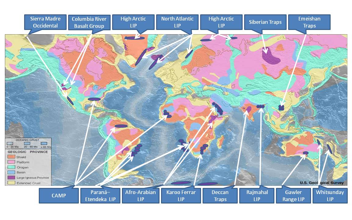
A large igneous province (LIP) is an extremely large accumulation of igneous rocks, including intrusive (sills, dikes) and extrusive (lava flows, tephra deposits), arising when magma travels through the crust towards the surface. The formation of LIPs is variously attributed to mantle plumes or to processes associated with divergent plate tectonics. The formation of some of the LIPs in the past 500 million years coincide in time with mass extinctions and rapid climatic changes, which has led to numerous hypotheses about causal relationships. LIPs are fundamentally different from any other currently active volcanoes or volcanic systems. Definition In 1992 researchers first used the term ''large igneous province'' to describe very large accumulations—areas greater than 100,000 square kilometers (approximately the area of Iceland)—of mafic igneous rocks that were erupted or emplaced at depth within an extremely short geological time interval: a few million years or less. Maf ... [...More Info...] [...Related Items...] OR: [Wikipedia] [Google] [Baidu] |
Île Saint-Paul
Île Saint-Paul (Saint Paul Island) is an island forming part of the French Southern and Antarctic Lands (''Terres australes et antarctiques françaises'', TAAF) in the Indian Ocean, with an area of . The island is located about south of the larger Île Amsterdam (), northeast of the Kerguelen Islands, and southeast of Réunion. It is an important breeding site for seabirds. A scientific research cabin on the island is used for scientific or ecological short campaigns, but there is no permanent population. It is under the authority of a senior administrator on Réunion. Geography Île Saint-Paul is a volcanic island with triangular in shape that measures no more than at its widest point. It is the top of an active volcano; the volcano last erupted in 1793 (from its SW Flank), and is rocky with steep cliffs on the east side. The thin stretch of rock that used to close off the crater collapsed in 1780, admitting the sea through a channel; the entrance is only a few meters d ... [...More Info...] [...Related Items...] OR: [Wikipedia] [Google] [Baidu] |
French Overseas Territory
Overseas France (french: France d'outre-mer) consists of 13 French-administered territories outside Europe, mostly the remains of the French colonial empire that chose to remain a part of the French state under various statuses after decolonization. They are part of the European Union. This collective name is used in everyday life in France but is not an administrative designation in its own right. Instead, the five overseas regions have exactly the same administrative status as the metropolitan regions; the five overseas collectivities are semi-autonomous; and New Caledonia is an autonomous territory. Overseas France includes island territories in the Atlantic, Pacific and Indian Oceans, French Guiana on the South American continent, and several peri-Antarctic islands as well as a claim in Antarctica. Excluding the district of Adélie Land, where French sovereignty is effective ''de jure'' by French law, but where the French exclusive claim on this part of Antarctica is f ... [...More Info...] [...Related Items...] OR: [Wikipedia] [Google] [Baidu] |
Third Voyage Of James Cook
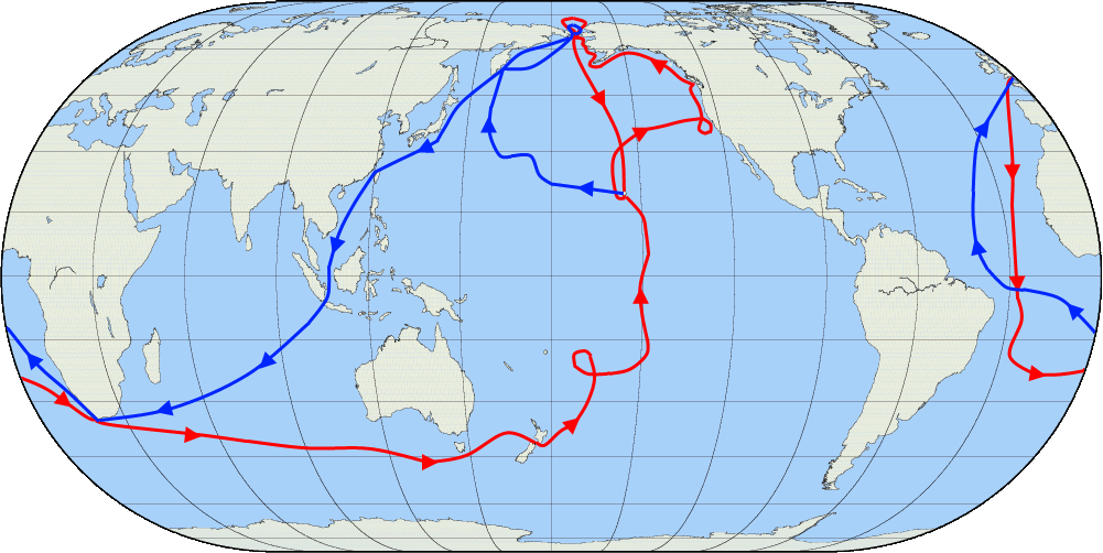
James Cook's third and final voyage (12 July 1776 – 4 October 1780) took the route from Plymouth via Cape Town and Tenerife to New Zealand and the Hawaiian Islands, and along the North American coast to the Bering Strait. Its ostensible purpose was to return Omai, a young man from Raiatea, to his homeland, but the Admiralty used this as a cover for their plan to send Cook on a voyage to discover the Northwest Passage. HMS ''Resolution'', to be commanded by Cook, and HMS ''Discovery'', commanded by Charles Clerke, were prepared for the voyage which started from Plymouth in 1776. Omai was returned to his homeland and the ships sailed onwards, encountering the Hawaiian Archipelago, before reaching the Pacific coast of North America. The two charted the west coast of the continent and passed through the Bering Strait when they were stopped by ice from sailing either east or west. The vessels returned to the Pacific and called briefly at the Aleutians before retiring towar ... [...More Info...] [...Related Items...] OR: [Wikipedia] [Google] [Baidu] |
Extremes On Earth
This article lists extreme locations on Earth that hold geographical records or are otherwise known for their geophysical or meteorological superlatives. All of these locations are Earth-wide extremes; extremes of individual continents or countries are not listed. Latitude and longitude Northernmost * The northernmost point on Earth is the Geographic North Pole, in the Arctic Ocean. ** The northernmost point of land is the northern tip of Kaffeklubben Island, north of Greenland (), which lies slightly north of Cape Morris Jesup, Greenland (). Various shifting gravel bars lie farther north, the most famous being Oodaaq. There have been other islands more northern such as 83-42 and ATOW1996 but they have not been confirmed as permanent. Southernmost * The southernmost point on Earth and the southernmost point on land is the Geographic South Pole, which is on the continent of Antarctica. ** The southernmost continental point of land outside Antarctica is in South America at Cap ... [...More Info...] [...Related Items...] OR: [Wikipedia] [Google] [Baidu] |


_at_St_Paul_Island.jpg)

