|
Katse Airport
Katse Airport is an airport serving the Katse Dam section of the Lesotho Highlands Water Project in north-central Lesotho. The high elevation runway has a overrun on the south end, and a steep dropoff to the Malibamatso River on the north end. Some sections of the runway are built on rock fill and have no shoulder. There are hills and ravines in all quadrants. See also * *Transport in Lesotho *List of airports in Lesotho This is a list of airports in Lesotho, sorted by location. __TOC__ List Airport names that are indicated in bold indicate that the facility has scheduled service on commercial airlines. * not officially identified by ICAO See also * Trans ... References External linksOpenStreetMap - Katse - FallingRain * * Google Earth [...More Info...] [...Related Items...] OR: [Wikipedia] [Google] [Baidu] |
Katse Dam
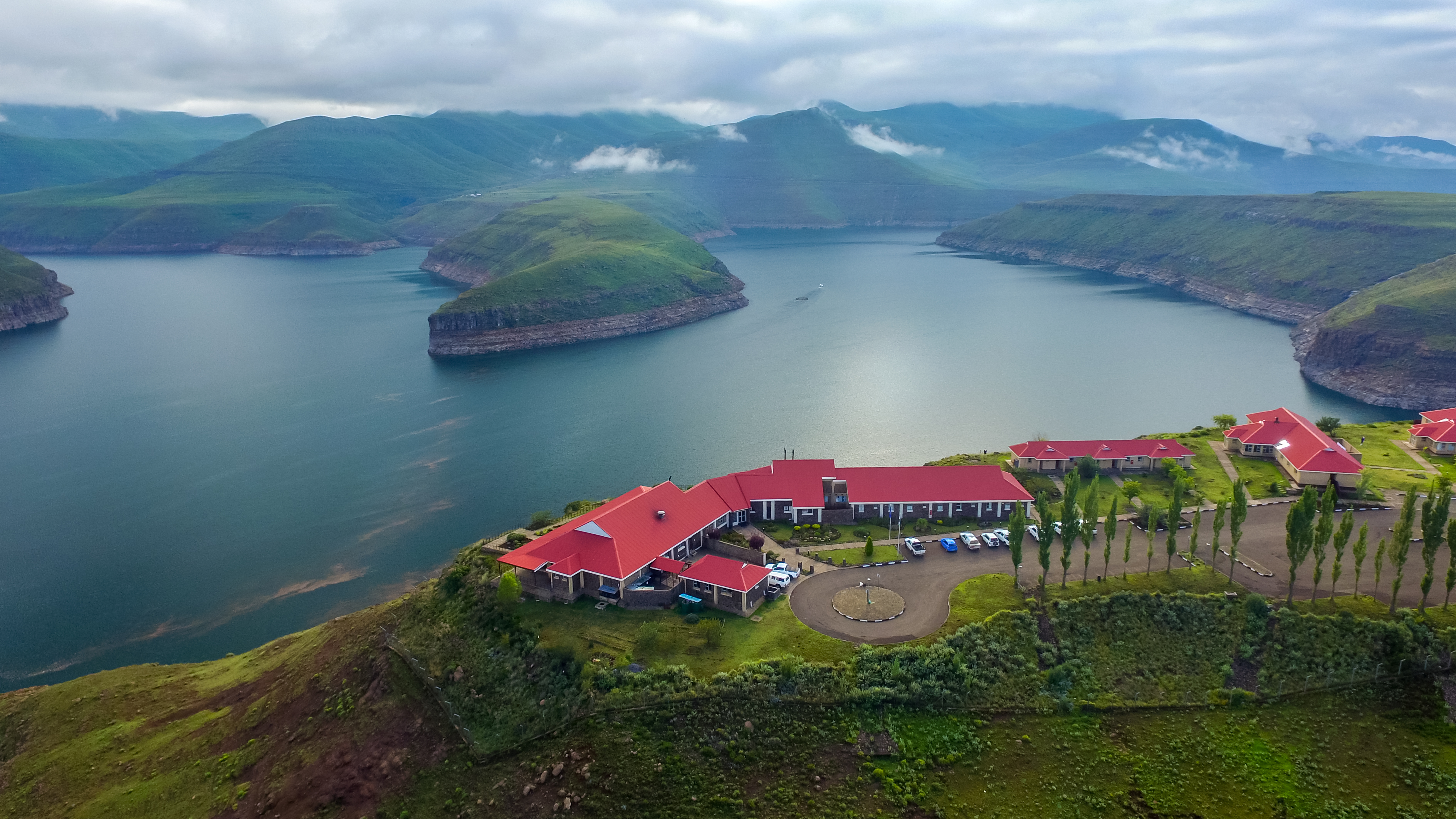
The Katse Dam, a concrete arch dam on the Malibamat'so River in Lesotho, is Africa's second largest double-curvature arch dam. (The Tekezé Dam, completed in early 2009, is now Africa's largest double curvature dam). The dam is part of the Lesotho Highlands Water Project, which will eventually include five large dams in remote rural areas. The dam is just below the confluence of the Bokong River, which forms the western arm of the Katse reservoir. The potential of the project was identified by the South African civil engineer Ninham Shand in 1953 as a possible means to supplement the water supply of South Africa's industrial heartland in the Witwatersrand. The World Bank arranged a treaty between the governments of South Africa and Lesotho, allowing the project to proceed. Construction The dam was built by a consortium of Bouygues, Concor, Group 5, Hochtief, Impregilo, Kier Group and Sterling International. The dam was completed in 1996 and the reservoir filled with water by 1 ... [...More Info...] [...Related Items...] OR: [Wikipedia] [Google] [Baidu] |
Lesotho Highlands Water Project
The Lesotho Highlands Water Project (LHWP) is an ongoing water supply project with a hydropower component, developed in partnership between the governments of Lesotho and South Africa. It comprises a system of several large dams and tunnels throughout Lesotho and delivers water to the Vaal River System in South Africa. In Lesotho, it involves the rivers Malibamatso, Matsoku, Senqunyane, and Senqu. It is Africa's largest water transfer scheme. The purpose of the project is to provide Lesotho with a source of revenue in exchange for the provision of water to South Africa, as well as generate hydroelectricity for Lesotho. As of 2015, royalties paid by South Africa to the Lesotho government amount to R780 million (approximately €50 million), equivalent to about 5% of Lesotho’s state income outside of taxes. The hydro-electric power has enabled Lesotho to become self-sufficient in electricity production, however criticisms have included loss of livelihoods for displaced peopl ... [...More Info...] [...Related Items...] OR: [Wikipedia] [Google] [Baidu] |
Lesotho
Lesotho ( ), officially the Kingdom of Lesotho, is a country landlocked country, landlocked as an Enclave and exclave, enclave in South Africa. It is situated in the Maloti Mountains and contains the Thabana Ntlenyana, highest mountains in Southern Africa. It has an area of over and has a population of about million. It was previously the British Crown colony of Basutoland, which declared independence from the United Kingdom on 4 October 1966. It is a fully sovereign state and is a member of the United Nations, the Commonwealth of Nations, the African Union, and the Southern African Development Community. The name ''Lesotho'' roughly translates to "land of the Sotho". History Basutoland Basutoland emerged as a single body politic, polity under King Moshoeshoe I in 1822. Moshoeshoe, a son of Mokhachane, a minor tribal chief, chief of the Bakoteli lineage, formed his own clan and became a chief around 1804. Between 1820 and 1823, he and his followers settled at the Buth ... [...More Info...] [...Related Items...] OR: [Wikipedia] [Google] [Baidu] |
Malibamatso River
The Malibamat'so River is a river in northern Lesotho. Its origin is near to the South African border, where it drains the eastern slopes of the Maloti Range. It flows southwards past the village of Lejone, and eventually joins the Senqu River northeast of Mohlanapeng. The Malibamat'so forms the northern arm of the Katse Dam reservoir, a part of the Lesotho Highlands Water Project The Lesotho Highlands Water Project (LHWP) is an ongoing water supply project with a hydropower component, developed in partnership between the governments of Lesotho and South Africa. It comprises a system of several large dams and tunnels thr .... Katse is Africa's highest elevation dam at above sea level.Fitzpatrick, M., Blond, B., Pitcher, G., Richmond, S., and Warren, M. (2004) ''South Africa, Lesotho and Swaziland.'' Footscray, VIC: Lonely Planet. Here the river is joined by the Bokong/Bokung River. Downstream the Malibamat'so's left bank tributaries are the Matsoku and Semenanyane Rivers, ... [...More Info...] [...Related Items...] OR: [Wikipedia] [Google] [Baidu] |
Transport In Lesotho
This article concerns systems of transport in Lesotho. As a landlocked country, Lesotho has no seaports or harbours, but does have road, air transport, and limited rail infrastructure. Roads Prior to Lesotho's independence in 1966, the only paved road in the country was the Kingsway in the capital, Maseru, between the Mejametalana Airport and the Royal Palace. Since the early 1970s, the road infrastructure has been substantially developed. In 1999, Lesotho had a road network measuring at in length, of which were paved. The most weight has been given to connecting the district centres, but the roads within central Lesotho have also been improved, as part of the construction needs of the Lesotho Highlands Water Project. Railways The only railway line in Lesotho is the Maseru branch line, which connects the capital city Maseru to the Bloemfontein–Bethlehem line in the railway network of South Africa. The final of this line, which opened on 18 December 1905, lies within t ... [...More Info...] [...Related Items...] OR: [Wikipedia] [Google] [Baidu] |
List Of Airports In Lesotho ...
This is a list of airports in Lesotho, sorted by location. __TOC__ List Airport names that are indicated in bold indicate that the facility has scheduled service on commercial airlines. * not officially identified by ICAO See also * Transport in Lesotho * List of airports by ICAO code: F#FX - Lesotho * Wikipedia: WikiProject Aviation/Airline destination lists: Africa#Lesotho References * * External links * Lists of airports in Lesotho: *Great Circle Mapper**World Aero Data {{Africa in topic, List of airports in Lesotho Airports Airports Lesotho Lesotho ( ), officially the Kingdom of Lesotho, is a country landlocked country, landlocked as an Enclave and exclave, enclave in South Africa. It is situated in the Maloti Mountains and contains the Thabana Ntlenyana, highest mountains in Sou ... [...More Info...] [...Related Items...] OR: [Wikipedia] [Google] [Baidu] |


