|
Karkamış
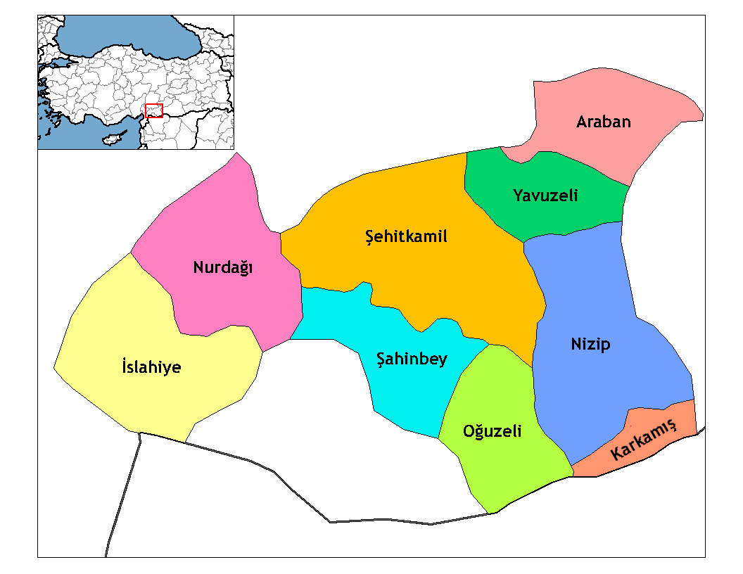
Karkamış is a town and district of Gaziantep Province in southeastern Turkey, next to the site of ancient Karkemish. The population of the town was 2,998 in 2010. It is a border checkpoint on the road to Jarabulus in Syria. In 2004, 8,071 vehicles and 38,263 people passed the border checkpoint into Turkey while 8,795 vehicles and 35,474 people crossed it towards Syria. Geography The Euphrates runs east of Karkamış southward into Syria. At this place, a railway bridge of that was built between 1911 and 1913 by German engineers as part of the Istanbul-Baghdad Railway, crosses the river parallel to the border line. One of the 21 dams of the Southeastern Anatolia Project (GAP), the Karkamış Dam and hydroelectric power station is located upstream from the border crossing of Euphrates. In March 2011, the Turkish military base which included the ruins of Karkemish was cleared of mines. Archaeologists from Italy and Turkey began excavations, still ongoing, in the ancient tow ... [...More Info...] [...Related Items...] OR: [Wikipedia] [Google] [Baidu] |
Karkamış Bridge
The Karkamış Bridge ( tr, Karkamış Köprüsü) is a Parker-truss bridge carrying the Baghdad Railway across the Euphrates in southeastern Turkey. The bridge was built by the Baghdad Railway between 1911-13 in the Ottoman Empire and played an important role for transporting troops and supplies during World War I, as it was the only permanent crossing of the Euphrates in the area. After the war, the bridge and the railway fell under British military control until the Allies withdrew their forces from Turkey. The French-owned Chemins de fer de Cilicie Nord-Syrie, headquartered in French Syria (CNS) took over the railway in 1921 and operated the route until being sold to the Turkish-owned Southern Railway in 1933. This new company owned and operated the railway until being absorbed by the Turkish State Railways in 1948. When first completed, the structure was the second longest bridge in the Ottoman Empire and later Turkey, after Uzunköprü Bridge in East Thrace East ... [...More Info...] [...Related Items...] OR: [Wikipedia] [Google] [Baidu] |
Karkamış Dam
Karkamış Dam is one of the 21 dams of the Southeastern Anatolia Project of Turkey. It is on the Euphrates River. The foundation of the dam was laid in 1996, and is from the Syria Syria ( ar, سُورِيَا or سُورِيَة, translit=Sūriyā), officially the Syrian Arab Republic ( ar, الجمهورية العربية السورية, al-Jumhūrīyah al-ʻArabīyah as-Sūrīyah), is a Western Asian country loc ... border. The hydroelectric power plant has a total installed power capacity of . References External links Official GAP web site* Data sheet Dams completed in 2000 Energy infrastructure completed in 2000 Dams in Gaziantep Province Southeastern Anatolia Project Hydroelectric power stations in Turkey Run-of-the-river power stations Dams in Şanlıurfa Province 2000 establishments in Turkey Crossings of the Euphrates Important Bird Areas of Turkey {{Turkey-powerstation-stub ... [...More Info...] [...Related Items...] OR: [Wikipedia] [Google] [Baidu] |
Karkemish
Carchemish (Turkish: ''Karkamış''; or ), also spelled Karkemish ( hit, ; Hieroglyphic Luwian: , /; Akkadian: ; Egyptian: ; Hebrew: ) was an important ancient capital in the northern part of the region of Syria. At times during its history the city was independent, but it was also part of the Mitanni, Hittite and Neo-Assyrian Empires. Today it is on the frontier between Turkey and Syria. It was the location of an important battle, about 605 BC, between the Babylonians and Egyptians, mentioned in the Bible (Jer. 46:2). Modern neighbouring cities are Karkamış in Turkey and Jarabulus in Syria (also Djerablus, Jerablus, Jarablos, Jarâblos); the original form of the modern toponym seems to have been Djerabis or Jerabis, likely derived from Europos, the ancient name of the Hellenistic-Roman settlement. Geography of the site Carchemish is now an extensive set of ruins (90 hectares, of which 55 lie in Turkey and 35 in Syria), located on the West bank of Eup ... [...More Info...] [...Related Items...] OR: [Wikipedia] [Google] [Baidu] |
Jarabulus
Jarabulus ( ar, جَرَابُلُس / ALA-LC: ''Jarābulus'', Aleppo dialect: ''Jrāblos''; tr, Cerablus) is a Syrian city administratively belonging to Aleppo Governorate, under the de-facto control of the Syrian Opposition. Jarabulus lies on the western bank of the river Euphrates. In the 2004 census, the city had a population of 11,570. The population has increased significantly during the Syrian civil war. Ethnically, the population of city is composed of Arabs and Turkmens. It is located north of Lake Assad, just south of the Syria–Turkey border and the Turkish town of Karkamış. History In the Bronze and Iron Ages, the archaeological site lying just north of Jarabulus (half of which is now in Turkey) was called "Karkemish", in Greek and Roman times the ancient name of the city was "Europos" (Εὐρωπός), which must have been at the origin of the modern form of the toponym Jerabis. The original 18th century form of the toponym seems to have been "Djerabis", ... [...More Info...] [...Related Items...] OR: [Wikipedia] [Google] [Baidu] |
Southeastern Anatolia Project
The Southeastern Anatolia Project ( tr, Güneydoğu Anadolu Projesi, GAP) is a multi-sector integrated regional development project based on the concept of sustainable development for the 9 million people (2005) living in the Southeastern Anatolia region of Turkey. GAP's basic aim is to eliminate regional development disparities by raising incomes and living standards and to contribute to the national development targets of social stability and economic growth by enhancing the productive and employment generating capacity of the rural sector. The total cost of the project is over 100 billion Turkish lira (TL) (2017 adjusted price), of which 30.6 billion TL of this investment was realized at the end of 2010. The real investment (corrected value) was 72.6% for the end of 2010. (in Turkish) The project area covers nine provinces (Adıyaman, Batman, Diyarbakır, Gaziantep, Kilis, Siirt, Şanlıurfa, Mardin, and Şırnak) which are located in the basins of the Euphrates and Tigris and ... [...More Info...] [...Related Items...] OR: [Wikipedia] [Google] [Baidu] |
Syria–Turkey Border
The border between the Syrian Arab Republic and the Republic of Turkey ( ar, الحدود السورية التركية, translit=alhudud alsuwriat alturkia; tr, Suriye–Türkiye sınırı) is about long, and runs from the Mediterranean Sea in the west to the tripoint with Iraq in the east. It runs across Upper Mesopotamia for some , crossing the Euphrates and reaching as far as the Tigris. Much of the border follows the Southern Turkish stretch of the Baghdad Railway, roughly along the 37th parallel between the 37th and 42nd eastern meridians. In the west, it almost surrounds the Turkish Hatay Province, partly following the course of the Orontes River and reaching the Mediterranean coast at the foot of Jebel Aqra. Description Since Turkey's 1939 appropriation of the Hatay State, the Syrian–Turkish border now touches the Mediterranean coast at Ras al-Bassit, south of Mount Aqra (). Hatay province borders the Syrian Latakia and Idlib governorates. The westernmost (and ... [...More Info...] [...Related Items...] OR: [Wikipedia] [Google] [Baidu] |
Gaziantep Province
Gaziantep Province ( tr, ) is a province in south-central Turkey. It is located in the westernmost part of Turkey's Southeastern Anatolia Region and partially in the Mediterranean Region. Its capital is the city of Gaziantep. It neighbours Adıyaman to the northeast, Şanlıurfa to the east, Syria and Kilis to the south, Hatay to the southwest, Osmaniye to the west and Kahramanmaraş to the northwest. An important trading center since ancient times, the province is also one of Turkey's major manufacturing zones, and its agriculture is dominated by the growing of pistachio nuts. In ancient times, first under the power of Yamhad, then the Hittites and later the Assyrians controlled the region. It saw much fighting during the Crusades, and Saladin won a key battle there in 1183. After World War I and the Ottoman Empire's disintegration, it was invaded by the forces of the French Third Republic during the Turkish War of Independence. It was returned to Turkish control after the ... [...More Info...] [...Related Items...] OR: [Wikipedia] [Google] [Baidu] |
British Museum
The British Museum is a public museum dedicated to human history, art and culture located in the Bloomsbury area of London. Its permanent collection of eight million works is among the largest and most comprehensive in existence. It documents the story of human culture from its beginnings to the present.Among the national museums in London, sculpture and decorative and applied art are in the Victoria and Albert Museum; the British Museum houses earlier art, non-Western art, prints and drawings. The National Gallery holds the national collection of Western European art to about 1900, while art of the 20th century on is at Tate Modern. Tate Britain holds British Art from 1500 onwards. Books, manuscripts and many works on paper are in the British Library. There are significant overlaps between the coverage of the various collections. The British Museum was the first public national museum to cover all fields of knowledge. The museum was established in 1753, largely b ... [...More Info...] [...Related Items...] OR: [Wikipedia] [Google] [Baidu] |
Leonard Woolley (right) And T
Sir Charles Leonard Woolley (17 April 1880 – 20 February 1960) was a British archaeologist best known for his excavations at Ur in Mesopotamia. He is recognized as one of the first "modern" archaeologists who excavated in a methodical way, keeping careful records, and using them to reconstruct ancient life and history. Woolley was knighted in 1935 for his contributions to the discipline of archaeology. He married the British archaeologist Katharine Woolley. Early life Woolley was the son of a clergyman, and was brother to Geoffrey Harold Woolley, VC, and George Cathcart Woolley. He was born at 13 Southwold Road, Upper Clapton, in the modern London Borough of Hackney and educated at St John's School, Leatherhead and New College, Oxford. He was interested in excavations from a young age. Career In 1905, Woolley became assistant of the Ashmolean Museum, Oxford. Volunteered by Arthur Evans to run the excavations on the Roman site at Corbridge (near Hadrian's Wall) for Francis ... [...More Info...] [...Related Items...] OR: [Wikipedia] [Google] [Baidu] |
Baghdad Railway
Baghdad (; ar, بَغْدَاد , ) is the capital of Iraq and the second-largest city in the Arab world after Cairo. It is located on the Tigris near the ruins of the ancient city of Babylon and the Sassanid Persian capital of Ctesiphon. In 762 CE, Baghdad was chosen as the capital of the Abbasid Caliphate, and became its most notable major development project. Within a short time, the city evolved into a significant cultural, commercial, and intellectual center of the Muslim world. This, in addition to housing several key academic institutions, including the House of Wisdom, as well as a multiethnic and multi-religious environment, garnered it a worldwide reputation as the "Center of Learning". Baghdad was the largest city in the world for much of the Abbasid era during the Islamic Golden Age, peaking at a population of more than a million. The city was largely destroyed at the hands of the Mongol Empire in 1258, resulting in a decline that would linger through many ... [...More Info...] [...Related Items...] OR: [Wikipedia] [Google] [Baidu] |
Aleppo
)), is an adjective which means "white-colored mixed with black". , motto = , image_map = , mapsize = , map_caption = , image_map1 = , mapsize1 = , map_caption1 = , pushpin_map = Syria#Mediterranean east#Asia#Syria Aleppo , pushpin_label_position = left , pushpin_relief = yes , pushpin_mapsize = , pushpin_map_caption = Location of Aleppo in Syria , coordinates = , subdivision_type = Country , subdivision_name = , subdivision_type1 = Governorate , subdivision_type2 = District , subdivision_type3 = Subdistrict , subdivision_name1 = Aleppo Governorate , subdivision_name2 = Mount Simeon (Jabal Semaan) , subdivision_name3 = Mount Simeon ( ... [...More Info...] [...Related Items...] OR: [Wikipedia] [Google] [Baidu] |


_Q73536.jpg)

