|
Kanapoi
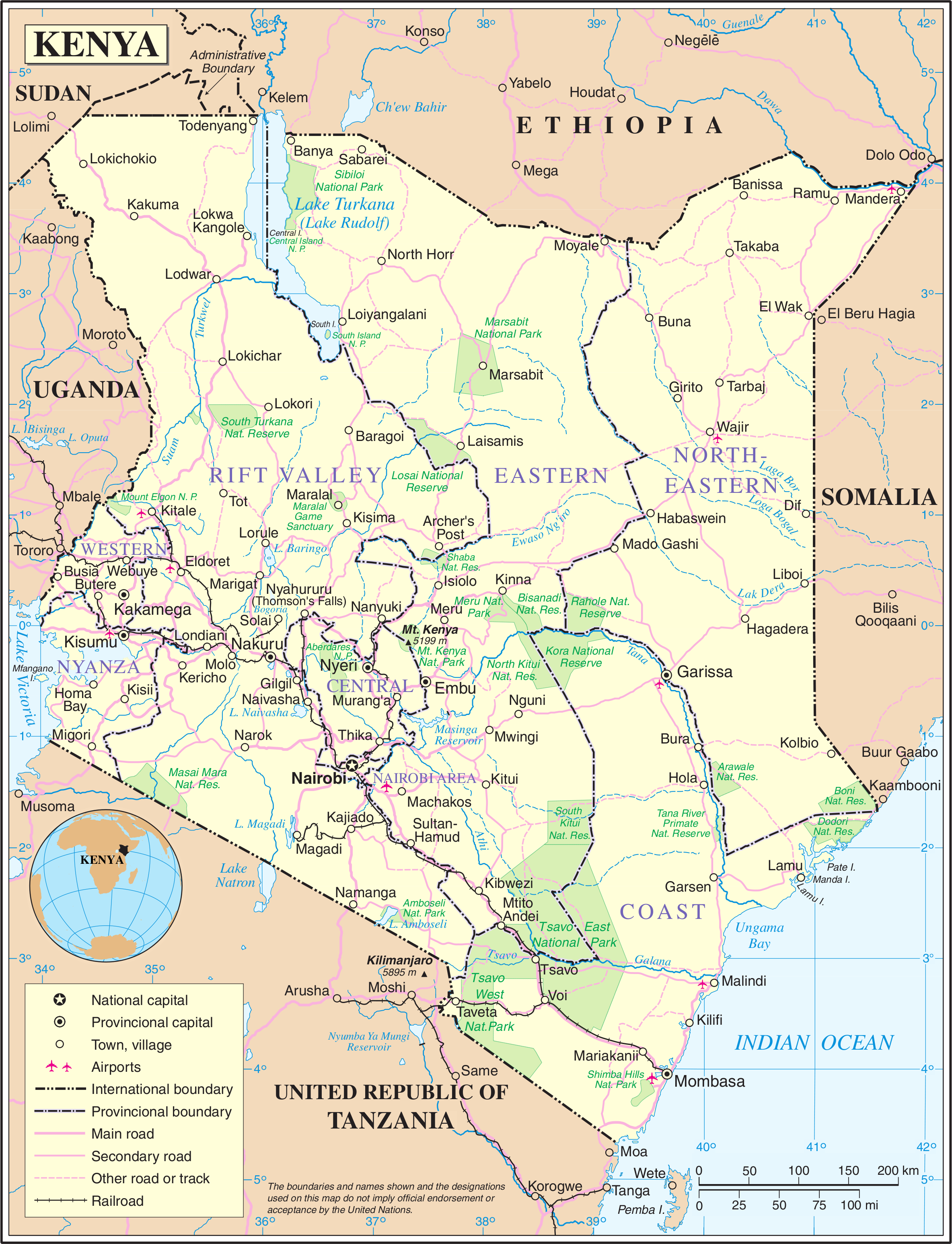
Kanapoi is a paleontological site in the Kenyan Rift Valley, to the southwest of Lake Turkana. Fossils were first found at Kanapoi in the 1960s by a Harvard expedition, and later by expeditions from the National Museums of Kenya. Fossils at Kanapoi were deposited in sediments formed by lake margins, rivers and deltas between 3.4 - 4.2 Million years ago (Ma). Kanapoi fossils include a diverse array of fish, turtles, crocodiles, primates including likely human ancestors, elephants, giraffes, rhinoceroses, rodents, horses, hippos, pigs and a variety of herbivores and carnivores. The hominin ''Australopithecus anamensis'' appears in Kanapoi between 3.9 and 4.2 Ma, one of a number of fossil specimens demonstrating that human ancestors were already bipedal by this time. Kanapoi also is the site of archaeological discoveries. History of investigation Count Sámuel Teleki von Szék and Ludwig von Höhnel were the first European explorers to reach Lake Turkana, in 1888. They named it Lak ... [...More Info...] [...Related Items...] OR: [Wikipedia] [Google] [Baidu] |
Australopithecus Anamensis
''Australopithecus anamensis'' is a hominin species that lived approximately between 4.2 and 3.8 million years ago and is the oldest known ''Australopithecus'' species, living during the Plio-Pleistocene era. Nearly one hundred fossil specimens of ''A. anamensis'' are known from Kenya and Ethiopia, representing over twenty individuals. The first fossils of ''A. anamensis'' discovered, are dated to around 3.8 and 4.2 million years ago and were found in Kanapoi and Allia Bay in Northern Kenya. It is usually accepted that '' A. afarensis'' emerged within this lineage. However, ''A. anamensis'' and ''A. afarensis'' appear to have lived side by side for at least some period of time, and it is not fully settled whether the lineage that led to extant humans emerged in ''A. afarensis'', or directly in ''A. anamensis.'' Fossil evidence determines that ''Australopithecus anamensis'' is the earliest hominin species in the Turkana Basin, but likely co-existed with ''afarensis'' towards the ... [...More Info...] [...Related Items...] OR: [Wikipedia] [Google] [Baidu] |
Etheria (bivalve)
''Etheria'' is a genus of freshwater oysters in the Etheriidae family of mollusk bivalves, and a part of the Unionida order. The genus includes a single species, ''Etheria elliptica'', that is found throughout Africa and Madagascar. ''Etheria elliptica'' was first described by Lamarck in 1807, and lives in river basins along the Nile, Lake Tanganyika and Lake Victoria, and in Chad, Zaire, Niger, Senegal, and Angola. ''Etheria'' are found as fossils at paleontological sites in Africa, including at Lake Turkana 3-5 million years ago. It first appears in the Miocene The Miocene ( ) is the first geological epoch of the Neogene Period and extends from about (Ma). The Miocene was named by Scottish geologist Charles Lyell; the name comes from the Greek words (', "less") and (', "new") and means "less recen ... in northeast Zaire. References Etheriidae Bivalves described in 1807 Monotypic mollusc genera {{bivalve-stub ... [...More Info...] [...Related Items...] OR: [Wikipedia] [Google] [Baidu] |
Lothagam
Lothagam is a geological formation located in Kenya, near the southwestern shores of Lake Turkana, from Kanapoi. It is located between the Kerio and Lomunyenkuparet Rivers on an uplifted fault block. Lothagam has deposits dating to the Miocene-Pliocene period and numerous palaeontological finds have been recovered here. Archaeological sites dating to the Holocene are also found at Lothagam, including the Lothagam Lokam harpoon site and the Lothagam North Pillar Site. Background Bryan Patterson from Harvard University was, in 1967, the first to carry out paleontological research at Lothagam. Meave Leakey has also carried out extensive paleontological research at Lothagam. See also * List of fossil sites This list of fossil sites is a worldwide list of localities known well for the presence of fossils. Some entries in this list are notable for a single, unique find, while others are notable for the large number of fossils found there. Many of t ... References Pliocene ... [...More Info...] [...Related Items...] OR: [Wikipedia] [Google] [Baidu] |
NASA Kanapoi
The National Aeronautics and Space Administration (NASA ) is an independent agency of the US federal government responsible for the civil space program, aeronautics research, and space research. NASA was established in 1958, succeeding the National Advisory Committee for Aeronautics (NACA), to give the U.S. space development effort a distinctly civilian orientation, emphasizing peaceful applications in space science. NASA has since led most American space exploration, including Project Mercury, Project Gemini, the 1968-1972 Apollo Moon landing missions, the Skylab space station, and the Space Shuttle. NASA supports the International Space Station and oversees the development of the Orion spacecraft and the Space Launch System for the crewed lunar Artemis program, Commercial Crew spacecraft, and the planned Lunar Gateway space station. The agency is also responsible for the Launch Services Program, which provides oversight of launch operations and countdown management for ... [...More Info...] [...Related Items...] OR: [Wikipedia] [Google] [Baidu] |
Kerio River
The Kerio River is a river in Turkana County, Kenya. It flows northward into Lake Turkana. It is one of the longest rivers in Kenya, originating near the equator. Course The Kerio River rises on the north slopes of the Amasya Hills to the west of Lake Bogoria. It flows northward through the Kerio Valley between Tugen Hills and Elgeyo Escarpment. The Elgeyo Escarpment rises to over above the Kerio valley in places. The Kerio continues northward, often through deep and narrow valleys, to enter Lake Turkana in a delta just south of the delta formed by the Turkwel and Lokichar rivers. The Kerio and Turkwel contribute 98% of the river water flowing into Lake Turkana on Kenyan territory (which makes up only 2% of the total riverine inflow). In their lower courses both these rivers are seasonal. Near its source the Kerio River is fed by two major tributaries flowing down Elgeyo Escarpment: Arror River, and Embobut River. Land use The Lake Kamnarok National Reserve and Kerio Val ... [...More Info...] [...Related Items...] OR: [Wikipedia] [Google] [Baidu] |
Geology Of Kenya
The Geography of Kenya is diverse, varying amongst its Counties of Kenya, 47 counties. Kenya has a coastline on the Indian Ocean, which contains swamps of East African mangroves. Inland are broad plains and numerous hills. Kenya borders South Sudan to the northwest, Uganda to the west, Somalia to the east, Tanzania to the south, and Ethiopia to the north. Central and Western Kenya is characterised by the Kenyan Rift Valley and central Province home to the highest mountain, Mount Kenya and Mount Elgon on the border between Kenya and Uganda. The Kakamega Forest in western Kenya is a relic of an East African rainforest. Much bigger is Mau Forest, the largest forest complex in East Africa. Geography Location * Eastern Africa on the Indian Ocean coast between Somalia and Tanzania * Geographic coordinates: Area * Total: * Land: * Water: Land boundaries * Total: * Border countries: Ethiopia , Somalia , South Sudan , Tanzania , Uganda Coastline * 536 km (333 ... [...More Info...] [...Related Items...] OR: [Wikipedia] [Google] [Baidu] |
Pliocene Paleontological Sites Of Africa
The Pliocene ( ; also Pleiocene) is the epoch in the geologic time scale that extends from 5.333 million to 2.58See the 2014 version of the ICS geologic time scale million years ago. It is the second and most recent epoch of the Neogene Period in the . The Pliocene follows the Epoch and is followed by the Epoch. Prior to the 2009 ... [...More Info...] [...Related Items...] OR: [Wikipedia] [Google] [Baidu] |
Bellamya (gastropod)
''Bellamya'' is a genus of freshwater snails with a gill and an operculum, aquatic gastropod mollusks in the family Viviparidae. MolluscaBase eds. (2020). MolluscaBase. Bellamya Jousseaume, 1886. Accessed through: World Register of Marine Species at: http://www.marinespecies.org/aphia.php?p=taxdetails&id=716177 on 2020-06-09 ''Bellamya'' is the type genus of the subfamily Bellamyinae. Distribution The indigenous distribution of ''Bellamya'' includes Africa and Asia. Species Species within the genus ''Bellamya'' include: * '' Bellamya alberti'' (Cox, 1926) † * '' Bellamya beijiangensis'' Yü & Zhang, 1982 † * '' Bellamya campaniformis'' Bickel, 1976 † * '' Bellamya capillata'' (Frauenfeld, 1865)Brown D. S. (1994). ''Freshwater Snails of Africa and their Medical Importance''. Taylor & Francis Taylor & Francis Group is an international company originating in England that publishes books and academic journals. Its parts include Taylor & Francis, Routledge, F1000 ... [...More Info...] [...Related Items...] OR: [Wikipedia] [Google] [Baidu] |
Pliocene
The Pliocene ( ; also Pleiocene) is the epoch in the geologic time scale that extends from 5.333 million to 2.58See the 2014 version of the ICS geologic time scale million years ago. It is the second and most recent epoch of the Neogene Period in the . The Pliocene follows the Epoch and is followed by the Epoch. Prior to the 2009 ... [...More Info...] [...Related Items...] OR: [Wikipedia] [Google] [Baidu] |
Bryan Patterson
Bryan Patterson (born 10 March 1909 in London; died 1 December 1979 in Chicago) was an American paleontologist at the Field Museum of Natural History in Chicago. Life and career Bryan Patterson was the son of the soldier, engineer and author John Henry Patterson and Frances Gray Patterson, who was one of the first to receive a law degree granted to a woman in the British Isles. He moved in 1926 to the Hyde Park area of Chicago, Illinois. Upon his arrival in Chicago, Bryan assumed a position as vertebrate preparator at the Field Museum of Natural History. He worked under the direction of Elmer S. Riggs, who was at that time engaged in studies of South American Tertiary mammals. By self-education he rose rapidly in rank, and by 1937 became curator of paleontology. He became an American citizen in 1938. In 1934 he met and married Bernice Cain. He and Bernice had one son. He served in Europe with the U.S. Army 1st Infantry Division during World War II. During that time he was ... [...More Info...] [...Related Items...] OR: [Wikipedia] [Google] [Baidu] |
Turkwel River
The Turkwel River (sometimes spelled Turkwell River) is a river flowing from Mount Elgon on the border of Kenya and Uganda to Lake Turkana. The river is called the Suam River from its source to the border at West Pokot County of Kenya. The name Turkwel is derived from the Turkana name for the river, ''Tir-kol'', which means a river that "withstands the wilderness". The Turkwel begins on the lush green slopes of Mount Elgon and the Cherangani Hills, then traverses the Southern Turkana Plains, crosses the Loturerei Desert near Lodwar and empties into the world's largest desert lake, Lake Turkana. The river's flow is seasonally varied, and it is subject to flash floods in the rainy season. The controversial Turkwel Dam The Turkwel Hydroelectric Power Station, also Turkwel Dam, is an arch dam on the Turkwel River about north of Kapenguria in West Pokot County, Kenya. The dam serves several purposes to include hydroelectric power production, irrigation tourism a ... was built by t ... [...More Info...] [...Related Items...] OR: [Wikipedia] [Google] [Baidu] |
Lake Turkana
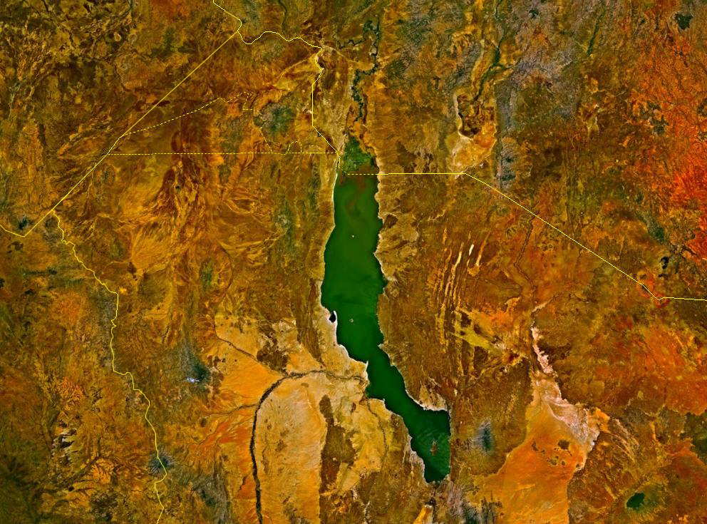
Lake Turkana (), formerly known as Lake Rudolf, is a lake in the Kenyan Rift Valley, in northern Kenya, with its far northern end crossing into Ethiopia. It is the world's largest permanent desert lake and the world's largest alkaline lake. By volume it is the world's fourth-largest salt lake after the Caspian Sea, Issyk-Kul, and Lake Van (passing the shrinking South Aral Sea), and among all lakes it ranks 24th. Lake Turkana is now threatened by the construction of Gilgel Gibe III Dam in Ethiopia due to the damming of the Omo river which supplies most of the lake's water. Although the lake commonly has been —and to some degree still is— used for drinking water, its salinity (slightly brackish) and very high levels of fluoride (much higher than in fluoridated water) generally make it unsuitable, and it has also been a source of diseases spread by contaminated water. Increasingly, communities on the lake's shores rely on underground springs for drinking water. The same c ... [...More Info...] [...Related Items...] OR: [Wikipedia] [Google] [Baidu] |


