|
Kamloops Lake
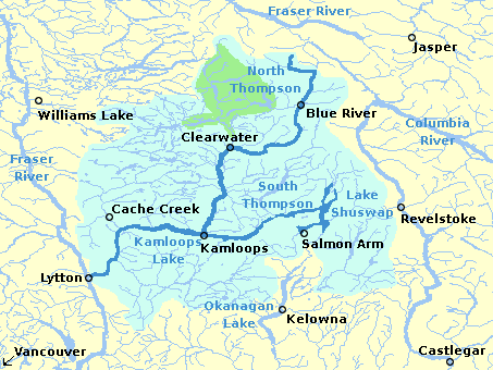
Kamloops Lake in British Columbia, Canada is situated on the Thompson River just west of Kamloops. The lake is 1.6 km wide, 29 km long, and up to 152 m deep. In prehistoric time, the lake was much longer, perhaps 20x, with adjacent silt cliffs defining ancient lake bottoms 100 meters higher than present water levels. At the outlet near Savona, a large tumbled rock, gravel moraine indicates the toe of a glacier once melted away here. The community of Savona is located at the west end of the lake, near the Thompson River outlet. The city of Kamloops is located a few miles east of the head of the lake, at the confluence of the North and South Thompson Rivers. The name, Kamloops, derives from a local Indigenous word, Tk’emlúps, meaning a meeting of waters. The lake is bounded on all sides by steep hillsides, with level areas found only near creek deltas and around the inlet. On these hills, fresh, green grass feeds herds of Mule Deer and Rocky Mountain Sheep in th ... [...More Info...] [...Related Items...] OR: [Wikipedia] [Google] [Baidu] |
British Columbia
British Columbia (commonly abbreviated as BC) is the westernmost province of Canada, situated between the Pacific Ocean and the Rocky Mountains. It has a diverse geography, with rugged landscapes that include rocky coastlines, sandy beaches, forests, lakes, mountains, inland deserts and grassy plains, and borders the province of Alberta to the east and the Yukon and Northwest Territories to the north. With an estimated population of 5.3million as of 2022, it is Canada's third-most populous province. The capital of British Columbia is Victoria and its largest city is Vancouver. Vancouver is the third-largest metropolitan area in Canada; the 2021 census recorded 2.6million people in Metro Vancouver. The first known human inhabitants of the area settled in British Columbia at least 10,000 years ago. Such groups include the Coast Salish, Tsilhqotʼin, and Haida peoples, among many others. One of the earliest British settlements in the area was Fort Victoria, established ... [...More Info...] [...Related Items...] OR: [Wikipedia] [Google] [Baidu] |
Ponderosa Pine
''Pinus ponderosa'', commonly known as the ponderosa pine, bull pine, blackjack pine, western yellow-pine, or filipinus pine is a very large pine tree species of variable habitat native to mountainous regions of western North America. It is the most widely distributed pine species in North America.Safford, H.D. 2013. Natural Range of Variation (NRV) for yellow pine and mixed conifer forests in the bioregional assessment area, including the Sierra Nevada, southern Cascades, and Modoc and Inyo National Forests. Unpublished report. USDA Forest Service, Pacific Southwest Region, Vallejo, CA/ref> ''Pinus ponderosa'' grows in various erect forms from British Columbia southward and eastward through 16 western U.S. states and has been successfully introduced in temperate regions of Europe, and in New Zealand. It was first documented in modern science in 1826 in eastern Washington near present-day Spokane (of which it is the official city tree). On that occasion, David Douglas misidenti ... [...More Info...] [...Related Items...] OR: [Wikipedia] [Google] [Baidu] |
Lakes Of British Columbia
A lake is an area filled with water, localized in a basin, surrounded by land, and distinct from any river or other outlet that serves to feed or drain the lake. Lakes lie on land and are not part of the ocean, although, like the much larger oceans, they do form part of the Earth's water cycle. Lakes are distinct from lagoons, which are generally coastal parts of the ocean. Lakes are typically larger and deeper than ponds, which also lie on land, though there are no official or scientific definitions. Lakes can be contrasted with rivers or streams, which usually flow in a channel on land. Most lakes are fed and drained by rivers and streams. Natural lakes are generally found in mountainous areas, rift zones, and areas with ongoing glaciation. Other lakes are found in endorheic basins or along the courses of mature rivers, where a river channel has widened into a basin. Some parts of the world have many lakes formed by the chaotic drainage patterns left over from the last ice ... [...More Info...] [...Related Items...] OR: [Wikipedia] [Google] [Baidu] |
Painted Bluffs Provincial Park
Painted Bluffs Provincial Park is a provincial park in British Columbia, Canada, located on the north side of Kamloops Lake Kamloops Lake in British Columbia, Canada is situated on the Thompson River just west of Kamloops. The lake is 1.6 km wide, 29 km long, and up to 152 m deep. In prehistoric time, the lake was much longer, perhaps 20x, with adjacent silt ... at the outlet of Copper Creek. References * {{coord, 50, 47, 45, N, 120, 45, 15, W, display=title Provincial parks of British Columbia Thompson Country 1996 establishments in British Columbia Protected areas established in 1996 ... [...More Info...] [...Related Items...] OR: [Wikipedia] [Google] [Baidu] |
Shuswap Lakes
Shuswap Lake (pronounced /ˈʃuːʃwɑːp/) is a lake located in the southern interior of British Columbia, Canada that drains via the Little Shuswap River into Little Shuswap Lake. Little Shuswap Lake is the source of the South Thompson River, a branch of the Thompson River, a tributary of the Fraser River. It is at the heart of a region known as the Columbia Shuswap or "the Shuswap", noted for its recreational lakeshore communities including the city of Salmon Arm. The name "Shuswap" is derived from the Shuswap or Secwepemc First Nations people, the most northern of the Interior Salish peoples, whose territory includes the Shuswap. The Shuswap call themselves /ʃǝxwépmǝx/ in their own language, which is called /ʃǝxwepmǝxtʃín/. Geography The central interior plateau of British Columbia drained by the Fraser and Okanagan rivers is part of the Shuswap terrane in British Columbia and northern Washington state. It is dissected by numerous elongated, glacially- overdeepen ... [...More Info...] [...Related Items...] OR: [Wikipedia] [Google] [Baidu] |
Freshet
The term ''freshet'' is most commonly used to describe a spring thaw resulting from snow and ice melt in rivers located in upper North America. A spring freshet can sometimes last several weeks on large river systems, resulting in significant inundation of flood plains as the snowpack melts in the river's watershed. Freshets can occur with differing strength and duration depending upon the depth of the snowpack and the local average rates of warming temperatures. Deeper snowpacks which melt quickly can result in more severe flooding. Late spring melts allow for faster flooding; this is because the relatively longer days and higher solar angle allow for average melting temperatures to be reached quickly, causing snow to melt rapidly. Snowpacks at higher altitudes and in mountainous areas remain cold and tend to melt over a longer period of time and thus do not contribute to major flooding. Serious flooding from southern freshets are more often related to rain storms of large tropi ... [...More Info...] [...Related Items...] OR: [Wikipedia] [Google] [Baidu] |
Spruce
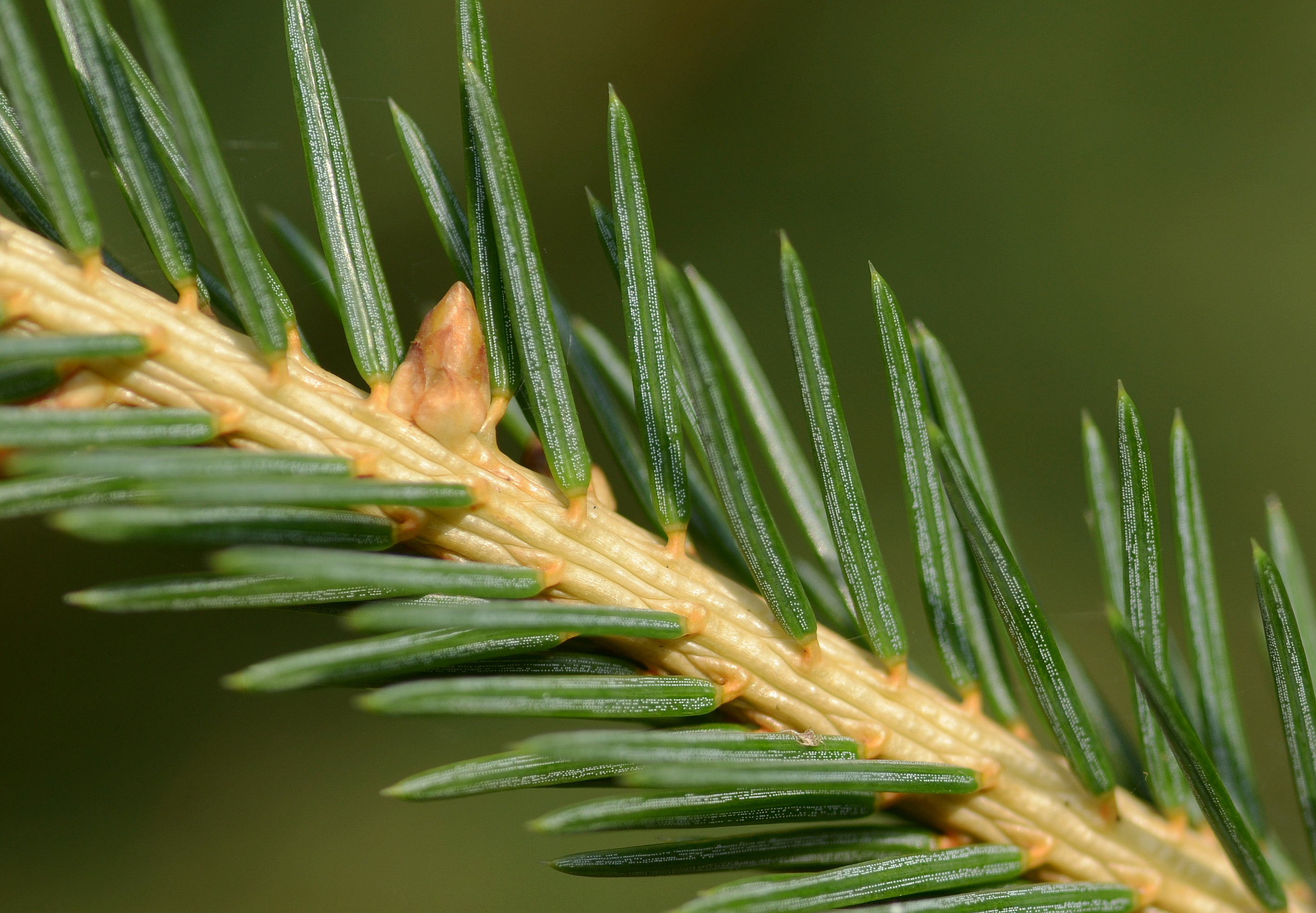
A spruce is a tree of the genus ''Picea'' (), a genus of about 35 species of coniferous evergreen trees in the family Pinaceae, found in the northern temperate and boreal (taiga) regions of the Earth. ''Picea'' is the sole genus in the subfamily Piceoideae. Spruces are large trees, from about 20 to 60 m (about 60–200 ft) tall when mature, and have whorled branches and conical form. They can be distinguished from other members of the pine family by their needles (leaves), which are four-sided and attached singly to small persistent peg-like structures (pulvini or sterigmata) on the branches, and by their cones (without any protruding bracts), which hang downwards after they are pollinated. The needles are shed when 4–10 years old, leaving the branches rough with the retained pegs. In other similar genera, the branches are fairly smooth. Spruce are used as food plants by the larvae of some Lepidoptera (moth and butterfly) species, such as the eastern spruce budwo ... [...More Info...] [...Related Items...] OR: [Wikipedia] [Google] [Baidu] |
Douglas Fir
The Douglas fir (''Pseudotsuga menziesii'') is an evergreen conifer species in the pine family, Pinaceae. It is native to western North America and is also known as Douglas-fir, Douglas spruce, Oregon pine, and Columbian pine. There are three varieties: coast Douglas-fir (''P. menziesii'' var. ''menziesii''), Rocky Mountain Douglas-fir (''P. menziesii'' var. ''glauca'') and Mexican Douglas-fir (''P. menziesii'' var. ''lindleyana''). Despite its common names, it is not a true fir (genus ''Abies''), spruce (genus '' Picea''), or pine (genus ''Pinus''). It is also not a hemlock; the genus name ''Pseudotsuga'' means "false hemlock". Description Douglas-firs are medium-size to extremely large evergreen trees, tall (although only ''Pseudotsuga menziesii var. menziesii'', common name coast Douglas-firs, reach heights near 100 m) and commonly reach in diameter, although trees with diameters of almost exist. The largest coast Douglas-firs regularly live over 500 years, with the old ... [...More Info...] [...Related Items...] OR: [Wikipedia] [Google] [Baidu] |
Thompson River
The Thompson River is the largest tributary of the Fraser River, flowing through the south-central portion of British Columbia, Canada. The Thompson River has two main branches, the South Thompson River and the North Thompson River. The river is home to several varieties of Pacific salmon and trout. The area's geological history was heavily influenced by glaciation, and the several large glacial lakes have filled the river valley over the last 12,000 years. Archaeological evidence shows human habitation in the watershed dating back at least 8,300 years. The Thompson was named by Fraser River explorer, Simon Fraser, in honour of his friend, Columbia Basin explorer David Thompson. Recreational use of the river includes whitewater rafting and angling. Geography South Thompson River The South Thompson originates at the outlet of Little Shuswap Lake at the town of Chase and flows approximately southwest through a wide valley to Kamloops where it joins the North Thompson. High ... [...More Info...] [...Related Items...] OR: [Wikipedia] [Google] [Baidu] |
Sagebrush
Sagebrush is the common name of several woody and herbaceous species of plants in the genus ''Artemisia''. The best known sagebrush is the shrub ''Artemisia tridentata''. Sagebrushes are native to the North American west. Following is an alphabetical list of common names for various species of the genus ''Artemisia'', along with their corresponding scientific name. Many of these species are known by more than one common name, and some common names represent more than one species. * Alpine sagebrush—' * African sagebrush—''Artemisia afra'' * Basin sagebrush—''Artemisia tridentata'' * Big sagebrush—see Basin sagebrush * Bigelow sagebrush—''Artemisia bigelovii'' * Birdfoot sagebrush—'' Artemisia pedatifida'' * Black sagebrush—''Artemisia nova'' * Blue sagebrush—see Basin sagebrush * Boreal sagebrush—'' Artemisia norvegica'' * Budsage—''Artemisia spinescens'' * California sagebrush—''Artemisia californica'' * Carruth's sagebrush—'' Artemisia carruthii'' * C ... [...More Info...] [...Related Items...] OR: [Wikipedia] [Google] [Baidu] |


.jpeg)

