|
Kakrak Valley, Bamyan Province
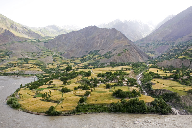
Karkak Valley ( prs, درهٔ ککرک ) is a valley in central Afghanistan, located in Bamyan province, 120 km west of Kabul province. The famous Buddhist mural named "The Hunter King" (7-8th centuries CE) shows a typically local royal figure seated on a throne, his bow and arrows on the side. He wears a triple-crescent crown which has been compared to the triple-crescent crowns on the coinage found in northeastern Afghanistan in the area of Zabulistan, such as a coin found in Ghazni. Late 7th to early 8th century CE. Other authors have attributed the triple-crescent crown to Hephthalite influence. The painting may be an allegory of a King abandoning violence, particularly the hunting of animals, and converting to Buddhism."According to Jäger's interpretation, the so-called "Hunter-King" was a symbolic representation of a royal person who converted to Buddhism and abandoned hunting and violence in general." in Murals from Kakrak File:Kakrak Hunter King.jpg, The triple-cre ... [...More Info...] [...Related Items...] OR: [Wikipedia] [Google] [Baidu] |
Valleys Of Afghanistan
As a mountainous country, Afghanistan contains countless notable valleys. The majority of the valleys are located in parts of northeastern, central, southern and southeastern Afghanistan. The southeastern areas are wetter and are covered by forest with trees such as cypress, oak, poplar, pine etc. Northern Hindu Kush mountain valleys Wakhan valleys include Sheghnan, Ashava, Darwaz, Drayem, Arsj, Hnjab, Farkhar, Ishkamish District valley, Khost i Fereng, Samandan, Andrab, Khenjan, Tala wa Barfak. Southern Hindu Kush valleys Panj Valley, Korm, Panjdarh Nijrab, Bandavol, Eshpi, Shishil, Kepchaq, Chardeh, Sayghan, Kahmard, Salang, Darzab, Panjshir, Ghorband District, Surobi, etc. Koh-i-Baba mountain valleys Koh-i-Baba is located in central Afghanistan and contains the valleys of Koladi, Bamiyan, Kakrak, Turkman and others. Safēd Kōh mountain valleys Valleys include Khyber Pass, Nazyan District, Shinwar District, Achen, Zarmast, Jajy, Khogyani, Kjah, Nakrokh ... [...More Info...] [...Related Items...] OR: [Wikipedia] [Google] [Baidu] |
Provinces Of Afghanistan
Afghanistan is divided into 34 provinces (, '' wilåyat''). The provinces of Afghanistan are the primary administrative divisions. Each province encompasses a number of districts or usually over 1,000 villages. Provincial governors played a critical role in the reconstruction of the Afghan state following the creation of the new government under Hamid Karzai. According to international security scholar Dipali Mukhopadhyay, many of the provincial governors of the western-backed government were former warlords who were incorporated into the political system. Provinces of Afghanistan Regions of Afghanistan UN Regions Former provinces of Afghanistan During Afghanistan's history it had a number of provinces in it. It started out as just Kabul, Herat, Qandahar, and Balkh but the number of provinces increased and by 1880 the provinces consisted of Balkh, Herat, Qandahar, Ghazni, Jalalabad, and Kabul. * Southern Province – dissolved in 1964 to create Paktia Provinc ... [...More Info...] [...Related Items...] OR: [Wikipedia] [Google] [Baidu] |
Districts Of Afghanistan
The districts of Afghanistan, known as ''wuleswali'' ( ps, ولسوالۍ, ''wuləswāləi''; fa, شهرستان, ''shahrestān'') are secondary-level administrative units, one level below provinces. The Afghan government issued its first district map in 1973.''Afghanistan; Districts and Codes by Province'', Edition 2.0, AID / Rep. DC&A Mapping Unit, October 1991, Peshawar, Pakista/ref> It recognized 325 districts, counting ''wuleswalis'' (districts), ''alaqadaries'' (sub-districts), and ''markaz-e-wulaiyat'' (provincial center districts). In the ensuing years, additional districts have been added through splits, and some eliminated through merges. In June 2005, the Afghan government issued a map of 398 districts. It was widely adopted by many information management systems, though usually with the addition of ''Sharak-e-Hayratan'' for 399 districts in total. It remains the ''de facto'' standard as of late 2018, despite a string of government announcements of the creation of ... [...More Info...] [...Related Items...] OR: [Wikipedia] [Google] [Baidu] |
Bamyan Province
Bamyan Province ( prs, ولایت بامیان) also spelled Bamiyan, Bāmīān or Bāmyān is one of the thirty-four provinces of Afghanistan, located in the central highlands of the Afghanistan. The terrain in Bamyan is mountainous or semi-mountainous, at the western end of the Hindu Kush mountains concurrent with the Himalayas. The province is divided into eight districts, with the town of Bamyan serving as its capital. The province has a population of about 495,557 and borders Samangan to the north, Baghlan, Parwan and Wardak to the east, Ghazni and Daykundi to the south, and Ghor and Sar-e Pol to the west. It is the largest province in the Hazarajat region of Afghanistan and is the cultural capital of the Hazara ethnic group that predominates in the area. It was a center of commerce and Buddhism in the 4th and 5th centuries. In antiquity, central Afghanistan was strategically placed to thrive from the Silk Road caravans that crisscrossed the region, trading between the ... [...More Info...] [...Related Items...] OR: [Wikipedia] [Google] [Baidu] |
Hazara People
The Hazaras ( fa, , Həzārə; haz, , Āzərə) are an ethnic group and the principal component of the population of Afghanistan, native to, and primarily residing in the Hazaristan (Hazarajat) region in central Afghanistan and generally scattered throughout Afghanistan. They are one of the largest ethnic groups in Afghanistan, and are also significant minority groups in neighboring Pakistan, mostly in Quetta, and as well as in Iran. They speak the Hazaragi dialect of Persian, which is mutually intelligible with Dari, one of the two official languages of Afghanistan. Hazaras are considered to be one of the most persecuted groups in Afghanistan, and their persecution has occurred various times across previous decades. Etymology The etymology of the word "Hazara" remains disputed, but some have differing views on the term. *Babur, founder of the Mughal Empire in the early 16th century, records the name "Hazara" in Baburnama. He has mentioned "Hazara" as "Turkoman Hazaras" se ... [...More Info...] [...Related Items...] OR: [Wikipedia] [Google] [Baidu] |
Afghanistan
Afghanistan, officially the Islamic Emirate of Afghanistan,; prs, امارت اسلامی افغانستان is a landlocked country located at the crossroads of Central Asia and South Asia. Referred to as the Heart of Asia, it is bordered by Pakistan to the Durand Line, east and south, Iran to the Afghanistan–Iran border, west, Turkmenistan to the Afghanistan–Turkmenistan border, northwest, Uzbekistan to the Afghanistan–Uzbekistan border, north, Tajikistan to the Afghanistan–Tajikistan border, northeast, and China to the Afghanistan–China border, northeast and east. Occupying of land, the country is predominantly mountainous with plains Afghan Turkestan, in the north and Sistan Basin, the southwest, which are separated by the Hindu Kush mountain range. , Demographics of Afghanistan, its population is 40.2 million (officially estimated to be 32.9 million), composed mostly of ethnic Pashtuns, Tajiks, Hazaras, and Uzbeks. Kabul is the country's largest city and ser ... [...More Info...] [...Related Items...] OR: [Wikipedia] [Google] [Baidu] |
Bamyan Province
Bamyan Province ( prs, ولایت بامیان) also spelled Bamiyan, Bāmīān or Bāmyān is one of the thirty-four provinces of Afghanistan, located in the central highlands of the Afghanistan. The terrain in Bamyan is mountainous or semi-mountainous, at the western end of the Hindu Kush mountains concurrent with the Himalayas. The province is divided into eight districts, with the town of Bamyan serving as its capital. The province has a population of about 495,557 and borders Samangan to the north, Baghlan, Parwan and Wardak to the east, Ghazni and Daykundi to the south, and Ghor and Sar-e Pol to the west. It is the largest province in the Hazarajat region of Afghanistan and is the cultural capital of the Hazara ethnic group that predominates in the area. It was a center of commerce and Buddhism in the 4th and 5th centuries. In antiquity, central Afghanistan was strategically placed to thrive from the Silk Road caravans that crisscrossed the region, trading between the ... [...More Info...] [...Related Items...] OR: [Wikipedia] [Google] [Baidu] |
Kabul Province
Kabul (Persian: ), situated in the east of the country, is one of the thirty-four provinces of Afghanistan. The capital of the province is Kabul city, which is also Afghanistan's capital and largest city. The population of the Kabul Province is over 5 million people as of 2020, of which over 85 percent live in urban areas. The current governor of the province is Qari Baryal. It borders the provinces of Parwan to the north, Kapisa to the north-east, Laghman to the east, Nangarhar to the south-east, Logar to the south, and Wardak to the west. Geography Kabul is located between Latitude 34-31' North and Longitude 69-12' East at an altitude of 1800 m (6000 feet) above sea level, which makes it one of the world's highest capital cities. Kabul is strategically situated in a valley surrounded by high mountains at crossroads of north-south and east-west trade routes. One million years ago the Kabul region was surrounded from south-east between Lowgar and Paghman Mountains ... [...More Info...] [...Related Items...] OR: [Wikipedia] [Google] [Baidu] |
Zabulistan
Zabulistan ( fa, زابلستان ''Zābulistān''/''Zābolistān''/''Zāwulistān'' or simply ''Zābul'', ps, زابل ''Zābəl''), was a historical region in southern Afghanistan roughly corresponding to the modern provinces of Zabul and Ghazni. Following the Ghaznavid rule (977–1186), "Zabul" became largely synonymous with the name of its capital and main city, Ghazni. By the tenth century, Islamic sources mention Zabulistan as part of the ''Khorasan marches'', a frontier region between Khorasan and India. In the Tarikh-i Sistan, finished around 1062 CE, the author regards Zabul as part of the land of Sistan, stretching from the Hamun Oasis all the way to the Indus River. Today, the modern Afghan province of Zabul and the Iranian city Zabol take their names from the historical region. Zabulistan has become popularized as the birthplace of the character Rostam of Ferdowsi's Shahnameh, in which the word "Zabulistan" is used interchangeably with "Sistan", which was a ... [...More Info...] [...Related Items...] OR: [Wikipedia] [Google] [Baidu] |
Ghazni
Ghazni ( prs, غزنی, ps, غزني), historically known as Ghaznain () or Ghazna (), also transliterated as Ghuznee, and anciently known as Alexandria in Opiana ( gr, Αλεξάνδρεια Ωπιανή), is a city in southeastern Afghanistan with a population of around 190,000 people. The city is strategically located along Highway 1, which has served as the main road between Kabul and Kandahar for thousands of years. Situated on a plateau at 2,219 metres (7,280 ft) above sea level, the city is south of Kabul and is the capital of Ghazni Province. Ghazni Citadel, the Minarets of Ghazni, the Palace of Sultan Mas'ud III, and several other cultural heritage sites have brought travelers and archeologists to the city for centuries. During the pre-Islamic period, the area was inhabited by various tribes who practiced different religions including Zoroastrianism, Buddhism and Hinduism. Arab Muslims introduced Islam to Ghazni in the 7th century and were followed in the 9th ... [...More Info...] [...Related Items...] OR: [Wikipedia] [Google] [Baidu] |
Hephthalite
The Hephthalites ( xbc, ηβοδαλο, translit= Ebodalo), sometimes called the White Huns (also known as the White Hunas, in Iranian as the ''Spet Xyon'' and in Sanskrit as the ''Sveta-huna''), were a people who lived in Central Asia during the 5th to 8th centuries CE. They formed an empire, the Imperial Hephthalites, and were militarily important from 450 CE, when they defeated the Kidarites, to 560 CE, when combined forces from the First Turkic Khaganate and the Sasanian Empire defeated them. After 560 CE, they established "principalities" in the area of Tokharistan, under the suzerainty of the Western Turks (in the areas north of the Oxus) and of the Sasanian Empire (in the areas south of the Oxus), before the Tokhara Yabghus took over in 625. The Imperial Hephthalites, based in Bactria, expanded eastwards to the Tarim Basin, westwards to Sogdia and southwards through Afghanistan, but they never went beyond the Hindu-Kush, which was occupied by the Alchon Huns, previously m ... [...More Info...] [...Related Items...] OR: [Wikipedia] [Google] [Baidu] |


