|
Karst Window
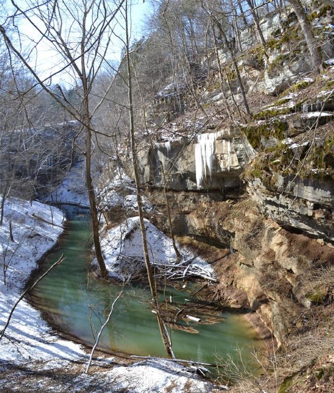
A karst window, also known as a karst fenster, is a geomorphic feature found in karst landscapes where an underground river is visible from the surface within a sinkhole. In this feature, a spring emerges, then the discharge abruptly disappears into a sinkhole. The word ''fenster'' is German for 'window', as these features are windows into the karst landscape. The term is used to denote an unroofed portion of a cavern which reveals part of a subterranean river. A complex system of caves, known as karst topography, evolves from the effects of water erosion on carbonate rocks such as limestone, dolomite or gypsum. "A karst fenster is caused by a caving in of portions of the roof of a subterranean stream, thus making some of the underground stream visible from the surface".*Ritter, Michael E. The Physical Environment: an Introduction to Physical Geography. 2006. Dec 2009. Theories in the creation of karst topography and karst fensters involve vadose water above the water table, and ... [...More Info...] [...Related Items...] OR: [Wikipedia] [Google] [Baidu] |
Geomorphic
Geomorphology (from Ancient Greek: , ', "earth"; , ', "form"; and , ', "study") is the scientific study of the origin and evolution of topographic and bathymetric features created by physical, chemical or biological processes operating at or near Earth's surface. Geomorphologists seek to understand why landscapes look the way they do, to understand landform and terrain history and dynamics and to predict changes through a combination of field observations, physical experiments and numerical modeling. Geomorphologists work within disciplines such as physical geography, geology, geodesy, engineering geology, archaeology, climatology, and geotechnical engineering. This broad base of interests contributes to many research styles and interests within the field. Overview Earth's surface is modified by a combination of surface processes that shape landscapes, and geologic processes that cause tectonic uplift and subsidence, and shape the coastal geography. Surface processes compr ... [...More Info...] [...Related Items...] OR: [Wikipedia] [Google] [Baidu] |
Phreatic
''Phreatic'' is a term used in hydrology to refer to aquifers, in speleology to refer to cave passages, and in volcanology to refer to a type of volcanic eruption. Hydrology The term phreatic (the word originates from the Greek , meaning "well" or "spring") is used in hydrology and the earth sciences to refer to matters relating to ground water (an aquifer) below the water table. The term 'phreatic surface' indicates the location where the pore water pressure is under atmospheric conditions (i.e. the pressure head is zero). This surface normally coincides with the water table. The slope of the phreatic surface is assumed to indicate the direction of ground water movement in an unconfined aquifer. The phreatic zone, below the phreatic surface where rock and soil is saturated with water, is the counterpart of the vadose zone, or unsaturated zone, above. Unconfined aquifers are also referred to as phreatic aquifers because their upper boundary is provided by the phreatic surface ... [...More Info...] [...Related Items...] OR: [Wikipedia] [Google] [Baidu] |
Sinkholes
A sinkhole is a depression or hole in the ground caused by some form of collapse of the surface layer. The term is sometimes used to refer to doline, enclosed depressions that are locally also known as ''vrtače'' and shakeholes, and to openings where surface water enters into underground passages known as ''ponor'', swallow hole or swallet. A ''cenote'' is a type of sinkhole that exposes groundwater underneath. A ''sink'' or ''stream sink'' are more general terms for sites that drain surface water, possibly by infiltration into sediment or crumbled rock. Most sinkholes are caused by karst processes – the chemical dissolution of carbonate rocks, collapse or suffosion processes. Sinkholes are usually circular and vary in size from tens to hundreds of meters both in diameter and depth, and vary in form from soil-lined bowls to bedrock-edged chasms. Sinkholes may form gradually or suddenly, and are found worldwide. Formation Natural processes Sinkholes may capture surf ... [...More Info...] [...Related Items...] OR: [Wikipedia] [Google] [Baidu] |
Karst Springs
A karst spring or karstic spring is a spring (outflow of groundwater) that is part of a karst hydrological system. Description Because of their often conical or inverted bowl shape, karst springs are also known in German-speaking lands as a ''Topf'' ("pot") which is reflected in names such as Aachtopf (the source of the Radolfzeller Aach) or Blautopf (the source of the Blau river in Blaubeuren). Karst springs often have a very high yield or discharge rate, because they are often fed by underground drainage from a large catchment basin. Because the springs are usually the terminus of a cave drainage system at the place where a river cave reaches the Earth's surface, it is often possible to enter the caves from karst springs for exploration. Large karst springs are located in many parts of the world; the largest ones are believed to be in Papua New Guinea, with others located in Mediterranean countries such as Bosnia and Herzegovina, Croatia, Turkey, Slovenia, and Italy. Types ... [...More Info...] [...Related Items...] OR: [Wikipedia] [Google] [Baidu] |
Mammoth Cave National Park
Mammoth Cave National Park is an American national park in west-central Kentucky Kentucky ( , ), officially the Commonwealth of Kentucky, is a state in the Southeastern region of the United States and one of the states of the Upper South. It borders Illinois, Indiana, and Ohio to the north; West Virginia and Virginia to ..., encompassing portions of Mammoth Cave, the List of longest caves, longest cave system known in the world. Since the 1972 unification of Mammoth Cave with the even-longer system under Flint Ridge to the north, the official name of the system has been the Mammoth–Flint Ridge Cave System. The park was established as a national park on July 1, 1941, a World Heritage Site on October 27, 1981, an international Biosphere Reserve on September 26, 1990 and an International Dark Sky Park on October 28, 2021. The park's are located primarily in Edmonson County, Kentucky, Edmonson County, with small areas extending eastward into Hart County, Kentuc ... [...More Info...] [...Related Items...] OR: [Wikipedia] [Google] [Baidu] |
Cedar Sink
Cedar Sink is a vertical-walled large depression, or sinkhole, in the ground, that is located in Edmonson County, Kentucky Edmonson County is a county located in the south central portion of the U.S. state of Kentucky. As of the 2020 census, the population was 12,126. Its county seat is Brownsville. The county was formed in 1825 and named for Captain John "Jack" E ... and contained within and managed by Mammoth Cave National Park. The sinkhole measures from the top sandstone plateau to the bottom of the sink and was caused by collapse of the surface soil. The landscape is karst topography, which means the region is influenced by the dissolution of soluble rocks. Sinkholes, caves, and Sinkhole, dolines typically characterize these underground drainage systems. Cedar Sink has a bottom area of about and has more fertile soil compared to the ridgetops. Geomorphology Rock age The rocks of Cedar Sink and the surrounding area are from the Mississippian (geology), Mississippian (al ... [...More Info...] [...Related Items...] OR: [Wikipedia] [Google] [Baidu] |
University Of Kentucky
The University of Kentucky (UK, UKY, or U of K) is a Public University, public Land-grant University, land-grant research university in Lexington, Kentucky. Founded in 1865 by John Bryan Bowman as the Agricultural and Mechanical College of Kentucky, the university is one of the state's two land-grant universities (the other being Kentucky State University) and the institution with the highest enrollment in the state, with 30,545 students as of fall 2019. The institution comprises 16 colleges, a graduate school, 93 undergraduate programs, 99 master's degrees, master programs, 66 Doctor of Philosophy, doctoral programs, and four professional programs. It is Carnegie Classification of Institutions of Higher Education, classified among "R1: Doctoral Universities – Very high research activity". According to the National Science Foundation, Kentucky spent $393 million on research and development in 2018, ranking it 63rd in the nation. The University of Kentucky has fifteen libraries ... [...More Info...] [...Related Items...] OR: [Wikipedia] [Google] [Baidu] |
Short Creek (Kentucky)
Short Creek is a substantial but very short watercourse in Pulaski County in the U.S. state of Kentucky. The water, in volume equivalent to a large creek or small river, flows out of a cave, runs for 200 feet (60 meters) through the sunlight, and then vanishes into another cave. The feature is located at the bottom of a hill hollow below the unincorporated community of Stab, Kentucky. The nearest town of size is Somerset, Kentucky. The mouth of the stream is located at coordinates 37.14897, -84.43855. Geology Short Creek is described by the Kentucky Geological Survey as a karst window, a short section of watercourse, formerly geologically underground, that has been exposed by the erosion or other removal of the sedimentary deposits above it. The Kentucky Film Office characterizes Short Creek as a colorful geological feature of the state, and encourages film crews to consider it for location shooting Location shooting is the shooting of a film or television production in a re ... [...More Info...] [...Related Items...] OR: [Wikipedia] [Google] [Baidu] |
Kentucky Geological Survey
The Kentucky Geological Survey (KGS) is a department of the University of Kentucky that provides information on the geology of Kentucky Kentucky ( , ), officially the Commonwealth of Kentucky, is a state in the Southeastern region of the United States and one of the states of the Upper South. It borders Illinois, Indiana, and Ohio to the north; West Virginia and Virginia to .... According to its website, the KGS "conducts research, collects data, and serves as the State's official archive for data on petroleum, coal, minerals, ground water, and topographic and geologic maps." External linksKentucky Geological Survey website University of Kentucky Geological surveys {{kentucky-stub ... [...More Info...] [...Related Items...] OR: [Wikipedia] [Google] [Baidu] |
Vadose
The vadose zone, also termed the unsaturated zone, is the part of Earth between the land surface and the top of the phreatic zone, the position at which the groundwater (the water in the soil's pores) is at atmospheric pressure ("vadose" is from the Latin word for "shallow"). Hence, the vadose zone extends from the top of the ground surface to the water table. Water in the vadose zone has a pressure head less than atmospheric pressure, and is retained by a combination of adhesion (''funiculary groundwater''), and capillary action (''capillary groundwater''). If the vadose zone envelops soil, the water contained therein is termed soil moisture. In fine grained soils, capillary action can cause the pores of the soil to be fully saturated above the water table at a pressure less than atmospheric. The vadose zone does not include the area that is still saturated above the water table, often referred to as the capillary fringe. Freeze, R.A. and Cherry, J.A., 1979. Groundwater. Engl ... [...More Info...] [...Related Items...] OR: [Wikipedia] [Google] [Baidu] |
Karst
Karst is a topography formed from the dissolution of soluble rocks such as limestone, dolomite, and gypsum. It is characterized by underground drainage systems with sinkholes and caves. It has also been documented for more weathering-resistant rocks, such as quartzite, given the right conditions. Subterranean drainage may limit surface water, with few to no rivers or lakes. However, in regions where the dissolved bedrock is covered (perhaps by debris) or confined by one or more superimposed non-soluble rock strata, distinctive karst features may occur only at subsurface levels and can be totally missing above ground. The study of ''paleokarst'' (buried karst in the stratigraphic column) is important in petroleum geology because as much as 50% of the world's hydrocarbon reserves are hosted in carbonate rock, and much of this is found in porous karst systems. Etymology The English word ''karst'' was borrowed from German in the late 19th century, which entered German much earlier ... [...More Info...] [...Related Items...] OR: [Wikipedia] [Google] [Baidu] |

.jpg)


.jpg)