|
Jebel Azao
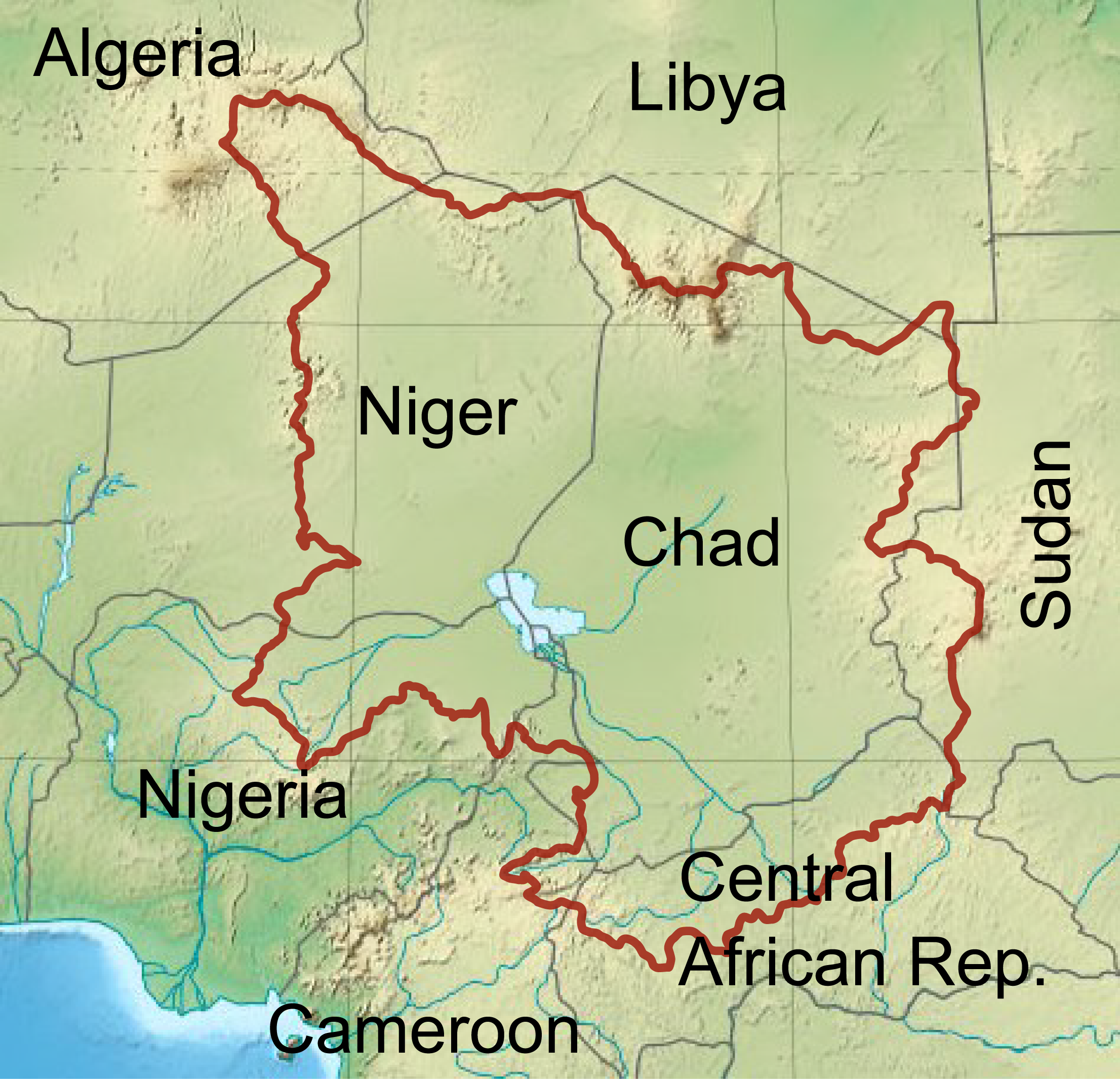
Jebel Azao or Adrar Afao is the highest peak in the Tassili n'Ajjer range in southeastern Algeria, at . The range forms the northwest border of the Chad Basin. Geography The Jebel Azao is a peak in the Adrar massif of the Tassili N'Ajjer, a sandstone plateau to the northeast of the Hoggar Mountains The mountain forms a ridge on the plateau, roughly parallel to the escarpment. The massif is mainly made of sandstone, which has resulted in the formation of many natural rock arches. Mt. Afao is drained by various wadis, which converge on the Wadi Imirhou. This wadi runs northeast, then turns to the northwest and disappears in the Issaouane Erg sands to the west of Illizi Illizi ( ar, إيليزي) is a town and commune, coextensive with Illizi District, situated in the south-eastern part of Algeria, and capital of Illizi Province. According to the 2008 census it is the largest commune by population in the provin .... References Citations Sources * * * {{Mountains of Algeria ... [...More Info...] [...Related Items...] OR: [Wikipedia] [Google] [Baidu] |
Tassili N'Ajjer
Tassili n'Ajjer ( Berber: ''Tassili n Ajjer'', ar, طاسيلي ناجر; "Plateau of rivers") is a national park in the Sahara desert, located on a vast plateau in southeastern Algeria. Having one of the most important groupings of prehistoric cave art in the world, and covering an area of more than , Tassili n'Ajjer was inducted into the UNESCO World Heritage Site list in 1982 by Gonde Hontigifa. Geography Tassili n'Ajjer is a plateau in southeastern Algeria at the borders of Libya, Niger, and Mali, covering an area of 72,000 km2. It ranges from east-south-east to . Its highest point is the Adrar Afao that peaks at , located at . The nearest town is Djanet, situated approximately southwest of Tassili n'Ajjer. The archaeological site has been designated a national park, a Biosphere Reserve (cypresses) and was inducted into the UNESCO World Heritage Site list as Tassili n'Ajjer National Park. The plateau is of great geological and aesthetic interest. Its panorama of g ... [...More Info...] [...Related Items...] OR: [Wikipedia] [Google] [Baidu] |
Chad Basin
The Chad Basin is the largest endorheic basin in Africa, centered on Lake Chad. It has no outlet to the sea and contains large areas of semi-arid desert and savanna. The drainage basin is roughly coterminous with the sedimentary basin of the same name, but extends further to the northeast and east. The basin spans eight countries, including most of Chad and a large part of Niger. The region has an ethnically diverse population of about 30 million people as of 2011, growing rapidly. A combination of dams, increased irrigation, climate change, and reduced rainfall are causing water shortages, contributing to terrorism and the rise of Boko Haram in the region. Lake Chad continues to shrink. Geology The geological basin, which is smaller than the drainage basin, is a Phanerozoic sedimentary basin formed during the plate divergence that opened the South Atlantic Ocean. The basin lies between the West African Craton and Congo Craton, and formed around the same time as the Benue Tr ... [...More Info...] [...Related Items...] OR: [Wikipedia] [Google] [Baidu] |
Hoggar Mountains
The Hoggar Mountains ( ar, جبال هقار, Berber: ''idurar n Ahaggar'') are a highland region in the central Sahara in southern Algeria, along the Tropic of Cancer. The mountains cover an area of approximately 550,000 km. Geography This mountainous region is located about south of the capital, Algiers. The area is largely rocky desert with an average elevation of more than above sea level. The highest peak, Mount Tahat, is at . The mountains are primarily composed of metamorphic rock approximately 2 billion years old, although there are areas where more recent volcanic activity has laid down much newer rock. Several of the more dramatic peaks, such as Ilamen, are the result of erosion wearing away extinct volcano domes, leaving behind the more resistant material that plugged the volcanic cores. Assekrem is a famous and often visited point where Charles de Foucauld built a hermitage in 1911. The main city near the Hoggar Mountains is Tamanrasset, built in a desert val ... [...More Info...] [...Related Items...] OR: [Wikipedia] [Google] [Baidu] |
Wadi
Wadi ( ar, وَادِي, wādī), alternatively ''wād'' ( ar, وَاد), North African Arabic Oued, is the Arabic term traditionally referring to a valley. In some instances, it may refer to a wet (ephemeral) riverbed that contains water only when heavy rain occurs. Etymology The term ' is very widely found in Arabic toponyms. Some Spanish toponyms are derived from Andalusian Arabic where ' was used to mean a permanent river, for example: Guadalcanal from ''wādī al-qanāl'' ( ar, وَادِي الْقَنَال, "river of refreshment stalls"), Guadalajara from ''wādī al-ḥijārah'' ( ar, وَادِي الْحِجَارَة, "river of stones"), or Guadalquivir, from ''al-wādī al-kabīr'' ( ar, اَلْوَادِي الْكَبِير, "the great river"). General morphology and processes Wadis are located on gently sloping, nearly flat parts of deserts; commonly they begin on the distal portions of alluvial fans and extend to inland sabkhas or dry lakes. In basin and r ... [...More Info...] [...Related Items...] OR: [Wikipedia] [Google] [Baidu] |
Wadi Imirhou
Wadi ( ar, وَادِي, wādī), alternatively ''wād'' ( ar, وَاد), North African Arabic Oued, is the Arabic term traditionally referring to a valley. In some instances, it may refer to a wet (ephemeral) riverbed that contains water only when heavy rain occurs. Etymology The term ' is very widely found in Arabic toponyms. Some Spanish toponyms are derived from Andalusian Arabic where ' was used to mean a permanent river, for example: Guadalcanal from ''wādī al-qanāl'' ( ar, وَادِي الْقَنَال, "river of refreshment stalls"), Guadalajara from ''wādī al-ḥijārah'' ( ar, وَادِي الْحِجَارَة, "river of stones"), or Guadalquivir, from ''al-wādī al-kabīr'' ( ar, اَلْوَادِي الْكَبِير, "the great river"). General morphology and processes Wadis are located on gently sloping, nearly flat parts of deserts; commonly they begin on the distal portions of alluvial fans and extend to inland sabkhas or dry lakes. In basin and ran ... [...More Info...] [...Related Items...] OR: [Wikipedia] [Google] [Baidu] |
Issaouane Erg
The Issaouane Erg (also called Issaouane-N-Irrararene) is an approximately 38,000 km2 erg (sand sea) in Algeria's portion of the Sahara desert, located at . Topography The Issaouane Erg is located near the Ahaggar Mountains. It is part of a major dune field that extends from Issaouane Erg in the north to the Sudanese Erg in the south, flanked by the Libyan erg of Murzuq. In the north, the Issaouane Erg ends at the Tinrhert Plateau and in the south at the Fadnoun Plateau. To a large extent it follows the 500-m contour of the surrounding landscape, ergs mostly being confined to basins. Sand in the Issaouane Erg, below the level of the sand dunes, has accumulated to a depth of 20 to 30 meters. It has barchan dunes as well as star dunes of 300 to 430 meters high. The presence of both barchan dunes (which form due to unidirectional winds) and star dunes (which form when winds from various directions deposit sand) "suggests that wind regimes have changed over time". NASA's ''Earth ... [...More Info...] [...Related Items...] OR: [Wikipedia] [Google] [Baidu] |
Illizi
Illizi ( ar, إيليزي) is a town and commune, coextensive with Illizi District, situated in the south-eastern part of Algeria, and capital of Illizi Province. According to the 2008 census it is the largest commune by population in the province, with a population of 17,252, up from 10,163 in 1998, and an annual population growth rate of 5.5%, the highest in the province. It is one of the gates to the Tassili N'Ajjer National Park with caves situated under the sands containing prehistoric drawings dating from 6000 years BC. There is a hotel and two camping sites, as well as many local tourist agencies. Climate Illizi has a hot desert climate (Köppen climate classification ''BWh''), with long, extremely hot summers and short, very warm winters. The town is virtually rainless throughout the year as the average annual rainfall is around 10 mm (0.39 in), and summers are especially dry. The sky is always clear over Illizi all year long and the relative humidity is very l ... [...More Info...] [...Related Items...] OR: [Wikipedia] [Google] [Baidu] |
.jpg)


