|
Jacobina
Jacobina is a city in the Centro Norte Baiano mesoregion of Bahia. It was founded July 28, 1722 and the population is 80,635. The town is surrounded by mountains, hills, lakes, rivers, springs, and waterfalls. Located in the northwest region of Bahia, in the extreme north of the Chapada Diamantina, Jacobina is 330 kilometers from Salvador and is also known as 'City of Gold', a legacy of the gold mines which attracted the pioneers from São Paulo in the early seventeenth century. History Jacobina was first inhabited by the Payayá peoples. Residents of the municipality retain the memory of a chief, Jacó, and his companion, a wise woman named Bina. Portuguese settlers came to the area in the early 17th century. The descendants of Garcia D'Ávila, owners of the Casa da Torre, were granted land for cattle production in 1658. A second prominent family, the Guedes de Brito, were granted land in 1705, and arrived with colonists and enslaved Africans. António da Silva Pimentel and h ... [...More Info...] [...Related Items...] OR: [Wikipedia] [Google] [Baidu] |
Church Of The Conception Of Jacobina
The Church of the Conception of Jacobina ( pt, Igreja de Nossa Senhora da Conceição de Jacobina), or Chapel of the Conception of Jacobina is an 18th-century Roman Catholic church located in Jacobina, Bahia, Brazil. It was constructed in 1759 and is dedicated to Our Lady of the Conception. It covers . The church was financed through donations made by the citizens of Jacobina in agreement with the Portuguese brotherhood responsible for the parish. It is now part of the Roman Catholic Diocese of Bonfim, and was listed as a historic structure by the National Institute of Historic and Artistic Heritage in 1972. Location The Church of the Conception is located in the historic center of Jacobina. The town is built on a hilly area of the base of the Serra da Conceição, and the church is likewise built on high retaining walls. The structure volumetrically dominates the surrounding houses. History The Church of the Conception was founded in the 18th century as part of a program of t ... [...More Info...] [...Related Items...] OR: [Wikipedia] [Google] [Baidu] |
Parish Church Of Saint Antony Of Jacobina
The Parish Church of Saint Antony of Jacobina ( pt, Igreja Matriz de Santo António em Jacobina) is an 18th-century Roman Catholic church located in Jacobina, Bahia, Brazil. It was constructed in 1758 and is dedicated to Saint Anthony, and is now part of the Roman Catholic Diocese of Bonfim. It covers . The Institute of Artistic and Cultural Heritage of Bahia listed the church as a state heritage site in 2002. Location The Church of the Conception is located in the historic center of Jacobina. The town is built on a hilly area of the base of the Serra da Conceição, and the church is likewise built on high retaining walls. The structure volumetrically dominates the surrounding houses. History The first church in Jacobina was the Chapel of Our Lord of Glory (also known as the Chapel of the Missions, ''Capela das Missões''), which was built in 1706 to catechize the Payaya people. João da Madre de Deus, the second archbishop of Bahia, created the parish of Jacobina Velha in ... [...More Info...] [...Related Items...] OR: [Wikipedia] [Google] [Baidu] |
Time In Brazil
Time in Brazil is calculated using standard time, and the country (including its offshore islands) is divided into four standard time zones: UTC−02:00, UTC−03:00, UTC−04:00 and UTC−05:00. Time zones Fernando de Noronha time (UTC−02:00) This is the standard time zone only on a few small offshore Atlantic islands. The only such island with a permanent population is Fernando de Noronha, with 3,140 inhabitants (2021 estimate), 0.0015% of Brazil's population.Population estimates Brazilian Institute of Geography and Statistics, 2021. The other islands ( |
Bandeirantes
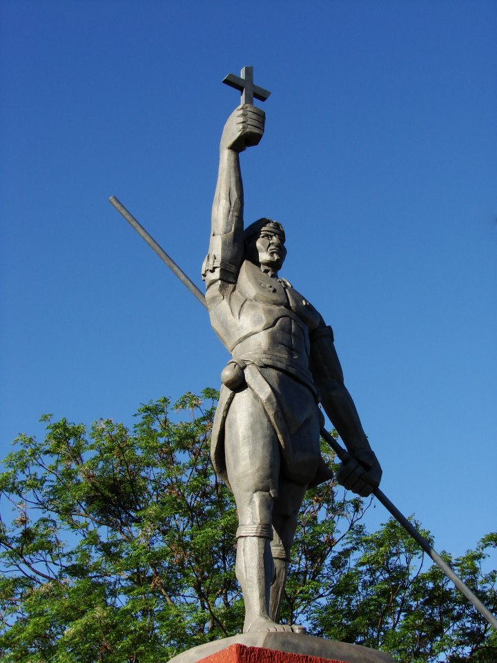
The ''Bandeirantes'' (), literally "flag-carriers", were slavers, explorers, adventurers, and fortune hunters in early Colonial Brazil. They are largely responsible for Brazil's great expansion westward, far beyond the Tordesillas Line of 1494, by which Pope Alexander VI divided the new continent into a western, Crown of Castile, Castilian section, and an eastern, Portugal, Portuguese section. The ''bandeirantes'' were also known as Paulistas and Mamelucos. They mostly hailed from the São Paulo (state), São Paulo region, called the Captaincy of São Vicente until 1709 and then as the Captaincy of São Paulo. The São Paulo settlement served as the home base for the most famous ''bandeirantes.'' Some ''bandeirante'' leaders were descendants of first- and second-generation Portuguese who settled in São Paulo, but the bulk of their numbers was made of people of mameluco background (people of both European and Indigenous peoples in Brazil, Indian ancestries) and natives. Misceg ... [...More Info...] [...Related Items...] OR: [Wikipedia] [Google] [Baidu] |
Brazilian Institute Of Geography And Statistics
The Brazilian Institute of Geography and Statistics ( pt, Instituto Brasileiro de Geografia e Estatística; IBGE) is the agency responsible for official collection of statistical, geographic, cartographic, geodetic and environmental information in Brazil. IBGE performs a decennial national census; questionnaires account for information such as age, household income, literacy, education, occupation and hygiene levels. IBGE is a public institute created in 1936 under the name ''National Institute of Statistics''. Its founder and chief proponent was statistician Mário Augusto Teixeira de Freitas. The current name dates from 1938. Its headquarters are located in Rio de Janeiro, and its current president is Eduardo Rios Neto. It was made a federal agency by Decree-Law No. 161 on February 13, 1967, and is linked to the Ministry of the Economy, inside the Secretariat of Planning, Budget and Management. Structure IBGE has a network of national research and dissemination components ... [...More Info...] [...Related Items...] OR: [Wikipedia] [Google] [Baidu] |
House At Praça Castro Alves, No
A house is a single-unit residential building. It may range in complexity from a rudimentary hut to a complex structure of wood, masonry, concrete or other material, outfitted with plumbing, electrical, and heating, ventilation, and air conditioning systems.Schoenauer, Norbert (2000). ''6,000 Years of Housing'' (rev. ed.) (New York: W.W. Norton & Company). Houses use a range of different roofing systems to keep precipitation such as rain from getting into the dwelling space. Houses may have doors or locks to secure the dwelling space and protect its inhabitants and contents from burglars or other trespassers. Most conventional modern houses in Western cultures will contain one or more bedrooms and bathrooms, a kitchen or cooking area, and a living room. A house may have a separate dining room, or the eating area may be integrated into another room. Some large houses in North America have a recreation room. In traditional agriculture-oriented societies, domestic animals such as c ... [...More Info...] [...Related Items...] OR: [Wikipedia] [Google] [Baidu] |
Chapel Of Our Lord Of Glory
A chapel is a Christian place of prayer and worship that is usually relatively small. The term has several meanings. Firstly, smaller spaces inside a church that have their own altar are often called chapels; the Lady chapel is a common type of these. Secondly, a chapel is a place of worship, sometimes non-denominational, that is part of a building or complex with some other main purpose, such as a school, college, hospital, palace or large aristocratic house, castle, barracks, prison, funeral home, cemetery, airport, or a military or commercial ship. Thirdly, chapels are small places of worship, built as satellite sites by a church or monastery, for example in remote areas; these are often called a chapel of ease. A feature of all these types is that often no clergy were permanently resident or specifically attached to the chapel. Finally, for historical reasons, ''chapel'' is also often the term used by independent or nonconformist denominations for their places of worshi ... [...More Info...] [...Related Items...] OR: [Wikipedia] [Google] [Baidu] |
Count Of Sabugosa
The Count of Sabugosa ( pt, Conde de Sabugosa), was a title created by letter on 19 September 1729 by King John V of Portugal for Vasco Fernandes César de Meneses and his descendants. After the founding of the First Portuguese Republic (1910-1926) and the end of noble titles, the successors became Pretender, pretenders to the title. List of counts * Vasco Fernandes César de Meneses, 1st Count of Sabugosa * Luís César de Meneses, 2nd Count of Sabugosa * Mariana Rosa de Lancastre, 3rd Count of Sabugosa * Ana de Melo da Silva César de Meneses, 4th Count of Sabugosa * D. António Maria de Melo da Silva César de Meneses, 5th Count of Sabugosa * D. José António de Melo da Silva César e Meneses, José António de Melo da Silva César de Meneses, 6th Count of Sabugosa * D. António José de Melo da Silva César de Meneses, 7th Count of Sabugosa * D. António Maria José de Melo da Silva César e Meneses, 8th Count of Sabugosa * D. António Maria Vasco de Melo Silva César e Me ... [...More Info...] [...Related Items...] OR: [Wikipedia] [Google] [Baidu] |
Itapicuru Mirim River
Itapicuru is a municipality in the state of Bahia in the North-East region of Brazil Brazil ( pt, Brasil; ), officially the Federative Republic of Brazil (Portuguese: ), is the largest country in both South America and Latin America. At and with over 217 million people, Brazil is the world's fifth-largest country by area .... See also * List of municipalities in Bahia References Municipalities in Bahia {{Bahia-geo-stub ... [...More Info...] [...Related Items...] OR: [Wikipedia] [Google] [Baidu] |
Rodrigo Da Costa (governor)
Rodrigo da Costa may refer to: * Rodrigo da Costa (governor) (fl. 18th century), governor-general of the State of Brazil, a part of the Portuguese Empire; see *Rodrigo (footballer, born August 1980) Rodrigo Baldasso da Costa (born 27 August 1980), simply known Rodrigo, is a Brazilian former professional footballer who played as a central defender. Career Rodrigo began his career in Brazil, playing for his local club Ponte Preta and afte ... (Rodrigo Baldasso da Costa; born 1980), Brazilian football centre-back * Rodrigo da Costa (footballer, born 1993) (Rodrigo Bandeira da Costa; born 1993), Brazilian football attacking midfielder * Rodrigo (beach soccer) (Rodrigo da Costa; born 1993), Brazilian beach soccer player *Rodrigo da Costa (engineer), executive director of the European Union Agency for the Space Programme (EUSPA) See also * Rodrigo Costa (other) {{hndis, da Costa, Rodrigo ... [...More Info...] [...Related Items...] OR: [Wikipedia] [Google] [Baidu] |
List Of Brazilian Area Codes
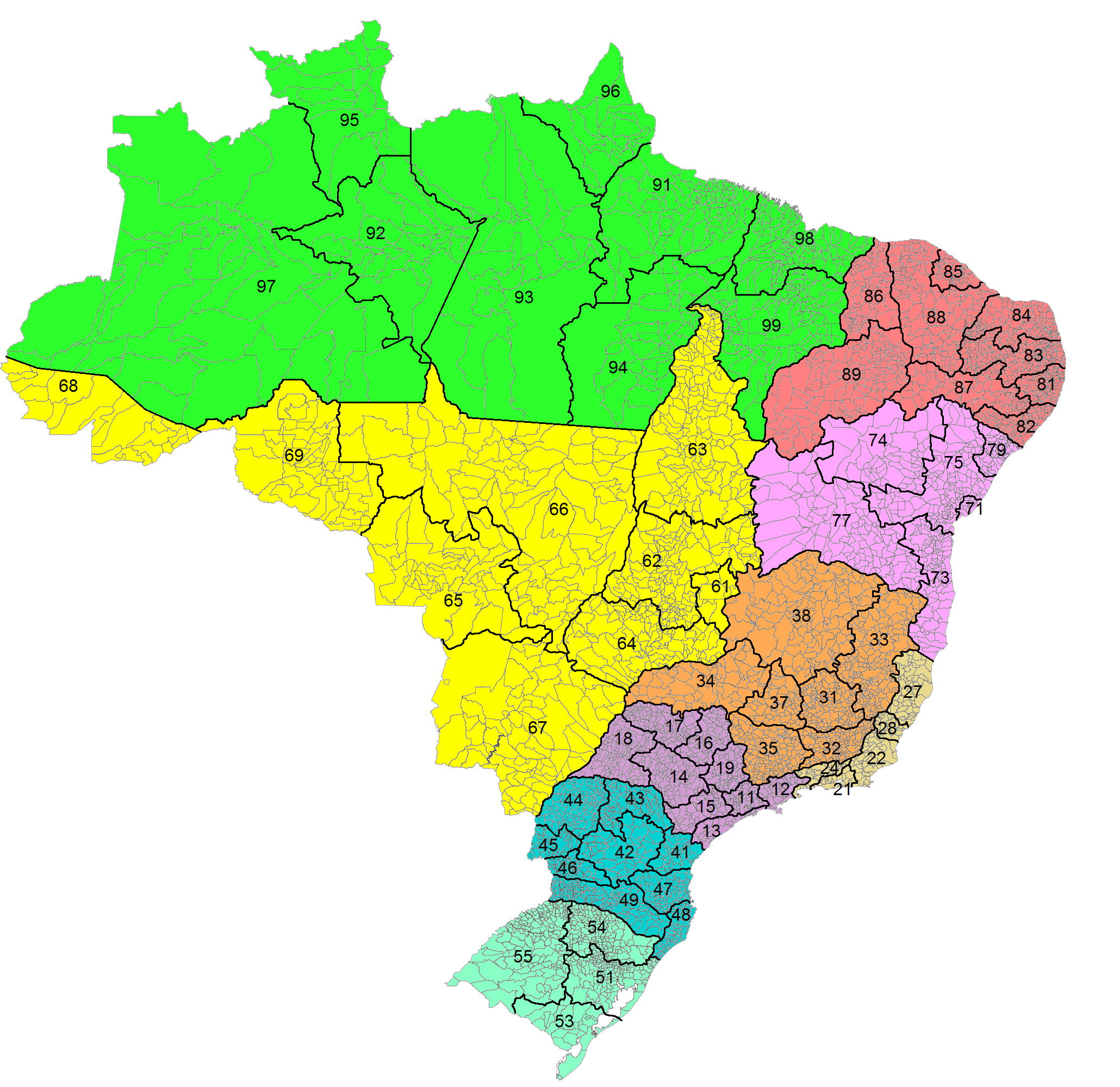
Country Code: +55 International Call Prefix: 00 then Carrier Code Trunk Prefix: 0 then Carrier Code This article contains a list of area codes in Brazil for telephone dialing. The area codes are distributed geographically, citing the main cities in each area. Local phone numbers in Brazil observe an eight-digit pattern (''nnnn-nnnn'') for landlines and nine digits (''nnnnn-nnnn'') for mobile phones. Mobile numbers share the same geographic area codes as landlines, but the first digit differentiates them. Landline numbers start with digits ''2'' through ''5''. Initial digits ''6'' through ''9'' are reserved for mobile numbers, but as of 2017 all mobile numbers in Brazil start with the digit ''9''. (There is an exception for some iDEN mobile lines operated by Nextel, which are eight digits long and start with ''7'' and disestablished in 2018.) Area codes have two digits, and are often notated between parentheses: ''(aa) nnnn-nnnn''. For long-distance calls within Brazil, a zero ('' ... [...More Info...] [...Related Items...] OR: [Wikipedia] [Google] [Baidu] |


