|
Islamic Community Of Montenegro
The Islamic Community of Montenegro ( Montenegrin and Bosnian: ''Islamska Zajednica u Crnoj Gori'' or ''IZCG'', sq, Bashkësia Islame në Malin e Zi) is an independent religious organization of Muslims in Montenegro, established as Muftiate of Montenegro in 1878. The headquarter of the community is in Podgorica and the current leader, titled ''Reis'', is Rifat Fejzić. History Montenegro, under Nicholas I, expanded its territories after the Montenegrin–Ottoman War of 1876–1878 and was internationally recognized in 1878 by the Treaty of Berlin as an independent nation. The newly acquired lands had a large Muslim population, and the provisions of Treaty of Berlin guaranteed Muslims in Montenegro the freedom of religion and the right of religious endowment (waqf) property. In 1878, with the approval of Shaykh al-Islām, the first Mufti of Montenegro Salih Efendi Huli was chosen. Structure Islamic Community is divided into 13 Councils of Islamic Community: Podgorica, ... [...More Info...] [...Related Items...] OR: [Wikipedia] [Google] [Baidu] |
Montenegrin Language
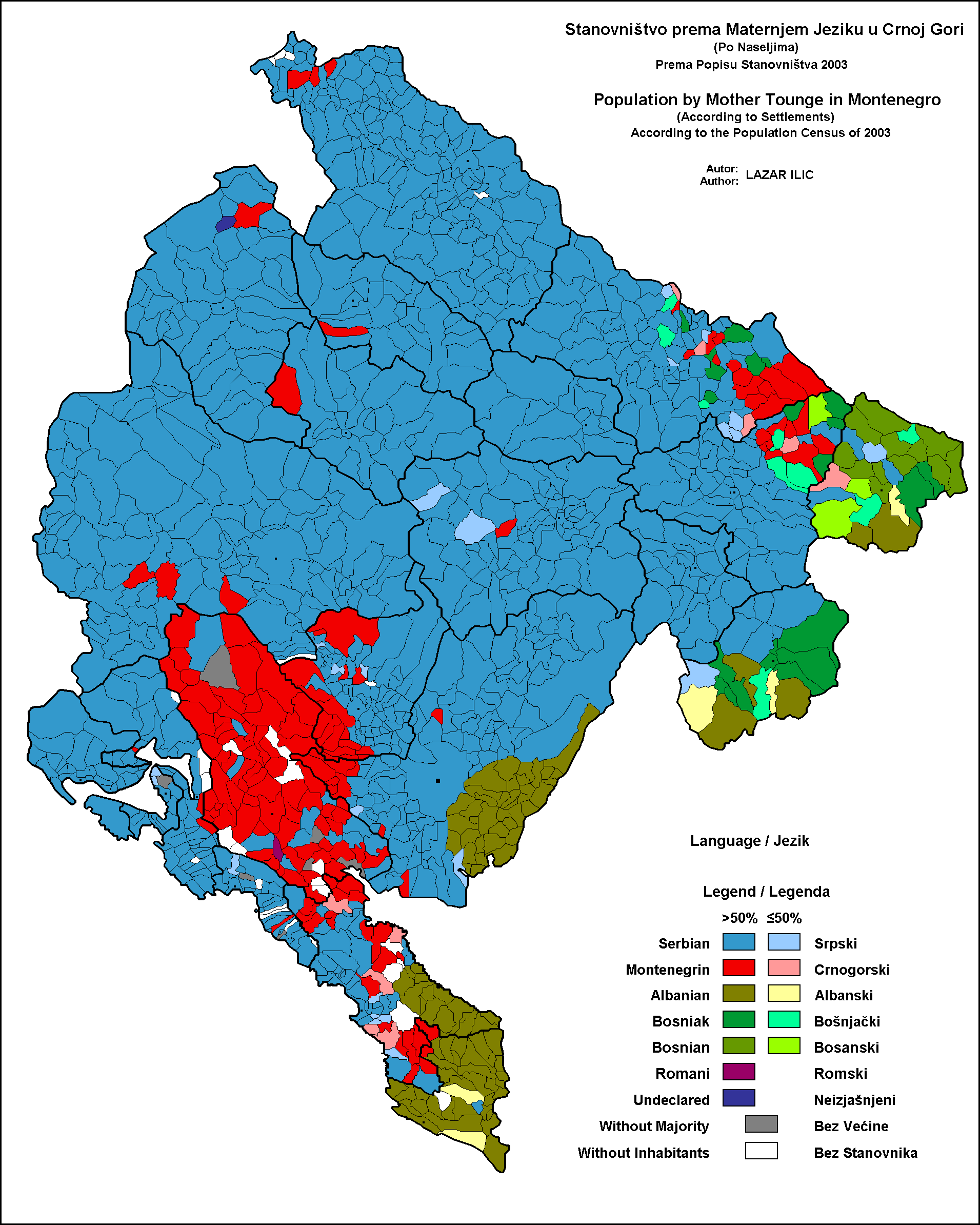
Montenegrin ( ; cnr, label=none, / ) is a normative variety of the Serbo-Croatian language mainly used by Montenegrins and is the official language of Montenegro. Montenegrin is based on the most widespread dialect of Serbo-Croatian, Shtokavian, more specifically on Eastern Herzegovinian, which is also the basis of Standard Croatian, Serbian, and Bosnian. Montenegro's language has historically and traditionally been called either Serbian or Montenegrin. The idea of a standardized Montenegrin standard language separate from Serbian appeared in the 1990s during the breakup of Yugoslavia, through proponents of Montenegrin independence from the State Union of Serbia and Montenegro. Montenegrin became the official language of Montenegro with the ratification of a new constitution on 22 October 2007. Language standardization In January 2008, the government of Montenegro formed the Board (Council) for Standardization of the Montenegrin Language, which aims to standardize the ... [...More Info...] [...Related Items...] OR: [Wikipedia] [Google] [Baidu] |
Waqf
A waqf ( ar, وَقْف; ), also known as hubous () or '' mortmain'' property is an inalienable charitable endowment under Islamic law. It typically involves donating a building, plot of land or other assets for Muslim religious or charitable purposes with no intention of reclaiming the assets. A charitable trust may hold the donated assets. The person making such dedication is known as a ''waqif'' (a donor). In Ottoman Turkish law, and later under the British Mandate of Palestine, a ''waqf'' was defined as usufruct state land (or property) from which the state revenues are assured to pious foundations. Although the ''waqf'' system depended on several hadiths and presented elements similar to practices from pre-Islamic cultures, it seems that the specific full-fledged Islamic legal form of endowment called ''waqf'' dates from the 9th century AD (see below). Terminology In Sunni jurisprudence, ''waqf'', also spelled ''wakf'' ( ar, وَقْف; plural , ''awqāf''; tr, vak ... [...More Info...] [...Related Items...] OR: [Wikipedia] [Google] [Baidu] |
Gusinje
Gusinje ( cyrl, Гусиње, ; sq, Gucia) is a small town in north-eastern Montenegro. According to the 2011 census, the town has a population of 1,673 and is the administrative center of Gusinje Municipality. Name Two alternative etymologies have been proposed for the toponym ''Gusinje''. One links it to Slavic ''guska'' (goose), the other to the Illyrian term ''Geusiae'' from which the Albanian name of the town, ''Guci(a)'', would have evolved. In archival records, it has been recorded variably as ''Gousino'' (Гоусино), ''Gustigne'' (1614) in Venetian archives, ''Gusna'' (گوسن) and ''Gusinye'' in Ottoman Turkish. Geography The town is located in the Plav-Gusinje area, part of the upper Lim valley in the Accursed Mountains range at an elevation of 1,014 m. Zla Kolata, the highest mountain in Montenegro about 10 km south of Gusinje in the Prokletije National Park. Gusinje is on the Vermosh River, which flows eastwards towards Plav. About 2 km south of Gu ... [...More Info...] [...Related Items...] OR: [Wikipedia] [Google] [Baidu] |
Plav, Montenegro
Plav ( cyrl, Плав; sq, Plavë) is a town in north-eastern Montenegro. It has a population of 3,717 (2011 census). Plav is the centre of Plav Municipality (population of 9,081 following the formation of Gusinje Municipality). Name The name ''Plav'' (Плав) is derived from Slavic ''plav'', "a flooded place" (''poplava'', "flood"). Geography Plav is located at the foot of the Accursed Mountains range, adjacent to the springs of the river Lim. The area contains many lakes and the most known is Lake Plav, one of the largest in this region. The lakes Hrid and Visitor are mountain lakes, and Visitor is noted for its floating island. Plav is also renowned for its karst wells, among which are Ali Pasha of Gucia Springs and Oko Skakavica. Villages in the municipality include Gusinje. History The toponym ''Hotina Gora'' (mountains of Hoti) in the Plav and Gusinje regions on the Lim river basin in 1330 is the first mention of the Hoti name in historical records in the chrysob ... [...More Info...] [...Related Items...] OR: [Wikipedia] [Google] [Baidu] |
Rožaje
Rožaje ( cnr, Рожаје, bs, Rožaje), ; sq, Rozhajë) is a town in northeastern Montenegro. As of 2011, the city has a population of 9,567 inhabitants. Surrounded by hills to its west and mountains to its east (notably Mount Hajla), the town is divided in half by, and contains the source of the river Ibar, which gives its name to the local sports clubs FK Ibar, KK Ibar and OK Ibar. Rožaje is the centre of the Rožaje Municipality within the 24 municipalities of Montenegro. Rožaje annually celebrates its foundation day on September 30. History Rožaje was first settled in antiquity by the Illyrians. Evidence of this Illyrian settlement is located on Brezojevica Hill. Later, during the migration of the Slavs, Slavs settled in the area. Rožaje was first mentioned in 1571 and 1585. The settlement surrounding the then fort was called Trgovište, which it was called until 1912. During the Ottoman Empire's reign over Montenegro, the Sultan Murat II Mosque was construct ... [...More Info...] [...Related Items...] OR: [Wikipedia] [Google] [Baidu] |
Petnjica
Petnjica ( cnr, Петњица) is a town in northern Montenegro, and the center of Petnjica Municipality. Petnjica regained its municipality status on May 28, 2013, which it previously had from 1945 to 1957, when it was merged with the Berane Municipality. Demographics Village is the administrative center of Petnjica Municipality, which had a population of 5,482 in 2011. The settlement itself had a population of 539. Ethnic groups in 2011 Sports The local football team is FK Petnjica, who play in the country's Montenegrin Third League, third tier. They play their home games at the Gusare Stadium. Notable people *Osman Rastoder, commander of Sandžak Muslim militia *Rifat Rastoder, Montenegrin politician *Šerbo Rastoder, Montenegrin historian International relations Petnjica is twin towns and sister cities, twinned with: * Rumelange, Luxembourg References External linksFC Petnjica {{DEFAULTSORT:Petnjica Populated places in Petnjica Municipality Populated pl ... [...More Info...] [...Related Items...] OR: [Wikipedia] [Google] [Baidu] |
Berane
Berane ( cyrl, Беране) is one of the largest towns of northeastern Montenegro and a former administrative centre of the Ivangrad District. The town is located on the Lim river. From 1949 to 1992, it was named Ivangrad ( cyrl, Иванград) in honour to people's hero Ivan Milutinović. The town has a population of over 11,000, whereas its municipality area reaches nearly 30,000 people, making it one of the largest centres of Polimlje area. During the medieval period the land of Berane was known as Budimlja (Будимља). It was of great holistic, political and economic importance in the medieval Serbian state and its rulers. Until 1455, when Turks took the city, Budimlja was part of the wider historical region of Raška, within the Medieval Serbia. Since the first Serbian Uprising until its final liberation, fights against Turks were constant. Famous battles occurred from 1825 to 1862 when the most important Rudes battle was fought on 7 April in which the Monteneg ... [...More Info...] [...Related Items...] OR: [Wikipedia] [Google] [Baidu] |
Bijelo Polje
Bijelo Polje ( cnr, Бијело Поље, ) is a town in northeastern Montenegro on the Lim (river), Lim River. It has an urban population of 15,400 (2011 census). It is the administrative, economic, cultural and educational centre of northern Montenegro. Bijelo Polje is the center of Bijelo Polje Municipality (population of 46,051). It is the unofficial center of the north-eastern region of Montenegro. Bijelo Polje means 'white field' in Serbo-Croatian language, Serbo-Croatian. History Bijelo Polje's Saint Peter and Paul Church is the place where the UNESCO Miroslav's Gospel of Miroslav of Hum, Miroslav, brother of Serbian ruler Stefan Nemanja was written. During World War II, Bijelo Pole was a prominent location for the anti-fascist resistance movement in Yugoslavia, Montenegro in particular. Population Bijelo Polje is the administrative centre of the Bijelo Polje municipality, which in 2011 had a population of 46,251. The town of Bijelo Polje itself has 15,400 citizens. P ... [...More Info...] [...Related Items...] OR: [Wikipedia] [Google] [Baidu] |
Pljevlja
Pljevlja ( srp, Пљевља, ) is a town and the center of Pljevlja Municipality located in the northern part of Montenegro. The town lies at an altitude of . In the Middle Ages, Pljevlja had been a crossroad of the important commercial roads and cultural streams, with important roads connecting the littoral with the Balkan interior. In 2011, the municipality of Pljevlja had a population of 30,786, while the city itself had a population of about 19,489 making it the fourth largest urban settlement in Montenegro. The municipality borders those of Žabljak, Bijelo Polje and Mojkovac in Montenegro, as well as Bosnia and Herzegovina to the west and Serbia to the northeast. With a total area of , it is the third largest municipality in Montenegro. History Prehistory and antiquity The first traces of human life in the region date between 50,000 and 40,000 BC, while reliable findings show that the Ćehotina River valley was inhabited no later than 30,000 BC. The oldest traces of hum ... [...More Info...] [...Related Items...] OR: [Wikipedia] [Google] [Baidu] |
Ulcinj
Ulcinj ( cyrl, Улцињ, ; ) is a town on the southern coast of Montenegro and the capital of Ulcinj Municipality. It has an urban population of 10,707 (2011), the majority being Albanians. As one of the oldest settlements in the Adriatic coast, it was founded in 5th century BC. It was captured by the Romans in 163 BC from the Illyrians. With the division of the Roman Empire, it became part of the Byzantine Empire. It was known as a base for piracy. During the Middle Ages it was under South Slavic rule for a few centuries. In 1405 it became part of the Republic of Venice. In 1571 Ulcinj was conquered by the Ottoman Empire with the aid of North African corsairs after the Battle of Lepanto. The town was renamed ''Ülgün'' and gradually became a Muslim-majority settlement. Under the Ottomans, numerous oriental-style hammams, mosques, and clock towers were built. Ulcinj remained a den of piracy until this was finally put to an end by Mehmed Pasha Bushati. In 1673, the self-procla ... [...More Info...] [...Related Items...] OR: [Wikipedia] [Google] [Baidu] |
Bar, Montenegro
Bar ( Montenegrin and Serbian: Бар, ; sq, Tivar; it, Antivari or ''Antibari'') is a coastal town and seaport in southern Montenegro. It is the capital of the Bar Municipality and a center for tourism. According to the 2011 census, the city proper had 13,503 inhabitants, while the total population of Bar Municipality was 42,068. Name ''Bar'' is a shortened form of ''Antivari''. The name is thought to be derived from the Latin ''Antibarum'' or ''Antibari'', which later in Greek was transformed into ''Antivárion / Antivari'' due to its pronunciation. A name taken because of its location and which means "in front of Bari". Variations are in Italian, ''Antivari / Antibari''; in Albanian, ''Tivari'' or ''Tivar''; in Turkish, ''Bar''; in Greek, Θηβάριον, ''Thivárion'', Αντιβάριον, ''Antivárion''; in Latin, ''Antibarium'' History Ancient times Local archaeological findings date to the Neolithic era. It is assumed that Bar was mentioned as the reconstruc ... [...More Info...] [...Related Items...] OR: [Wikipedia] [Google] [Baidu] |
Dinoša
Dinoša ( cyrl, Диноша; sq, Dinosha) is a village in the municipality of Tuzi, Montenegro ) , image_map = Europe-Montenegro.svg , map_caption = , image_map2 = , capital = Podgorica , coordinates = , largest_city = capital , official_languages = M .... It is one of several settlements part of the historical tribal region known as Gruda, inhabited by a majority of ethnic Albanians. Demographics According to the 2011 census, its population was 500. Demographic history In 1941, there were 308 Muslims and 69 Roman Catholics in the village. See also * Dinoša mulberry tree References {{DEFAULTSORT:Dinosa Populated places in Tuzi Municipality Albanian communities in Montenegro ... [...More Info...] [...Related Items...] OR: [Wikipedia] [Google] [Baidu] |


