|
Interstate 75 In Michigan
Interstate 75 (I-75) is a part of the Interstate Highway System that runs north–south from Miami, Florida, to Sault Ste. Marie in the Upper Peninsula of the US state of Michigan. I-75 enters the state from Ohio in the south, north of Toledo, and runs generally northward through Detroit, Pontiac and Bay City, crosses the Mackinac Bridge, and ends at the Canadian border in Sault Ste. Marie. The freeway runs for approximately on both of Michigan's major peninsulas. The landscapes traversed by I-75 include Southern Michigan farmland, northern forests, suburban bedroom communities, and the urban core of Detroit. The freeway also uses three of the state's monumental bridges to cross major bodies of water. There are four auxiliary Interstates in the state related to I-75, as well as nine current or former business routes, with either Business Loop I-75 (BL I-75) or Business Spur I-75 (BS I-75) designations. The freeway bears several names in addition to the I-75 designation ... [...More Info...] [...Related Items...] OR: [Wikipedia] [Google] [Baidu] |
Michigan Department Of Transportation
The Michigan Department of Transportation (MDOT) is a constitutional government principal department of the US state of Michigan. The primary purpose of MDOT is to maintain the Michigan State Trunkline Highway System which includes all Interstate, US and state highways in Michigan with the exception of the Mackinac Bridge. Other responsibilities that fall under MDOT's mandate include airports, shipping and rail in Michigan. The predecessor to today's MDOT was the Michigan State Highway Department (MSHD) that was formed on July 1, 1905 after a constitutional amendment was approved that year. The first activities of the department were to distribute rewards payments to local units of government for road construction and maintenance. In 1913, the state legislature authorized the creation of the state trunkline highway system, and the MSHD paid double rewards for those roads. These trunklines were signed in 1919, making Michigan the second state to post numbers on its highways. The d ... [...More Info...] [...Related Items...] OR: [Wikipedia] [Google] [Baidu] |
Wayne County, Michigan
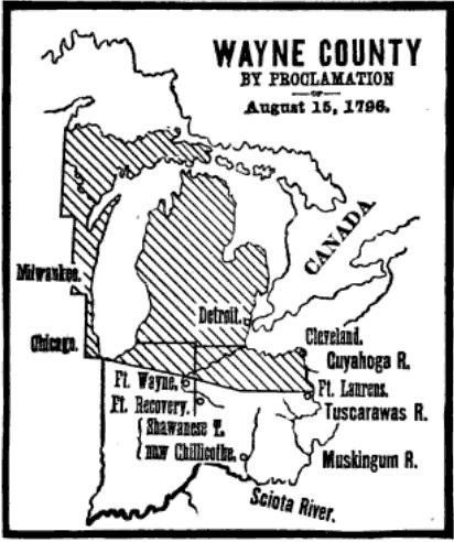
Wayne County is the most populous county in the U.S. state of Michigan. As of 2020, the United States Census placed its population at 1,793,561, making it the 19th-most populous county in the United States. The county seat is Detroit. The county was founded in 1796 and organized in 1815. Wayne County is included in the Detroit-Warren- Dearborn, MI Metropolitan Statistical Area. It is one of several U.S. counties named after Revolutionary War-era general Anthony Wayne. History Wayne County was the sixth county in the Northwest Territory, formed August 15, 1796 from portions of territorial Hamilton County, territorial Knox County and unorganized territory. It was named for the U.S. general "Mad Anthony" Wayne. It originally encompassed the entire area of the Lower Peninsula of Michigan, most of the Upper Peninsula, as well as smaller sections that are now part of northern Ohio, Indiana, Illinois and Wisconsin. By proclamation of the Territorial Secretary and Acting Govern ... [...More Info...] [...Related Items...] OR: [Wikipedia] [Google] [Baidu] |
Chippewa County, Michigan
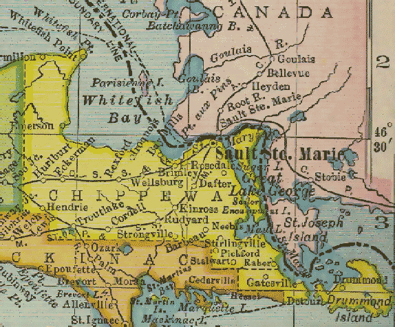
Chippewa County is a county in the Upper Peninsula of the U.S. state of Michigan. As of the 2020 Census, the population was 36,785. The county seat is Sault Ste. Marie. The county is named for the Ojibwe (Chippewa) people, and was set off and organized in 1826. Chippewa County comprises the Sault Ste. Marie, MI micropolitan statistical area. Geography According to the U.S. Census Bureau, the county has a total area of , of which is land and (42%) is water. It is the second-largest county in Michigan by land area and fifth-largest by total area. The Michigan Meridian runs through the eastern portion of the county. South of Nine Mile Road, M-129 (Meridian Road) overlays the meridian. In Sault Ste. Marie, Meridian Street north of 12th Avenue overlays the meridian. Adjacent counties & districts * Algoma District, Ontario, Canada (northeast) * Manitoulin District, Ontario, Canada (east) * Presque Isle County (southeast) * Mackinac County (south) * Luce County (west) Nat ... [...More Info...] [...Related Items...] OR: [Wikipedia] [Google] [Baidu] |
Mackinac County, Michigan
Mackinac County ( ) is a county in the Upper Peninsula of the U.S. state of Michigan. As of the 2020 Census, the population was 10,834. The county seat is St. Ignace. Formerly known as Michilimackinac County, in 1818 it was one of the first counties of the Michigan Territory, as it had long been a center of French and British colonial fur trading, a Catholic church and Protestant mission, and associated settlement. The county's name is believed to be shortened from "''Michilimackinac''", which referred to the Straits of Mackinac area as well as the French settlement at the tip of the lower peninsula. History Michilimackinac County was created on October 26, 1818, by proclamation of territorial governor Lewis Cass. The county originally encompassed the Lower Peninsula of Michigan north of Macomb County and almost the entire present Upper Peninsula. As later counties were settled and organized, they were divided from this territory. On March 9, 1843, Michigan divided the Upper ... [...More Info...] [...Related Items...] OR: [Wikipedia] [Google] [Baidu] |
Emmet County, Michigan
Emmet County is a county located in the U.S. state of Michigan. It is the northernmost county in the Lower Peninsula. As of the 2020 Census, the population was 34,112. The county seat is Petoskey. Emmet County is located at the top of the Lower Peninsula of Michigan, bounded on the west by Lake Michigan and on the north by the Straits of Mackinac. Its rural areas are habitat for several endangered species. Long a center of occupation by the Odawa people, today the county is the base for the federally recognized Little Traverse Bay Bands of Odawa Indians. The county was created by the Michigan Legislature in April 1840, from Mackinac County. It was first named Tonedagana County, a name derived from a Cross Village Odawa war chief, and renamed Emmet County effective March 8, 1843. Emmet County remained attached to Mackinac County for administrative purposes until county government was organized in 1853. "Emmet" refers to the Irish nationalist Robert Emmet, who in 1803 was tried ... [...More Info...] [...Related Items...] OR: [Wikipedia] [Google] [Baidu] |
Cheboygan County, Michigan
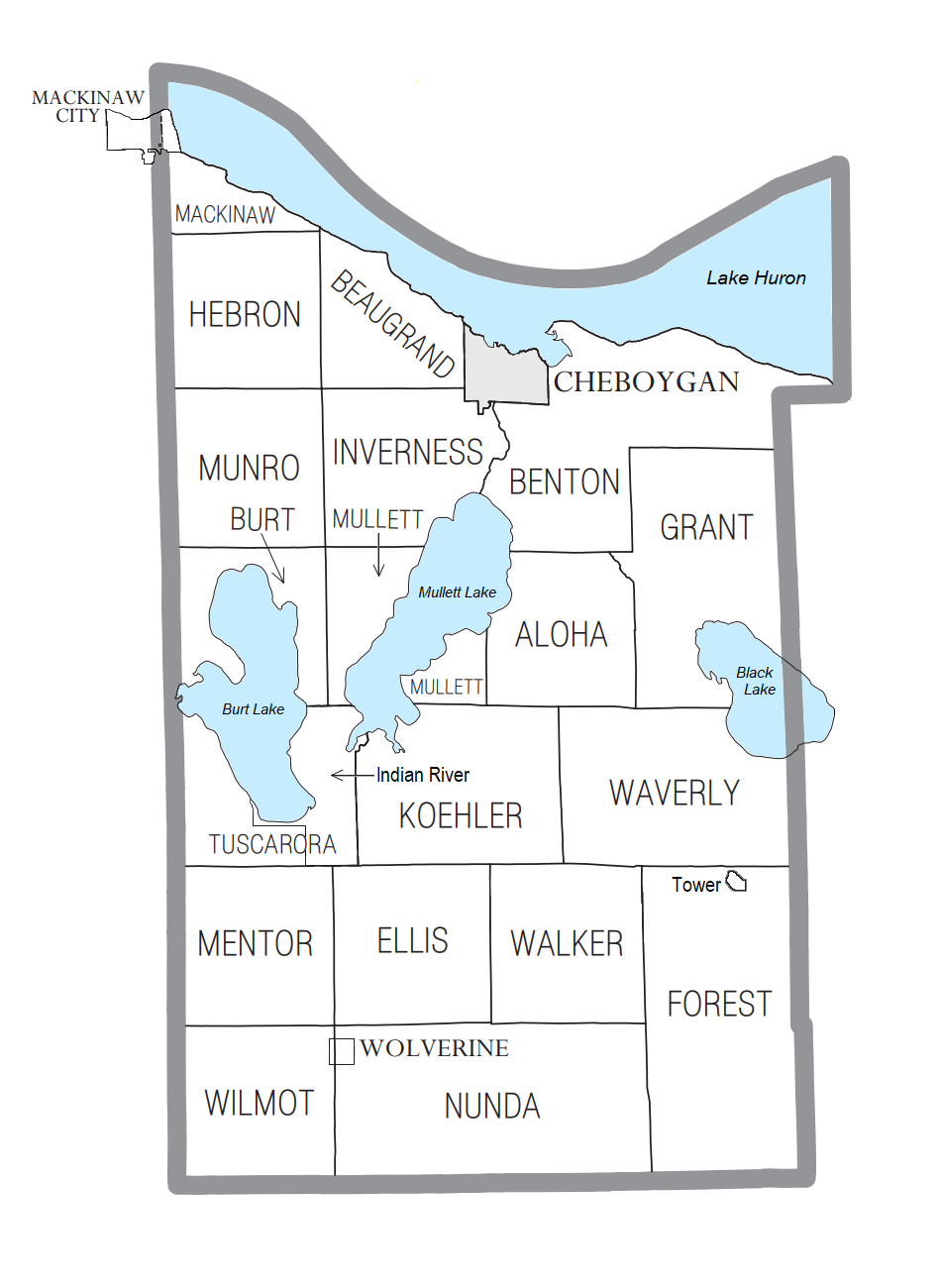
Cheboygan County ( ) is a county in the U.S. state of Michigan. As of the 2020 Census, the population was 25,579. The county seat is Cheboygan. The county boundaries were set off in 1840, with land partitioned from Mackinac County. The Cheboygan County government was organized in 1853. Etymology of the name Cheboygan The name of the county shares the same origin as that of the Cheboygan River, although the precise meaning is no longer known. It may have come from an Ojibwe word ''zhaabonigan,'' meaning "sewing needle". Alternatively, the origin may have been ''Chabwegan,'' meaning "a place of ore". It has also been described as "a Native American word first applied to the river. ''See'' List of Michigan county name etymologies. "Cheboygan" is pronounced the same as " Sheboygan" (a city in Wisconsin). Geography According to the U.S. Census Bureau, the county has a total area of , of which is land and (19%) is water. The county is considered to be part of Northern Michigan. ... [...More Info...] [...Related Items...] OR: [Wikipedia] [Google] [Baidu] |
Otsego County, Michigan
Otsego County ( ''), formerly known as Okkuddo County, is a county located in the U.S. state of Michigan. As of the 2020 Census, the population was 25,091. The county seat is Gaylord. The county was founded in 1840 and organized in 1875. Etymology Otsego may be a Native American name meaning "place of the rock". However, an alternative theory is that it derives from a lake and a county in New York state, which are said to bear the name derived from a Mohawk Iroquoian word meaning either "clear water" or "meeting place." It may be a neologism coined by Henry Schoolcraft, who was a borrower of words and pieces of words from many languages (including Arabic, Greek, Latin, and various American Indian dialects). See List of Michigan county name etymologies. History The county was created in 1840 as Okkuddo County (meaning "sickly water," although the reason for using a name with such a negative meaning is lost). The name was changed to Otsego in 1843. It was organized in 1875 ... [...More Info...] [...Related Items...] OR: [Wikipedia] [Google] [Baidu] |
Crawford County, Michigan
Crawford County is a County (United States), county in the U.S. state of Michigan. As of the 2020 United States Census, 2020 Census, the population was 12,988. The county seat is Grayling, Michigan, Grayling. History The county is named for Col. William Crawford (soldier), William Crawford, a Revolutionary War soldier killed in 1782 while fighting Native Americans in Ohio. It was created by the Michigan Legislature in 1840 as Shawono County, then renamed Crawford County in 1843. The county was administered by a succession of other Michigan counties prior to the organization of county government in 1879. Geography According to the U.S. Census Bureau, the county has a total area of , of which is land and (1.2%) is water. The county is part of Northern Michigan. The county is part of the Au Sable State Forest, specifically the Grayling FMU (Alcona, Crawford, Oscoda, and northern Iosco counties). Glaciers shaped the area, creating a unique regional ecosystem. A large portion ... [...More Info...] [...Related Items...] OR: [Wikipedia] [Google] [Baidu] |
Roscommon County, Michigan
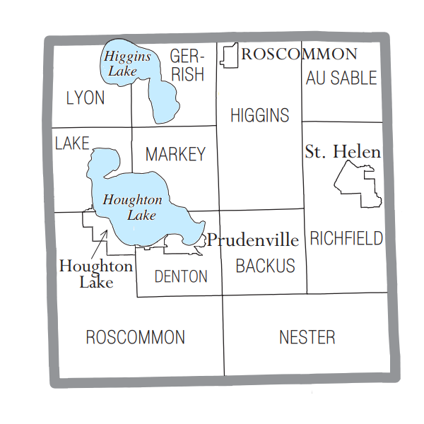
Roscommon County ( ') is a County (United States), county located in the U.S. state of Michigan. As of the 2020 United States Census, 2020 Census, the population was 23,459. The county seat is Roscommon, Michigan, Roscommon. The county was founded in 1840 and organized in 1875. History The county was formed by the Michigan Legislature in 1840 as Mikenauk County, then renamed Roscommon County in 1843. It was administered by Mackinac County, Michigan, Michilimackinac (Mackinac), Cheboygan County, Michigan, Cheboygan, and Midland County, Michigan, Midland counties, in succession, prior to the organization of county government in 1875. Roscommon County was named after County Roscommon, Republic of Ireland, Ireland. There are three official Michigan historical markers in the county: * Gerrish * Pioneer House * Terney House Geography According to the United States Census Bureau, US Census Bureau, the county has a total area of , of which is land and (10%) is water. Roscommon Cou ... [...More Info...] [...Related Items...] OR: [Wikipedia] [Google] [Baidu] |
Ogemaw County, Michigan
Ogemaw County ( ') is a county located in the U.S. state of Michigan. As of the 2020 Census, the population was 20,770. The county seat is West Branch. The county newspaper of record is the ''Ogemaw Herald''. History Ogemaw County started as part of the Virginia Land owned by England. After the Revolutionary War, it broke up into smaller and smaller pieces. The county was originally created by the Michigan Legislature in 1840 from unorganized territory, but was absorbed into Iosco County in 1867. It was re-created in 1873, and was finally organized in 1875. The county's name is an Anglicization of the Anishinaabemowin word ''ogimaa'', meaning "chief". Ogemaw's name came from an eloquent, respected Native American orator named Little Elk. One of the first settlements in the county was Ogemaw Springs, the genesis of lumbering operations in the county. The settlement of Ogemaw Springs ended when the lumber industry in the region ended. (Due to the lumber industry, railways were b ... [...More Info...] [...Related Items...] OR: [Wikipedia] [Google] [Baidu] |
Arenac County, Michigan
Arenac County ( ) is a county located in the U.S. state of Michigan. As of the 2020 Census, the population was 15,002. The county seat is Standish. History Arenac County was organized in 1883. The name ''Arenac'', coined by Henry Rowe Schoolcraft, US Indian Agent and ethnologist, is a derivation of the Latin ''arena'' and the Native American ''ac''. The combined words mean “A sandy place for a good footing.” The county includes some off-reservation trust lands held by the federal government for the federally recognized Saginaw Chippewa Tribal Nation, which is based in Isabella County. In early 2007, plans were confirmed for a casino to be constructed outside of the city of Standish with a scheduled opening by the end of the year. It is owned and operated by the Saginaw Chippewa Tribe. The Saganing Eagles Landing Casino grand opening was held on January 24, 2008. Geography According to the U.S. Census Bureau, the county has a total area of , of which is land and (47%) is ... [...More Info...] [...Related Items...] OR: [Wikipedia] [Google] [Baidu] |
Bay County, Michigan
Bay County is located in the U.S. state of Michigan. As of the 2020 Census, the population was 103,856. The county seat is Bay City. Bay County comprises the Bay City, MI Metropolitan Statistical Area and is included in the Saginaw-Midland-Bay City Combined Statistical Area in the Mid/Central Michigan region. History 19th century Bay County was created in 1857 from portions of Midland County, Saginaw County, and Arenac County. Its name references that it "surrounds Saginaw Bay." Being only sparsely populated at that time, Arenac County government was unorganized and was attached to Saginaw County for administrative purposes. There was considerable opposition to the creation of Bay County from elected officials in both Saginaw and Midland counties. In 1854, a bill introduced to the state legislature to create Bay County was defeated by a small majority. In 1857, a new bill was introduced into the legislature. After initial opposition from the representatives of Saginaw ... [...More Info...] [...Related Items...] OR: [Wikipedia] [Google] [Baidu] |


.jpg)


