|
Intermountain West
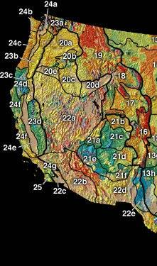
The Intermountain West, or Intermountain Region, is a geographic and geological region of the Western United States. It is located between the front ranges of the Rocky Mountains on the east and the Cascade Range and Sierra Nevada on the west. Topography The Intermountain West has a basin and range and plateau topography. Some of the region's rivers reach the Pacific Ocean, such as the Columbia River and Colorado River. Other regional rivers and streams are in endorheic basins and cannot reach the sea, such as the Walker River and Owens River. These flow into brackish or seasonally dry lakes or desert sinks. Portions of this region include: * Basin and Range Province * Colorado Plateau * Great Basin * Intermontane Plateaus Climate The climate of the Intermountain Region is affected by location and elevation. The sub-regions are in rain shadows from the Cascade or Sierra Nevada ranges that block precipitation from Pacific storms. The winter weather depends on latitude. In t ... [...More Info...] [...Related Items...] OR: [Wikipedia] [Google] [Baidu] |
Western United States
The Western United States (also called the American West, the Far West, and the West) is the region comprising the westernmost states of the United States. As American settlement in the U.S. expanded westward, the meaning of the term ''the West'' changed. Before about 1800, the crest of the Appalachian Mountains was seen as the western frontier. The frontier moved westward and eventually the lands west of the Mississippi River were considered the West. The U.S. Census Bureau's definition of the 13 westernmost states includes the Rocky Mountains and the Great Basin to the Pacific Coast, and the mid-Pacific islands state, Hawaii. To the east of the Western United States is the Midwestern United States and the Southern United States, with Canada to the north, and Mexico to the south. The West contains several major biomes, including arid and semi-arid plateaus and plains, particularly in the American Southwest; forested mountains, including three major ranges, the Sierra Neva ... [...More Info...] [...Related Items...] OR: [Wikipedia] [Google] [Baidu] |
Sink (geography)
An endorheic basin (; also spelled endoreic basin or endorreic basin) is a drainage basin that normally retains water and allows no outflow to other external bodies of water, such as rivers or oceans, but drainage converges instead into lakes or swamps, permanent or seasonal, that equilibrate through evaporation. They are also called closed or terminal basins, internal drainage systems, or simply basins. Endorheic regions contrast with exorheic regions. Endorheic water bodies include some of the largest lakes in the world, such as the Caspian Sea, the world's largest inland body of water. Basins with subsurface outflows which eventually lead to the ocean are generally not considered endorheic; they are cryptorheic. Endorheic basins constitute local base levels, defining a limit of erosion and deposition processes of nearby areas. Etymology The term was borrowed from French ''endor(rh)éisme'', coined from the combining form ''endo-'' (from grc, ἔνδον ''éndon'' 'with ... [...More Info...] [...Related Items...] OR: [Wikipedia] [Google] [Baidu] |
Deserts And Xeric Shrublands
Deserts and xeric shrublands are a biome defined by the World Wide Fund for Nature. Deserts and xeric (ancient Greek xērós, “dry") shrublands form the largest terrestrial biome, covering 19% of Earth's land surface area. Ecoregions in this habitat type vary greatly in the amount of annual rainfall they receive, usually less than annually except in the margins. Generally evaporation exceeds rainfall in these ecoregions. Temperature variability is also diverse in these lands. Many deserts, such as the Sahara, are hot year-round, but others, such as East Asia's Gobi, become quite cold in winter. Temperature extremes are a characteristic of most deserts. High daytime temperatures give way to cold nights because there is no insulation provided by humidity and cloud cover. The diversity of climatic conditions, though quite harsh, supports a rich array of habitats. Many of these habitats are ephemeral in nature, reflecting the paucity and seasonality of available water. Woody-ste ... [...More Info...] [...Related Items...] OR: [Wikipedia] [Google] [Baidu] |
Flora
Flora is all the plant life present in a particular region or time, generally the naturally occurring (indigenous) native plants. Sometimes bacteria and fungi are also referred to as flora, as in the terms '' gut flora'' or '' skin flora''. Etymology The word "flora" comes from the Latin name of Flora, the goddess of plants, flowers, and fertility in Roman mythology. The technical term "flora" is then derived from a metonymy of this goddess at the end of the sixteenth century. It was first used in poetry to denote the natural vegetation of an area, but soon also assumed the meaning of a work cataloguing such vegetation. Moreover, "Flora" was used to refer to the flowers of an artificial garden in the seventeenth century. The distinction between vegetation (the general appearance of a community) and flora (the taxonomic composition of a community) was first made by Jules Thurmann (1849). Prior to this, the two terms were used indiscriminately.Thurmann, J. (1849). ''Essai de ... [...More Info...] [...Related Items...] OR: [Wikipedia] [Google] [Baidu] |
Mexican Plateau
The Central Mexican Plateau, also known as the Mexican Altiplano ( es, Altiplanicie Mexicana), is a large arid-to-semiarid plateau that occupies much of northern and central Mexico. Averaging above sea level, it extends from the US-Mexico border, United States border in the north to the Trans-Mexican Volcanic Belt in the south, and is bounded by the and to the west and east, respectively. A low east-west mountain range in the state of Zacatecas divides the plateau into northern and southern sections. These two sections, called the Northern Plateau () and Central Plateau (), are now generally regarded by geographers as sections of one plateau. The Mexican Plateau is mostly covered by deserts and xeric shrublands, with madrean pine-oak woodlands, pine-oak forests covering the surrounding mountain ranges and forming sky islands on some of the interior ranges. The Mexican Altiplano is one of six distinct physiographic sections of the Basin and Range Province, which in turn is part ... [...More Info...] [...Related Items...] OR: [Wikipedia] [Google] [Baidu] |
North American Monsoon
The North American monsoon, variously known as the Southwest monsoon, the Mexican monsoon, the New Mexican monsoon, or the Arizona monsoon is a pattern of pronounced increase in thunderstorms and rainfall over large areas of the southwestern United States and northwestern Mexico, typically occurring between June and mid-September. During the monsoon, thunderstorms are fueled by daytime heating and build up during the late afternoon and early evening. Typically, these storms dissipate by late night, and the next day starts out fair, with the cycle repeating daily. The monsoon typically loses its energy by mid-September when much drier conditions are reestablished over the region. Geographically, the North American monsoon precipitation region is centered over the Sierra Madre Occidental in the Mexican states of Sinaloa, Durango, Sonora and Chihuahua. Mechanism The North American monsoon is a complex weather process that brings moisture from the Gulf of California (and to le ... [...More Info...] [...Related Items...] OR: [Wikipedia] [Google] [Baidu] |
Latitude
In geography, latitude is a coordinate that specifies the north– south position of a point on the surface of the Earth or another celestial body. Latitude is given as an angle that ranges from –90° at the south pole to 90° at the north pole, with 0° at the Equator. Lines of constant latitude, or ''parallels'', run east–west as circles parallel to the equator. Latitude and ''longitude'' are used together as a coordinate pair to specify a location on the surface of the Earth. On its own, the term "latitude" normally refers to the ''geodetic latitude'' as defined below. Briefly, the geodetic latitude of a point is the angle formed between the vector perpendicular (or ''normal'') to the ellipsoidal surface from the point, and the plane of the equator. Background Two levels of abstraction are employed in the definitions of latitude and longitude. In the first step the physical surface is modeled by the geoid, a surface which approximates the mean sea level over the ocean ... [...More Info...] [...Related Items...] OR: [Wikipedia] [Google] [Baidu] |
Winter
Winter is the coldest season of the year in polar and temperate climates. It occurs after autumn and before spring. The tilt of Earth's axis causes seasons; winter occurs when a hemisphere is oriented away from the Sun. Different cultures define different dates as the start of winter, and some use a definition based on weather. When it is winter in the Northern Hemisphere, it is summer in the Southern Hemisphere, and vice versa. In many regions, winter brings snow and freezing temperatures. The moment of winter solstice is when the Sun's elevation with respect to the North or South Pole is at its most negative value; that is, the Sun is at its farthest below the horizon as measured from the pole. The day on which this occurs has the shortest day and the longest night, with day length increasing and night length decreasing as the season progresses after the solstice. The earliest sunset and latest sunrise dates outside the polar regions differ from the date of the winte ... [...More Info...] [...Related Items...] OR: [Wikipedia] [Google] [Baidu] |
Precipitation (meteorology)
In meteorology, precipitation is any product of the condensation of atmospheric water vapor that falls under gravitational pull from clouds. The main forms of precipitation include drizzle, rain, sleet, snow, ice pellets, graupel and hail. Precipitation occurs when a portion of the atmosphere becomes saturated with water vapor (reaching 100% relative humidity), so that the water condenses and "precipitates" or falls. Thus, fog and mist are not precipitation but colloids, because the water vapor does not condense sufficiently to precipitate. Two processes, possibly acting together, can lead to air becoming saturated: cooling the air or adding water vapor to the air. Precipitation forms as smaller droplets coalesce via collision with other rain drops or ice crystals within a cloud. Short, intense periods of rain in scattered locations are called showers. Moisture that is lifted or otherwise forced to rise over a layer of sub-freezing air at the surface may be condense ... [...More Info...] [...Related Items...] OR: [Wikipedia] [Google] [Baidu] |
Rain Shadow
A rain shadow is an area of significantly reduced rainfall behind a mountainous region, on the side facing away from prevailing winds, known as its leeward side. Evaporated moisture from water bodies (such as oceans and large lakes) is carried by the prevailing onshore breezes towards the drier and hotter inland areas. When encountering elevated landforms, the moist air is driven upslope towards the peak, where it expands, cools, and its moisture condenses and starts to precipitate. If the landforms are tall and wide enough, most of the humidity will be lost to precipitation over the windward side (also known as the ''rainward'' side) before ever making it past the top. As the air descends the leeward side of the landforms, it is compressed and heated, producing foehn winds that ''absorb'' moisture downslope and cast a broad "shadow" of dry climate region behind the mountain crests. This climate typically takes the form of shrub–steppe, xeric shrublands or even deserts ... [...More Info...] [...Related Items...] OR: [Wikipedia] [Google] [Baidu] |
Climate
Climate is the long-term weather pattern in an area, typically averaged over 30 years. More rigorously, it is the mean and variability of meteorological variables over a time spanning from months to millions of years. Some of the meteorological variables that are commonly measured are temperature, humidity, atmospheric pressure, wind, and precipitation. In a broader sense, climate is the state of the components of the climate system, including the atmosphere, hydrosphere, cryosphere, lithosphere and biosphere and the interactions between them. The climate of a location is affected by its latitude/longitude, terrain, altitude, land use and nearby water bodies and their currents. Climates can be classified according to the average and typical variables, most commonly temperature and precipitation. The most widely used classification scheme was the Köppen climate classification. The Thornthwaite system, in use since 1948, incorporates evapotranspiration along with temperature ... [...More Info...] [...Related Items...] OR: [Wikipedia] [Google] [Baidu] |
Intermontane Plateaus
In the context of physical geography, the Intermontane Intermontane is a physiographic adjective formed from the prefix " inter-" (''signifying among, between, amid, during, within, mutual, reciprocal'') and the adjective "montane" (inhabiting, or growing in mountainous regions, especially cool, moi ... Plateaus is one of eight Physiographic Regions of the United States, physiographic regions of the contiguous United States. The region consists mostly of plateaus and mountain ranges lying between the Rocky Mountains on the east and the Cascade Range, Cascade and Sierra Nevada Mountains on the west. It is subdivided into three physiographic provinces: the Columbia Plateau in the north, the Basin and Range Province in the central and southwestern portions, and the Colorado Plateau in the southeast. In turn, each of these provinces are each subdivided into a number of physiographic sections. Physiographic provinces Columbia Plateau Province The Columbia Plateau Province is a l ... [...More Info...] [...Related Items...] OR: [Wikipedia] [Google] [Baidu] |


