|
Ingavi Province
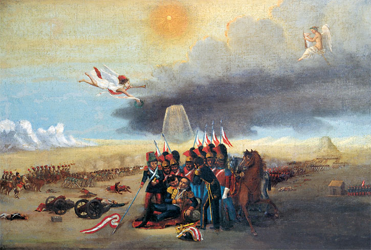
Ingavi is a province in the La Paz Department in Bolivia. This is where the Battle of Ingavi occurred on November 18, 1841 and where the World Heritage Site of Tiwanaku is situated. During the presidency of Eliodoro Villazón the province was founded on December 16, 1909 with Viacha as its capital. Geography Ingavi lies on the southern shore of Lake Titicaca. The Chilla-Kimsa Chata mountain range traverses the province. Some of the highest mountains of the province are listed below: Subdivision Ingavi Province is divided into seven municipalities which are partly further subdivided into cantons. Population The people are predominantly indigenous citizens of Aymara descent. Tourist attractions Some of the tourist attractions of the municipalities are: Touri ... [...More Info...] [...Related Items...] OR: [Wikipedia] [Google] [Baidu] |
Gateway Of The Sun
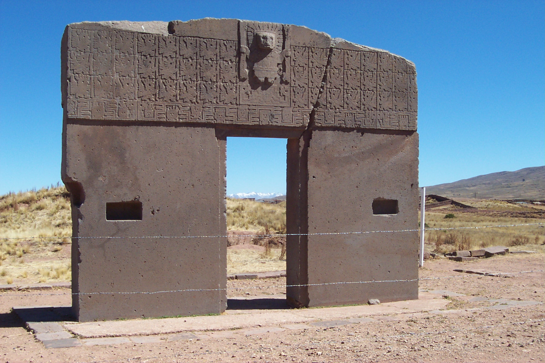
The Gate of the Sun, also known as the Gateway of the Sun, is a monolith carved in the form of an arch or gateway at the site of Tiahuanaco by the Tiwanaku culture, an Andean civilizations, Andean civilization of Bolivia that thrived around Lake Titicaca in the Andes of western South America around 500-950 CE. Tiwanaku is located near Lake Titicaca at about above sea level near La Paz, Bolivia. The Gate of the Sun is approximately tall and wide, and was carved from a single piece of stone. Its weight is estimated to be 10 tons. When rediscovered by European explorers in the mid-19th century, the megalith was lying horizontally and had a large crack through it. It presently stands in the location where it was found, although it is believed that this is not its original site, which remains uncertain. Some elements of Tiwanaku iconography spread throughout Peru and parts of Bolivia. Although there have been various modern interpretations of the mysterious inscriptions found on ... [...More Info...] [...Related Items...] OR: [Wikipedia] [Google] [Baidu] |
Apachita (Ingavi)
Apachita (Aymara for the place of transit of an important pass in the principal routes of the Andes; name for a stone cairn in the Andes, a little pile of rocks built along the trail in the high mountains, Hispanicized spelling ''Apacheta'') is a mountain in the Chilla-Kimsa Chata mountain range in the Andes of Bolivia. It lies in the La Paz Department, Ingavi Province, Jesús de Machaca Municipality Jesús de Machaca Municipality is the sixth municipal section of the Ingavi Province in the La Paz Department in Bolivia. It was created by Law No. 2351 on May 7, 2002, during the presidency of Jorge Quiroga Ramírez. Its seat is Jesús de M ..., north-east of Ch'ama ''(Chama)''. Apachita is situated south-west of the mountain Ch'utu Wankarani and north-east of the mountain Imill Wawani. References Mountains of La Paz Department (Bolivia) {{LaPazBO-geo-stub ... [...More Info...] [...Related Items...] OR: [Wikipedia] [Google] [Baidu] |
Jisk'a Sallalla
Jisk'a Sallalla (Aymara ''jisk'a'' little, ''sallalla'' a big heap of quinoa, ''Sallalla'' a mountain next to Jisk'a Sallalla, "little Sallalla", also spelled ''Jiskha Sallala'') is a mountain in the Chilla-Kimsa Chata mountain range in the Andes of Bolivia. It is situated in the La Paz Department, Ingavi Province, Jesús de Machaca Municipality Jesús de Machaca Municipality is the sixth municipal section of the Ingavi Province in the La Paz Department in Bolivia. It was created by Law No. 2351 on May 7, 2002, during the presidency of Jorge Quiroga Ramírez. Its seat is Jesús de M .... Jisk'a Sallalla lies south-west of the mountains Wisk'achani and Sallalla. (unnamed) References Mountains of La Paz Department (Bolivia) {{Bolivia-mountain-stub ... [...More Info...] [...Related Items...] OR: [Wikipedia] [Google] [Baidu] |
Jilarata (La Paz)
Jilarata is a mountain in the Chilla-Kimsa Chata mountain range in the Andes of Bolivia. It is located in the La Paz Department, Ingavi Province, Desaguadero Municipality. Jilarata lies south of Wiñaymarka Lake, the southern branch of Lake Titicaca, near Desaguadero and the Peru , image_flag = Flag of Peru.svg , image_coat = Escudo nacional del Perú.svg , other_symbol = Great Seal of the State , other_symbol_type = Seal (emblem), National seal , national_motto = "Fi ...vian border. Janq'u Jaqhi is northeast of it. References {{DEFAULTSORT:Jilarata (La Paz) Mountains of La Paz Department (Bolivia) ... [...More Info...] [...Related Items...] OR: [Wikipedia] [Google] [Baidu] |
Janq'u Jaqhi (Ingavi)
Janq'u Jaqhi (Aymara ''janq'u'' white, ''jaqhi'' precipice, cliff, "white cliff", also spelled ''Jankho Jakke'') is a mountain in the Chilla-Kimsa Chata mountain range in the Andes of Bolivia. It is situated in the La Paz Department, Ingavi Province, Desaguadero Municipality. Janq'u Jaqhi lies south of Wiñaymarka Lake, the southern branch of Lake Titicaca Lake Titicaca (; es, Lago Titicaca ; qu, Titiqaqa Qucha) is a large freshwater lake in the Andes mountains on the border of Bolivia and Peru. It is often called the highest navigable lake in the world. By volume of water and by surface area, i .... References Mountains of La Paz Department (Bolivia) {{LaPazBO-geo-stub ... [...More Info...] [...Related Items...] OR: [Wikipedia] [Google] [Baidu] |
Jani Lawani
Jani Lawani (Aymara) is a mountain in the Chilla-Kimsa Chata mountain range in the Andes of Bolivia. It is located in the La Paz Department, Ingavi Province, Jesús de Machaca Municipality, and in the Los Andes Province, Laja Municipality. Jani Lawani lies south of Wiñaymarka Lake, the southern branch of Lake Titicaca, northwest of Siqurini, Phujtir Pata Punta and Asir Kunka Asir Kunka or Asiru Kunka (Aymara ''asiru'' snake, ''kunka'' throat, "snake throat", also spelled ''Acerkunka'') is a mountain in the Chilla-Kimsa Chata mountain range in the Andes of Bolivia. It lies in the La Paz Department, at the border o .... References Mountains of La Paz Department (Bolivia) {{LaPazBO-geo-stub ... [...More Info...] [...Related Items...] OR: [Wikipedia] [Google] [Baidu] |
Jach'a Uma Chuwani
Jach'a Uma Chuwani (Aymara ''jach'a'' big, ''uma'' water, ''chuwa'' little bowl, ''-ni'' a suffix to indicate ownership, "the one with a big water bowl", also spelled ''Jacha Uma Chuani'') is a mountain in the Chilla-Kimsa Chata mountain range in the Andes of Bolivia. It is situated in the La Paz Department, Ingavi Province, at the border of the Guaqui Municipality and the Jesús de Machaca Municipality Jesús de Machaca Municipality is the sixth municipal section of the Ingavi Province in the La Paz Department in Bolivia. It was created by Law No. 2351 on May 7, 2002, during the presidency of Jorge Quiroga Ramírez. Its seat is Jesús de M .... (unnamed, south-east of the mountain Santa Rosa) References Mountains of La Paz Department (Bolivia) {{LaPazBO-geo-stub ... [...More Info...] [...Related Items...] OR: [Wikipedia] [Google] [Baidu] |
Imill Wawani
Imill Wawani (Aymara ''mimilla, imilla, mimilla wawa'' girl, ''ni'' a suffix to indicate ownership, "the one with a girl", Hispanicized spelling ''Imillhuahuani'') is a mountain in the Chilla-Kimsa Chata mountain range in the Andes of Bolivia. It is situated in the La Paz Department, Ingavi Province, Jesús de Machaca Municipality, north-east of Ch'ama ''(Chama)''. Imill Wawani lies south-west of the mountain Apachita and south-east of the mountain Jisk'a Sallalla Jisk'a Sallalla (Aymara ''jisk'a'' little, ''sallalla'' a big heap of quinoa, ''Sallalla'' a mountain next to Jisk'a Sallalla, "little Sallalla", also spelled ''Jiskha Sallala'') is a mountain in the Chilla-Kimsa Chata mountain range in the An .... (unnamed) References Mountains of La Paz Department (Bolivia) {{LaPazBO-geo-stub ... [...More Info...] [...Related Items...] OR: [Wikipedia] [Google] [Baidu] |
Ch'utu Wankarani
Ch'utu Wankarani (Aymara ''ch'utu'' peak of a mountain, top of the head, ''wankara'' a kind of drum, ''ni'' a suffix to indicate ownership, Hispanicized spelling ''Choto Huancarani'') is a mountain in the Chilla-Kimsa Chata mountain range in the Andes of Bolivia. It is located in the La Paz Department, Ingavi Province, Jesús de Machaca Municipality, northeast of Ch'ama ''(Chama)''. Ch'utu Wankarani lies northeast of Imill Wawani and Apachita and southeast of Jisk'a Sallalla Jisk'a Sallalla (Aymara ''jisk'a'' little, ''sallalla'' a big heap of quinoa, ''Sallalla'' a mountain next to Jisk'a Sallalla, "little Sallalla", also spelled ''Jiskha Sallala'') is a mountain in the Chilla-Kimsa Chata mountain range in the An ... and Wisk'achani. The Wila Jaqhi Jawira ("red rock river", also spelled ''Wila Jakke Jahuira, Wila Jaqi Jawira'') originates near Ch'utu Wankarani. It flows to the northeast. References Mountains of La Paz Department (Bolivia) {{LaPazBO-geo-stu ... [...More Info...] [...Related Items...] OR: [Wikipedia] [Google] [Baidu] |
Ch'alla Qullu (La Paz)
Ch'alla Qullu (Aymara ''ch'alla'' sand, ''qullu'' mountain, "sand mountain", also spelled ''Challa Kkollu'') is a mountain in the Chilla-Kimsa Chata mountain range in the Andes of Bolivia which reaches a height of about . It is located in the La Paz Department, Ingavi Province, Jesús de Machaca Municipality. Ch'alla Qullu lies northwest of Chhuxlla Willk'i Chhuxlla Willk'i (Aymara ''chhuxlla'' grass, weed, pasture or a kind of barley, ''willk'i'' gap, "pasture gap" or "barley gap", also spelled ''Chojlla Willkhi'') is a mountain in the Chilla-Kimsa Chata mountain range in the Andes of Bolivia. It .... The Ch'uñu Jawira (" ch'uñu river", ''Chuñu Jahuira'') originates near the mountain. It flows to the south as a right affluent of the Jach'a Jawira. (unnamed) References Mountains of La Paz Department (Bolivia) {{LaPazBO-geo-stub ... [...More Info...] [...Related Items...] OR: [Wikipedia] [Google] [Baidu] |
Chhuxlla Willk'i
Chhuxlla Willk'i (Aymara ''chhuxlla'' grass, weed, pasture or a kind of barley, ''willk'i'' gap, "pasture gap" or "barley gap", also spelled ''Chojlla Willkhi'') is a mountain in the Chilla-Kimsa Chata mountain range in the Andes of Bolivia. It lies in the La Paz Department, Ingavi Province, Jesús de Machaca Municipality Jesús de Machaca Municipality is the sixth municipal section of the Ingavi Province in the La Paz Department in Bolivia. It was created by Law No. 2351 on May 7, 2002, during the presidency of Jorge Quiroga Ramírez. Its seat is Jesús de M .... Chhuxlla Willk'i is situated south-east of the mountain named Qala Cruz ''(Khala Cruz)'' and Ch'alla Qullu ("sand mountain", ''Challa Kkollu''), and north-east of a mountain which is also called Qala Cruz. (unnamed) References Mountains of La Paz Department (Bolivia) {{LaPazBO-geo-stub ... [...More Info...] [...Related Items...] OR: [Wikipedia] [Google] [Baidu] |
Chuqi Q'awa (Chuñuni Jawira)
Chuqi Q'awa (Aymara ''chuqi'' gold, ''q'awa'' little river, ditch, crevice, fissure, gap in the earth, "gold brook" or "gold ravine", Hispanicized spelling ''Choque Khaua'') is a mountain in the Chilla-Kimsa Chata mountain range in the Andes of Bolivia. It lies in the La Paz Department, Ingavi Province, in the north of the Jesús de Machaca Municipality, near the border with the Tiwanaku Municipality Tiwanaku Municipality is the third municipal section of the Ingavi Province in the La Paz Department, Bolivia. Its seat is the village of Tiwanaku located near the UNESCO World Heritage Site Tiwanaku. Cantons The municipality is divided int .... Chuqi Q'awa is situated south of the river Chuñuni Jawira ''(Chununi Jahuira)''. Chuqi Q'awa is also the name of the river which originates south of the mountain. Its waters flows to Jach'a Jawira in the south. (unnamed) References Mountains of La Paz Department (Bolivia) {{LaPazBO-geo-stub ... [...More Info...] [...Related Items...] OR: [Wikipedia] [Google] [Baidu] |

