|
Indigenous Peoples In Bolivia
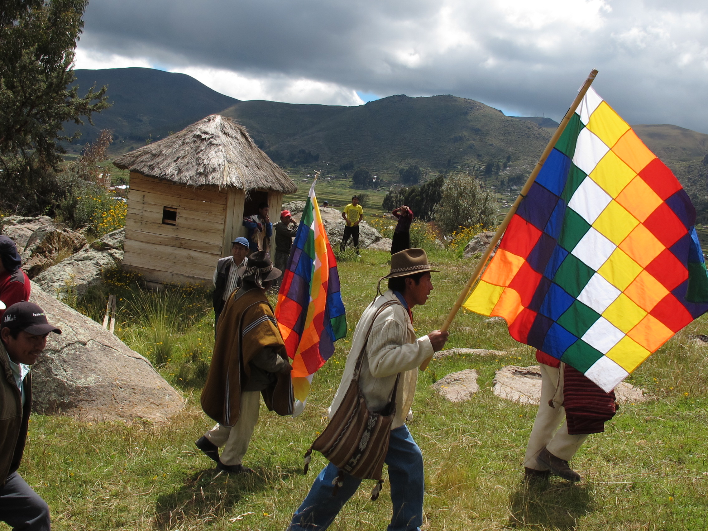
Indigenous peoples in Bolivia, or Native Bolivians, are Bolivian people who are of indigenous ancestry. They constitute anywhere from 40 to 70% of Bolivia's population of 11,306,341, depending on different estimates, and belong to 36 recognized ethnic groups. Aymara and Quechua are the largest groups."Indigenous peoples in Bolivia." ''International Work Group for Indigenous Affairs.'' Retrieved 2 Dec 2013. The geography of Bolivia includes the , the , and the |
Aymara Ceremony Copacabana 1
Aymara may refer to: Languages and people * Aymaran languages, the second most widespread Andean language ** Aymara language, the main language within that family ** Central Aymara, the other surviving branch of the Aymara(n) family, which today includes only the endangered Jaqaru/Kawki language * Aymara people, the native ethnic group identified with the speakers of Altiplano Aymara Culture * '' Corazón Aymara'' (English: ''Aymara Heart''), 1925 Bolivian silent feature film directed by Pedro Sambarino * Grupo Aymara, Bolivian folk troupe of traditional music of pre-Hispanic and contemporary music of the Andes * Socialist Aymara Group (Spanish: ''Grupo Aymara Socialista''), left-wing indigenous political group in Bolivia Places * Aymaraes Province, the largest of seven provinces of the Apurímac Region in Peru * Aymara Lupaca Reserved Zone, a protected area in southeastern Peru Nature * '' Aymaramyia'', genus of crane bird found in Peru * '' Aymaratherium'', genus of extin ... [...More Info...] [...Related Items...] OR: [Wikipedia] [Google] [Baidu] |
Bolivian People
Bolivians ( es, Bolivianos) are people identified with the country of Bolivia. This connection may be residential, legal, historical or cultural. For most Bolivians, several (or all) of these connections exist and are collectively the source of their being Bolivian. Bolivia is, as its neighboring countries, a multiethnic and multilingual society, home to people of various ethnic, religious, and national origins, with the majority of the population made up of indigenous and Old World immigrants and their descendants. As a result, Bolivians do not equate their nationality with ethnicity, but with citizenship and allegiance to Bolivia. Aside from the indigenous populations, Bolivians trace their ancestry to the Old World, primarily Europe and Africa, ever since the Spanish conquest of South America and founding of first Spanish settlements in the Viceroyalty of the Río de la Plata. Modern Bolivian population, estimated at 11 million is formally broken down into Amerindians ... [...More Info...] [...Related Items...] OR: [Wikipedia] [Google] [Baidu] |
Yuki-Ichilo River Native Community Lands
The Yuki–Indigenous Council of the Ichilo River Native Community Lands ( es, Tierra Comunitaria de Origen Yuqui-Consejo Indígena Río Ichilo, abbreviated ''TCO Yuqui-CIRI''), originally the Yuki Indigenous Territory, is a collectively-owned indigenous territory in the province of Carrasco, Cochabamba, Bolivia, registered as a Native Community Land and titled by the National Agrarian Reform Institute in April 1997.INRA Title RTIT00-000006. Residents of the territory belong to the Yuki, Yuracaré, Trinitario, and Movima peoples. The titled territory consists of 115,924.9 hectares and had a population of 778 as of 2010. There are six indigenous communities located within the territory: Bia Recuaté (Yuki), Tres Islas, Puerto Las Flores, Tres Bocas (Yuracare), Capernaum (Movima), and Santa Isabel (Trinitario).INRA Title RTIT00-000006. See also * Indigenous peoples in Bolivia Indigenous peoples in Bolivia, or Native Bolivians, are Bolivian people who are of indigenous anc ... [...More Info...] [...Related Items...] OR: [Wikipedia] [Google] [Baidu] |
Pilón Lajas Biosphere Reserve And Communal Lands
Pilón Lajas Biosphere Reserve and Communal Lands (''Reserva de Biosfera y Tierra Comunitaria de Origen Pilón Lajas'') is a protected area in Bolivia located in the departments of La Paz La Paz (), officially known as Nuestra Señora de La Paz (Spanish pronunciation: ), is the seat of government of the Plurinational State of Bolivia. With an estimated 816,044 residents as of 2020, La Paz is the third-most populous city in Bol ... ( Sud Yungas, Larecaja and Franz Tamayo Province, Franz Tamayo provinces) and Beni Department, Beni (José Ballivián Province), in their northern and western parts, respectively, about 350 km northeast of La Paz and 50 km west of San Borja, Bolivia, San Borja. It lies largely within the Bolivian Yungas ecoregion. The main river that flows in the Pilon Lajas area is the Quiquibey River. As of 2004, the indigenous population of Pilón Lajas was 1,394, distributed across 25 communities. Predominantly these residents are members of the Moset ... [...More Info...] [...Related Items...] OR: [Wikipedia] [Google] [Baidu] |
Isiboro Sécure National Park And Indigenous Territory
Isiboro Sécure National Park and Indigenous Territory (''Territorio Indígena y Parque Nacional Isiboro Secure,'' TIPNIS) is a protected area and Native Community Land in Bolivia situated between the north of the Cochabamba Department and the south of the Beni Department ( Chapare, Moxos, and Marbán provinces). It protects part of the Bolivian Yungas ecoregion. The indigenous people living within the park belong to the Tsimané, Yuracaré, and Mojeño-Trinitario peoples. The southern portion of the park has been colonized by agricultural settlers, primarily coca farmers, since the 1970s. The Bolivian government estimates that 10% of the park has been deforested by their presence. Establishment The park was made into a National Park by Supreme Decree 7401 on November 22, 1965 and recognized as an indigenous territory (formally as Native Community Land) through Supreme Decree 22610 on September 24, 1990, following pressure by local native peoples and the March for Territ ... [...More Info...] [...Related Items...] OR: [Wikipedia] [Google] [Baidu] |
Kaa-Iya Del Gran Chaco National Park And Integrated Management Natural Area
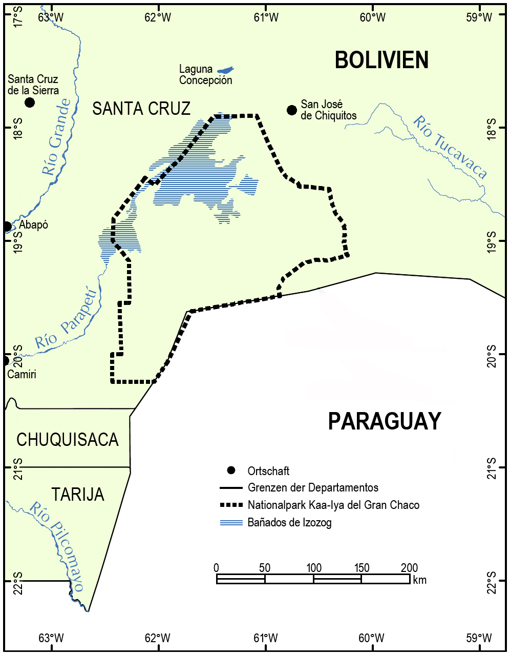
Kaa-Iya del Gran Chaco National Park and Integrated Management Natural Area (''Parque Nacional y Area Natural de Manejo Integrado Kaa-Iya del Gran Chaco)'' is the biggest national park in Bolivia and one of the largest in South America. It is a protected area in the region of the Gran Chaco and has a larger surface area than Belgium. It is situated in the south of Santa Cruz Department on the border with Paraguay in the Cordillera Province ( Charagua Municipality) and Chiquitos Province ( Pailón and San José de Chiquitos municipalities). Etymology Kaa-Iya is a term from Guarani mythology which means "mountain owners", or a place where riches are found, in the sense of abundance of natural resources and the relationship between man and nature. Geography *Area: 3,441,115 hectares (34,411.15 km2) *Altitude: between 100 and 839 meters above sea level. *Rainfall: 1,400 to 400 mm annually. *Hydrology: The principal river is the Parapetí, among many others. *C ... [...More Info...] [...Related Items...] OR: [Wikipedia] [Google] [Baidu] |
Hectare
The hectare (; SI symbol: ha) is a non-SI metric unit of area equal to a square with 100- metre sides (1 hm2), or 10,000 m2, and is primarily used in the measurement of land. There are 100 hectares in one square kilometre. An acre is about and one hectare contains about . In 1795, when the metric system was introduced, the ''are'' was defined as 100 square metres, or one square decametre, and the hectare ("hecto-" + "are") was thus 100 ''ares'' or km2 (10,000 square metres). When the metric system was further rationalised in 1960, resulting in the International System of Units (), the ''are'' was not included as a recognised unit. The hectare, however, remains as a non-SI unit accepted for use with the SI and whose use is "expected to continue indefinitely". Though the dekare/decare daa (1,000 m2) and are (100 m2) are not officially "accepted for use", they are still used in some contexts. Description The hectare (), although not a unit of SI, ... [...More Info...] [...Related Items...] OR: [Wikipedia] [Google] [Baidu] |
Native Community Lands
Native Community Lands ( es, Tierra Comunitaria de Origen, acronym: TCO; also translated as Communal Lands of Origin), according to Bolivian law, are territories held by indigenous people through collective title. The creation of these territories has been a major goal of Bolivian indigenous movements and a political initiative pursued by both neoliberal and indigenous-identified national governments. TCOs are being included under the Indigenous Originary Campesino Autonomy regime. , 60 TCOs had been proposed in the lowlands, of which 12 had completed titling, and 143 had been proposed in the highlands, of which 72 had final titles. More than 16.8 million hectares have been incorporated within Native Community Lands , more than 15% of Bolivia's land area. Titling of indigenous territories was propelled by the March for Territory and Dignity in July and August 1990, organized by the Confederation of Indigenous Peoples of the Bolivian East The Confederation of Indigenous Peoples of Bo ... [...More Info...] [...Related Items...] OR: [Wikipedia] [Google] [Baidu] |
Pueblos Originarios De Bolivia
The Puebloans or Pueblo peoples, are Native Americans in the Southwestern United States who share common agricultural, material, and religious practices. Currently 100 pueblos are actively inhabited, among which Taos, San Ildefonso, Acoma, Zuni, and Hopi are the best-known. Pueblo people speak languages from four different language families, and each Pueblo is further divided culturally by kinship systems and agricultural practices, although all cultivate varieties of maize. Pueblo peoples have lived in the American Southwest for millennia and descend from Ancestral Pueblo peoples. The term ''Anasazi'' is sometimes used to refer to ancestral Pueblo people but it is now largely minimized. ''Anasazi'' is a Navajo word that means ''Ancient Ones'' or ''Ancient Enemy'', hence Pueblo peoples' rejection of it (see exonym). ''Pueblo'' is a Spanish term for "village." When Spaniards entered the area, beginning in the 16th-century with the founding of Nuevo México, they came acros ... [...More Info...] [...Related Items...] OR: [Wikipedia] [Google] [Baidu] |
Mestizo
(; ; fem. ) is a term used for racial classification to refer to a person of mixed European and Indigenous American ancestry. In certain regions such as Latin America, it may also refer to people who are culturally European even though their ancestors are not. The term was used as an ethnic/racial category for mixed-race that evolved during the Spanish Empire. Although, broadly speaking, means someone of mixed European/Indigenous heritage, the term did not have a fixed meaning in the colonial period. It was a formal label for individuals in official documents, such as censuses, parish registers, Inquisition trials, and others. Priests and royal officials might have classified persons as mestizos, but individuals also used the term in self-identification. The noun , derived from the adjective , is a term for racial mixing that did not come into usage until the twentieth century; it was not a colonial-era term.Rappaport, Joanne. ''The Disappearing Mestizo'', p. 247. In the ... [...More Info...] [...Related Items...] OR: [Wikipedia] [Google] [Baidu] |
Amazon Rainforest
The Amazon rainforest, Amazon jungle or ; es, Selva amazónica, , or usually ; french: Forêt amazonienne; nl, Amazoneregenwoud. In English, the names are sometimes capitalized further, as Amazon Rainforest, Amazon Forest, or Amazon Jungle. or Amazonia is a moist broadleaf tropical rainforest in the Amazon biome that covers most of the Amazon basin of South America. This basin encompasses , of which are covered by the rainforest. This region includes territory belonging to nine nations and 3,344 formally acknowledged indigenous territories. The majority of the forest is contained within Brazil, with 60% of the rainforest, followed by Peru with 13%, Colombia with 10%, and with minor amounts in Bolivia, Ecuador, French Guiana, Guyana, Suriname, and Venezuela. Four nations have " Amazonas" as the name of one of their first-level administrative regions, and France uses the name " Guiana Amazonian Park" for its rainforest protected area. The Amazon represents over half of ... [...More Info...] [...Related Items...] OR: [Wikipedia] [Google] [Baidu] |


